GG 1113: Survey of Earth Sciences I: Physical Geology - Southeast ...
GG 1113: Survey of Earth Sciences I: Physical Geology - Southeast ...
GG 1113: Survey of Earth Sciences I: Physical Geology - Southeast ...

Create successful ePaper yourself
Turn your PDF publications into a flip-book with our unique Google optimized e-Paper software.
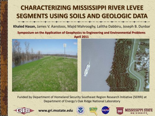
CHARACTERIZING MISSISSIPPI RIVER LEVEE<br />
SEGMENTS USING SOILS AND GEOLOGIC DATA<br />
Khaled Hasan, James V. Aanstoos, Majid Mahrooghy, Lalitha Dabbiru, Joseph B. Dunbar<br />
Symposium on the Application <strong>of</strong> Geophysics to Engineering and Environmental Problems<br />
April 2011<br />
Funded by Department <strong>of</strong> Homeland Security <strong>Southeast</strong> Region Research Initiative (SERRI) at<br />
Department <strong>of</strong> Energy's Oak Ridge National Laboratory<br />
www.gri.msstate.edu
Project Purpose: Develop new methods and s<strong>of</strong>tware for<br />
improving knowledge <strong>of</strong> the condition <strong>of</strong> levees, giving levee<br />
managers new tools to prioritize their efforts.<br />
www.gri.msstate.edu
Objectives<br />
Develop new methods <strong>of</strong> using remotely sensed<br />
data; primarily SAR, to support an efficient and costeffective<br />
levee condition assessment and screening<br />
procedures.<br />
Deliver s<strong>of</strong>tware supporting these techniques with<br />
robust levee segmentation and classification<br />
algorithms for performing rapid assessment <strong>of</strong> levee<br />
condition.<br />
Disseminate this technology to key stakeholders,<br />
involving them in the testing and evaluation.<br />
www.gri.msstate.edu
How Levee Fails?<br />
Dunbar 2010<br />
www.gri.msstate.edu
Characteristics <strong>of</strong> the Slough Slides;<br />
Occurs in the Riverside <strong>of</strong> the Levee<br />
www.gri.msstate.edu
Characteristics <strong>of</strong> the Sand Boils;<br />
Occurs in the Landside <strong>of</strong> the Levee<br />
www.gri.msstate.edu
Where Levee fails?<br />
Unfavorable parameters:<br />
Soils – expansive, cohesion, varying permeability<br />
Sediments – influences soil characteristics<br />
Hydrology – flooding, seepage/piping<br />
Climate – alternating wet and dry seasons<br />
Geomorphology – erosion, proximity to water<br />
www.gri.msstate.edu
Tools to identify Weak Zones<br />
SAR Remote Sensing<br />
Airborne UAVSAR L band<br />
Satellite based TerraSAR-X<br />
Field data to support RS<br />
USACE and Mississippi Levee Board<br />
Collected by field teams<br />
Unfavorable parameters data<br />
Collected from responsible agencies<br />
www.gri.msstate.edu
Status <strong>of</strong> SAR Data<br />
UAVSAR data<br />
2 sets acquired (June 2009 and January 2010)<br />
2 more to be acquired (May and June 2011)<br />
TerraSAR-X data<br />
4 sets acquired in 2010 (August – September)<br />
4 sets acquired in 2011 (February – April)<br />
11 sets to be acquired in 2011 (April – July)<br />
www.gri.msstate.edu
www.gri.msstate.edu
Status <strong>of</strong> SAR processing<br />
Ongoing with promising outputs<br />
Entropy, Anisotropy, H-α Classification<br />
Artificial Neural Network<br />
Textural Classification<br />
Multi-temporal vegetation classification<br />
Soil moisture mapping<br />
Interferometry to detect surface movement<br />
Ideas to come….<br />
www.gri.msstate.edu
The Wishart classification results detected some slough slides<br />
(in Orange) in June 2009 image but by January 2010 they were<br />
repaired and no longer detected by the classifier<br />
June 2009 UAVSAR<br />
January 2010 UAVSAR<br />
www.gri.msstate.edu
Clustering Along Levee Using UAVSAR HH, VV, HV<br />
backscattering with wavelet and texture features<br />
Slides<br />
www.gri.msstate.edu
GIS Analysis <strong>of</strong> unfavorable parameters<br />
to identify/narrow vulnerable zones<br />
Soils: Sand (Riverside) meets Clay<br />
(Landside) at the levee – from NRCS/STI<br />
River Channels and/or large lakes at close<br />
proximity to the levee – from Images<br />
Erosion zones at close proximity to the<br />
levee – from images<br />
Slide events – data from Levee Board<br />
www.gri.msstate.edu
Soil Data and Soil Data Viewer s<strong>of</strong>tware from NRCS, USDA<br />
Soil Data Buffered along Levee<br />
County Boundaries<br />
UAVSAR Image Extent<br />
www.gri.msstate.edu
26 slide events reported by levee board in 2010<br />
18 within 65% Sand (RS)<br />
and 65% Clay (LS) zones<br />
13 within 85% Sand (RS)<br />
and 65% Clay (LS) zones but<br />
Misses the central part<br />
www.gri.msstate.edu
<strong>Geology</strong> map need more details to be useful in zoning<br />
www.gri.msstate.edu
Buffering River, Waterbody & Erosion zones to calculate proximity to Slides<br />
www.gri.msstate.edu
Uniting them all!<br />
If <strong>Geology</strong> factor is not considered, only 3 events<br />
does not have any <strong>of</strong> these unfavorable parameters<br />
www.gri.msstate.edu
Relationship between Slides and Unfavorable Parameters<br />
Slides are closer to: Lakes in the south, River in the north<br />
www.gri.msstate.edu
High Vulnerability 65%, 23 slides<br />
Mod Vulnerability 65%, 18 slides<br />
(slightly less area than sand vs. clay 65%)<br />
www.gri.msstate.edu
High Vulnerability 65%, 23 slides<br />
High Vulnerability 65%, 22 slides,<br />
AND option discarded; shows 11 events<br />
Significant reduction<br />
in vulnerable section<br />
www.gri.msstate.edu
Mod Vulnerability 85% Clay 65, 17slides<br />
Mod Vulnerability 65%, 18 slides<br />
Significant reduction<br />
in vulnerable section<br />
www.gri.msstate.edu
This will help in identifying<br />
zones with greater potential<br />
<strong>of</strong> vulnerability based on<br />
the natural parameters and<br />
will support the SAR study<br />
in narrowing down target<br />
areas on the Levee<br />
Best Option with High Vulnerability<br />
65%, 22 slides,<br />
Best Option with Moderate Vulnerability<br />
65%, 18 slides<br />
www.gri.msstate.edu
www.gri.msstate.edu<br />
Questions?