
You also want an ePaper? Increase the reach of your titles
YUMPU automatically turns print PDFs into web optimized ePapers that Google loves.
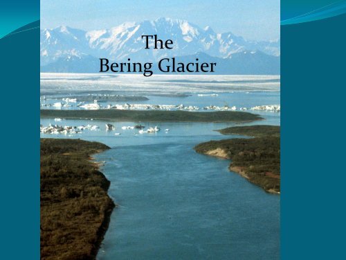
<strong>The</strong><br />
<strong>Bering</strong> <strong>Glacier</strong>
<strong>The</strong> coast of Alaska and the region around <strong>Bering</strong> <strong>Glacier</strong> has a long<br />
History of human occupation and subsistence use.
Vitus <strong>Bering</strong><br />
Born: 1681<br />
Denmark<br />
First Voyage 1725<br />
Discovered the southern<br />
Coast of Alaska and<br />
Aleutian Islands in 1741<br />
Died: December 19, 1741<br />
on <strong>Bering</strong> Island
•Don Miller of USGS investigated the <strong>Bering</strong> <strong>Glacier</strong> Region and mapped the<br />
geology of the area in the 1940s<br />
•Austin Post began a multi-year systematic study between 1960-1963
•Between 1980 and 2002 the USGS conducted annual research at the glacier.<br />
•After the 1995 surge the BLM took an active role developing multidisciplinary<br />
research and operated the local camp from FY 2000 to the present.
•<strong>Bering</strong> <strong>Glacier</strong> is located south of Alaska's Wrangell-St. Elias National Park<br />
about 10 km from the Gulf of Alaska, combined with the Bagley Ice Field.<br />
•<strong>The</strong> BLM lands comprise approximately 827 thousand acres below the<br />
glacier and a portion of the forelands.
•<strong>Bering</strong> <strong>Glacier</strong> is 7% of Glacial Area of Alaska and may<br />
contain 15-20% of Alaska’s total <strong>Glacier</strong> Ice.
•Largest and Longest <strong>Glacier</strong> in Continental North America area of 5,000 sq km<br />
and 190 km in length.<br />
•<strong>The</strong> glacier exhibits surge events and has surged at least six times in the past 150<br />
years.
•<strong>Bering</strong> <strong>Glacier</strong> is the Largest Surging <strong>Glacier</strong> in North America<br />
and surges on a cycle of every 20-25 years.<br />
•<strong>The</strong> last surge took place in 1994/1995 and moved forward at a<br />
rate of 300 feet/day.<br />
•Because of the surging/retreat cycle of the glacier it is one of the<br />
most dynamic places on earth.<br />
Out burst movie….
•Recent examination of the glacier shows signs of a surge in 2011
QQQQ
<strong>The</strong> <strong>Glacier</strong> has retreated<br />
approximately .6 miles<br />
per year since the retreat<br />
of 1995.
•<strong>The</strong> glacier annually releases approximately 30 cubic kilometers of water<br />
into the gulf of Alaska, twice the amount of water in the entire Colorado<br />
River.
•Because of the sheer size of the glacier and its dynamic nature<br />
provides opportunities for research rarely found anywhere else on the<br />
planet.
<strong>Bering</strong> <strong>Glacier</strong> Research Camp
John Payne, BLM/NSSI<br />
Project Manager
Scott Guyer BLM<br />
Camp Manager<br />
Logistics<br />
Cook
Bob Shuchman and Liza Jenkins MTRI<br />
remote sensing<br />
ablation<br />
water quality
Chris Noyles BLM<br />
Nathan Rathbun<br />
& Jack Frost, BLM
High School Student Program
UAA Geology Team
Anne Pasch,<br />
UAA Paleontology<br />
Jennifer Burns, UAA<br />
Marine mammals
Danielle Dickson, UAA Seal Biologist
Southern University and MTRI
Heidi Weigner, UAA Fisheries
Southern University
Kris Crossin UAA
Michigan Tech Research Institute and Southern University
Danielle Allen, BLM Public Affairs<br />
and Rachel Wolf Radio Tech
BLM Resource Advisory Council Tour 2005
Jay Fleshier University<br />
of New York and Earth<br />
Watch
Ian Shennan University of Durham, UK
Marilyn Barker UAA and<br />
Alan Batten UAF Botany Team
<strong>Glacier</strong> Ablation Measurements
Steam drill used to place<br />
ablation equipment.
MTRI/BLM developed<br />
GASS (glacier ablation<br />
sensing system)<br />
Ablation<br />
GPS<br />
Temperature<br />
Wind speed<br />
Humidity<br />
Barometric pressure<br />
Light intensity
Recalibration of GASS through out the summer
Down loading ablation data
“I am going to need a<br />
longer cord for this one!”
Should have been here<br />
two weeks ago!
Melt rate as a function of Altitude
Observations:<br />
• At elevations
Observations continued:<br />
• Discharge form Vitus lake strongly influences the entire<br />
coastal marine ecosystem.<br />
• Changes in discharge rates due to climate change could<br />
alter the rich and diverse marine habitat important to<br />
salmon and marine mammals.
A few days later<br />
Thinning leads to<br />
catastrophic failure of<br />
the terminus
What governs the exchange of water between Vitus Lake and GOA?
Steady state level of Vitus Lake<br />
Oscillating lake level<br />
Evaluate the friction<br />
coefficient “K” using our<br />
measurements of:<br />
Flow in Seal River, ADCP ( *), match<br />
measured with model<br />
Lake levels (Red line), match<br />
attenuation and phase shift<br />
Bathymetry of Vitus Lake<br />
Forced with the tides in the Gulf of<br />
Alaska<br />
It is hard for the tides to get salt<br />
water up the river into Vitus Lake
QUESTIONS?