Carlyle Lake Final Plan.pdf - Fayette County Soil & Water ...
Carlyle Lake Final Plan.pdf - Fayette County Soil & Water ...
Carlyle Lake Final Plan.pdf - Fayette County Soil & Water ...

Create successful ePaper yourself
Turn your PDF publications into a flip-book with our unique Google optimized e-Paper software.
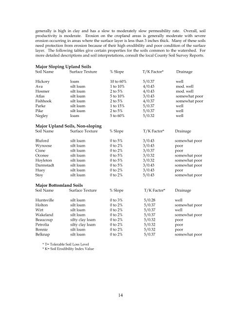
generally is high in clay and has a slow to moderately slow permeability rate. Overall, soil<br />
productivity is moderate. Erosion on the cropland areas is generally moderate with severe<br />
erosion occurring in areas where the surface layer is less than 3 inches thick. Many of these soils<br />
need protection from erosion because of their high erodibility and poor condition of the surface<br />
layer. The following tables give certain properties for the soils common to the watershed. For<br />
more detailed descriptions and soil interpretations, consult the local <strong>County</strong> <strong>Soil</strong> Survey Reports.<br />
Major Sloping Upland <strong>Soil</strong>s<br />
<strong>Soil</strong> Name Surface Texture % Slope T/K Factor* Drainage<br />
Hickory loam 10 to 60% 5/0.37 well<br />
Ava silt loam 1 to 10% 4/0.43 mod. well<br />
Hosmer silt loam 2 to 5% 4/0.43 mod. well<br />
Atlas silt loam 5 to 10% 3/0.43 somewhat poor<br />
Fishhook silt loam 2 to 5% 4/0.37 somewhat poor<br />
Parke silt loam 1 to 15% 5/0.37 well<br />
Pike silt loam 2 to 5% 5/0.37 well<br />
Negley loam 5 to 60% 5/0.32 well<br />
Major Upland <strong>Soil</strong>s, Non-sloping<br />
<strong>Soil</strong> Name Surface Texture % Slope T/K Factor* Drainage<br />
Bluford silt loam 0 to 5% 3/0.43 somewhat poor<br />
Wynoose silt loam 0 to 2% 3/0.43 poor<br />
Cisne silt loam 0 to 2% 3/0.37 poor<br />
Oconee silt loam 0 to 5% 3/0.32 somewhat poor<br />
Hoyleton silt loam 0 to 5% 3/0.32 somewhat poor<br />
Darmstadt silt loam 0 to 5% 3/0.43 somewhat poor<br />
Huey silt loam 0 to 2% 3/0.43 poor<br />
Stoy silt loam 0 to 2% 5/0.43 somewhat poor<br />
Major Bottomland <strong>Soil</strong>s<br />
<strong>Soil</strong> Name Surface Texture % Slope T/K Factor* Drainage<br />
Huntsville silt loam 0 to 3% 5/0.28 well<br />
Holton silt loam 0 to 2% 5/0.37 somewhat poor<br />
Wirt silt loam 0 to 2% 5/0.37 well<br />
Wakeland silt loam 0 to 2% 5/0.37 somewhat poor<br />
Beaucoup silty clay loam 0 to 2% 5/0.32 poor<br />
Petrolia silty clay loam 0 to 2% 5/0.32 poor<br />
Bonnie silt loam 0 to 2% 5/0.32 poor<br />
Belknap silt loam 0 to 2% 5/0.37 somewhat poor<br />
* T= Tolerable <strong>Soil</strong> Loss Level<br />
* K= <strong>Soil</strong> Erodibility Index Value<br />
14