March - The Alberta Land Surveyors
March - The Alberta Land Surveyors
March - The Alberta Land Surveyors

Create successful ePaper yourself
Turn your PDF publications into a flip-book with our unique Google optimized e-Paper software.
news<br />
ALSMARCH 2008 VOL. 37-1<br />
ISSN<br />
0703-4228<br />
PRODUCED QUARTERLY FOR CIRCULATION TO THE MEMBERS OF THE ALBERTA LAND SURVEYORS' ASSOCIATION
www.spatialtechnologies.ca<br />
Calgary:<br />
P: 403.252.0070<br />
F: 403.259.3992<br />
TF: 1.877.252.0070<br />
Edmonton:<br />
P: 780.486.2111<br />
F: 780.486.2155<br />
TF: 1.877.990.7788<br />
On the right track...<br />
GPS AT ITS BEST ScoutPak’s sleek design<br />
holds a powerful GPS engine, one meant<br />
for tracking in dense canopy and into<br />
the forest’s deepest areas.<br />
ScoutPak is the best GPS solution on the market when comparing<br />
signal tracking under canopy and position accuracy.<br />
Optimal EZSurv,from OnPOZ Precision Positioning.<br />
Automatically post-process GPS data at the touch of a key.<br />
All you need is your GPS field data files and an Internet connection.<br />
EZSurvautomatically performs all processing tasks required to<br />
deliver the best results from your field data.
www.spatialtechnologies.ca<br />
Calgary:<br />
P: 403.252.0070<br />
F: 403.259.3992<br />
TF: 1.877.252.0070<br />
Edmonton:<br />
P: 780.486.2111<br />
F: 780.486.2155<br />
TF: 1.877.990.7788<br />
Tracking you down!<br />
INTRODUCING<br />
Lease Tracker, a Navigation<br />
Tool that can be used to locate<br />
any oil and gas location in<br />
Western Canada.<br />
This device can be used by surveyors, seismic crews, drilling<br />
companies, farmers and any other industry that uses the <strong>Alberta</strong><br />
Township reference system. You simply type in a LSD location<br />
(Example:16-21-056-25W4) and your GPS will provide you with<br />
turn-by-turn voice guided directions to the exact location.<br />
This is a revolutionary technology that will help cut down on lost time,<br />
gasoline consumption and improve driver safety. With this software there<br />
is no more getting lost on back roads or trying to figure out where you<br />
are based on a paper map. This software is easy to use and the data is<br />
updated regularly. <strong>The</strong> Lease Tracker can be used in British<br />
Columbia, <strong>Alberta</strong>, Saskatchewan and Manitoba.<br />
Also check out Property Tracker for voice-guided directions to<br />
any quarter section in <strong>Alberta</strong>.
Thank you to our customers, staff and<br />
partners for helping us re-qualify as one<br />
of Canada’s 50 Best Managed Companies.<br />
11025-184 Street, Edmonton West<br />
780•483•9559<br />
9503-34 Avenue, Edmonton South<br />
780•439•9559<br />
Toll Free 1•800•936•9353<br />
Edmonton • Leduc/Edm Int Airport • Fort Saskatchewan • Calgary • Fort McMurray • Saskatoon<br />
Vancouver • Fort St. John • Iqaluit • Albuquerque
Monitor structural movement in any kind of city.<br />
Well, almost any kind.<br />
Introducing our most powerful surveying<br />
and monitoring system yet. <strong>The</strong> Trimble ® S8 <br />
Total Station. A top-of-the-line performer, it<br />
offers the ultimate in flexibility and surveying<br />
precision. <strong>The</strong> Trimble S8 also packs a punch<br />
with structural monitoring capabilities ideal<br />
for handling a wide range of applications,<br />
from tunneling to transportation, with<br />
unsurpassed ease and accuracy.<br />
Featuring innovative new FineLock <br />
technology, the Trimble S8 can detect any<br />
structural movement—crucial, when working<br />
in high-consequence situations. Add to this,<br />
state-of-the-art software for lightning fast<br />
data analysis, and you have a total package<br />
certain to expand your options and your<br />
business, instantly.<br />
Learn more about the all-powerful<br />
Trimble S8 for yourself.<br />
Visit www.trimble.com/S8<br />
TRIMBLE NAVIGATION LTD.<br />
Tel: 1.800.563.7184 Fax: 1.416.252.8635 Email; info_trimble_canada@trimble.com<br />
© 2007, Trimble Navigation Limited. All rights reserved. Trimble and the Globe & Triangle logo are trademarks of Trimble Navigation Limited,<br />
registered in the United States and in other countries. S8 and FineLock are trademarks of Trimble Navigation Limited. SUR-160<br />
Architectural model courtesy of Archetype 3D and Riverfront Park.
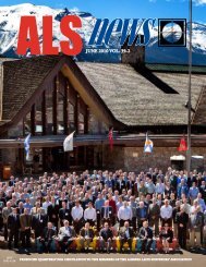
news<br />
ALS<strong>March</strong> 2008 Vol. 37-1<br />
contents<br />
23 28<br />
38<br />
features<br />
21 Multimedia Data as Boundary Determination Evidence in <strong>Alberta</strong> by Dr. Michael Barry<br />
23 Relating GPS Boundaries to Ground Distances and Bearings by Dr. Rob Radovanovic, ALS<br />
28 Keeper of Lost Records by Andreas N. Corsos<br />
38 <strong>Land</strong> Survey System Featured at the History Centre by Gordon E. Olsson, ALS<br />
44 Self-Regulating Professions - Balancing Competition and Regulation<br />
by the Competition Bureau of Canada<br />
regulars<br />
5 President’s Message<br />
7 Councillors Forum<br />
9 Editor’s Notes<br />
11 Letters<br />
13 Association Notes<br />
19 Nominations for Council<br />
25 Book Review<br />
35 Professional Development<br />
37 Public Relations<br />
39 Safety Sense<br />
41 Discipline<br />
43 <strong>Alberta</strong> Sustainable<br />
Resource Development<br />
47 Education<br />
49 Legal Notes<br />
51 ASSMT Notes<br />
52 History<br />
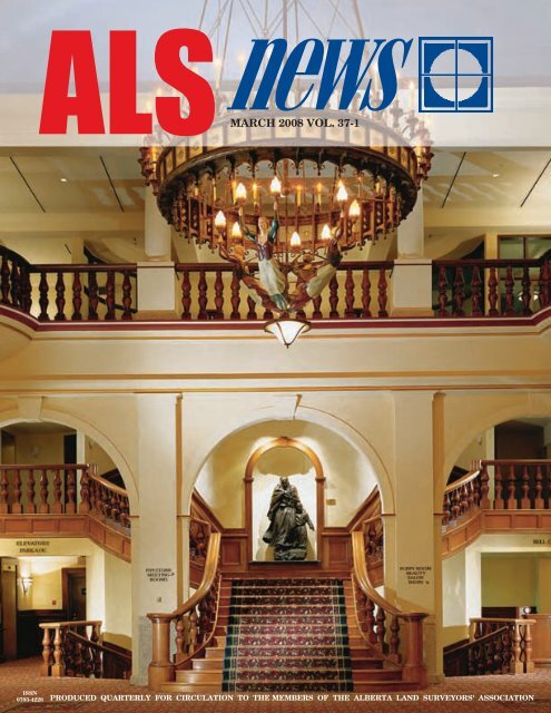
Cover photo is of the main lobby at the Fairmont Chateau Lake<br />
Louise courtesy of Fairmont Hotels and Resorts.<br />
President<br />
Past President<br />
Vice President<br />
Secretary Treasurer and Registrar<br />
Executive Director<br />
Acting Director of Practice Review<br />
Councillors<br />
Public Members<br />
R.M. (Bob) Wallace<br />
D.H. (Dirk) VandenBrink<br />
R.O. (Ron) Hall<br />
D.R. (Dave) McWilliam<br />
B.E. (Brian) Munday<br />
D.R. (Don) George<br />
B.A. (Bruce) Beairsto<br />
B.W. (Bruce) Gudim<br />
T.J. (Tim) Harding<br />
T.W. (Terry) Hudema<br />
R. (Rob) Radovanovic<br />
B.D. (Brian) Ross,<br />
D.R. (Russell) Barnes (Council)<br />
R. (Rudy) Palovcik (Practice Review Board)<br />
Editor Brian E. Munday (munday@alsa.ab.ca)<br />
Advertising and Production Sharon D. Armstrong (armstrong@alsa.ab.ca)<br />
Deadline dates for submission of articles to ensure printing are as follows: February 15th, June 1st,<br />
September 1st, and November 15th. Advertising deadline dates are as follows: February 1st, May<br />
15th, August 15th, and November 1st. Opinions expressed by the editor or individual writers are<br />
not necessarily endorsed by the Council of the <strong>Alberta</strong> <strong>Land</strong> <strong>Surveyors</strong>’ Association. Original articles<br />
may be reprinted with due credit given to the source and with permission of individual writers<br />
or where no writer is indicated, with the permission of the Editor. ALS News is published by the<br />
<strong>Alberta</strong> <strong>Land</strong> <strong>Surveyors</strong>’ Association for circulation to the Association Membership. Address all<br />
correspondence to:<br />
<strong>Alberta</strong> <strong>Land</strong> <strong>Surveyors</strong>’ Association<br />
Suite 1000, 10020 - 101A Avenue, Edmonton, <strong>Alberta</strong> T5J 3G2<br />
Tel: 780-429-8805 or 1-800-665-2572<br />
Fax: 780-429-3374 E-mail: info@alsa.ab.ca Website: www.alsa.ab.ca<br />
Canada Post Publication #40051474<br />
ALS News <strong>March</strong> 2008 . 3
Meet the Newest<br />
Member of the Leica<br />
System 1200 Family<br />
Here is what the<br />
means:<br />
Greater range of reflectorless EDM —<br />
up to 1000 m<br />
Accuracy to reflectors ±1 mm + 2 ppm<br />
up to 3000 m<br />
High-resolution color display<br />
Faster lock features<br />
Introducing Leica TPS1200+, the fastest<br />
one-person total station in the world<br />
Leica TPS1200+ is, without a doubt, the most comprehensive, everyday-use<br />
instrument available in the market. Whether you’re doing land surveying, bridge<br />
monitoring, or construction, the performance provides your team with a big<br />
plus. This new family member pulls its own weight in every configuration.<br />
Robotic and manual versions guarantee you have the right tool for your job.<br />
Take one out for a spin with your local Leica Geosystems representative today,<br />
or visit us online at www.leicaus.com/bigplus to view ALL the specs.<br />
People you trust Products you rely on Service you count on<br />
Visit www.leicaus.com/bigplus<br />
or call 1-800-746-3607 for more information<br />
Grant Beach • Leica Geosystems Ltd. • 1-866-623-8206<br />
Spatial Technologies Inc. • 1-877-252-0070
president’s message<br />
bob wallace, als<br />
I wish to acknowledge the input I received at<br />
the regional meetings. This has allowed me<br />
to present different scenarios for generating<br />
revenues. Please think about this issue and<br />
please present your ideas at the AGM, this year<br />
in Lake Louise.<br />
Our ALSA landscape has changed rather abruptly this<br />
year as our economy slows down. In the past five<br />
years, our profession has seen unprecedented growth<br />
which has translated into increased revenue for<br />
our Association. This has given our committees greater funding<br />
enabling such endeavors as public awareness, youth education,<br />
scholarships, and the creation of a vision for the future.<br />
We have been fortunate to have a full-time staff comprised of<br />
talented and dedicated individuals. With the backing of this staff,<br />
it has allowed our Council and committees to concentrate on<br />
being proactive on issues facing our profession as well as providing<br />
the opportunity to look ahead. <strong>The</strong> daily operations have been<br />
handled by the staff, as well support for committees by providing<br />
agendas, minutes and research. Our staff handles numerous inquiries<br />
and concerns from the public, removing this burden from our<br />
members.<br />
<strong>The</strong> ALSA revenue is based upon iron posts memberships and<br />
miscellaneous. Our iron posts sales are down 40% this year which<br />
will translate into a projected overall deficit of $150,000. In order<br />
to balance the budget, Council will have to reduce expenses and/<br />
or increase revenue. In the interim, we can supplement the budget<br />
with a transfer from the financial stabilization fund which was<br />
created during the years that the ALSA had budget surpluses.<br />
<strong>The</strong>re are three areas that make up our budget: Systematic<br />
Practice Review (SPR) comprises 35% of the budget (not including<br />
indirect costs), administration 46% and committees 19%<br />
respectively (and 8% other). Council is struggling with what<br />
areas would receive budget cuts in order to lessen the impact to<br />
the membership.<br />
As we evolve into Phase 4 of SPR, there may be a solution that<br />
demands fewer resources in order to achieve the same results. A<br />
combination of continuing education and SPR may put a greater<br />
onus on the membership. We wait in anticipation for the results<br />
of the SPR survey and resulting recommendations from the<br />
Practice Review Board. In the short term, major budget cuts may<br />
hamper our ability to conduct the practice review program for the<br />
remainder of Phase 3 in a timely fashion.<br />
Committee expenses represent a small portion of the overall<br />
budget, therefore a cut in this area of any substance would<br />
severely compromise some committees’ ability to do their work.<br />
Committee work enables our Association to deal with issues confronting<br />
our profession in Canada.<br />
Strategic decisions were made over a decade ago to enhance the<br />
profile of the ALSA, in order to heighten the public’s perception<br />
of our profession and to attract new members to our ranks. We<br />
have succeeded in both of these areas. <strong>The</strong> result is an association<br />
that is vibrant and has strong demographics in all age categories.<br />
Other land surveying associations in Canada are struggling with<br />
an identity crisis plus an aging and declining membership. This<br />
has resulted from a lack of resources to address solutions to these<br />
problems. Many other provincial councils struggle to keep up<br />
with the workload of the day-to-day business of running their<br />
associations, let alone have the resources to be proactive.<br />
If we are to maintain or perhaps increase the level of service we<br />
offer our members, then we must increase our revenue in existing<br />
areas or develop other potential revenue sources. We have not had<br />
an increase in the iron post surcharge since 1988, but our costs<br />
have risen dramatically in that time. In the past, the sheer volume<br />
of post sales has allowed the ALSA to meet its expenses. Council<br />
has recently requested the authority (from the provincial government)to<br />
increase the iron posts surcharge by $1.50 for general<br />
revenue as well as a $2.50 for the creation of a Boundary Dispute<br />
Fund. This proposed increase will give the public greater access to<br />
boundary dispute solutions as well as continued support for legal<br />
survey concerns.<br />
<strong>The</strong> argument still persists, that the firms that plant iron posts,<br />
fund a major portion of our Association. Perhaps we have to look<br />
at a more equitable method of obtaining revenue.<br />
Our membership fees have remained very stable over the past<br />
decade, although our corporate revenues have increased dramatically.<br />
Compared to other survey associations and professions, our<br />
fees are very low. This is further accentuated when you factor in<br />
what an ALSA member receives in services, representation and<br />
public relations.<br />
ALS News <strong>March</strong> 2008 . 5
This year, Council has recommended<br />
a slight increase in most categories of<br />
membership dues. Future increases will<br />
be facilitated through a proposed bylaw<br />
change which will require the ratification<br />
by the membership at the upcoming<br />
AGM.<br />
Careful consideration must be given<br />
to the assessment of corporate dues. Dues<br />
should be incremental as per the size of<br />
the business. <strong>The</strong> levy could be based<br />
upon the number of land surveyors, associate<br />
members and articled students in a<br />
firm or upon the gross amount of billings<br />
(similar to the way our liability insurance<br />
is calculated). This will take time to design<br />
and implement.<br />
Other provincial associations derive<br />
their revenue from the sale of plan stickers.<br />
Prior to a plan being registered, a<br />
sticker, purchased from the association<br />
must be affixed to the document. To make<br />
Future increases will be facilitated through a<br />
proposed by-law change which will require the<br />
ratification by the membership at the upcoming<br />
AGM.<br />
this fair in <strong>Alberta</strong>, the sticker system<br />
could be applied to all products currently<br />
certified by an <strong>Alberta</strong> <strong>Land</strong> Surveyor.<br />
This would include wellsite plans, legal<br />
plans, Real Property Reports, grading certificates,<br />
site surveys or any other endorsed<br />
product.<br />
It seems reasonable to assume, with<br />
our enhanced technology that a coordinate<br />
based system may evolve which may<br />
lessen the requirement to plant iron pins.<br />
In order to supplement this lost revenue<br />
the ALSA may have to look had creating<br />
a levy per coordinate. This would lessen<br />
the dependence on having to renegotiate<br />
with the provincial government for rate<br />
changes on the iron post surcharge as well<br />
as reduce the need for iron posts. <strong>The</strong><br />
resulting energy savings from the manufacture<br />
of iron posts will help reduce the<br />
overall <strong>Alberta</strong> carbon footprint.<br />
I wish to acknowledge the input I<br />
received at the regional meetings. This<br />
has allowed me to present different<br />
scenarios for generating revenues. Please<br />
think about this issue and please present<br />
your ideas at the AGM, this year in Lake<br />
Louise. By putting the time in to design<br />
a viable solution will not only ensure<br />
our survival, it will ensure we have the<br />
resources to continue our quest to remain<br />
at the forefront of our industry. •<br />
BECOME A PROFESSIONAL LAND SURVEYOR<br />
BCIT<br />
Half Page - New<br />
With a Geomatics Diploma of Technology from the British<br />
Columbia Institute of Technology, you can be on your way<br />
to a varied career, ranging from office-based mapping and<br />
drafting to design work and land surveying in exotic regions<br />
of the world.<br />
Already have a Geomatics diploma? In just two years you<br />
can earn a Bachelor of Technology and receive exemption<br />
from most of the required examinations from the Canadian<br />
Board of Examiners for Professional <strong>Surveyors</strong> (CBEPS).<br />
For more information:<br />
604.432.8992<br />
bcit.ca/construction/geomatics<br />
TECHNOLOGY<br />
CHANGES<br />
EVERYTHING<br />
client: Lynne Cruz<br />
6 . <strong>March</strong> 2008 ALS News ad name: Geomatics<br />
publication: ALS News<br />
docket #: A14943
councillor’s forum<br />
bruce gudim, als<br />
Let’s not miss the opportunity our 100th<br />
anniversary provides for proclaiming our pride<br />
and promoting ourselves through celebration<br />
of our profession’s accomplishments in the<br />
last 100 years. Your 2008 Council needs your<br />
recommendations and direction at the 2008<br />
Annual General meeting in Lake Louise.<br />
ALSA 2009 Centennial Celebrations<br />
Tic-tock tic-tock, opportunity knocks and time runs<br />
out for preparations for the <strong>Alberta</strong> <strong>Land</strong> <strong>Surveyors</strong>’<br />
Association’s 100th anniversary celebration. Our<br />
centennial celebration is linked through history to the<br />
Pagan practice of celebrating birthdays, astrology, horoscopes, and<br />
fortune telling. Just like astrologers, many of our fellow surveyors<br />
have looked to the stars and, just like astrologers, we must now<br />
divine what’s best for our future centennial celebration before it’s<br />
too late.<br />
It’s time to release your enthusiasm, share your ideas for our<br />
centennial celebration and join your fellow surveyors in action, as<br />
much preparation remains before us. We can all take advantage<br />
of this centennial celebration, because it really is a once in our<br />
lifetime opportunity to brag about ourselves and get away with it<br />
gracefully.<br />
Council provided centennial terms of reference to the Historical<br />
and Biographical Committee and to the Convention and<br />
Social Group. Through research and intense brainstorming, these<br />
groups sifted thoughts and ideas to come up with recommendations.<br />
But, the recent downturn in the economy has negatively<br />
unbalanced the Association’s budget, thereby ruling out any costly<br />
celebratory recommendations.<br />
Due to costs in the order of $300,000, a monument or statue<br />
at Edmonton’s Louise McKinney Park was ruled out by the<br />
Historical and Biographical Committee because there just wasn’t<br />
enough “bang for the buck” even when considering government<br />
grants. Similarly, an idea for a twelve-page glossy insert for<br />
the province’s major newspapers was dismissed because costs of<br />
$77,000 are just too high for the non-lasting effect.<br />
<strong>The</strong> Historical and Biographical Committee investigated<br />
both Heritage Park and Fort Edmonton Park for viable options.<br />
Perhaps a history display or a centennial monument could supplement<br />
the pits and mound monument exhibit at Heritage Park or<br />
alternatively a park bench with accompanying plaque would be<br />
suitable.<br />
An ALSA glossy centennial publication similar to the Law<br />
Society’s 111 page centennial magazine was considered. <strong>The</strong> Law<br />
Society’s publication contained some history, some stories and<br />
many photographs celebrating their 100 years—their 6,000 copies<br />
quickly ran out of supply. Having a glossy publication is quickly<br />
running out as an option for us, not just because there is so little<br />
time left, but also because costs of over $8 per copy are prohibitive.<br />
<strong>The</strong> Centennial Annual General Meeting’s preliminary theme<br />
“look to the future and honoring the past” will make for easy<br />
bridging of activities starting from the opening icebreaker through<br />
to the closing president’s ball. A heritage survey has been approved<br />
for the Annual General Meeting along with a series of historical<br />
displays containing old-time pictures, survey art, equipment,<br />
history books and profiles of prominent <strong>Alberta</strong> <strong>Land</strong> <strong>Surveyors</strong>.<br />
Vice President Hall’s and Executive Director Munday’s suggestion<br />
that Thursday’s theme “look to the future” include “exhibitor’s<br />
skits on future technology” promises good entertainment.<br />
Friday’s theme “honoring the past” may involve a constume party<br />
where memers dress in business attire similar to the early 1900s.<br />
Saturday’s theme may become “living in the present” with a gala<br />
celebrating the past and present with our comrade organizations.<br />
Culminating with the traditional “bagpipe marching-in” of the<br />
new president, vice president and Council.<br />
I have outlined some other centennial ideas below for you to<br />
champion should you choose:<br />
A centennial video presentation suitable for the ALSA website.<br />
A commemorative centennial postage stamp.<br />
A limited edition centennial painting commission for sale to<br />
the membership.<br />
Edmonton CapitalEx (aka Klondike Days) and Calgary Stampede<br />
Centennial Exhibits.<br />
Parade floats for Edmonton CapitalEx, Calgary Stampede and<br />
other municipalities. Each parade float would need to reflect<br />
ALS News <strong>March</strong> 2008 . 7
Eastern<br />
Drafting<br />
Half Page<br />
Vertical<br />
Repeat<br />
the parade theme and the ALSA centennial theme. Once a<br />
design is agreed upon, groups would take charge of props, costumes,<br />
signage lettering, and frame-work. Calgary firms could<br />
collectively compete against Edmonton firms for the bragging<br />
rights of having the best float. Centennial buttons could be<br />
thrown from the floats or candies wrapped with the ALSA’s<br />
centennial logo—author’s preference is for something gluten<br />
free and sweet.<br />
ALSA Centennial Flags, table skirts and banners could be<br />
displayed on the floats, at the David Thompson Brigade, and<br />
at the AGM. A combination of fifty table skirts, banners and<br />
flags would cost about $5,000.<br />
Proactive contacts with the provinces major newspapers would<br />
result in press releases and news coverage for the ALSA AGM<br />
centennial celebration.<br />
Contest for design of a centennial button to be worn and<br />
handed out by our members and their employees. Ten thousand<br />
1.5” buttons with three colors would cost about $2,500.<br />
Conclusions<br />
I’m certain many other centennial ideas remain to be brought<br />
forward from our members. Let’s not miss the opportunity<br />
our 100th anniversary provides for proclaiming our pride and<br />
promoting ourselves through celebration of our profession’s accomplishments<br />
in the last 100 years. Your 2008 Council needs<br />
your recommendations and direction at the 2008 Annual General<br />
meeting in Lake Louise.<br />
•<br />
Annual General Meeting Agenda<br />
April 25-26, 2008<br />
Fairmont Chateau Lake Louise<br />
Friday, April 25, 2008 - 9:00 a.m.<br />
Call to Order<br />
Introductions & Greetings<br />
Moment of Silence<br />
President’s Report<br />
Treasurer’s Report<br />
Director of Surveys Report<br />
Committee Reports<br />
Recommendaiton #1: Bylaw Amendments<br />
TILMA Presentation & Signing<br />
Recommendation #2: Wellsite Certification<br />
CCLS Report<br />
PRB Report<br />
Saturday, April 26, 2008 - 9:00 a.m.<br />
Elections<br />
ASSMT Report<br />
CBEPS Report<br />
Other Standards Committee Recommendations<br />
Open Forum<br />
Volunteer Recognition<br />
Induction of New Council<br />
Incoming President’s Address<br />
New Business<br />
*subject to change<br />
8 . <strong>March</strong> 2008 ALS News
editor’s note<br />
brian munday<br />
...notification and access by surveyors and their<br />
crews on to private land...is an issue that <strong>Alberta</strong><br />
<strong>Land</strong> <strong>Surveyors</strong> and the <strong>Alberta</strong> <strong>Land</strong> <strong>Surveyors</strong>’<br />
Association has treated seriously and we must<br />
remain diligent in our efforts.<br />
I<br />
have written about the subject of notification and access<br />
by surveyors and their crews onto private land a number of<br />
times in the past. I have usually written these articles from<br />
the perspective of surveys in urban areas. I have gone on<br />
record as saying that the number of calls and e-mails that the Association<br />
receives on this issue is relatively small given the amount<br />
of work that <strong>Alberta</strong> <strong>Land</strong> <strong>Surveyors</strong> do but notification and access<br />
are still the biggest concerns that the <strong>Alberta</strong> <strong>Land</strong> <strong>Surveyors</strong>’<br />
Association hears about. <strong>Alberta</strong> <strong>Land</strong> <strong>Surveyors</strong> and their crews<br />
can enhance the public image of the profession greatly when they<br />
let landowners know that they are coming onto the land to do a<br />
survey and take care of any damage they may cause in the course<br />
of doing the survey.<br />
In my article today, I want to switch from an urban focus<br />
to a rural focus. It seems to me that rural landowners are better<br />
informed about their boundaries and land surveying issues but, in<br />
recent years, have become more sensitive to land surveyor access<br />
and notification – particularly as it may relate to surveying for the<br />
oil and gas industry.<br />
Last fall, a representative from the Farmers’ Advocate Office<br />
made an appointment to see me and wanted to discuss access and<br />
notification onto farmers’ lands by <strong>Alberta</strong> <strong>Land</strong> <strong>Surveyors</strong>. <strong>The</strong>y<br />
told me that they had received an increased number of phone<br />
calls concerning notification and damage recently. <strong>The</strong> Farmers’<br />
Advocate Office indicated that they wanted to work with the<br />
<strong>Alberta</strong> <strong>Land</strong> <strong>Surveyors</strong>’ Association to put something together to<br />
deal with these concerns including, perhaps, a survey notification<br />
and access to private land agreement which might be similar to<br />
the “Commitment to Property Mitigation Document” which was<br />
approved as a supplement to the Manual of Standard Practice.<br />
<strong>The</strong> Farmers’ Advocate’s concerns were relayed to Council<br />
which referred the matter to the Oil & Gas Ad Hoc Committee.<br />
<strong>The</strong> Association has learned that there is a <strong>Land</strong> Agents’ Advisory<br />
Committee in the province consisting of representatives from<br />
different government departments, land agents, and others. <strong>The</strong><br />
Association understands that this <strong>Land</strong> Agents’ Advisory Committee<br />
is discussing these same topics that the Farmers’ Advocate<br />
had raised with the Association. It was felt that it is important for<br />
all stakeholders (a much over-used term but you get the meaning)<br />
involved in the discussions to come up with a clear and consistent<br />
way of dealing with access, notification and damage issues.<br />
<strong>Alberta</strong> <strong>Land</strong> <strong>Surveyors</strong> have always said that it is important to<br />
work together with all of the parties and this is a case where that<br />
is absolutely critical. <strong>Alberta</strong> <strong>Land</strong> <strong>Surveyors</strong> are accustomed to<br />
balancing the interests and needs of landowners with those of<br />
their clients and government regulatory authorities.<br />
A meeting of the Association’s Oil & Gas Ad Hoc Committee<br />
to discuss these issues was eventually cancelled until the Association<br />
could find out more about the <strong>Land</strong> Agents’ Advisory<br />
Committee and where that was heading. However, I did have the<br />
opportunity to speak with several members about this issue and<br />
there seemed to be a consensus that this is not a big issue as most<br />
land surveyors, if not all, already contact landowners and do their<br />
best to not cause any damage to the land or deal with the problem<br />
if damage has occurred. It is great that members are already treating<br />
this concern seriously but I thought it would be worthwhile<br />
to emphasize again what can be done to ease landowner concerns.<br />
Even if a land surveyor does all the proper things 99% of the<br />
time, the other 1% can end up being a lot of landowners and a lot<br />
of grief.<br />
Ross Metcalfe was kind enough to send his comments to the<br />
Association about this issue and I want to paraphrase them for the<br />
benefit of the rest of the membership. Mr. Metcalfe said that all<br />
survey firms and their employees should have the courtesy to notify<br />
landowners when they need to go on their land and to do so<br />
without doing damage, or if some damage is done, to reimburse<br />
the landowner in some negotiated manner. Any land surveyor or<br />
survey firm that does not take this seriously may find themselves<br />
subject to a formal discipline complaint. Mr. Metcalfe went on to<br />
say that even when <strong>Alberta</strong> <strong>Land</strong> <strong>Surveyors</strong> do have permission,<br />
they still need to keep the landowner informed as to what they<br />
did and when they completed their work. If <strong>Alberta</strong> <strong>Land</strong> <strong>Surveyors</strong><br />
do not do this, then they could be blamed for damage created<br />
by others. I have received phone calls in the past, again usually in<br />
an urban setting, where a landowner is complaining about a hole<br />
dug up on their lawn and it is presumed to be the fault of a land<br />
ALS News <strong>March</strong> 2008 . 9
surveyor. <strong>The</strong> hole may or may not have<br />
been dug by a land surveyor or his field<br />
crew but since these incidents have been<br />
known to take place in the past, the land<br />
surveyor can be an easy target. Finally, Mr.<br />
Metcalfe notes that land surveyors quite<br />
often enter land under the permission<br />
acquired by others. This can be a dangerous<br />
pitfall as these others may not be<br />
aware of where exactly the <strong>Alberta</strong> <strong>Land</strong><br />
Surveyor may need to go or need to do.<br />
When I met with the Farmers’ Advocate,<br />
it was noted that there may be a delay<br />
between the time a land agent negotiates<br />
the surveyor’s access to the land and the<br />
time that the survey crew actually appears<br />
on site. <strong>The</strong> landowner may be aware that<br />
a land surveyor will be coming on to the<br />
land but if the landowner does not know<br />
when, there may be conflict or a confrontation.<br />
This is an issue that <strong>Alberta</strong> <strong>Land</strong><br />
<strong>Surveyors</strong> and the <strong>Alberta</strong> <strong>Land</strong> <strong>Surveyors</strong>’<br />
Association has treated seriously and we<br />
must remain diligent in our efforts.<br />
•<br />
Net Notes<br />
Everyone loves a mystery. At least that’s what they say. Here are some<br />
links to some fun and brain-teasing mystery games on the internet.<br />
Elementary, you say!<br />
Mystery.Net<br />
http://www.mysterynet.com/<br />
Access Excellence Mysteries<br />
www.accessexcellence.org/AE/mspot/<br />
Mystery Case Files<br />
www.MysteryCaseFiles.com<br />
Mystery! : Games<br />
www.pbs.org/wgbh/mystery/game.html<br />
Stickman Murder Mystery<br />
http://www.normandcompany.com/STICKMAN/<br />
Marathon Manufacturing<br />
1/2 Page - Repeat<br />
10 . <strong>March</strong> 2008 ALS News
Remembering A Part of<br />
Peter Timoschuk’s Life<br />
I send condolences to the family and<br />
friends of Peter Timoschuk. I got to know<br />
Peter over my years as an <strong>Alberta</strong> <strong>Land</strong><br />
Surveyor, but especially as a new ALS<br />
when I worked with him at Canadian<br />
Engineering Surveys Ltd. in Edmonton<br />
from 1968 to 1970.<br />
Peter was always searching for new,<br />
easier survey methods to measure, locate<br />
or place survey iron posts. In those years,<br />
when I was with CES, we were parallel<br />
surveying the Trans-Canada Pipeline to<br />
eastern Canada. I particularly remember<br />
his rapid use of a subtense bar and the<br />
calculation of distances along the pipeline<br />
to locate the existing iron posts marking<br />
the previously marked right-of-way. He<br />
could do the isosceles triangle calculation<br />
in his head to yield the remaining distance<br />
we would use to locate those buried iron<br />
posts. It was a challenge for us shorter<br />
crew members in working with him to<br />
remember to set the instrument up to his<br />
operating height.<br />
Peter had a phenomenally analytical<br />
mind. He liked determining methods to<br />
take measurements directly or indirectly<br />
around obstacles, over rivers, swamps and<br />
hills. He could compute anything with<br />
his logarithmic tables and later his field<br />
calculator. His biggest delight was to wade<br />
in to a boundary curve calculation or<br />
an astronomic observation to calculate a<br />
starting azimuth for a survey.<br />
When you met him, with his mild<br />
manner, once the greeting exchange was<br />
complete with a comment or two on the<br />
weather, the conversation quickly moved<br />
to his thoughts on the problem he was<br />
analyzing that day. This was not a surface<br />
discussion but right into the deep detailed<br />
math analysis and theory. During the<br />
discussion, out came the pouch of tobacco<br />
and the cigarette papers to roll a cigarette<br />
by hand. We might have to stand close<br />
to shield the breeze until he could get the<br />
“tabacie” onto the paper. <strong>The</strong> rollup of the<br />
paper was finished of with a lick to glue<br />
the paper together and a twist at each end<br />
to keep the tobacco in. <strong>The</strong> twisted end<br />
was useful, as then the paper would stick<br />
to Peter’s lip as he talked. <strong>The</strong>n out came<br />
the lighter to light the other twisted end<br />
and after three or four drags, it would go<br />
out but continue to stick to his lip for<br />
a while. In reality, he didn’t smoke that<br />
much volume of tobacco as the weather,<br />
calculations, rolling, twisting and talking<br />
didn’t leave much time for smoking.<br />
It was a privilege to me, when I received<br />
my commission as a Canada <strong>Land</strong>s<br />
Surveyor, to understand that I was joining<br />
ranks with a dedicated fellow like Peter.<br />
He was one of the original Dominion<br />
<strong>Land</strong> <strong>Surveyors</strong> before they renamed us as<br />
Canada <strong>Land</strong>s <strong>Surveyors</strong>.<br />
<strong>The</strong> obituary published in the Calgary<br />
Herald (and in the Fall 2007 issue of ALS<br />
News) was very well prepared, covering<br />
his lifetime in one page. <strong>The</strong> details of his<br />
life’s work would fill volumes, much like<br />
the many field notes he made over the<br />
years. <strong>The</strong> influence that Peter had on his<br />
colleagues and students would take many<br />
more pages.<br />
My circumstances did not permit me<br />
to attend Peter’s funeral but I hope that<br />
these recollections pay tribute to his life.<br />
Munroe Kinloch, ALS, CLS (Ret.)<br />
An Unwise Wager<br />
It is with a bittersweet sentiment that<br />
I enclose a donation of $500.00 to the<br />
J.H. Holloway Scholarship Foundation.<br />
Obviously, the act of contributing to this<br />
scholarship is a sweet experience, but it is<br />
the nature of the contribution that leaves<br />
a bitter taste.<br />
This donation (and confession) is the<br />
end result of an unwise wager I made with<br />
Mr. Chris Tucker. Mr. Tucker and I were<br />
engaged in a discussion of whether or not<br />
there ever existed a commercial, single-frequency<br />
real-time-kinetmaic GPS system.<br />
While I recognized that several kinematic,<br />
single-frequency systems existed in the<br />
past, the systems I was familiar with were<br />
not real-time, but rather required postprocessing<br />
(i.e. “stop-and-go” surveying).<br />
I could not believe that a real-time<br />
system existed as it would be incredibly<br />
cumbersome to use. Solving for ambiguities<br />
on-the-fly with single frequency data<br />
requires long time spans of clean data<br />
when compared to the dual-frequency<br />
case. Essentially, any time lock was lost,<br />
you would have to either remain stationary<br />
for at least 10-15 minutes or return to<br />
a previously known point and re-initialize.<br />
I might add the certainty of correct ambiguity<br />
resolution is much reduced with<br />
only single-frequency data.<br />
letters<br />
Unfortunately, it was subsequently<br />
confirmed that Trimble offered a singlefrequency<br />
RTK solution early-on, but that<br />
it was unpopular due to above-mentioned<br />
difficulties. Essentially, the system was<br />
only useable in prairie areas and under<br />
good ionospheric conditions. For practical<br />
RTK operations, dual-frequency data is<br />
required, but this distinction was not part<br />
of the finalized wager.<br />
In conclusion, coming out on the<br />
short-end of this wager, I am required to<br />
announce – “Mr. Tucker, you were correct,<br />
and I was wrong.”<br />
Dr. Robert Radovanovic, ALS<br />
Scholarships<br />
<strong>The</strong> value of post-secondary education<br />
is immeasurable, but the cost can often<br />
be prohibitive. <strong>The</strong> task for us begins by<br />
bringing the best and most deserving<br />
students to the University of Lethbridge<br />
and assuring they receive the financial<br />
resources they need to succeed. As we<br />
strive to attract the brightest young minds<br />
from across the country, our scholarship<br />
program is vital. Through the creation and<br />
growth of annual and endowed scholarships,<br />
we can nourish the talented and<br />
diverse students who choose to begin their<br />
futures at the University of Lethbridge.<br />
Thank you for your support and encouragement<br />
of the students who are pursuing<br />
their university education.<br />
<strong>The</strong> 2007 recipient of the Geographical<br />
Information Science Scholarship is Ian<br />
Larsen. Mr. Larsen finished high school in<br />
Keg River and is enrolled in the Bachelor<br />
of Science program with a major in<br />
Archaeology & Geography.<br />
Ruth Hummel<br />
Director, Development<br />
University of Lethbridge<br />
On behalf of SIAST Palliser Campus and<br />
the Scholarship Committee, I would like<br />
to extend our sincere appreciation for<br />
your continued support of our students<br />
and programs through your sponsorship<br />
of the <strong>Alberta</strong> <strong>Land</strong> <strong>Surveyors</strong>’ Association<br />
Scholarship.<br />
<strong>The</strong> Awards Presentation on December<br />
7th was a great success.<br />
Tawnia Stephanson<br />
Scholarships & Development Coordinator<br />
SIAST Palliser Campus<br />
ALS News <strong>March</strong> 2008 . 11
I’d like to thank the <strong>Alberta</strong> <strong>Land</strong> <strong>Surveyors</strong>’<br />
Association for this award.<br />
To me, it is nice to be recognized for<br />
the hard work that I have put into the<br />
Geomatics Program so far.<br />
My plans are to complete the program<br />
at the SIAST Palliser Campus and then<br />
complete the program at BCIT to gain<br />
my degree; ultimately striving towards<br />
my goal of becoming either an SLS or an<br />
ALS.<br />
Nathan Gibson<br />
Thank you for your support of the<br />
Geomatics Program at NAIT. It is greatly<br />
appreciated to know that industry is<br />
supporting the education of students<br />
interested in the survey profession.<br />
I personally thank you for the $1,500<br />
scholarship I was awarded on behalf of the<br />
<strong>Alberta</strong> <strong>Land</strong> <strong>Surveyors</strong>’ Association. This<br />
award will be put to good use as I hope<br />
to be a full member of the <strong>Alberta</strong> <strong>Land</strong><br />
<strong>Surveyors</strong>’ Association in the near future.<br />
Bernie Friesen<br />
NAIT Geomatics Engineering Student<br />
I have been selected by the Geomatics Engineering<br />
Technology program to receive<br />
the J.H. Holloway Scholarship Foundation<br />
University of Calgary/SAIT transfer<br />
scholarship. I would like to thank the<br />
Foundation for donating this award. It is a<br />
great privilege to receive an award and you<br />
have made it possible. Thank you.<br />
Travis Lindquist<br />
Each year, thousands of worthy students<br />
at the University of Calgary receive<br />
scholarships and bursaries made possible<br />
by generous donors in our community.<br />
A student award can mean the difference<br />
between attending university of not, having<br />
to work and taking longer to graduate,<br />
or being recruited to another school.<br />
I would like to take this opportunity to<br />
thank you for your support and share in<br />
your excitement as we announce that the<br />
recipient of the <strong>Alberta</strong> <strong>Land</strong> <strong>Surveyors</strong>’<br />
Association Scholarship and the J.H. Holloway<br />
Scholarship in Geomatics Engineering<br />
through the University of Calgary is<br />
Amy Christine Spiers.<br />
Student awards make the difference<br />
between just having a dream and reaching<br />
it. Receiving a University of Calgary<br />
scholarship or bursary might well be the<br />
deciding factor that attracts promising<br />
young people to our campus or sustains<br />
Thank You<br />
them during their years of study—and<br />
encourages their pursuit of personal or<br />
academic excellence. Your contribution to<br />
the University’s student awards program<br />
is much appreciated and touches lives. At<br />
www.ucalgary.ca/giving you’ll be able to<br />
access an electronic copy of the Donor<br />
Impact Report.<br />
Claudia Barrett, Interim Director<br />
Student Awards and Financial Aid<br />
University of Calgary<br />
A.D. (Denis) Hosford<br />
Scholarship<br />
<strong>The</strong> A.D. (Denis) Hosford scholarship<br />
is funded in perpetuity through a lump<br />
sum donation by several surveying firms<br />
and Denis’ business associates, creating an<br />
annual scholarship of $2,500. <strong>The</strong> recipient<br />
of the scholarship for 2007 is Dustin<br />
James Engen.<br />
J. Fred Welter, President<br />
North West Geomatics Ltd.<br />
I would like to thank the J.H. Holloway<br />
Scholarship Foundation for awarding me<br />
with the University of Calgary/NAIT<br />
transfer scholarship. I hope to one day<br />
become a member of the <strong>Alberta</strong> <strong>Land</strong><br />
<strong>Surveyors</strong>’ Association. You generosity<br />
puts me one step closer to achieving my<br />
goal.<br />
Mitchell Rose<br />
On behalf of all the Geomatics Engineering students here at the U of C, thank you for<br />
your generous donation to our Engineering Week T-shirts. <strong>The</strong>y were a huge success, and<br />
helped Geo win their first Engg week in several years (and the first time ever where we’ve<br />
won Frosh week AND Engg week the same year).<br />
Dan Grover<br />
12 . <strong>March</strong> 2008 ALS News
association notes<br />
New Members<br />
#787 LAURIE, Byron D.<br />
Byron Laurie was born in Calgary, <strong>Alberta</strong> in November 1974. He graduated from<br />
Mount Baker Secondary High School in Cranbrook, BC in 1992, from the Forestry<br />
Technology program at the College of the Rockies (COTR) in 1995 and from the University<br />
of Calgary in 2005 with a B.Sc. Geomatics.<br />
Articles were served under <strong>Alberta</strong> <strong>Land</strong> <strong>Surveyors</strong> Mark Selander and Tim Martin<br />
from July 2005 until he received his commission on December 6, 2007. Byron is currently<br />
employed with Midwest Surveys Inc. in Medicine Hat. He is also an engineer-intraining<br />
with APEGGA.<br />
Surveying experience includes a mix of oil and gas and municipal. He is currently a<br />
member of the ALSA’s Public Relations Committee.<br />
Other activities that Byron enjoys include skiing, camping and fly fishing. He is married<br />
to articled student Lesley Laurie.<br />
#787 Byron Laurie, ALS<br />
#788 FORSYTH, Matthew<br />
Matt Forsyth was born in December 1982 in Winnipeg, Manitoba. He graduated from<br />
Lord Beaverbrook High School of Calgary in 2000 and from the University of Calgary<br />
with a B.Sc. in Geomatics in 2005.<br />
Jerry Quinlan, ALS served as Matt’s principal from June 2005 until he received his<br />
commission on January 23, 2008. He is also an engineer-in-training with APEGGA.<br />
Matt worked for Caltech Surveys Ltd. in Calgary during the summer of 2004 and<br />
from May 2005 he has been employed with McElhanney <strong>Land</strong> Surveys (Alta.) Ltd. in<br />
Grande Prairie. He presently serves on the ALSA Public Relations Committee.<br />
Travelling, skiing and hiking are some of Matt’s leisure activities. Matt and his wife<br />
Katherine reside in Grande Prairie.<br />
#788 Matt Forsyth, ALS<br />
#789 CHRISTIAN, Andrew W.<br />
Andrew Christian was born in Edmonton, <strong>Alberta</strong> in April 1981. He graduated from<br />
Assumption High School in Cold Lake in 1999 and from the University of Calgary with<br />
a B.Sc. Engg. in 2004.<br />
Articles were served under <strong>Alberta</strong> <strong>Land</strong> <strong>Surveyors</strong> Bruce Drake and Dwight Wiberg<br />
from June 2004 until he received his commission on January 29, 2008. Andrew is also an<br />
engineer-in-training with APEGGA.<br />
Surveying experience is mostly in land development and Andrew is currently involved<br />
with land use planning as well.<br />
Andrew enjoys travel, music (guitar), sports and is learning Spanish. Andrew and Tara<br />
Abbott reside in Edmonton where is he currently employed with a Focus Surveys Limited<br />
Partnership.<br />
#789 Andrew Christian, ALS<br />
#790 HATCH, Paul J.<br />
Paul Hatch was born in Lewin’s Cove, Newfoundland in May 1977. He graduated from<br />
Pearce Regional High School in 1995 and went on to receive a diploma in Geomatics<br />
Engineering Technology from COGS and a B.Sc. in Geomatics Engineering from the<br />
University of New Brunswick in 2003.<br />
A. James Hume, ALS served as Paul’s principal from June 2004 until he received his<br />
commission on February 12, 2008.<br />
Surveying experience involves mainly oilfield work in <strong>Alberta</strong> and BC as well as experience<br />
in the municipal sector. Paul is currently employed with Millennium Geomatics<br />
Ltd. in Calgary.<br />
Other activities include woodworking, camping, quadding, fishing and softball.<br />
#790 Paul Hatch, ALS<br />
ALS News <strong>March</strong> 2008 . 13
#791 Jeremy Howden, ALS<br />
#791 HOWDEN, Jeremy D.<br />
Jeremy Howden was born in North Vancouver in December 1976. After graduating<br />
from Elphinstone Secondary High School in 1994, he went on to receive a Diploma of<br />
Technology in Geomatics from BCIT and a B.Sc. in Geomatics Engineering from the<br />
University of Calgary in 2003.<br />
Jay Abbey, ALS served as Jeremy’s principal from December 2004 until he received his<br />
commission on February 20, 2008. He is also an engineer-in-training with APEGGA.<br />
Surveying experience includes oilfield and land surveying in Fort St. John, BC in<br />
1998, hydrographic surveying in Houston, Texas from 1999-2000, offshore surveying in<br />
the Gulf of Mexico and the North Sea from 2001-2004 and land surveying with Midwest<br />
Surveys Inc. in <strong>Alberta</strong> from 2004 to the present. Jeremy also serves as a member of the<br />
ALSA Standards Committee.<br />
Golf, skiing, baseball and travelling are a few leisure activities that Jeremy enjoys.<br />
#792 Ryan McMahon, ALS<br />
#792 McMAHON, Ryan P.<br />
Ryan McMahon was born in October 1979 in Middleton, Nova Scotia. He graduated<br />
from Middleton Regional High School in 1997, from the College of Geographic Sciences<br />
in 1999 and went on to receive a B.Sc. Eng. from the University of New Brunswick in<br />
2002.<br />
<strong>Alberta</strong> <strong>Land</strong> <strong>Surveyors</strong> Bob Fulton and Purdy Smith served as Ryan’s principals from<br />
September 2002 until he received his commission on February 20, 2008. He also holds<br />
membership in APEGGA and is currently employed with Measurement Sciences Inc. in<br />
Calgary.<br />
<strong>The</strong> majority of Ryan’s survey experience is in the municipal survey sector. He served<br />
as a member of the ALSA Professional Development Committee for 2005-2006.<br />
Mountain biking, snowboarding, hunting or any other outdoor activity is where Ryan<br />
spends his leisure time. Ryan is engaged to be married to Kimberly Johnson.<br />
#793 Michael Thompson, ALS<br />
#793 THOMPSON, Michael A.<br />
Michael Thompson was born in Rosetown, Saskatchewan in July 1982. He graduated<br />
from Dr. E.P. Scarlett Collegiate in Calgary in 2000 and went on to receive a B.Sc. Eng.<br />
(Geomatics) with internship.<br />
Jerry Rasmuson, ALS served as Michael’s principal from June 2005 until he received<br />
his commission on February 28, 2008. Michael is an engineer-in-training with APEG-<br />
GA.<br />
Michael has been employed with Maltais Geomatics Inc. since 2003 and is currently<br />
their High Level branch manager. He is currently involved with the ALSA Future of the<br />
Association Ad Hoc Committee.<br />
Leisure activities include playing guitar, martial arts (Black Belt, Zen Karate), traveling,<br />
baseball and curling.<br />
# 794 Jeff Adair, ALS<br />
14 . <strong>March</strong> 2008 ALS News<br />
#794 ADAIR, Jeffrey A.<br />
Jeff Adair was born in 1981 in Calgary, <strong>Alberta</strong>. He graduated from Bishop Grandin<br />
High School in 1999 and from the University of Calgary with a B.Sc. in 2004.<br />
Ron Hall, ALS and Roy Pominville, ALS served as principals from October 2004 until<br />
he received his commission on <strong>March</strong> 4, 2008. Jeff is also an engineer-in-training with<br />
APEGGA.<br />
Jeff has been involved in oilfield surveying throughout western and central <strong>Alberta</strong>. He<br />
currently serves on the ALSA Safety Committee.<br />
Some leisure activities include hockey, skiing, mountain biking, Tim Horton coffee<br />
and spending time with his girlfriend, Erin.<br />
Jeff is employed with Focus Surveys Limited Partnership in Calgary.
ALSA Register Updates<br />
ACTIVE<br />
All former Crape Geomatics Corporation<br />
employees have new Altus<br />
Geomatics Limited Partnership e-mail<br />
addresses in the format of firstname.<br />
lastname@altusgroup.com. Chris Chiasson<br />
and Michael Stewart are located<br />
at the Grande Prairie office of Altus<br />
Geomatics Limited Partnership.<br />
Jeff Adair received his commission as ALS<br />
#794 on <strong>March</strong> 4, 2008. Mr. Adair is<br />
employed with Focus Survey Limited<br />
Partnership in Calgary.<br />
Rick Beaumont - new e-mail address:<br />
rbeaumont@telus.net; new phone<br />
number: (520) 207-7450 (Arizona).<br />
Andrew Christian received his commission<br />
as ALS #789 on January 29,<br />
2008. Mr. Christian is employed with<br />
Focus Surveys Limited Partnership in<br />
Edmonton.<br />
Cam Christianson - new fax: (403) 362-<br />
2514.<br />
Kent Croucher has moved with Focus<br />
Surveys Limited Partnership to Medicine<br />
Hat.<br />
Matt Forsyth received his commission as<br />
ALS #788 on January 23, 2008. Mr.<br />
Forsyth is employed with McElhanney<br />
<strong>Land</strong> Surveys (Alta.) Ltd. in Grande<br />
Prairie.<br />
Paul Hatch was registered as ALS #790<br />
on February 12, 2008. Mr. Hatch is<br />
employed by Millennium Geomatics<br />
Ltd. in Calgary.<br />
Jeremy D. Howden received his commission<br />
as ALS #791 on February 20,<br />
2008. Mr. Howden is employed by<br />
Midwest Surveys Inc. in Calgary.<br />
Don Lantz - new e-mail address: d.lantz@<br />
aamhatch.com.<br />
Byron Laurie received his commission as<br />
ALS #787 on December 6, 2007. Mr.<br />
Laurie is employed by Midwest Surveys<br />
Inc. in Medicine Hat. His direct phone<br />
number is (403) 866-2466.<br />
Syd Loeppky received approval for retired<br />
membership on January 29, 2008.<br />
Bob Mayne is now operating as a sole<br />
practitioner and can be contacted at<br />
4211 - 109 Street, Edmonton T6J<br />
2S2; Phone: (780) 435-4210; E-mail:<br />
remayne@telusplanet.net.<br />
Ryan McMahon received his commission<br />
as ALS #792 on February 20, 2008.<br />
Mr. McMahon is employed with Measurement<br />
Sciences Inc. in Calgary.<br />
Huong Nguyen is on a one-year leave<br />
from Focus Surveys Limited Partnership.<br />
Mike SexSmith - new e-mail address:<br />
buzzard6@telus.net; new phone number:<br />
(403) 652-3486 (cell).<br />
Jeff Stockdale has taken employment<br />
with Caltech Surveys Ltd. in Calgary<br />
effective December 10, 2007; Tel:<br />
(403) 716-3866; E-mail: jeff.stockdale@caltechsurveys.com.<br />
David Thomas - new e-mail address:<br />
david.thomas@longhorngeomatics.com.<br />
Michael Thompson received his commission<br />
as ALS #793 on February 28,<br />
2008. Mr. Thompson is employed with<br />
Maltais Geomatics Inc. in High Level.<br />
Dwayne Westacott - new e-mail address:<br />
dwaynew@wcltd.ca; new phone number:<br />
(780) 907-1364 (cell).<br />
Murray Young - new e-mail address:<br />
m.young@bemoco.com.<br />
ARTICLED PUPILS<br />
Tariq Al-Barwani signed articles with<br />
Colin Jeschke, ALS of Maltais Geomatics<br />
Inc. in Calgary on November<br />
21, 2007.<br />
Rheal Bourgouin transferred articles to<br />
Roger Leeman, ALS of MMM Geomatics<br />
<strong>Alberta</strong> Limited in Calgary on<br />
January 11, 2008.<br />
Jason Deschamps transferred articles to<br />
Bruce Gudim, ALS of Maltais Geomatics<br />
inc. on December 22, 2007.<br />
Mr. Deschamps works out of the<br />
Calgary office.<br />
Ryan Dobson transferred articles to Mark<br />
Dempsey, ALS of McElhanney <strong>Land</strong><br />
Surveys (Alta.) Ltd. on December 19,<br />
2007.<br />
Jennifer King mutually terminated<br />
articles with Ross Woolgar, ALS on<br />
January 16, 2008.<br />
Shawn Hubert signed articles with<br />
John Stephens, ALS of Focus Surveys<br />
Limited Partnership in Edmonton on<br />
February 5, 2008.<br />
Lesley Laurie transferred articles to Rob<br />
Scott, ALS of Stantec on January 21,<br />
2008. Ms. Laurie will be working out<br />
of Stantec’s field office in Medicine Hat<br />
at 641 - 4 Street SE T1A 0L1; E-mail:<br />
lesley.laurie@stantec.com.<br />
Sachin Mahendru transferred articles to<br />
David Marquardt, ALS of Midwest<br />
Surveys Inc. in Calgary on January 1,<br />
2008.<br />
David Mazurkewich signed articles with<br />
Al Jamieson, ALS of Raymac Surveys<br />
Ltd. in Calgary on January 7, 2008.<br />
Hector Muniz signed articles with Ed<br />
Oh, ALS of Altus Geomatics Limited<br />
Partnership in Edmonton on February<br />
5, 2008.<br />
Jason Nickerson is now employed with<br />
Stantec Geomatics Ltd. in Edmonton.<br />
Peter Pelletier’s articles with Ross Woolgar,<br />
ALS were terminated on January<br />
16, 2008.<br />
Kris Ritchie signed articles with Kevin<br />
Jones, ALS of Jones Geomatics Ltd. in<br />
Calgary on December 10, 2007.<br />
Tyler Robinson signed articles with Kent<br />
Croucher, ALS of Focus Surveys Limited<br />
Partnership in Medicine Hat on<br />
December 17, 2007.<br />
Randy Waye mutually terminated articles<br />
with Bob Baker on December 8, 2007.<br />
Timothy Willms transferred articled to<br />
Peter Lapainis, ALS of Fugro/SESL<br />
Geomatics Ltd. in Calgary on September<br />
21, 2007.<br />
AFFILIATE<br />
Patrick Boudreau is now employed with<br />
Stewart, Weir & Co. Ltd. in Sherwood<br />
Park; E-mail patrick.boudreau@swg.ca.<br />
Jade McLeod - mailing address has<br />
changed to Midwest Surveys Inc. 2318<br />
B Assiniboine Avenue E., Regina, SK<br />
V4P 2P5<br />
Paul Standing’s affiliate membership was<br />
terminated on January 9, 2008.<br />
ASSOCIATE<br />
Darcy Pittman was approved as associate<br />
member AS056 on January 29, 2008.<br />
CORPORATE<br />
Alpine <strong>Land</strong> Surveys Limited has moved<br />
to 1151 Sidney Street, Suite 116A,<br />
Canmore T1W 3G1<br />
Boss Geomatics Inc. was registered as<br />
a surveyor’s corporation with permit<br />
number P238 on January 4, 2008. Terry<br />
Beblow is the <strong>Alberta</strong> <strong>Land</strong> Surveyor<br />
responsible for supervision, direction<br />
and control of the corporation. <strong>The</strong><br />
contact information is 2628 Millwoods<br />
Road East, Suite 403, Edmonton T6L<br />
5K8;<br />
Tel: (780) 440-5121 or 456-3333;<br />
Fax: (780) 328-1001;<br />
E-mail: info@bossgeomatics.ca.<br />
ALS News <strong>March</strong> 2008 . 15
Can-Am Geomatics Corp. has moved to<br />
110 - 11 AVE NW, Swift Current, SK<br />
S9H 1B8.<br />
Challenger Geomatics Ltd. has closed its<br />
Fort McMurray branch office.<br />
Halma Surveys address has changed to<br />
918 - 3 Avenue S., Lethbridge. Postal<br />
Code and all other information remains<br />
the same.<br />
Maltais Geomatics Inc. in High Level<br />
has updated their address to remove<br />
reference to the post office box. <strong>The</strong><br />
postal code, phone, fax and e-mail<br />
remain unchanged.<br />
Northland Surveys Ltd. - new e-mail address:<br />
land@northlandsurveys.com.<br />
SexSmith Surveys Ltd. - new e-mail address:<br />
sharon_ssd@xplornet.com.<br />
UMA Engineering Ltd. was cancelled as<br />
a surveyor’s corporation as of December<br />
31, 2007.<br />
Westacott Consulting Limited - new<br />
website address: www.wcltd.ca.<br />
tive Committee and Executive Council<br />
and has held many positions on various<br />
committees and boards of directors.<br />
Her education includes the completion<br />
of three business management certificates<br />
as well as numerous certificates in administration,<br />
bookkeeping and accounting.<br />
Kerry was born in Three Hills, <strong>Alberta</strong><br />
and grew up in and around Brooks, in<br />
Red Deer and in Medicine Hat. In 2002<br />
she and her husband moved to Edmonton,<br />
where they reside with their dog<br />
Boots. She enjoys running, sewing, camping,<br />
traveling and entertaining family<br />
and friends. She is glad to be utilizing her<br />
experience with the <strong>Alberta</strong> <strong>Land</strong> <strong>Surveyors</strong>’<br />
Association and is looking forward to<br />
working with everyone at the ALSA.<br />
New Public Member<br />
Director of Internal Trade. Some notable<br />
achievements during his tenure were<br />
the creation of the <strong>Alberta</strong> Real Estate<br />
Assurance Fund, and <strong>Alberta</strong> Real Estate<br />
Foundation, the Real Estate Council of<br />
<strong>Alberta</strong>, and initiation of the provincial<br />
free trade agreement between <strong>Alberta</strong> and<br />
British Columbia (TILMA).<br />
Rudy and Dianne are avid travelers<br />
and have visited many parts of the world.<br />
Other interests include wine tasting, reading<br />
and occasional golfing. Recently, Rudy<br />
joined PROBUS, a social networking club<br />
for retired business and professional men<br />
and women.<br />
Dick Bassil Retires<br />
New Staff Member<br />
Kerry Barrett joined the <strong>Alberta</strong> <strong>Land</strong> <strong>Surveyors</strong>’<br />
Association on January 14, 2008 as<br />
an administrative assistant.<br />
Kerry has amassed a vast range of<br />
experience during her twenty-three-year<br />
career. For the past seven years she was<br />
employed as the chief administrative and<br />
financial officer of a large provincial nonprofit<br />
organization as the elected secretary<br />
treasurer. Some of her accomplishments<br />
while with that organization included<br />
organizing successful large scale events,<br />
including the organization’s largest ever<br />
Annual School in Jasper and largest ever<br />
Annual Kid’s Camp. She has many years<br />
of experience as a member of the Execu-<br />
Rudy Palovcik is owner/operator, with<br />
his wife Dianne, of TPI Sherwood Park<br />
Travel, a full service travel agency serving<br />
Strathcona County for more than ten<br />
years. He retired from the <strong>Alberta</strong> Government<br />
in 2006 after 24 years service.<br />
Raised in southwestern Ontario, Rudy<br />
attended Acadia University, graduating<br />
with a Bachelor of Commerce. He is<br />
also a graduate in 2004 from the Senior<br />
& Executive Managers’ Development<br />
Program at the University of <strong>Alberta</strong>. He<br />
worked in finance and marketing with<br />
Canadian General Electric, anti-dumping<br />
and consumer affairs with the Government<br />
of Canada, sales with Mutual Life,<br />
and retail management with Radio Shack<br />
before joining the <strong>Alberta</strong> Government.<br />
Some of the positions he held included<br />
Deputy-Superintendent and Superintendent<br />
of Real Estate, Director of Co-operatives,<br />
Director of Industry Standards and<br />
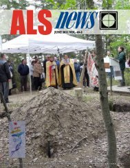
<strong>The</strong> Associaton staff held a farewell lunch<br />
for retiring Registrar Dick Bassil just<br />
before Christmas. Dick served as the Association’s<br />
registrar from 2003 to 2007.<br />
Executive Director Brian Munday is<br />
shown in the picture presenting Dick<br />
with an artist’s rendition of a map of the<br />
Howse Pass in commemoration of the<br />
David Thompson Bi-centennial.<br />
All of us thank Dick for the integrity<br />
and knowledge that he brought to the registrar’s<br />
position and the profession overall.<br />
We wish you well!<br />
16 . <strong>March</strong> 2008 ALS News
Historical Foundation Up And Running<br />
<strong>The</strong> <strong>Alberta</strong> Historical<br />
and Educational<br />
Foundation for <strong>Land</strong><br />
Surveying is not just a<br />
reality but has money in<br />
the bank.<br />
<strong>The</strong> AHEFLS was officially launched in<br />
late 2005, however some operational delays<br />
in becoming registered as a charitable<br />
organization delayed a formal fundraising<br />
and membership drive.<br />
<strong>The</strong> Foundation was originally<br />
conceived back in 2002 as a charitable<br />
foundation to raise funds to preserve the<br />
history of surveying and promote the<br />
profession through traveling displays in<br />
<strong>Alberta</strong> museums. Somewhat akin to<br />
the mandate of the ALSA Historical &<br />
Biographical Committee, the AHEFLS as<br />
a charitable organization will be able to<br />
issue tax receipts for donations of historic<br />
<strong>The</strong> <strong>Alberta</strong> Historical and Educational Foundation<br />
for <strong>Land</strong> Surveying will be holding its second annual<br />
meeting in conjunction with the ALS Annual<br />
Meeting at Lake Louise in April. All members of the<br />
ALSA are invited to attend and participate.<br />
survey equipment as well as cash contributions.<br />
<strong>The</strong> Foundation is set up with<br />
a similar corporate structure as the J. H.<br />
Holloway Foundation but does not plan<br />
to compete with the JHH for contributions.<br />
<strong>The</strong> AHEFLS is looking to obtain<br />
legacy grants as well as the donation of<br />
survey artifacts. <strong>The</strong> Foundation is also<br />
set up so that it can receive donations of<br />
shares which will give the donor significant<br />
relief from capital gains.<br />
<strong>The</strong> Foundation’s charter allows it to<br />
sell a maximum of 1,000 non-negotiable<br />
shares which are restricted to members of<br />
the <strong>Alberta</strong> <strong>Land</strong> <strong>Surveyors</strong>’ Association.<br />
<strong>The</strong>re are currently only three shareholders<br />
being the founding directors, Jim Halliday,<br />
Dave McWilliam and Ken Allred.<br />
<strong>Alberta</strong> <strong>Land</strong> <strong>Surveyors</strong> are invited to join<br />
up as shareholders of the Foundation.<br />
<strong>The</strong> AHEFLS has had discussions with<br />
the Historical & Biographical Committee<br />
of the ALSA to assess projects which<br />
the two bodies can move forward on a<br />
collaborative basis. Among the potential<br />
projects being discussed to date have<br />
been the David Thompson Centennial<br />
Canoe Brigade, traveling survey displays<br />
for smaller museums and the 100th Anniversary<br />
of the <strong>Alberta</strong> <strong>Land</strong> <strong>Surveyors</strong>’<br />
Association.<br />
<strong>The</strong> <strong>Alberta</strong> Historical and Educational<br />
Foundation for <strong>Land</strong> Surveying will be<br />
holding its second annual meeting in<br />
conjunction with the ALSA Annual Meeting<br />
at Lake Louise in April. All members<br />
of the ALSA are invited to attend and<br />
participate.<br />
At present, the Foundation is starting<br />
off small but hopes to work closely with<br />
the <strong>Surveyors</strong> Historical Society in the<br />
United States, working together to preserve<br />
and publicize the rich history that<br />
land surveying has played in the development<br />
of North America.<br />
<strong>The</strong> <strong>Surveyors</strong> Historical Society holds<br />
an annual rendezvous at various locations<br />
to commemorate significant events in survey<br />
history. Recent events have included a<br />
David Thompson rendezvous in Spokane<br />
in 2005, a tribute to George Washington<br />
in Virginia in 2006 and a Rendezvous<br />
on the Mason Dixon line in 2002. From<br />
September 11 to the 13th, the SHS will<br />
celebrate the birthplace of the Public <strong>Land</strong><br />
This is the birth of what<br />
<strong>Alberta</strong> <strong>Land</strong> <strong>Surveyors</strong><br />
will look back on as<br />
a significant stepping<br />
stone to acclaiming<br />
our place in the<br />
development of Western<br />
Canada.<br />
System in Akron, Ohio. A Museum of<br />
Surveying and park was created some<br />
twenty or so years ago in Lansing, Michigan<br />
and is now joined by a new National<br />
Museum of Surveying in Springfield Illinois, in the <strong>Land</strong><br />
of Lincoln, another of America’s great<br />
surveyor presidents.<br />
Perhaps one day the AHEFLS will be<br />
in a position to emulate our American<br />
colleagues in establishing a survey museum<br />
to display our proud history.<br />
<strong>The</strong> Foundation will also liaise with the<br />
FIG Permanent Institution for the History<br />
of Surveying and Measurement. <strong>The</strong><br />
FIG Institution continues to work with<br />
the United Nations to establish World<br />
Heritage sites commemorating significant<br />
survey achievements such as the Struve<br />
Arc through Europe and the north south<br />
longitudinal arc through Africa. A possible<br />
heritage site might be the Dominion<br />
<strong>Land</strong> Survey System in western Canada<br />
which has been acclaimed as the greatest<br />
engineering feat of all times. Perhaps we<br />
can change that to be the greatest surveying<br />
feat of all times.<br />
This is the birth of what <strong>Alberta</strong><br />
<strong>Land</strong> <strong>Surveyors</strong> will look back on as a<br />
significant stepping stone to acclaiming<br />
our place in the development of Western<br />
Canada.<br />
G. K. Allred, ALS<br />
ALS News <strong>March</strong> 2008 . 17
R.O. (Ron) Hall, ALS<br />
D.R. (Don) George, ALS<br />
FOR PRESIDENT<br />
R.O. (Ron) Hall, ALS<br />
Born in Calgary, <strong>Alberta</strong>.<br />
Received diploma in Surveying Technology from the Southern <strong>Alberta</strong> Institute of Technology<br />
(SAIT) in 1981.<br />
Received Bachelor of Science degree in Survey Engineering from the University of Calgary<br />
in 1987.<br />
Received <strong>Alberta</strong> <strong>Land</strong> Surveyor (ALS) commission in 1989 under the supervision of Len<br />
Leiman, ALS.<br />
Received Professional Engineer (P.Eng.) designation in 1989.<br />
Received commission as a Canada <strong>Land</strong> Surveyor (CLS) in 1991.<br />
Received MBA, with distinction, through the University of Calgary’s Haskayne School of<br />
Business in 2005.<br />
Began surveying career at Midwest Surveys in 1987 until 1993.<br />
In 1993 joined Focus Corporation and moved to Grande Prairie, 1993-2001.<br />
In 1996 was appointed Vice President of Focus’ Oil and Gas Surveys Division and in 2000<br />
was appointed to the position of President and COO of the organization.<br />
Ron has served on the Board of Directors of Focus Corporation since 1995.<br />
Currently, Ron holds the position of Executive Vice President–Geomatics.<br />
Ron is a member of the Focus Executive Leadership Team which oversees the management<br />
of the organization and its divisions.<br />
Involved in many ALSA committees including: acting as ALSA’s representative on the<br />
development of the MRA-2001, Chairman of the Registration Committee, sitting on<br />
Council, and serving as Vice President for 2007–2008.<br />
Also involved in other professional associations including the Canadian Institute of Geomatics<br />
(CIG), APEGGA, ACSM and the Association of Canadian <strong>Land</strong> <strong>Surveyors</strong> (ACLS).<br />
Resides in Cochrane, <strong>Alberta</strong> with wife Shirley and two teenage boys, Aaron and Matthew.<br />
FOR VICE PRESIDENT<br />
D.R. (Don) George, ALS<br />
Born in Edmonton, <strong>Alberta</strong>.<br />
Began surveying career in 1966.<br />
Received diploma in Survey Technology at NAIT in 1969.<br />
Articled to Hugo Engler and received ALS commission (#397) in 1975.<br />
Shareholder and manager of W.D. Usher and Associates (branch office) in Camrose in<br />
1975.<br />
Sold shares in W.D. Usher, bought assets and started Cam-Alta Surveys Ltd in 1984.<br />
Sold Cam-Alta Surveys Ltd. to Maltais Associates <strong>Surveyors</strong> Ltd. in 1993.<br />
Joined the ALSA January 1994 as Assistant to the Director of Practice Review.<br />
November 2007 became Acting Director of Practice Review and Assistant to the Acting<br />
Director of Practice Review until the present. Became my own boss, ha!!<br />
ALSA Activities<br />
Member of Council 1988 to 1990.<br />
Over the years, a member of various committees and sub-committees of the ALSA [Standards<br />
and sub-committees of Standards (13 years), Legislative, ALSA Liaison, to mention a<br />
few].<br />
Was a presenter at various seminars (Getting It Right, Evidence and Field Staff).<br />
Personal<br />
Hobbies are grandchildren, traveling, outdoor activities with my wife and our grandchildren<br />
and mentoring.<br />
Resides in Edmonton and married to my lovely wife Eileen.<br />
Five children and eleven fantastic grandchildren.<br />
Future goals are semi-retirement and involvement with the Executive of the ALSA.<br />
18 . <strong>March</strong> 2008 ALS News
nominees for council<br />
T.W. (Terry) Hudema, ALS, CLS, P.Eng.<br />
Born in Willingdon, <strong>Alberta</strong>; raised in Lethbridge.<br />
Graduated from the University of <strong>Alberta</strong> with a B.Sc. in Civil Engineering in 1971.<br />
Received Professional Engineer status in 1973.<br />
Articled to Jerald Rasmuson, ALS.<br />
Obtained ALS Commission in 1976.<br />
Received Canada <strong>Land</strong>s Surveyor Commission in 1982.<br />
Previously employed by JTR Survey Services Ltd., Government of <strong>Alberta</strong> (contract) and<br />
Stantec.<br />
Employed with Raymac Surveys Ltd. since 1998. Currently a partner and director.<br />
Served on numerous ALSA committees as a member, from 1976 to present including Standards,<br />
Legislation, Vision 2000, Discipline and Boundary Panel.<br />
Served as South Sub-Chairman on the rewrite of the <strong>Land</strong> <strong>Surveyors</strong> Act and Chairman<br />
of the Legislation Ad Hoc Committee Surveys Act Section 3 Monument Governing Status<br />
rewrite.<br />
Member of the ALSA Council since 2006.<br />
Council Liaison to Legislation Ad Hoc Committee (2006 and 2007) Future of the Association<br />
Ad Hoc Committee (2006) and Director of Surveys Review Committee (2007).<br />
Member of APEGGA and ACLS.<br />
Member of the <strong>Alberta</strong> Central Zone Referees Committee from 1979 to 1995. Instructor<br />
from 1988 to 1995.<br />
Off-ice official with the WHL Calgary Hitmen since 1995.<br />
Involved with Special Olympics Calgary, <strong>Alberta</strong> and Canada Floor Hockey program since<br />
2003.<br />
Leader on the 2003 ALSA Geomatics Award of Excellence presented to Raymac Surveys<br />
Ltd.<br />
Three adult children: Christopher, Nicole and Stephanie.<br />
T.W. (Terry) Hudema, ALS<br />
FOR COUNCIL<br />
J. (John) Haggerty, ALS, CLS, P.Eng.<br />
Born in Winnipeg, Manitoba in 1974.<br />
Graduated from U of C with a B.Sc. in Geomatics Engineering in 1997.<br />
Worked for Haggerty Surveys Ltd. (previously Diamond Willow Planning and Surveying<br />
Ltd.) from a young age.<br />
Has worked for Challenger Surveys Ltd., Stantec Geomatics, and the Regional <strong>Surveyors</strong><br />
Office of Geomatics Canada.<br />
Employed by Can-Am Geomatics Corp., 1997-present (Edmonton, Fort McMurray and,<br />
for the past 4 years, Grande Prairie).<br />
Served articles under Roger Ross, ALS, CLS and John Wallace, ALS.<br />
Obtained ALS Commission in 2003 and CLS Commission in 2007.<br />
Served on the Historical and Biographical Committee for four years and was involved in<br />
the research and editing of Laying Down the Lines.<br />
Served on the Registration Committee for the past three years.<br />
Vice president of the Grande Prairie Pipes and Drums. Further, he enjoys hunting, camping,<br />
and gardening.<br />
He and his wife, Elke, have two children, Emma(4) and Gordon(2), and live in Grande<br />
Prairie.<br />
J. (John) Haggerty, ALS<br />
ALS News <strong>March</strong> 2008 . 19
J.I. (Jim) Maidment, ALS<br />
J.J. (John) Matthyssen, ALS<br />
C.R. (Connie) Petersen, ALS<br />
J.I. (Jim) Maidment, ALS<br />
Born in Peterborough, Ontario in 1954.<br />
Attended Ryerson Polytechnical Institute 1971 to 1975.<br />
Employed by Horton & Wallace Surveys, Ontario, 1973 to 1979.<br />
Moved to Calgary in 1979.<br />
Employed by Sunbow Consulting, 1979 to 1992.<br />
Articled to Ed Lyster and received ALS commission in 1986.<br />
Founder and Manager of Maidment <strong>Land</strong> Surveys Ltd. 1992 to present.<br />
Extensive experience in most areas of municipal surveying with a couple of years<br />
working in the “oil patch.”<br />
Served on various ALSA ad hoc committees including RPR and Co-ordinate Based<br />
Cadastre.<br />
Served for many years on the Registration Committee.<br />
Hobbies include biking, sailing, canoeing, and traveling.<br />
Married 29 years to Joan with two grown children; Greg & Lisbeth.<br />
J.J. (John) Matthyssen, ALS, CLS<br />
Born in St. Thomas, Ontario in 1957.<br />
Began surveying in 1976.<br />
Graduated from the University of Toronto, Erindale College Survey Science Program<br />
in 1980.<br />
Articled to Kirk White, ALS 1981 to 1983.<br />
Received ALS commission in January 1984.<br />
Received CLS commission in April 1988,<br />
Employed by Loeppky Matthyssen & Assoc. Ltd. from 1981 to 1997.<br />
Extensive experience in municipal construction, subdivision and condominium surveys.<br />
Currently employed by Focus Surveys L.P., successor to Cadastral Group Inc., 1997 to<br />
present.<br />
Extensive experience in oilfield, wellsite, pipeline and facilities in patented and Crown<br />
lands.<br />
Served on several ALSA committees including: Registration, Public Relations, Standards,<br />
Boundary Panel.<br />
Enjoys tennis, golf, skiing and boating.<br />
Resides in Calgary with wife Shannon and two teenage sons; Ryan and Kyle.<br />
C.R. (Connie) Petersen, ALS<br />
Born in New Denmark, New Brunswick.<br />
Received Geomatics Engineering degree from University of New Brunswick 1977.<br />
Member of APEGGA since 1981.<br />
Articled to J. Keith Smith, Vince Ziegler and Irwin Maltais.<br />
Received <strong>Alberta</strong> <strong>Land</strong> Surveyor commission in 1998.<br />
Employed in the survey industry in Nova Scotia, <strong>Alberta</strong>, British Columbia and Virginia<br />
from 1977-2004.<br />
Documents examiner at Edmonton <strong>Land</strong> Titles Office in 1983-1986.<br />
Branch Manager for Maltais Geomatics in High Level from 1997-2000.<br />
Served as High Level Town Councillor 1999-2000.<br />
Member of Lethbridge Home Builders Association executive 2002-2003.<br />
Currently employed by Midwest Surveys Inc. in Brooks and Medicine Hat.<br />
Served on Legislation Committee 1997-2001.<br />
Chairman of Legislation Committee 1999-2001.<br />
Served on CPD Subcommittee 1997-1998.<br />
Served on Association Finances Ad Hoc Committee 2000-2001.<br />
Served on Registration Committee 2001 to present.<br />
Chairman of Registration Committee 2005-2006.<br />
Hobbies include golf and travel.<br />
20 . <strong>March</strong> 2008 ALS News
Multimedia Data<br />
As Boundary Determination Evidence In <strong>Alberta</strong><br />
In June-July 2007, I sent out a<br />
questionnaire to land surveyors in<br />
<strong>Alberta</strong> which explored the use of<br />
cameras and videos as part of the<br />
data gathering process in cadastral surveys.<br />
Unfortunately only four questionnaires<br />
were returned, but, unsurprisingly a<br />
number of land surveyors were more than<br />
willing to discuss the issue informally.<br />
It appears that a significant number of<br />
field crews performing cadastral surveys in<br />
<strong>Alberta</strong> carry digital cameras and use them<br />
to record evidence related to boundaries.<br />
One surveyor indicated that, at times,<br />
his company’s crews use video cameras or<br />
still shots on their cell phones to transmit<br />
evidence to the land surveyor in the<br />
office and discuss and assess the different<br />
evidence before them with the office while<br />
they are in the field before making a decision<br />
on the most probable position of the<br />
boundary or monument in question.<br />
As with all electronic evidence, this<br />
creates a number of interesting dilemmas.<br />
First, the land surveyor has visual and<br />
audio evidence available which a few years<br />
ago perhaps would not have been readily<br />
available. Moreover, in the case of images<br />
transmitted by cell phone, the dialogue<br />
assisted by imagery permits informed<br />
decisions to be made while the crew is<br />
in situ. It can be expected that these new<br />
tools should reduce the instances where<br />
poor judgement is made regarding the<br />
most probable position of a boundary.<br />
Challenges arise as to the admissibility<br />
of this form of data in the event of<br />
court action. I should emphasize the<br />
greater weight of circumstantial evidence<br />
available, the lower the chance of a case<br />
appearing in court. This is especially so if<br />
the mathematical evidence derived from<br />
survey observations is combined with<br />
imagery of the physical evidence available<br />
and the different items of data collectively<br />
suggest the same conclusion about the<br />
most likely position of a boundary. In<br />
any event, land surveyors should employ<br />
standards of practice which would make<br />
court action an extremely unlikely event.<br />
Consider the example of a search and<br />
possible replacement of a lost monument.<br />
Images of existing fence positions in the<br />
same frame(s) as holes dug to search for<br />
evidence of the monument as predicted<br />
from mathematical evidence, along with<br />
the audio record of the discussion between<br />
the land surveyor and the field crew<br />
should provide an idea of the zone of uncertainty<br />
which exists about the position<br />
of the monument.<br />
It is, of course, trite that exact boundaries<br />
or edges exist only in geometrical<br />
theory. In practice, a zone of uncertainty,<br />
or fuzzy zone, exists even if the original<br />
monuments are in position, as the monuments<br />
may have been disturbed or in the<br />
case of large monuments (e.g. mounds,<br />
cairns, stone blocks), it may not be certain<br />
if the centre or one of the edges of the<br />
monument defines the original boundary<br />
or if the monument has eroded or<br />
weathered unevenly. This zone of uncertainty<br />
may be amplified considerably<br />
when the monuments are lost and have to<br />
be replaced based on an evaluation of the<br />
evidence available.<br />
...in the case of images transmitted by cell<br />
phone, the dialogue assisted by imagery permits<br />
informed decisions to be made while the crew is<br />
in situ...these new tools should reduce the instances<br />
where poor judgement is made regarding<br />
the most probable position of a boundary.<br />
In the event that a case does come<br />
before the court, the problem of admissibility<br />
of evidence arises. <strong>The</strong> issue of<br />
video evidence and admissibility has been<br />
covered in depth in an article by Oliver<br />
MacLaren and me in ALS News of June<br />
2007. Historically, the surveyor’s documented<br />
field notes should be available<br />
in an unaltered form for inspection and<br />
investigation long after the surveyor has<br />
passed on. If we adhere to this maxim,<br />
then ideally the audio record of the cell<br />
phone discussion and the accompanying<br />
video or still photos should form part of<br />
the evidence before the court. This data<br />
should form part of the survey record, and<br />
be stored in a manner which would satisfy<br />
the court that it has not been altered from<br />
its original form, or at least not altered so<br />
that meaningful evidence has been omitted<br />
or the emphasis or meaning of the<br />
whole multimedia record (photographs,<br />
audio files, video clips) has changed.<br />
Counsel for both parties should be able to<br />
promote or challenge the admissibility of<br />
this evidence.<br />
Perhaps what the literature has not<br />
examined to date is what might have been<br />
omitted from a video or discussion. Digital<br />
video files use an enormous amount<br />
of storage space. My experience of using<br />
evidence to record claims to land rights<br />
in a number of situations is that practically<br />
one has to keep the use of video to a<br />
minimum. This means that one may omit<br />
discussion which might be important.<br />
Very important items of evidence may be<br />
mentioned as an aside outside of a formal<br />
interview when the camera is not running.<br />
Nowadays, I record an audio track from<br />
the start to the finish of the process without<br />
any breaks as audio on its own creates<br />
a far smaller digital file.<br />
Dr. Michael Barry<br />
University of Calgary<br />
ALS News <strong>March</strong> 2008 . 21
MORE CAPABILITIES<br />
TDS NOMAD<br />
MORE POWER<br />
BACKLIT NUMERIC KEYPAD SURVEY PRO SOFTWARE INTEGRATED WIRELESS VIBRANT SCREEN<br />
Nomad... Built for you.<br />
<strong>Land</strong> surveyors know what they want from a cutting edge data<br />
collector, so TDS engineers went to work to create the next TDS<br />
data collector with those priorities in mind.<br />
<strong>The</strong>y nailed it. <strong>The</strong>n they took it a step further.<br />
√ Vibrant screen—stands up to bright sunlight<br />
√ Backlit numeric keypad for easy viewing in dim light<br />
√ Fastest processor on the market—806 MHz<br />
√ Wireless connectivity—Bluetooth and 802.11<br />
√ Powerful Memory—128 MB SDRAM, up to 1GB Flash<br />
√ Integrated GPS—use with Survey Pro GeoLock<br />
√ Battery life that keeps up with your workload<br />
√ Ruggedness that stands up to the harshest environments<br />
√ Survey Pro—Version 4.5 with enhanced features<br />
√ CF & SDIO slots for even more functionality<br />
√ Windows Mobile 6—latest operating system for mobile devices<br />
Is it hard to imagine all that power in the palm of your hand and<br />
weighing just 21 ounces? You don’t have to imagine—it’s reality.<br />
Nomad. More capabilities. More power.<br />
See your TDS Dealer to learn<br />
more about putting Nomad<br />
to work for you.<br />
tdsway.com/4Nomad<br />
©2007 Tripod Data Systems, Inc. All rights reserved.
Relating GPS Baselines<br />
to “Ground” Distances<br />
and Bearings<br />
Surveys incorporating GPS (and particularly RTK) derived<br />
information are today commonplace. However, despite<br />
the widespread use of GPS-derived information, there<br />
has been little Association-wide discussion with regards<br />
to how to appropriately use this information on a plan of survey.<br />
Instead, individual practitioners usually rely on procedures provided<br />
to them by equipment and software suppliers which are not<br />
necessarily optimal for surveying in <strong>Alberta</strong>. This article discusses<br />
how to transform GPS-derived data into “plan-ready” bearings<br />
and distances and provides a standard that allows surveyors to<br />
directly compare their work.<br />
GPS processing, whether via RTK or post-processing, is<br />
intrinsically done in the WGS-84 reference frame. <strong>The</strong> resulting<br />
baseline vectors can be considered “pseudo-observations” in a<br />
subsequent adjustment, relating coordinate differences between<br />
observed points in WGS-84 (i.e. [dx dy dz]). For the rest of this<br />
article, we will use the term “GPS observation” to actually mean<br />
these baseline vectors, rather than the raw observations (satellite<br />
ranges) themselves.<br />
Given a set of points tied together via GPS observations, the<br />
coordinates of these points can be rigrously determined in the<br />
WGS-84 reference frame. Note that under normal surveys, the<br />
coordinates of one or more points in the network must be known<br />
to establish a datum. In special circumstances, the coordinates<br />
of the points may be determined directly, for example using<br />
NRCan’s Precise Point Positioning service. It is important to bear<br />
in mind that when using RTK or DGPS, the coordinates of the<br />
receiver points are NOT directly observed via GPS, but rather,<br />
the inter-receiver coordinate differences are the observables and<br />
the coordinates are subsequently derived based on applied datum<br />
constraints (i.e. the assumption of a coordinate for at least one<br />
point in the network).<br />
As an aside, one should be aware that some knowledge of the<br />
location of the network is actually required for the processing<br />
of the raw observations (i.e. to solve the baselines), but that the<br />
results are only weakly dependent on the inital assumptions about<br />
the position of the network. If you took a set of GPS observaby<br />
Dr. Robert Radovanovic, ALS<br />
Author’s Note:<br />
This article was created at the SarWiki site (www.sarpigroup.com/<br />
sarwiki). This site is a repository of survey-related articles and workspaces.<br />
Anyone can join and then contribute to articles and projects<br />
on the site. In particular, the site features discussion groups that may<br />
be of use to surveyors and articled students on topics ranging from<br />
using GPS to studying for professional exams.<br />
tions located near<br />
Taber, and fixed a<br />
coordinate of one<br />
point such that it<br />
was incorrect by<br />
100 metres, the<br />
resulting baseline<br />
vectors would<br />
still be correctly<br />
calculated within<br />
a few millimetres.<br />
However, if you<br />
said the network<br />
was near Peace<br />
River, errors in<br />
even the relative<br />
quantities would<br />
result. Suffice it<br />
to say that using<br />
the automomous<br />
(i.e. handheldderived)<br />
position<br />
of a single reciever<br />
will allow<br />
processing of the<br />
baselines to sufficient<br />
surveying<br />
accuracies. Once<br />
the baselines are<br />
Important Note<br />
Regarding Base Initialization<br />
Although the coordinates of the base station only<br />
have to be roughly determined for correct relative<br />
baseline quantities to be calculated, gross errors (><br />
100 m) in the base station position will cause even<br />
the relative baseline quantities to be incorrect.<br />
Usually, an autonomous receiver position at<br />
the base (i.e. the “here” solution) is sufficient for<br />
everything to work fine. However, sometimes the base<br />
station will determine a hugely incorrect position for<br />
itself (elevations of -3000m inside the earth, latitude/<br />
longitudes in other countries, etc). This usually happens<br />
if the base station is suddenly turned off without<br />
properly ending survey (i.e. power is pulled) and the<br />
base station is restarted at a different job. This behaviour<br />
has been detected in Leica and Trimble systems.<br />
Unless you check the base station position when<br />
you start the day and confirm it is “reasonable” you<br />
might go about your day surveying and incurring<br />
a huge (>100 ppm) scale factor error that is totally<br />
undetectable unless you compare to prior surveys, or<br />
set up the base station in a different spot and re-tie<br />
in points. During this doomed survey, the base will<br />
show it is properly tracking satellites, and the rover<br />
will fix ambiguities and show decent quality control<br />
results. <strong>The</strong> only hint something is amiss MAY be a<br />
“Reference Coordinates Differ from Expected” message.<br />
NEVER pull the plug on the base station to turn<br />
it off and ALWAYS confirm that the base station is<br />
using a reasonable (within 20 m) coordinate for itself.<br />
This can be done with a handheld receiver, using the<br />
ATS fabric to calculate a rough lat/long for the point<br />
the base is set over, or even using a NTS map.<br />
determined, they can be directly translated to “better” known<br />
coordinates.<br />
Since coordinates can be rigorously transformed between<br />
WGS-cartesian and WGS-lat/long/height formats, it makes no<br />
difference whether the results of GPS processing are presented as a<br />
set of WGS-84 cartesian coordinates or latitude/longitude/height<br />
triplets. Indeed, even mapping plane coordinates can be considered<br />
“complete,” if map projection parameters are provided. From<br />
an adjustment perspective, the cartesian solution is best, but from<br />
a semantic perspective, map projection results are more understandable.<br />
It’s tough to have a “feeling” of what a vector of [640 x,<br />
240 y, 300 z] looks like in the WGS-84 frame, but “390 N, 635 E<br />
and 40 up” makes some sort of physical sense.<br />
In the case of land surveying, arbitrary bearings are shown<br />
on a survey plan, along with “ground distances.” <strong>The</strong> concept of<br />
“ground distance” is ambiguous, as it implies a constant refer-<br />
ALS News <strong>March</strong> 2008 . 23
ence surface for the entirety of the survey.<br />
This poses a problem even for terrestrial<br />
surveys, as demonstrated in the diagram<br />
below. Assume that three stations are<br />
set up in a direct line. Each station is at<br />
significantly different elevation and interstation<br />
distances are measured. We will assume<br />
that no atmospheric effects exist and<br />
that there are no error sources present in<br />
the results. <strong>The</strong> stations are arranged such<br />
that the distances on the ellipsoid between<br />
stations A and B, and B and C are exactly<br />
3 km. Since the measurements are perfect,<br />
the distance on the ellipsoid between A<br />
and C is exactly 6 km.<br />
If one would like to represent the<br />
measured distances on a plan of survey, it<br />
will become quickly evident that a single<br />
reference surface is required to be defined<br />
or else artifical (and purely compuational)<br />
misclosures will be introduced. <strong>The</strong> choice<br />
of this reference surface is completely<br />
arbitrary to the surveyor. Furthermore, if a<br />
subsequent surveyor attempts to replicate<br />
this experiment, they will come up<br />
with different results unless they use the<br />
same choice of reference surface. In the<br />
diagram above, Surveyor A could assume<br />
the 300 metres level is ground, and say<br />
the distance from A to C is 6.0 km + 28<br />
cm. Surveyor B could then replicate the<br />
survey, assume 900 m is ground and come<br />
up with 6.0 cm + 84 cm. Neither is right,<br />
neither is wrong, but Plan A does not<br />
correspond to Plan B (granted, they do<br />
within 1:5000, but that is a poor example<br />
of sweeping today’s problem under the<br />
1960s rug).<br />
A similar issue arises in the use of<br />
GPS-derived observations since the<br />
baselines are fundamentally line-of-sight<br />
24 . <strong>March</strong> 2008 ALS News<br />
observations. A common reference surface<br />
must be defined for all projects in an area<br />
or discrepancies will become evident.<br />
Although these discrepancies are small<br />
(a 10 m change in elevation would alter<br />
the reduced distance of a 10 km line by<br />
2 cm), they are certainly within the accuracies<br />
achievable and ranges utilized for<br />
conventional GPS.<br />
<strong>The</strong> simplest reference surface to use<br />
would be the ellipsoid. However, due<br />
to the requirements for survey plans to<br />
indicate “ground distances,” this is not<br />
appropriate. Instead, a solution is to<br />
break up the province into townships over<br />
which a particular map projection applies.<br />
Since GPS observations can be direcly<br />
and consistently transformed between<br />
WGS-84 and any given map projection,<br />
surveyors would be able to directly compare<br />
observations and derived quantities<br />
such as the bearing and distance between<br />
two surveyed points.<br />
An appropriate map projection to use<br />
would be a modified transverse mercator<br />
projection with a latitude and longitude of<br />
origin corresponding to the latitude and<br />
longitude of the NE 33 of the township.<br />
This would immediately result in derived<br />
bearings referred to the central meridian<br />
of the township, thus being very similar<br />
to bearings expected from past work based<br />
on original township surveys. This map<br />
projection would also closely approximate<br />
the design of unsurveyed territory.<br />
Rigorously, a proper survey would require<br />
a direct occupation of the NE 33 to<br />
determine its latitude and longitude and<br />
ties from this point to the survey would<br />
be made. However, simply using the ATSderived<br />
latitude/longitude of the NE 33<br />
and ensuring that the relative position of<br />
the survey network with respect to the NE<br />
33 is known within 20 metres (achievable<br />
via the single-point solutions of the<br />
receivers) will result in a properly-rotated<br />
network. If the NE33 is directly tied at a<br />
later date, coordinates can be appropriately<br />
translated.<br />
A consistent scale factor can be derived<br />
for the “township tiles” by assuming an<br />
average elevation for the township, derived<br />
from an appropriate DTM. In this<br />
case, we have derived such elevations using<br />
the results of the Space Shuttle Topography<br />
Mission, and sampling 144 points<br />
per township. Even in the foothills, where<br />
elevations can change significantly over a<br />
township, use of the average elevation is<br />
suitable, since what we are seeking to do is<br />
provide a consistent reference surface for<br />
the comparison of GPS observations. If a<br />
GPS baseline is then compared to a terrestrial<br />
survey, a discrepancy will exist, but<br />
the amount of the error will usually below<br />
the typical terrestrial surveying accuracy.<br />
<strong>The</strong> resulting map projection parameters<br />
for each township within <strong>Alberta</strong> is<br />
available as an excel spreadsheet available<br />
at the SarWiki site (www.sarpigroup.com/<br />
sarwiki) in the forums section under the<br />
topic of “GPS and Geodesy Issues.” <strong>The</strong><br />
lat/long of the NE 33 of every township<br />
in <strong>Alberta</strong> is provided, as well as a scale<br />
factor to use for every township.<br />
By using these projections, one can set<br />
up appropriate mapping tiles for use with<br />
RTK or static GPS operations. <strong>The</strong> significant<br />
advantage of this process is that, if all<br />
surveyors use the same tiles, surveys can<br />
be directly compared for distances AND<br />
bearings (as opposed to distances and<br />
angles). A simple notation in the affidavit<br />
that “all bearings are derived from GPS<br />
and are referred to the central meridian<br />
of Township xx, Range xx, WxM” is sufficient<br />
to allow rigorous comaprisons of<br />
results. This system also greatly facilitates<br />
the building of “survey databases” within<br />
a surveyors’ own operations. In addition,<br />
in the field, if all the required projections<br />
are loaded on a data collector, an operator<br />
simply has to specify the township,<br />
range and meridian they are operating in<br />
and the datum used will automatically<br />
correspond to prior surveys in the area.<br />
A single known coordinate is all that is<br />
required for complete consistency with<br />
prior surveys.<br />
•
ook review<br />
So here I am, between Christmas<br />
and New Years, trying not to<br />
think about work. It had been a<br />
busy fall at the ALSA office and<br />
I was looking forward to some relaxing<br />
time coaching my son’s hockey team in a<br />
local tournament (his team won gold by<br />
the way). So one day, I went to my local<br />
Chapters store to pick out a new book so<br />
I could spend much of my break reading<br />
and relaxing. As I go up and down<br />
the aisles trying to decide between this<br />
book or that one, I came across Arc of<br />
the Medicine Line: Mapping the World’s<br />
Longest Undefended Border Across the<br />
Western Plains by Tony Rees. So much for<br />
not thinking about surveying during my<br />
Christmas holidays.<br />
Arc of the Medicine Line tells the story<br />
of Canadian, British and American surveyors<br />
undertaking one of the largest surveying<br />
jobs ever in all of North America.<br />
From 1872 to 1874, “they endured snow<br />
storms, mosquitoes, flash floods and the<br />
seething tensions from the aftermath of<br />
the US Civil War, the Metis uprising and<br />
the ongoing Indian Wars, all the while<br />
mapping and placing markers across<br />
nearly 900 miles of unforgiving territory.<br />
In drawing the ‘Medicine Line’ they<br />
defined the final shape of a new nation<br />
and ended, once and for all,<br />
the old American dream of<br />
Manifest Destiny.”<br />
I had the opportunity<br />
to read and learn about<br />
the surveying of the 49th<br />
Parallel when Judy Larmour<br />
was researching and writing<br />
Laying Down the Lines for<br />
the Association. In Tony<br />
Rees’ book, he expands on<br />
the story into a 370-page<br />
book. Arc of the Medicine<br />
Line is not a technical book<br />
focusing on how the surveys<br />
were done or what kind<br />
of equipment was used.<br />
Instead, Tony Rees gives<br />
life to the characters and<br />
shows what their personalities<br />
were like, both good<br />
and bad. Captain Donald<br />
Cameron was Chief Commissioner<br />
of the British and<br />
Canadian contingent but<br />
it appears that he was appointed<br />
based on his political<br />
and social connections rather than any<br />
experience as a surveyor. He apparently<br />
brought his wife and family with him to<br />
these wild outposts and would occasionally<br />
go on picnics with his family rather<br />
than attend to the surveying work at<br />
hand. Accompanying Cameron was Chief<br />
Astronomer Samuel Anderson who is<br />
described in the book as relaxed and congenial,<br />
popular and well-respected who<br />
would ask a great deal of his men and they<br />
would rarely disappoint him. Another<br />
prominent character in Arc of the Medicine<br />
Line is Lieutenant Albany Featherstonhaugh.<br />
Lieutenant Featherstonehaugh is<br />
described as a quiet and reserved man but,<br />
“more than once Anderson would note his<br />
colleague’s ‘irritable’ manner.”<br />
I am presuming that the Canadian and<br />
British records for this survey work were<br />
better preserved as Tony Rees does seem<br />
to give more time giving more life to the<br />
British and Canadian characters than to<br />
the American ones.<br />
Tony Rees himself was born in the<br />
United Kingdom and came to Canada in<br />
1957. He has an MA in English Literature<br />
from the University of Western Ontario<br />
(my alma mater) and was supervisor of<br />
the City of Toronto Archives before moving<br />
west to become Calgary’s first city<br />
ISBN 13:978-1-55365-278-6<br />
Arc of the Medicine<br />
Line tells the story of<br />
Canadian, British and<br />
American surveyors<br />
undertaking one of<br />
the largest surveying<br />
jobs ever undertaken<br />
in all of North<br />
America.<br />
archivist in 1981. Mr. Rees was on the organizing<br />
committee for the 1988 Calgary<br />
Winter Olympic Games and was chief<br />
archivist at the Glenbow Museum until<br />
1993 when he took to writing books. Rees<br />
is also the author of Hope’s Last Home:<br />
Travels in Milk River Country and Polo:<br />
<strong>The</strong> Galloping Game.<br />
A few years ago, I had the opportunity<br />
to do a presentation to some young<br />
home-schooled students. I gave them an<br />
unmarked map of North America and<br />
asked them to draw <strong>Alberta</strong>’s boundaries<br />
and it was fun to see what the results were.<br />
When someone gives you a map showing<br />
the boundaries of <strong>Alberta</strong> or Canada, it<br />
seems “obvious” that that is where they<br />
are and where they should be. When they<br />
are not marked on the map and certainly<br />
when they are not marked on the land,<br />
it is “obvious” how difficult the problem<br />
really is.<br />
“<strong>The</strong> logistical challenge in organizing<br />
men and material involved in the<br />
apparently simple act of drawing a thin<br />
line across 49 degrees north was becoming<br />
clear. For the 1873 season, her Majesty’s<br />
Commission would deploy a total of<br />
270 men, including 18 officers and 23<br />
non-commissioned officers and staff.<br />
<strong>The</strong>y would move with the aid of 100<br />
horses, 59 ponies and 48 oxen pulling 112<br />
vehicles of every sort and size.”<br />
Arc of the Medicine Line was not what<br />
I had intended to buy when I walked into<br />
my local bookstore but it was a great book<br />
to read over the Christmas holidays and<br />
into the New Year.<br />
Brian Munday<br />
ALS News <strong>March</strong> 2008 . 25
TOTAL STATIONS<br />
NIKON<br />
DTM-522<br />
$<br />
7,895 .00<br />
00-0522<br />
<br />
<br />
<br />
<br />
<br />
<br />
<br />
<br />
<br />
<br />
<br />
<br />
<br />
<br />
<br />
<br />
<br />
<br />
<br />
<br />
<br />
<br />
NIKON<br />
NPL-362<br />
$<br />
8,295 .00<br />
00-0362<br />
<br />
<br />
<br />
<br />
<br />
<br />
<br />
<br />
<br />
NIKON<br />
NPL-632<br />
$<br />
9,750 .00<br />
00-0632<br />
GST not included. Prices subject to change without notice<br />
GST not included. Prices subject to change without notice
RANGER<br />
<br />
<br />
<br />
<br />
<br />
<br />
<br />
<br />
<br />
<br />
<br />
Survey Standard ........................... <br />
Survey Pro ....................................... <br />
Survey Pro, GPS or Robotic ....... <br />
NOMAD<br />
<br />
<br />
<br />
<br />
<br />
<br />
<br />
<br />
<br />
<br />
<br />
<br />
<br />
Survey Standard ........................... <br />
Survey Pro ....................................... <br />
Survey Pro, GPS or Robotic ....... <br />
<br />
Survey Standard ........................... <br />
Survey Pro ....................................... <br />
Survey Pro, GPS or Robotic ....... <br />
RECON<br />
<br />
<br />
<br />
<br />
<br />
<br />
<br />
<br />
<br />
<br />
<br />
Survey Standard ........................... <br />
Survey Pro ....................................... <br />
Survey Pro, GPS or Robotic ....... <br />
GST not included. Prices subject to change without notice<br />
GST not included. Prices subject to change without notice
Pacific Crest<br />
Rover Radio<br />
Pacific Crest PDL Base Radio<br />
<br />
<br />
<br />
<br />
<br />
<br />
<br />
<br />
$1,195.00<br />
$1,795.00 <br />
<br />
Pacific Crest<br />
Repeater Radio<br />
<br />
<br />
<br />
<br />
<br />
$1,295.00<br />
<br />
Batteries<br />
Trimble Lithium<br />
Battery for<br />
Trimble 5700/5800<br />
$67.95<br />
<br />
Repeater<br />
Power<br />
Cable<br />
Includes 5m<br />
extension<br />
$119.95<br />
<br />
Cable<br />
Trimble TSC-1<br />
to 4700<br />
or 5700 Cable<br />
$229.95<br />
<br />
GPS/Radio<br />
Cable<br />
Base Radio to GPS<br />
Leica, Trimble<br />
or Topcon GPS<br />
$189.95<br />
<br />
Whip Antenna<br />
Pole Mount<br />
8’ ...... $149.95<br />
<br />
16’ ... $179.95<br />
<br />
Tripod-Mounted<br />
Repeater Battery<br />
12 AH<br />
Includes Charger<br />
$289.95<br />
<br />
5db Radio<br />
Antenna<br />
High Gain<br />
Mobile Whip<br />
$119.95<br />
<br />
Power House 12 Volt Base<br />
Battery & Charger<br />
<br />
Battery ..... $ 269 .95 <br />
Charger .... $ 179 .95<br />
<br />
Pacific Crest<br />
Radio Antenna<br />
Tripod<br />
Extends to 15’<br />
$199.00<br />
<br />
Unity Gain<br />
Radio<br />
Antenna<br />
Moderate Gain<br />
Mobile Whip<br />
$89.95<br />
<br />
GST not included. Prices subject to change without notice<br />
GST not included. Prices subject to change without notice
PIN FINDER<br />
TRADE-IN SPECIAL<br />
Includes Case<br />
Schonstedt GA-52Cx $849.00 Regular Price<br />
LESS TRADE-IN $125.00<br />
$724.00 06-6000<br />
Includes Holster<br />
Schonstedt<br />
GA-92XTI $975.00 Regular Price<br />
LESS TRADE-IN $125.00<br />
$850.00 06-6002<br />
THE<br />
THUNDERBOLT<br />
Stake driving tool ................... $189.00<br />
51-2006<br />
51-2009 $39.95<br />
51-2007 $56.95<br />
Metrotech 810 Line Tracer<br />
Now in stock<br />
$2,995.00<br />
06-8010<br />
Includes Case<br />
Schonstedt GA-72Cd $949.00 Regular Price<br />
LESS TRADE-IN $125.00<br />
$824.00 06-6001<br />
Metrotech<br />
810DX Line Tracer<br />
Now in stock<br />
Includes<br />
Battery Pack<br />
$3,195.00<br />
06-8000<br />
Pinpuller<br />
Pull survey pins with ease,<br />
even in frozen ground<br />
Now in stock<br />
$249.95<br />
51-2020<br />
Ox-Head Axe<br />
<br />
<br />
$79.95<br />
51-1001<br />
GST not included. Prices subject to change without notice<br />
GST not included. Prices subject to change without notice
At IHS, we provide<br />
the landscape of the<br />
Canadian oil and gas<br />
industry.<br />
IHS provides the most complete and accurate crown and detailed<br />
freehold land database in Canada.<br />
With over 50 years of data accumulation for Freehold, Open and<br />
Disposed Crown, First Nations and Dominion <strong>Land</strong>s, the IHS <strong>Land</strong><br />
dataset is the most trusted and comprehensive within the<br />
Canadian oil and gas industry.<br />
With daily auditing procedures, the IHS <strong>Land</strong> dataset ensures<br />
quality and completeness to provide you with the most reliable,<br />
comprehensive and high-quality data for your business.<br />
See for yourself. Call your Account Executive at 403 770 4646<br />
for more information.<br />
See further. See opportunity. See clearly.<br />
IHS is very proud to announce<br />
that it is being recognized as one<br />
of the “Best Workplaces in Canada”<br />
for 2007.<br />
403 770 4646<br />
www.ihs.com/energy<br />
©2007 IHS Inc. All Rights Reserved.
the keeper of<br />
lost records<br />
by andreas n. korsos<br />
Introduction<br />
Working on several projects related<br />
to the travels of David Thompson,<br />
it seemed natural to also reflect<br />
on another historic figure that may be<br />
considered a ‘forgotten’ explorer and<br />
trader. Simon Fraser’s 2008 bicentennial<br />
is quickly approaching, marking his<br />
successful descent of what is now known<br />
as the Fraser River, aptly named by David<br />
Thompson well after the event.<br />
Few exploits of exploration in Canadian<br />
history surpass Simon Fraser’s journey<br />
to the sea and back in 1808 and while<br />
rediscovering this remarkable expedition,<br />
it became clear that there is a connection<br />
between David Thompson and Simon<br />
Fraser that, to date, has not been recognized<br />
or fully studied.<br />
It is well known that Thompson<br />
explored, surveyed and mapped more of<br />
this continent than any other surveyor<br />
or mapmaker of his time. He has been<br />
depicted as a versatile individual, and has<br />
been often described as a writer, surveyor,<br />
scientific explorer, cartographer, naturalist<br />
and a fur trader. However, as a result of<br />
an indirect link to Fraser’s 1808 expedition,<br />
Thompson can be heralded for yet<br />
another accomplishment that not even he<br />
could have been aware of.<br />
Simon Fraser<br />
Descended from a noble Scottish Highland<br />
clan, Simon Fraser’s family fled to<br />
Canada in 1784 with thousands of other<br />
loyalists, following the conclusion of the<br />
American Revolution. After the loss of his<br />
father, Fraser’s family moved to Montreal<br />
where Fraser would eventually attend<br />
school and soon after, begin his career in<br />
the fur trade apprenticed to the North<br />
West Company in 1792. By 1799, Fraser<br />
was serving as a clerk at Fort Chipewyan,<br />
28 . <strong>March</strong> 2008 ALS News<br />
in the Athabasca Department, and by<br />
1801, he became a partner of the North<br />
West Company; no small feat for a man<br />
of only 25 years of age.<br />
Figure 1: Simon Fraser 1776–1862 (BC Archives)<br />
Over the Mountains<br />
Explorations as early as the 17th century<br />
along the Pacific coast had found<br />
the mouth of a large river near the 46th<br />
latitude, but it wasn’t until May of 1792<br />
that Captain Robert Gray, an American,<br />
actually entered the mouth and named it<br />
the Columbia River. Following Mackenzie’s<br />
exploration to the Arctic Ocean in<br />
David Thompson Taking an Observation, C.W. Jefferys, C.W. Jeffery<br />
fonds, Library and Archives Canada<br />
1789 and his successful breakthrough to<br />
the Pacific Ocean at Bella Coola in 1793,<br />
the North West Company took a serious<br />
interest in the prospects for trading furs in<br />
the Far East.<br />
Finding an overland route to the Pacific<br />
would enable the company to shorten<br />
the distance to the Far East by establishing<br />
a fort from which to ship their furs from<br />
so that they may trade for other more<br />
precious commodities more economically.<br />
Mackenzie’s route had taken him over the<br />
upper portion of what is today’s Fraser<br />
River and maps of the Pacific coast created<br />
shortly afterward included Mackenzie’s<br />
route, referring to the upper portion of<br />
that river as, among other names, the<br />
Columbia River (Figure 2). It was clearly<br />
thought that the upper portion of the<br />
Fraser River was the headwaters of the<br />
Columbia River.<br />
While many were deliberating whether<br />
the two rivers were connected, Mackenzie’s<br />
explorations overland were followed<br />
by expeditions along the eastern slopes of<br />
the Rocky Mountains by the great surveyor<br />
and pathfinder David Thompson,<br />
together with his North West Company<br />
partner Duncan McGillivray, in 1800<br />
and 1801 with little success. Simon Fraser<br />
was ultimately instructed to determine
whether the upper portion of the river<br />
that now bears his name was in fact the<br />
headwaters of the Columbia, and he<br />
began his attempts in the autumn of 1805<br />
which culminated with the 1808 expedition.<br />
Mapping Simon Fraser’s<br />
Expedition<br />
While researching Fraser’s movements<br />
from 1805-1808 in order to create a<br />
thematic map on the topic, a number of<br />
different sources were utilized, including a<br />
transcript of Fraser’s original journal and<br />
a version edited by W.K. Lamb in 1960.<br />
Through Lamb’s edits, it became clear that<br />
Simon Fraser relied heavily on his invaluable<br />
lieutenant, John Stuart, who played a<br />
considerable role in Fraser’s 1808 descent<br />
and ascent of the river that now bears<br />
Fraser’s name.<br />
According to Lamb, Fraser assigned<br />
Stuart two significant responsibilities<br />
during the expedition. <strong>The</strong> first was the<br />
keeping of the official logs of the journey<br />
and the second, the surveying of the river<br />
as they descended it. <strong>The</strong> task of surveying<br />
required that Stuart not only keep a<br />
running survey of their course, but also<br />
that he take sextant observations for position.<br />
Unfortunately, John Stuart’s original<br />
log and survey notes of that expedition<br />
have long since disappeared, and we are<br />
without his written record or calculations<br />
of this historic journey.<br />
But secrets of the past can sometimes<br />
appear in unexpected ways, and so it was<br />
that during the research on Thompson,<br />
a partial written record and a full visual<br />
record of John Stuart’s work emerged.<br />
<strong>The</strong> Great Map of 1814<br />
In 1812, David Thompson left western<br />
North America for retirement in Terrebonne,<br />
Quebec. While in retirement,<br />
Thompson would create a series of maps<br />
that was paid for by the North West<br />
Company. From this series of maps, came<br />
the map that would chart western North<br />
America and become known as the ‘Great<br />
Map of 1814.’ <strong>The</strong> Great Map however<br />
is not just a compilation of Thompson’s<br />
own surveys, but the surveys and travels of<br />
other notable people of the era.<br />
Two of these persons are identified by<br />
Thompson 1 within the legend of the map<br />
in respect to the river which now bears<br />
Figure 2: Aaron Arrowsmith’s 1812 map of British possessions in North America clearly connects the known lower<br />
portion of the Columbia River with the upper Tacoutche-Tesse River (today’s Fraser River) as named and explored by<br />
Alexander Mackenzie. <strong>The</strong> dotted line connecting the two rivers is labeled by two names; an inidication of the question<br />
as to whether the two rivers were connected. (David Rumsey Historical Map Collection: www.davidrumsay.com)<br />
Simon Fraser’s name. <strong>The</strong> first, ‘Alexander<br />
Mackenzie,’ traveled along the upper<br />
reaches of the river on his journey to the<br />
Pacific in 1792, and the second, ‘John<br />
Stewart 2 , (Figure 3) was the aforementioned<br />
lieutenant to Simon Fraser during<br />
the 1808 expedition.<br />
John Stuart<br />
John Stuart was born in 1780 and joined<br />
the North West Company in 1796. Stuart<br />
was sent to Fort Chipewyan a short time<br />
later, subsequently served at various<br />
posts in the Athabasca department and<br />
Figure 4: An older John Stuart 1780-1847<br />
(BC Archives)<br />
in 1805 he was an assistant to Simon<br />
Fraser. That fall, the two men established<br />
Rocky Mountain Portage House and the<br />
following year Fort St. James on Stuart<br />
Lake. Stuart spent the winter of 1806 on<br />
McLeod Lake at Fort McLeod, established<br />
in 1805, and with the arrival of extra men<br />
and supplies in the fall of 1807, preparations<br />
began for the descent of the river<br />
erringly thought to be the Columbia and<br />
now known to be the Fraser.<br />
On May 28, 1808, second-in-command<br />
John Stuart left Fort George, at<br />
present day Prince George, with Simon<br />
Fraser, Jules Quesnel 3 , and twenty-one<br />
men on the epic journey down the river.<br />
Although Stuart was charged with charting<br />
their course, we do not know the<br />
extent of Stuart’s training as it relates to<br />
using a sextant or surveying, though it was<br />
most likely very basic and just enough to<br />
get by on.<br />
Comparison of<br />
Stuart’s Survey Data<br />
With Modern Maps<br />
In order to perform a proper examination<br />
of the river as charted by David<br />
1<br />
Ironically the use and acknowledgement of David Thompson’s<br />
surveys and work was non-existent during his lifetime.<br />
2<br />
David Thompson clearly misspells John Stuart’s name.<br />
3<br />
Jules Maurice Quesnel was at Rocky Mountain House in the fall<br />
of 1806, and was likely involved in assisting David Thompson with<br />
his preparation of crossing Howse Pass the following spring; the<br />
success of which would have been passed onto Fraser and Stuart.<br />
ALS News <strong>March</strong> 2008 . 29
turing proper longitudes for the river. <strong>The</strong><br />
skill he demonstrated in judging distances<br />
and taking compass bearings proved<br />
excellent. His records of the river’s course<br />
as depicted by Thompson allow the map<br />
reader the ability to associate large bends<br />
and changes in direction to present day<br />
course and location with relative ease.<br />
Figure 5: Fort George at the confl uence of the Nechako and Fraser Rivers (BC Archives)<br />
Thompson from John Stuart’s notes,<br />
Thompson’s 1814 map would have to be<br />
compared to the course of the river today.<br />
Given the terrain, it is certain that, aside<br />
from minor man-made adjustments, the<br />
river has changed very little in the two<br />
hundred years since Fraser’s descent.<br />
With modern computer-aided mapping<br />
software, a comparison is easily done<br />
by a process called geo-referencing within<br />
a geographic information system. This<br />
process uses real coordinates to correct<br />
digital images, making them positioncorrect<br />
spatially. <strong>The</strong> ability to perform<br />
this task is dependant on whether or not<br />
the digital image one is trying to reference<br />
contains enough known points that can<br />
be compared directly to its equivalent on<br />
the ground.<br />
With respect to David Thompson’s talent<br />
as a cartographer, he provided the best<br />
possible points to draw equivalents from,<br />
and those are the intersections of latitude<br />
and longitude that he placed in the 1814<br />
map. Once a digital image of the 1814<br />
map was geo–referenced onto contemporary<br />
1:2 million data (Figure 13), a visual<br />
record began to appear of John Stuart’s<br />
notes as mapped by David Thompson.<br />
<strong>The</strong> Overall Course of the River<br />
David Thompson’s mapping of the Fraser<br />
River was not accomplished through his<br />
own experiences simply because Thompson<br />
never saw the Fraser River during his<br />
western explorations. Between 1808 and<br />
1814, there were no further excursions<br />
down the great river and therefore the<br />
data could only have come from Stuart’s<br />
notes and journals of the actual journey.<br />
Furthermore, Thompson’s 1814 depiction<br />
of the river’s course is far too accurate to<br />
dismiss this as anything but John Stuart’s<br />
survey.<br />
In terms of a running survey, Stuart<br />
does an exceptional job despite not cap-<br />
River is mapped by<br />
Thompson from<br />
Stuart’s surveys.<br />
<strong>The</strong> Tributaries<br />
Another clear indication that the river<br />
Thompson plotted was based on the notes<br />
of John Stuart is the level of accuracy with<br />
regard to the mapping of the tributaries<br />
on the river and the reference to them by<br />
name. During his descent of the Fraser,<br />
Simon Fraser names two rivers, noting<br />
both in his journals. <strong>The</strong> first was the<br />
Quesnel River 4 and the second was the<br />
Thompson River 5 . Modern examination<br />
of the confluence of these two rivers<br />
reveals that Stuart’s notes are extremely<br />
accurate with respect to actual position on<br />
the ground, and as it relates to the shape<br />
of the river.<br />
In fact, the majority of the tributaries<br />
plotted by Thompson from John Stuart’s<br />
notes are extremely accurate. <strong>The</strong>ir position<br />
in relation to the shape of the Fraser<br />
River makes them easily recognizable<br />
when referencing them on a contemporary<br />
map. Of interest is that Stuart does<br />
not record all of the rivers and creeks be-<br />
Example of course<br />
similarities.<br />
Thompson’s Visual<br />
Record of Stuart’s Notes<br />
Fraser River today.<br />
Figure 6: Thompson’s 1814 map geo-registered displaying river course similarities. (Champlain Society, David Thompson’s<br />
Narrative of his Explorations in Western America, 1784-1812; edited by Tyrrell, Joseph Burr)<br />
4<br />
<strong>The</strong> Quesnel River is named specifically after Jules Maurice Quesnel, the second lieutenant of Simon Fraser’s expedition.<br />
5<br />
It is interesting to note that David Thompson did not label the river named after himself on the 1814 map.<br />
30 . <strong>March</strong> 2008 ALS News
tween Fort George and the Pacific Ocean.<br />
It is likely that, with the river in freshet<br />
and moving very fast during their descent,<br />
only those of significance were noted.<br />
Either the creek or river was large and<br />
noticeable enough to warrant inclusion by<br />
Stuart, or they were places where Fraser’s<br />
party stopped to rest, eat or camp for the<br />
evening 6 . Such stops would certainly allow<br />
for the accuracy demonstrated by John<br />
Stuart.<br />
Latitude and Longitude<br />
Throughout Fraser’s journal, there is no<br />
mention of Stuart taking latitude readings<br />
during the journey until they reach<br />
the Straight of Georgia on July 2/3 of<br />
1808 where Fraser notes in his journal the<br />
latitude of the mouth of the river as being<br />
to far north to be that of the Columbia<br />
River 7 .<br />
Recording a latitude observation was<br />
less complicated than that of a longitude,<br />
and it is therefore not unreasonable to<br />
believe that, at the very least, John Stuart<br />
was taking an observation for latitude at<br />
every camp during their descent, weather<br />
permitting. This would have been important<br />
to David Thompson in charting the<br />
river on the 1814 map as it would help<br />
confirm the course recorded by Stuart on<br />
a day-to-day basis.<br />
As for longitude observations, we know<br />
little of the ones that John Stuart observed<br />
other than the six recorded in Fraser’s<br />
notes. Of these that were recorded, the<br />
closest in accuracy that was achieved was<br />
the second observation recorded by Fraser<br />
taken on June 9, 1808 near Leon Creek<br />
and was approximately 0.9 degrees east,<br />
63 kilometres or 39 miles, from its true<br />
position. <strong>The</strong> other five longitudes were<br />
considerably inferior. This is not surprising<br />
when it is known that Stuart was not<br />
a surveyor by trade. Thompson appears<br />
to have been mindful of this fact, since<br />
he ignores Stuart’s longitude observations<br />
when charting the river on the 1814 map.<br />
<strong>The</strong> Anomalies<br />
Even given Thompson’s skill as a cartographer<br />
and his intimate knowledge<br />
of surveying, there emerge two types of<br />
anomalies in Thompson’s charting of the<br />
river in his 1814 map.<br />
1. Reflected Anomaly<br />
<strong>The</strong> first anomaly that appears in Thompson’s<br />
map is best described as a ‘reflected’<br />
anomaly. This anomaly appears on two<br />
occasions on the 1814 map. This reflected<br />
anomaly is a result of a left-to-right reversal<br />
that creates a likeness in which the<br />
left and right are reversed in a geographic<br />
feature (Figure 7). <strong>The</strong> reflections that<br />
Thompson plots from Stuart’s notes are<br />
uncharacteristic of Thompson’s skill as<br />
a cartographer and are most likely the<br />
result of the manner in which Stuart kept<br />
his running survey and was not something<br />
that David Thompson could have<br />
been aware of. It is not known whether<br />
Thompson actually had an opportunity<br />
to speak with Stuart while he was creating<br />
the map of 1814; given these anomalies, it<br />
is unlikely.<br />
2. Continual Increase In Longitude Error<br />
<strong>The</strong> second anomaly that occurs is the<br />
error in longitude that takes place in the<br />
course of the river after approximately<br />
June 8, 1808. Generally speaking, the longitude<br />
of the river as charted by Thompson<br />
is relatively close given that he relied<br />
solely on the notes of another person not<br />
formally trained as a surveyor. However<br />
the error in the river’s course consistently<br />
moves the river further to the east (Figure<br />
13) from its true position on the ground.<br />
This consistent error remains until the<br />
expedition reaches the mouth of the river<br />
on July 2/3 of 1808.<br />
<strong>The</strong> sudden appearance of this error<br />
and its consistency are strange to say the<br />
least; however Stuart’s running survey as<br />
it relates to the actual shape of the river<br />
<strong>The</strong> two reflection<br />
anomalies present<br />
in the 1814 Map<br />
Figure 7: Thompson’s 1814 map geo-registered displaying refl ected anomalies in the 1814 Map.<br />
(Champlain Society, David Thompson’s Narrative of his Explorations in Western America, 1784-1812; edited by<br />
Tyrrell, Joseph Burr)<br />
appears to remain accurate. <strong>The</strong>re are<br />
four interesting arguments for the error,<br />
including one that is factually viable given<br />
the era of the survey.<br />
<strong>The</strong> first is the lack of longitude readings.<br />
Fraser recorded ‘bad weather’ and<br />
rain between June 16 and June 23, 1808,<br />
which indicates that it was impossible to<br />
take any sextant observation because the<br />
bad weather during this period obscured<br />
the stars that he utilized to perform that<br />
task. But considering Stuart’s inaccuracy<br />
with longitude prior to this period of the<br />
expedition, which did not affect Thompson’s<br />
mapping, it becomes unreasonable to<br />
base the error on this. Furthermore, Fraser<br />
records that the weather was acceptable<br />
from June 8, when the error first appears,<br />
to June 16, 1808.<br />
<strong>The</strong> second argument is that the manner<br />
in which John Stuart kept his running<br />
survey with the compass created the error.<br />
Judging from Thompson’s depiction of<br />
the Fraser River based on Stuart’s notes,<br />
Stuart’s ability to estimate distance and<br />
direction proved extremely accurate early<br />
in the expedition. <strong>The</strong>refore, it is fair to<br />
argue thirdly that the cause was faulty<br />
equipment.<br />
6<br />
It is unfortunate that there is no indication of whether the<br />
tributaries were captured on the descent or ascent of the river.<br />
Such indications would provide excellent clues to where Fraser<br />
camped on the lower portion of his journeys.<br />
7<br />
What is puzzling however is; why didn’t Fraser didn’t mention<br />
latitude readings in his journals? He surely knew that the<br />
farther south they traveled the closer he would be to 46 degrees<br />
latitude and therefore the mouth of the Columbia.<br />
ALS News <strong>March</strong> 2008 . 31
Figure 8: Magnetic Declination in the year 1800 (Robert H. van Gent)<br />
In fact, the first hint of a problem with<br />
the compass appears in Simon Fraser’s<br />
journal when on June 8, 1808 Fraser<br />
writes, ‘I myself with Messrs. Stuart,<br />
Quesnel and Baptiste went down a foot<br />
upon the left shore by a well beaten<br />
path… here Mr. Stuart’s compass being<br />
deranged I lent him mine….’ 8 It is also<br />
from June 8, 1808 onward that the consistent<br />
error begins placing the river farther<br />
and farther to the east as they traveled.<br />
If it is the result of the compass, it could<br />
be that the compass Fraser supplied was<br />
not accurate or that neither compass was<br />
inaccurate and there was another factor at<br />
play.<br />
<strong>The</strong> fourth and strongest argument is<br />
that the extreme variation in declination<br />
that existed in southern British Columbia<br />
in the early 1800s was the true culprit<br />
(Figure 8). To understand declination one<br />
must first realize that there are two north<br />
poles; one which is at the true geographic<br />
north at the top of the world and the<br />
other; a north pole that is represented<br />
by the magnetic pole. <strong>The</strong>refore defined,<br />
declination is the deviation of the compass<br />
from magnetic north and true north. It<br />
is a quantity that has been a nuisance to<br />
navigators and surveyors for centuries.<br />
Because the magnetic pole is constantly<br />
moving from year to year, adjustments<br />
must be made to the compass for the<br />
continual differences in the deviation<br />
from magnetic north and true north.<br />
What further complicates the deviation<br />
is that the magnetic field is not perfectly<br />
32 . <strong>March</strong> 2008 ALS News<br />
symmetrical, therefore<br />
the amount of deviation<br />
is not consistent and it<br />
varies depending where<br />
you are located geographically.<br />
In the early 1800s,<br />
the declination at 49°<br />
latitude was 20° and<br />
at 60° latitude was a<br />
declination of 30°.<br />
More importantly,<br />
the expedition would<br />
pass these variations in<br />
declination much more<br />
frequently. This is unlike<br />
the prairies, where<br />
these men were accustomed<br />
to traveling and<br />
these extreme variations<br />
in declination did not<br />
exist. Having limited<br />
knowledge of such variations in declination,<br />
Fraser and Stuart were perplexed.<br />
This fact was probably not expected,<br />
and most likely would have made for an<br />
interesting conversation between him and<br />
Fraser 9 .<br />
In the final analysis, regardless of the<br />
extent of the declination in south western<br />
British Columbia in 1808, even the<br />
slightest compass inaccuracy due to this<br />
deviation would lead to a consistent error<br />
in the plotting of the running survey; and<br />
without longitude readings to verify an<br />
east/west position, such an error could not<br />
have been discovered by Thompson as he<br />
charted the river.<br />
Thompson’s Written Record<br />
of Stuart’s Notes<br />
Along with the mapping of the river’s<br />
course from Stuart’s notes, Thompson<br />
added a series of related observations beginning<br />
with the point of commencement<br />
of Fraser’s journey at Fort George to the<br />
mouth of the Fraser River; many of which<br />
can be directly correlated to entries made<br />
by Fraser in his two existing journals of<br />
the expedition. Among the many recorded<br />
notes are the following examples:<br />
French Bar Canyon<br />
Simon Fraser description of the river during<br />
his descent was awe-inspiring. Fraser’s<br />
party would reach present-day French Bar<br />
Canyon on June 9, 1808, a portion of<br />
the river he had been warned about from<br />
Figure 9: <strong>The</strong> Fraser River near French Bar Canyon<br />
(Kumsheen Rafting Adventures)<br />
his First Nations’ guides. On that day,<br />
Fraser wrote of the rapids approaching the<br />
canyon: ‘here is an amazing strong rapid<br />
which is the one called La Rapid Couvert<br />
so long talked of…’ 10 This reference to<br />
the La Rapid Couvert matches the date<br />
and location of the French Bar Canyon<br />
and the notation ‘La Rapid Couvert’<br />
on the 1814 map. It is clear that Stuart<br />
recorded the same conclusion understood<br />
by Fraser.<br />
<strong>The</strong> Snake<br />
Figure 10: Western Rattlesnake (Ministry of the<br />
Environment, Government of British Columbia)<br />
Fraser’s last line for his journal entry of<br />
June 21, 1808 was ‘Mr. Stuart in the<br />
course of the day saw a snake as thick as<br />
his wrist’ 11 , but does not identify the species<br />
of the snake. John Stuart had to have<br />
identified it however as a rattlesnake 12 . For<br />
this reason, Thompson noted on the 1814<br />
map the comment ‘Rattle Snake’ at the<br />
location and date of the occurrence.<br />
8<br />
Fraser, Simon. Second Journal of Simon Fraser From May 30th to<br />
June 10th 1808, transcript: Copy from Bancroft Collection, Academy<br />
of Pacific Coast History, British Columbia Archives, p.25.<br />
9<br />
It should be also noted that although it is possible to determine<br />
declination as a surveyor on the ground, this could not be accomplished<br />
by Stuart because the bad weather during this period<br />
obscured the stars that he utilized to make his sextant observations<br />
and determine the points of the compass.<br />
10<br />
Fraser, Simon. Second Journal of Simon Fraser From May 30th<br />
to June 10th 1808, transcript: Copy from Bancroft Collection,<br />
Academy of Pacific Coast History, British Columbia Archives,<br />
p.26.<br />
11<br />
Fraser, Simon. Journal of a Voyage from the Rocky Mountains<br />
to the Pacific Ocean performed in the year 1808, transcript: Copy<br />
from Toronto Public Library, British Columbia Archives, p.30.<br />
12<br />
In British Columbia, a small population of Western Rattlesnakes<br />
exists and is restricted to the dry valleys of the southern interior,<br />
including the stretch of the Fraser Canyon that Fraser and Stuart<br />
were traveling through.
<strong>The</strong> Seals<br />
Figure 11: Harbour Seal in the Fraser River (Ministry<br />
of the Environment, Government of British Columbia)<br />
As Fraser made his way down into the<br />
lower portion of the river on June 30,<br />
1808, he entered a widening of the river<br />
slightly upstream of Sumas Peak. He<br />
wrote that day: ‘Continued our course<br />
with a strong current for nine miles,<br />
where the river expands into a lake – Here<br />
we saw seals…’ 13 Once again a correlation<br />
can be made with this journal entry and<br />
the 1814 map. Thompson, at the matching<br />
location records the words ‘Seals Seen.’<br />
<strong>The</strong>y Came from the Sea<br />
Also included on the map is an intriguing<br />
piece of information that is not directly<br />
related to Fraser’s journals. On the 1814<br />
map is a note that says ‘To this Place the<br />
white men have come from the Sea.’<br />
Conclusion<br />
David Thompson’s<br />
ability to translate<br />
Stuart’s notes and<br />
surveys to a recognizable<br />
cartographic<br />
product is to be<br />
commended. <strong>The</strong><br />
map of 1814 that<br />
Thompson created<br />
is not just a visual<br />
record of his own<br />
exploration and<br />
travels but of others<br />
as well. Within the<br />
map, Thompson<br />
denotes the great<br />
river that Simon<br />
Fraser descended as<br />
‘Fraser’s River’ and<br />
more importantly<br />
clearly indicates in<br />
the legend that the<br />
river was plotted<br />
based on the notes<br />
and surveys of John<br />
Stuart; notes that<br />
were said to have<br />
been lost forever.<br />
To say that<br />
<strong>The</strong> Fraser River Today<br />
<strong>The</strong> confluence<br />
of the Fraser and<br />
Thompson Rivers<br />
Stuart’s notes have been lost forever is not<br />
entirely true. As demonstrated, Thompson’s<br />
extraordinary map-making over<br />
time, has become an informal archive for<br />
the explorations of others whose notes<br />
and surveys have long since vanished.<br />
Through Thompson’s map we have a<br />
further insight into the complexities of<br />
Fraser River is mapped by<br />
David Thompson from<br />
John Stuart’s Survey<br />
Figure 13: Thompson’s 1814 Map has been geo-registered in order to display the difference<br />
between the survey and the Fraser River today. (Champlain Society, David<br />
Thompson’s Narrative of his Explorations in Western America, 1784-1812; edited by<br />
Tyrrell, Joseph Burr)<br />
Fraser’s explorations of British Columbia<br />
and more specifically the intricacies in the<br />
1808 descent of the Fraser River; Intricacies<br />
that had not yet been realized. It is<br />
clear that along with David Thompson’s<br />
many remarkable accomplishments we<br />
can add yet another, the ‘Keeper of Lost<br />
Records.’<br />
•<br />
Figure 12: Thompson’s recording of ‘To this Place<br />
the white men have come from the Sea.’ (Champlain<br />
Society, David Thompson’s Narrative of his Explorations<br />
in Western America, 1784-1812; edited by Tyrrell,<br />
Joseph Burr)<br />
13<br />
Fraser, Simon. Journal of a Voyage from the Rocky Mountains to the Pacific Ocean performed in the year 1808, transcript: Copy from Toronto<br />
Public Library, British Columbia Archives, p.38<br />
14<br />
With respect to the location of the notation, there appears to be evidence that prior to 1808, Europeans made an expedition 170 kilometres<br />
(105 miles) up the River from the sea. This would not be the first time such a journey was under taken. In 1792, Captain George Vancouver<br />
sent his lieutenant up the Columbia River for 100 miles and as a result, the first accurate survey of the lower portion of the Columbia River was<br />
conducted. <strong>The</strong> answer to this mystery of who were the ‘white people’ lies in another paper.<br />
Fraser in his journals, at numerous<br />
times during the descent of the lower portion<br />
of the river, mentions the appearance<br />
of European trade articles. He also relates<br />
specific occurrences in which First Nations’<br />
peoples inform him of ‘white people’<br />
visiting the coast of British Columbia.<br />
At no time however is the phrase ‘To this<br />
Place the white men have come from the<br />
Sea’ relayed to Fraser in his journals. This<br />
phrase could have only come from Stuart’s<br />
notes; passed on to him by First Nations’<br />
peoples 14 .<br />
Sources<br />
Fraser, Simon. Letters and Journals 1806-1808, Lamb, W. Kaye (Ed). MacMillan of<br />
Canada, Toronto, Reprint 1966.<br />
Fraser, Simon. Journal of a Voyage from the Rocky Mountains to the Pacific Ocean in<br />
the Year 1808, transcript: Margaret Hall, Toronto Public Library, 1913.<br />
Fraser, Simon. Second Journal of Simon Fraser - From May 30th to June 10th 1808,<br />
transcript: Copy from Bancroft Collection, Academy of Pacific Coast History, British<br />
Columbia Archives.<br />
Map of North America from 84° West, Public Record Office, Kew, England.<br />
Map of the North West Territory, Archives of Ontario.<br />
Geomatics Canada, Department of Natural Resources, Ottawa.<br />
Ministry of the Environment, Government of British Columbia.<br />
ALS News <strong>March</strong> 2008 . 33
YOU GIVE<br />
EVERY PROJECT<br />
110 %<br />
GET IT BACK<br />
WITH PIMARC<br />
Bring in more business, at higher profits, with less effort.<br />
Stop managing paper and start managing projects. Pimarc Project<br />
Management Systems let you plan, schedule and execute every job<br />
with greater efficiency – so you can bring more business in the door.<br />
Custom designed to fit your business.<br />
Pimarc Project Management Systems is an end-to-end project<br />
management software with a Survey Record Index (SRI) feature.<br />
Real-time data on every project helps you eliminate cost overruns,<br />
minimize delays and much more.<br />
Project Management Systems<br />
www.pimarc.com<br />
Built to Integrate. Easy to Use.<br />
Pimarc integrates with your business and accounting systems<br />
without interruption. And the easy to use web-based interface<br />
means productivity gains will quickly begin to show – both in the<br />
office and on your bottom line.<br />
Set your business apart with <strong>The</strong> 110% Solution for project management.<br />
Visit www.pimarc.com or call 1-800-265-4945
Mandatory<br />
Continuing<br />
Education<br />
Mandatory Continuing Education<br />
(MCE) discussion<br />
goes back as long as professional<br />
organizations started<br />
to evolve and will be one of the hot topics<br />
to be discussed among professionals.<br />
Like any other professional matter<br />
there always will be pros and cons. Each<br />
and every professional looks at the issue<br />
from his/her point of view. That point<br />
of view might change dramatically from<br />
those who work for big companies versus<br />
those who work for small companies;<br />
those who work for themselves versus<br />
those who work for somebody else; and<br />
those who work in rural areas versus those<br />
who work in the urban areas.<br />
Mandatory continuing education is a<br />
very complex topic. <strong>The</strong> purpose of this<br />
article is by no means to take a position<br />
for or against such a complex matter.<br />
Instead, it is to make the membership of<br />
<strong>Alberta</strong> <strong>Land</strong> <strong>Surveyors</strong>’ Association aware<br />
that the discussion of this topic is by no<br />
means dead, but alive and well regardless<br />
if we choose to take part in it or not.<br />
Presently, around 40 states in the United<br />
States require continuing professional<br />
development as a requirement for professional<br />
engineers to renew their licenses. In<br />
Canada, the trend looks to be going that<br />
way as well. Presently, the Saskatchewan<br />
<strong>Land</strong> <strong>Surveyors</strong>’ Association and the Association<br />
of New Brunswick <strong>Land</strong> <strong>Surveyors</strong><br />
mandate continuing education.<br />
<strong>The</strong> rationale behind mandatory<br />
continuing education for professional land<br />
surveyors is as follows:<br />
public interest above all other consideration;<br />
professional development<br />
competent and ethical practice of land<br />
surveyors;<br />
creative scientific applications;<br />
continuous learning for professional<br />
growth;<br />
acquisition of new skill and knowledge<br />
required to maintain professional<br />
competence;<br />
to raise the ethical standards within the<br />
professional community, and so on.<br />
All of the points in the above rationale<br />
are valid and should not be points of<br />
contention. <strong>The</strong> discussion point is how<br />
we should get there? Can we accomplish<br />
the same goal without making it mandatory?<br />
How may it fit in our professional<br />
practice? Are there other tools that fill the<br />
shortcoming, if there are any? Again, is it<br />
practical in our current economic environment?<br />
My point of view is that the question<br />
should be put in front of the membership<br />
to brainstorm. A suggestion should<br />
be made at the <strong>Alberta</strong> <strong>Land</strong> <strong>Surveyors</strong>’<br />
Annual General Meeting to set up an ad<br />
hoc committee to come up with a report<br />
by analyzing other professional mandatory<br />
education practices and its practicality in<br />
our economy, geographic distances and<br />
compatibility with our regulations.<br />
Since mandatory continuing education<br />
“means participation in activities, beyond<br />
the basic educational requirements,” as<br />
a member of Professional Development<br />
Committee (PDC) of the <strong>Alberta</strong> <strong>Land</strong><br />
<strong>Surveyors</strong>’ Association, I suggest the matter<br />
should be brought before the members<br />
of our Association to discuss the pros and<br />
cons. Taking a proactive approach to this<br />
topic could be instrumental in avoiding<br />
the surprises that will come later on when<br />
it will be brought in front of us by others.<br />
Metin Timocin, ALS<br />
<strong>Alberta</strong> <strong>Land</strong> <strong>Surveyors</strong> Mike Fretwell, Pat Moloney and Ross Woolgar recently completed a Train-the-Trainer course<br />
put on by the <strong>Alberta</strong> <strong>Land</strong> <strong>Surveyors</strong>’ Association and presented by Darcey-Lynn Marc. Seven <strong>Alberta</strong> <strong>Land</strong> <strong>Surveyors</strong><br />
took part in the Train-the-Trainer session last November which will help them present upcoming Getting It Right and<br />
other seminars.<br />
ALS News <strong>March</strong> 2008 . 35
Eliminate Base Stations with Pleiades<br />
Calgary Area now blanketed with cm level RTK coverage - no base station required.<br />
Morinville<br />
Morinville<br />
Edmonton Area Insert<br />
1:700,000<br />
Edmonton Area Insert<br />
1:700,000<br />
West Edmonton<br />
West Edmonton<br />
Edmonton<br />
Sherwood Park<br />
Edmonton<br />
Sherwood Park<br />
Leduc<br />
Leduc<br />
Edmonton<br />
Pleiades Reference Station<br />
All Stations provide:<br />
· All Manufacturers GPS receivers supported<br />
· Digital RTK Corrections<br />
· 1, 5 or 15 second RINEX files<br />
· Glonass available on most stations<br />
Calgary Area Insert<br />
1:700,000<br />
Airdrie<br />
Calgary Area Insert<br />
1:700,000<br />
Cochrane<br />
Airdrie<br />
Cochrane<br />
SAIT<br />
Strathmore<br />
SAIT<br />
Calgary<br />
Strathmore<br />
Calgary<br />
Okotoks<br />
Okotoks<br />
Call Pleiades to find out how<br />
to more than DOUBLE your<br />
field crew’s productivity.<br />
Calgary<br />
Call Pleiades at (403) 253-6664
public relations<br />
We recently had a field safety broadcast the<br />
other day which had a little statement regarding respect.<br />
This message made me think about the whole<br />
concept of respect. I thought about everything<br />
and everyone that I respected and how it<br />
had been earned. I then thought about ways that the<br />
Association can earn its respect for the land surveying<br />
profession through us as its members. Associations earn<br />
my respect when I can understand what they are and<br />
what their objectives are. Other people earn my respect<br />
when I watch that they are respectful and morally<br />
considerate to one another and my leaders earn my<br />
respect on how they lead by example.<br />
In our land surveying field, I have<br />
noticed that one of the recurring issues<br />
concerns respect and landowners.<br />
Most recently, I have come across angry<br />
landowners whose anger can erupt over<br />
anything, whether it is because we are on<br />
their land doing a residence tie, or because<br />
they are unhappy with the whole oil and<br />
gas industry. In all these instances, I have<br />
noticed that, in most of the cases, anger<br />
was caused as a result of misunderstanding.<br />
<strong>The</strong> problem is that not everyone<br />
understands the concept of land surveying<br />
or what land surveyors really do. Of<br />
course now, if I saw a surveyor looking for<br />
evidence in my backyard, I would know<br />
exactly what they were doing and have<br />
no problem with it. I believe I would be<br />
quite friendly to them since I would be<br />
able to relate and I would understand<br />
what they are doing. However, if I didn’t<br />
have this understanding and I noticed<br />
someone randomly digging holes in my<br />
land, I think I would be furious. <strong>The</strong> key<br />
is to calm down the aggression and try to<br />
explain the facts of who we are and what<br />
we do. Most of the time, once the landowner<br />
learns about our intentions, the<br />
anger fizzles away. To prevent that initial<br />
anger, we could earn their respect initially<br />
by bringing awareness to the public. Our<br />
code of ethics outlines our moral obligation<br />
to serve and to protect the public. By<br />
<strong>The</strong> bottom line is that respect should be something<br />
earned and not demanded.<br />
initially contacting the landowners and<br />
letting them be aware that we will be in<br />
the area, some of the misunderstanding<br />
can be prevented. <strong>The</strong> Commitment to<br />
Property Damage Mitigation prepared by<br />
the Association lists courtesy guidelines to<br />
instruct the field crews and could be used<br />
as a type of oath that a party chief takes<br />
before working out in the field.<br />
With all that we have going on in<br />
our daily lives with deadlines and issues<br />
outside of work to deal with, it is hard to<br />
always be cordial. I struggle sometimes to<br />
keep my smile sincere with my crew mates<br />
after I have spent so many long hours<br />
with them. I have, however, discovered<br />
that taking our job seriously and enjoying<br />
it by being civil to one another is indeed<br />
contagious. <strong>The</strong> way we react with other<br />
people reflects upon our identity. I know<br />
that when I see someone treating another<br />
person badly, I cannot help but feel intimidated<br />
by this person, regardless of how<br />
kind he or she is treating me. Wouldn’t it<br />
be great if we as surveyors spread joy to<br />
the public by showing the dignity of our<br />
profession?<br />
As an articling student, I know that<br />
I try to absorb as much as possible from<br />
my principal and the more experienced<br />
land surveyors. I really appreciate the fact<br />
that those above me lead by example. Our<br />
code of ethics reminds us of our moral<br />
obligation to serve and protect the public.<br />
I particularly enjoy listening to stories<br />
from the field from other landowners and<br />
about their massive searches for evidence<br />
or even about how things out in the field<br />
were different when they did not have the<br />
technology that I get to work with today.<br />
It makes me think that I should never<br />
have a reason to complain with all that we<br />
have to help us in the field nowadays. We<br />
should think about what we are doing and<br />
ask ourselves if we would be proud to talk<br />
about what we are doing to lead someone<br />
else to do. When I see other land surveyors<br />
follow the code of ethics, it makes me<br />
feel proud to follow in their footsteps with<br />
the hope to one day pass it along.<br />
<strong>The</strong> bottom line is that respect should<br />
be something earned and not demanded.<br />
Our Association must continue to earn<br />
its respect by creating awareness about<br />
what we do and simply passing along<br />
those smiles to serve the public and our<br />
colleagues.<br />
Jennifer Setiawan<br />
ALS News <strong>March</strong> 2008 . 37
<strong>Land</strong> Survey System<br />
Featured at the History Centre<br />
Edmonton Public Schools, through the “History Centre,” has a unique approach in exposing<br />
students to Western Canadian history. <strong>The</strong> program gives students an opportunity to learn<br />
through hands-on experience. <strong>The</strong> History Centre is a partnership between the Edmonton Public<br />
School Board and the Edmonton and District Historical Society. It is the only such partnership<br />
in Canada.<br />
At the invitation of Lisa Maltby, President of the Historical Society, I was able<br />
to observe a class in session. <strong>The</strong> class was divided up into small groups which<br />
rotated through the various activities. <strong>The</strong> students sat in a trading post and<br />
learned about early life in Rupert’s <strong>Land</strong>, fur traders and the Hudson Bay<br />
Company. <strong>The</strong>y gathered in a settling of tepees and learned about the treaties<br />
with the First Nations. And they learned about homesteading which included<br />
an activity of laying out sections in a township using a miniature chain.<br />
Students laying out sections in a township. After<br />
they have laid out the township, they get to select a<br />
homestead for a quarter section for which they are<br />
given a certificate of title.<br />
No—it is not a secret code that<br />
is stamped on the iron survey<br />
post. Doug Davis explains that<br />
roman numerals describe the<br />
section, township and range for<br />
the land location marked by<br />
the post.<br />
Learning about fur traders and <strong>The</strong> Hudson’s Bay Company.<br />
A second session explores the arrival of the<br />
North West Mounted Police, the coming of<br />
the railway and the continuation of the settlement<br />
of the West. What I found most impressive<br />
is the ability of the staff and volunteers to<br />
show how all these activities formed integral<br />
parts of the opening of the West.<br />
<strong>The</strong> History Centre, offers sessions on the<br />
history of Canada’s West for grade 4, 5 and 7<br />
students. It also offers sessions for teachers of<br />
social studies of grades 4 to 8. It is located on<br />
the third floor of Queen Alexandra School,<br />
7730 106 Street, Edmonton (website www.<br />
historycentre.ca).<br />
Gordon E. Olsson, ALS<br />
A First Nations Camp.<br />
38 . <strong>March</strong> 2008 ALS News
safety sense<br />
Drug & Alcohol Testing In the Workplace<br />
General Information For Employers<br />
A<br />
growing area of concern<br />
for employers is<br />
the ability to test and<br />
discipline employees who are<br />
abusing drugs and alcohol.<br />
Unlike our neighbors to the south, this is<br />
a relatively new area of law for Canada.<br />
Many cases have been dealt with through<br />
our legal system but the fine line of what<br />
is acceptable and what is not is still very<br />
much under development. Various aspects<br />
of law must be taken into account such<br />
as Human Rights, Privacy Laws and<br />
Occupational Health and Safety Legislation.<br />
Presently the law is trying to find a<br />
balance between the employee’s rights and<br />
the employer’s right to run a productive<br />
and safe work environment. <strong>The</strong>re are very<br />
few absolutes regarding right and wrong<br />
when dealing with drugs and alcohol in<br />
the workplace. However, the following<br />
general information may help employers<br />
understand some of the issues that we are<br />
currently facing.<br />
<strong>The</strong> Tests<br />
<strong>The</strong>re are tests available for alcohol that<br />
can deliver an accurate reading on the<br />
level of current impairment. <strong>The</strong> use of<br />
these types of tests can provide employers<br />
with definitive information on whether<br />
an employee is fit to perform the tasks<br />
required for their job. Specific limits have<br />
been legally accepted to determine when<br />
someone has had too much to drink.<br />
<strong>The</strong> tests for drugs are not as advanced.<br />
<strong>The</strong> current tests, usually blood or urine,<br />
can tell employers how much of a particular<br />
drug is in the individual’s system. This<br />
does not determine current impairment<br />
levels. <strong>The</strong>re are numerous other factors<br />
such as metabolism, frequency of use, the<br />
method used to introduce the drug into<br />
the body, that all factor into impairment<br />
in different ways for different individuals.<br />
Decisions<br />
to Date<br />
<strong>The</strong>re are many cases<br />
that have set precedents<br />
on drug and alcohol testing.<br />
As more and more<br />
are challenged through<br />
the court system the<br />
level of what is acceptable<br />
is being molded.<br />
<strong>The</strong> following are some<br />
general principles that<br />
seem to be recurring in<br />
many decisions.<br />
<br />
or alcohol, whether<br />
perceived or real, is a<br />
‘disability’ protected<br />
under Human Rights<br />
Law.<br />
<br />
duty to accommodate<br />
disabled employees<br />
(both actual and perceived) up to the<br />
point of undue hardship.<br />
<br />
program that includes employee and<br />
family assistance programs, education,<br />
monitoring, and so on.<br />
<br />
there must be a connection to the duties<br />
of the job. (i.e. safety sensitive)<br />
<br />
must be a ‘bona fide occupational<br />
requirement.’<br />
In 1999 the Supreme Court of Canada<br />
set out a three part test that employers<br />
must meet to justify testing as a ‘bona fide<br />
occupational requirement.’<br />
<strong>The</strong> Meiorin Test<br />
<br />
policy for purposes that are rationally<br />
connected to the task(s) that must be<br />
carried out to perform a job.<br />
<br />
policy with an honest and good faith<br />
belief that it is necessary to fulfill work<br />
related purposes.<br />
sary<br />
to accomplish the required workrelated<br />
purposes.<br />
General Information on<br />
Different Types of Testing<br />
<strong>The</strong>re are a number of different types<br />
of testing that may be included in a<br />
company policy on drugs and alcohol.<br />
Regardless of the type that is used, the<br />
employer is responsible for carrying out<br />
the testing in a reasonable manner. Some<br />
general rules to keep in mind include:<br />
<br />
well in advance;<br />
<br />
and their protocols observed;<br />
<br />
followed by a second test to confirm the<br />
result;<br />
ployee<br />
of the test result;<br />
ALS News <strong>March</strong> 2008 . 39
mediate<br />
termination; and<br />
ferred<br />
to a substance abuse professional<br />
for assessment and treatment.<br />
Pre-Employment Testing<br />
This is testing that may take place prior<br />
to receiving an offer of employment,<br />
upon receiving a conditional offer of<br />
employment, to progress from a probationary<br />
placement to a permanent one<br />
or a non-safety sensitive position into a<br />
safety-sensitive one. Some general rules to<br />
consider include:<br />
ing<br />
may be allowed for safety-sensitive<br />
positions only. <strong>The</strong> factors surrounding<br />
the circumstances will still be considered<br />
by the courts.<br />
<br />
employees and applicants that test<br />
positive. Companies are not permitted<br />
to withdraw an offer of employment<br />
simply because of a positive test.<br />
<br />
perspective employees as much information<br />
as possible as far in advance as<br />
possible in regards to testing. Companies<br />
may wish to consider posting<br />
their Drug and Alcohol Policy on their<br />
website as well as the ‘wash out’ rates<br />
for the drugs that they screen for.<br />
<br />
may be made if employees are required<br />
to cross the US border and comply with<br />
American federal legislation.<br />
Pre-Access Testing<br />
This is testing where a large employer<br />
may require a clean drug and/or alcohol<br />
test before allowing people to enter the<br />
site. It is usually extended to contractors<br />
and sub-contractors. It is not defined as a<br />
pre-employment test as it also applies to<br />
existing employees.<br />
Some general rules to consider for testing<br />
existing employees include:<br />
<br />
sensitive position.<br />
<br />
that their testing policy has a safety purpose<br />
and shows tangible safety results.<br />
<br />
notice of testing and information about<br />
specific drug ‘wash out’ rates.<br />
pervised<br />
may be candidates.<br />
As a company you should be prepared for<br />
how you will handle the situation when<br />
it occurs and ensure that it is followed<br />
consistently and fairly.<br />
Reasonable Suspicion Testing<br />
This is testing that that is due to issues<br />
such as a reasonable suspicion that an<br />
employee is under the influence of drugs<br />
or alcohol while at work, post accident<br />
situations where there is a reasonable belief<br />
that the employee may be at fault and<br />
near miss situations that are likely to have<br />
been much worse had the situation been<br />
just slightly different.<br />
Some general rules when applying this<br />
type of testing:<br />
<br />
or unfit to perform his/her duties or<br />
there are specific extenuating factors<br />
that create a reasonable suspicion that<br />
the employee is impaired. Training for<br />
supervisors and managers on how to<br />
identify impairment and other factors is<br />
strongly recommended.<br />
<br />
employee was impaired at the time of<br />
an incident or near miss the employer<br />
must ensure a fair and consistent approach<br />
is taken before testing occurs.<br />
<strong>The</strong> incident or near miss by themselves<br />
does not necessarily constitute cause.<br />
An investigation should be conducted,<br />
even if only a preliminary one and the<br />
employee under suspicion should be<br />
interviewed and allowed to explain the<br />
situation from his/ her point of view.<br />
Random Testing<br />
This is testing that is for the most part unannounced<br />
to employees. It may include<br />
a few employees, in response to a specific<br />
concern or be done as blanket testing of a<br />
group of employees.<br />
Some general rules when applying this<br />
type of testing:<br />
<br />
employees who hold safety sensitive<br />
positions.<br />
<br />
sensitive positions is still likely not<br />
allowed in the absence of evidence of a<br />
serious abuse problem at work.<br />
<br />
staff that are returning from a rehabilitation<br />
program. If so, this should be<br />
clearly defined in writing in a return to<br />
work agreement that is signed by the<br />
employer, employee and the union if<br />
applicable.<br />
ing<br />
a computer program to randomly<br />
choose individuals for testing to ensure<br />
the process is unbiased.<br />
Policies should be<br />
developed with<br />
careful thought to<br />
repercussions and<br />
employer obligations.<br />
Obviously the issues facing employers<br />
in regards to drug and alcohol testing are<br />
more complex than the general points<br />
outlined here. <strong>The</strong> laws surrounding this<br />
topic in <strong>Alberta</strong> and in Canada are still<br />
very much under development and will<br />
continue to be formed by legal cases well<br />
into the future. If you are considering<br />
the implementation of such a policy, or<br />
even if you have a general one in place<br />
now, it is important to contact a lawyer<br />
for a professional opinion. As a company,<br />
you should be prepared for how you will<br />
handle the situation when it occurs and<br />
ensure that it is followed consistently<br />
and fairly. Policies should be developed<br />
with careful thought to repercussions<br />
and employer obligations. <strong>The</strong>y should<br />
also be flexible enough to deal with<br />
each unique situation based on its own<br />
merits. Although there are some notable<br />
issues to overcome when developing and<br />
implementing a testing policy employers<br />
continue to push forward in a desire to<br />
create an effective and safe work environment<br />
for their staff.<br />
Carrie Desjarlais<br />
Past Chair, Safety Committee<br />
40 . <strong>March</strong> 2008 ALS News
Findings and Order of the<br />
Discipline Committee<br />
Dated December 13, 2007<br />
In the matter of the <strong>Land</strong> <strong>Surveyors</strong> Act (RSA 2000, Chapter L-3) and in the matter of a<br />
hearing of the Discipline committee of the <strong>Alberta</strong> <strong>Land</strong> <strong>Surveyors</strong> Association concerning the<br />
conduct of and <strong>Alberta</strong> <strong>Land</strong> Surveyor held in Edmonton on December 13, 2007. <strong>The</strong> Discipline<br />
Committee hereby makes the following findings and order in respect of a complaint by an<br />
<strong>Alberta</strong> <strong>Land</strong> Surveyor dated May 4, 2007.<br />
Allegation<br />
That subsequent to the registration of<br />
Subdivision Plan, [practitioner] or persons<br />
authorized by [practitioner]moved certain<br />
survey monuments that were placed and<br />
intended to govern the boundaries as<br />
registered by the above plan without fully<br />
considering the requirements of Section<br />
45(4) of the Surveys Act and Section 91<br />
of the <strong>Land</strong> Titles Act.<br />
Findings of Fact<br />
1) [Practitioner] was registered as an<br />
<strong>Alberta</strong> <strong>Land</strong> Surveyor. At all times<br />
referred to in these findings he<br />
was registered as an <strong>Alberta</strong> <strong>Land</strong><br />
Surveyor in good standing with the<br />
<strong>Alberta</strong> <strong>Land</strong> <strong>Surveyors</strong> Association.<br />
2) [Practitioner] is registered in good<br />
standings with the <strong>Alberta</strong> <strong>Land</strong><br />
<strong>Surveyors</strong>’ Association and has a valid<br />
permit to practice.<br />
3) [Practitioner] commenced a subdivision<br />
on Lot 6, Block 20, Plan 962<br />
0709 in early 2006.<br />
4) <strong>The</strong> onsite survey for the subdivision<br />
was completed on or about May 4,<br />
2006.<br />
5) <strong>The</strong> subdivision received numerous<br />
revisions between the completion of<br />
the initial survey and June 1, 2006.<br />
6) <strong>The</strong> subdivision plan was registered<br />
on September 11, 2006. Registered<br />
concurrently was a right-of-way plan.<br />
<strong>The</strong> subdivision plan was not registered<br />
under Section 47 of the Surveys<br />
Act which allows for delayed posting.<br />
7) Subsequent to the initial survey<br />
carried out before the numerous revisions,<br />
no field notes were recorded<br />
showing the shifting of the survey<br />
monuments to reflect the final lot<br />
orientation as registered.<br />
8) [Complainant] on April 2 and 3,<br />
2007 attended the site and attempted<br />
to perform construction surveys to<br />
facilitate the construction of two new<br />
homes. He discovered that the survey<br />
monuments defining the easterly<br />
limit of the properties he was surveying<br />
appeared to disagree with the<br />
registered survey plan by one metre<br />
(1.0).<br />
9) [Complainant] notified his client of<br />
the potential problem but at no time<br />
did he inform [practitioner] of the<br />
problem.<br />
10) [Complainant’s] client contacted<br />
[practitioner] and informed him of<br />
the problem.<br />
11) [Practitioner] dispatched a field crew<br />
on April 5, 2007 and, according to<br />
the field notes recorded by the crew,<br />
they pulled 7 (seven) monuments<br />
which had not been placed according<br />
to the dimensions on the plan<br />
and in turn they placed 7 (seven)<br />
monuments at the correct position as<br />
shown on the plan.<br />
12) A complaint by was sent to the <strong>Alberta</strong><br />
<strong>Land</strong> <strong>Surveyors</strong>’ Association on<br />
May 4, 2007.<br />
13) <strong>The</strong> complaint was referred to the<br />
Chairman of the Discipline Committee<br />
for an investigation on May 10,<br />
2007 who in turn on June 4, 2007<br />
referred the complaint to the Vice<br />
Chairman of the committee due to a<br />
conflict.<br />
14) <strong>The</strong> Vice Chairman of the Discipline<br />
Committee referred the matter to<br />
the Discipline Committee for the carrying<br />
out of a hearing on October 9,<br />
2007 after carrying out his investigation.<br />
15) [Practitioner] is of the opinion that<br />
since the plan showing the monudiscipline<br />
ments in the position that they were<br />
in was never registered, the monuments<br />
could be moved to where the<br />
plan that was registered intended<br />
them to be.<br />
16) [Practitioner] throughout this whole<br />
process was extremely cooperative<br />
and responsive.<br />
17) [Practitioner] upon moving the<br />
survey monuments informed the land<br />
owners and the municipality of the<br />
changes he had made to the monuments<br />
and all involved were okay<br />
with the changes.<br />
18) Due to the ongoing complaint,<br />
[Practitioner] continued to record the<br />
changes he had made to the monuments.<br />
On November 17, 2007,<br />
corrections on the original plans were<br />
registered at <strong>Land</strong> Titles. <strong>The</strong> Director<br />
of Surveys in a letter of November<br />
30, 2007 feels that the goal of giving<br />
the new monuments governing status<br />
has not been met.<br />
Findings of the Hearing<br />
1) <strong>The</strong> Discipline Committee finds that<br />
[Practitioner] is guilty of unskilled practice<br />
for moving survey monuments which<br />
had been place in the ground to govern<br />
the position of boundaries as registered on<br />
his plan of survey.<br />
Reasons<br />
1) [Practitioner] admits that he and his<br />
staff moved the survey monuments<br />
defining the boundaries. <strong>The</strong> Committee<br />
believes this solution to the<br />
problem is not allowed under existing<br />
legislation.<br />
2) Only after the complaint had been<br />
filed did [Practitioner] seek some<br />
advice as to the method to resolve<br />
this problem.<br />
3) [Practitioner] in the route that he<br />
is proceeding to record the changes<br />
that he has made to the position of<br />
the survey monuments has failed to<br />
record anywhere the removal of the<br />
original monuments that were placed<br />
at the time of plan registration.<br />
In consideration of these findings, the<br />
Discipline Committee hereby orders that<br />
ALS News <strong>March</strong> 2008 . 41
1) [Practitioner] to pay 50% of the costs<br />
of this hearing up to a maximum of<br />
$4,000.00. <strong>The</strong> full amount to be<br />
paid by <strong>March</strong> 31, 2008.<br />
2) That this order be published in ALS<br />
News anonymously so that other<br />
members can be informed of the<br />
seriousness of moving survey monuments<br />
without taking the necessary<br />
steps to record those changes on the<br />
registered plans.<br />
<strong>The</strong> Committee further recommends<br />
that [Practitioner] and his legal council<br />
continue to review the actions attempting<br />
to give official status to these monuments<br />
as placed. Maybe they reconsider<br />
the Judge’s Order confirming the actions<br />
taken. Possibly there is another route such<br />
as performing a different plan correction<br />
on the original plan of survey or registering<br />
another subdivision plan.<br />
Lawrence M. Pals, ALS<br />
Vice Chairman, Discipline Committee<br />
For President.......................<br />
R.O. (Ron) Hall—Calgary<br />
Cast Your Ballot on<br />
Election Day<br />
9:00 a.m.<br />
April 26, 2008<br />
Fairmont Chateau Lake Louise<br />
For Vice-President........................<br />
D.R. (Don) George—Edmonton<br />
T.W. (Terry) Hudema—Calgary<br />
For Council............................................................................................<br />
J. (John) Haggerty—Grande Prairie J.J. (John) Matthyssen—Calgary<br />
J. I. (Jim)Maidment—Calgary C.R. (Connie) Petersen—Medicine Hat<br />
Additional nominations may be made by two <strong>Alberta</strong> <strong>Land</strong> <strong>Surveyors</strong>, with the consent of the<br />
nominees in each case, up to and including at the Annual General Meeting being held between<br />
the dates of April 26th to 28th, 2007 at the Fairmont Chateau Lake Louise.<br />
Cypress Stake & Lath<br />
1/2 Page - Repeat<br />
42 . <strong>March</strong> 2008 ALS News
alberta sustainable resource development<br />
<strong>The</strong> Surveys and Technical Services<br />
Section of <strong>Alberta</strong> Sustainable Resource<br />
Development is working to improve<br />
and update its services to you and all<br />
<strong>Alberta</strong>ns.<br />
Director Of Surveys Approves and<br />
Confirms Official Surveys<br />
Since January 1, 2007, the Director of Surveys, Mike Michaud,<br />
has approved and confirmed four official plans in accordance with<br />
Section 33 of the Surveys Act. <strong>The</strong> first plan is registered at the<br />
<strong>Land</strong> Titles Office as Plan Number 072-5374 and is an addition<br />
to the Chipewyan Indian Reserve No. 201A. <strong>The</strong> second plan<br />
is registered at the <strong>Land</strong> Titles Office as Plan Number 072-5376<br />
and is an addition to Chipewyan Indian Reserve No. 201E. <strong>The</strong><br />
remaining two plans are second edition partial township subdivisions<br />
for 96-09-4 and 96-10-4 in the Fort MacKay area. Official<br />
survey plans are available from the Service <strong>Alberta</strong> <strong>Land</strong> Titles<br />
online Spatial Information System (SPIN 2) website at www.spin.<br />
gov.ab.ca.<br />
Townships 95 To 98, Range 4,<br />
West 4th Meridian Policy<br />
On October 10, 2007 the Director of Surveys Office prepared a<br />
policy document for the theoretical projection of Townships 95<br />
to 98, Range 4, West of the 4th Meridian. This document aims<br />
to assist Surveys and Technical Services Section staff and <strong>Alberta</strong><br />
<strong>Land</strong> <strong>Surveyors</strong> in dealing with the theoretical projection of<br />
the townships in a uniform consistent manner. <strong>The</strong> intent is to<br />
incorporate the concepts from the Supplement to the Manual of<br />
Instruction for the Survey of Canada <strong>Land</strong>s (Blue Book) as much<br />
as possible while dealing with the unique problems concerning<br />
these townships. Field observations confirm the distance between<br />
township corners along the baseline is approximately 490.8<br />
chains and not 486 chains as shown on the township plans.<br />
New Director Of Surveys Web Address<br />
In May of 2007, the Department of Sustainable Resource Development<br />
rolled out its new look and feel website. <strong>The</strong> new address<br />
for the Director of Surveys Office is http://www.srd.alberta.ca/<br />
lands/directorsurveys/default.aspx. By scrolling down the tabs on<br />
the left hand side, users can access a multitude of useful information<br />
related to <strong>Land</strong> Surveys and Geodetic Control in <strong>Alberta</strong>.<br />
Altitudes In <strong>Alberta</strong> Publications Available<br />
In November of 2007, the Director of Surveys Office made<br />
the two publications Altitudes in <strong>Alberta</strong> South of 15th Baseline<br />
and Altitudes in <strong>Alberta</strong> North of 15th Baseline available on the<br />
Director of Surveys website. <strong>The</strong>se two books provide elevation<br />
information (in feet above sea level) of topographical features in<br />
the southern and northern portions of <strong>Alberta</strong> as published by the<br />
Department of Mines and Natural Resources, Canada in 1947.<br />
See the website for further information.<br />
Derek Loowell Joins <strong>The</strong> Director Of Surveys Office<br />
On January 14, 2008, Mr. Derek Loowell joined the section as<br />
a senior technologist. Derek has worked in the survey profession<br />
for several years and his private sector experience will be an asset.<br />
Welcome Derek!<br />
Mike Michaud, ALS — Director of Surveys<br />
Jardine Lloyd Thompson<br />
1/2 page Repeat<br />
ALS News <strong>March</strong> 2008 . 43
Executive Summary<br />
Despite comprising a significant<br />
part of the service economy in<br />
Canada, perhaps as much as one<br />
fifth, the professions comprise one of the<br />
overall economy’s least productive sectors.<br />
According to the Conference Board of<br />
Canada, professional services rate in the<br />
bottom quintile for productivity per hours<br />
worked. In addition, labour productivity<br />
in the professions in Canada is approximately<br />
half that of the professions in the<br />
United States. At the same time, the<br />
professions are one of the most regulated<br />
sectors of the Canadian economy, and the<br />
regulation in place in the professions is<br />
more restrictive in Canada than in many<br />
member nations of the Organization for<br />
Economic Co-operation and Development<br />
.<br />
Given a considerable body of evidence<br />
that shows that reducing regulation improves<br />
competition and, as a result, productivity,<br />
it is reasonable to ask whether<br />
and how professional services could be less<br />
regulated in Canada. <strong>The</strong> Competition<br />
Bureau is ideally placed to answer this<br />
question, since one of its primary responsibilities<br />
is advocating for competition in<br />
Canada. On several occasions, the Bureau<br />
has advised Canadian regulatory bodies<br />
on how to improve their approach to<br />
regulation to realize the benefits of competition.<br />
<strong>The</strong> Bureau also has considerable<br />
experience investigating anti-competitive<br />
behaviour in the professional services sector.<br />
<strong>The</strong> five groups of professionals—<br />
accountants, lawyers, optometrists,<br />
pharmacists and real estate agents—the<br />
Bureau chose for this study of the selfregulated<br />
professions in Canada are vital<br />
to the Canadian economy and are of<br />
great importance to Canadians in their<br />
daily lives. Access to advanced, innovative<br />
and competitive professional services is<br />
essential for individual Canadians as well<br />
as businesses. <strong>The</strong>se professions affect the<br />
cost of many other services as well as most<br />
goods, including the most basic consumer<br />
goods.<br />
<strong>The</strong>se professions are also self-regulated,<br />
meaning that they have been given some<br />
powers that normally only governments<br />
hold. <strong>The</strong> organizations given self-regulating<br />
powers may therefore put in place<br />
restrictions that have the force of law. At<br />
the same time, these organizations have<br />
Self-regulated<br />
Professions<br />
balancing<br />
competition<br />
and<br />
regulation<br />
Competition Bureau of Canada<br />
<strong>The</strong> Bureau does, however, advocate that to<br />
be effective, regulatory decisions must be fully<br />
informed, keeping in mind the many direct and<br />
indirect impacts they may have on consumers<br />
through reduced competition.<br />
potentially conflicting concerns and interests—their<br />
own and those of the public.<br />
This is all the more reason to ensure that<br />
competition, from which both professionals<br />
and consumers benefit, is protected.<br />
<strong>The</strong> Bureau selected these particular<br />
groups of professionals based on their<br />
volume of commerce as well as on the volume<br />
of complaints about anti-competitive<br />
behaviour in these professions it received,<br />
both from the public and from within the<br />
professions themselves, which gave it good<br />
reason to believe that existing regulation<br />
might be restricting competition excessively.<br />
However, the Bureau’s findings are<br />
transferable to other professions, since it is<br />
reasonable to expect the type of regulation<br />
found in these professions generally exists<br />
in others.<br />
Competition and Regulation<br />
Competition is generally the best means<br />
of ensuring that consumers have access to<br />
the broadest range of services at the most<br />
competitive prices and that producers<br />
have the maximum incentive to reduce<br />
their costs as much as possible and meet<br />
consumer demand. However, professional<br />
services markets are characterized by<br />
particular qualities that can justify some<br />
form of regulation to protect consumers<br />
and ensure service quality. At the same<br />
time, there are compelling economic arguments<br />
that regulation can have the effect<br />
44 . <strong>March</strong> 2008 ALS News
<strong>The</strong> Bureau is of the view that there is a risk that<br />
the Council’s accreditation policies are formed<br />
and evolve based on conditions of supply and<br />
demand in the US and do not necessarily reflect<br />
conditions in Canada.<br />
of severely limiting competition, thus<br />
preventing consumers from benefiting<br />
from the many advantages of a competitive<br />
environment.<br />
<strong>The</strong> Competition Bureau does not argue<br />
blindly for competition at the expense<br />
of all other policy objectives, since there<br />
may be legitimate public interests other<br />
than the efficient allocation of resources at<br />
issue. <strong>The</strong> Bureau does, however, advocate<br />
that to be effective, regulatory decisions<br />
must be fully informed, keeping in mind<br />
the many direct and indirect impacts they<br />
may have on consumers through reduced<br />
competition. Regulation that is excessive<br />
or restricts competition more than an<br />
equally effective alternative comes at great<br />
cost and should be removed or modified.<br />
This is an important message for all<br />
professions. Regulators—comprising<br />
provincial and territorial governments,<br />
and self-regulating organizations—must<br />
evaluate regulatory decisions through<br />
a balanced, evidence-based assessment,<br />
taking into account the numerous channels<br />
through which regulation can be<br />
beneficial or harmful to consumers of<br />
professional services. To this end, the<br />
governance structure of each profession<br />
must ensure broad representation. It is the<br />
Bureau’s hope that this study will increase<br />
awareness of the competitive impact of<br />
regulation in professional services and<br />
motivate an expansive deliberation among<br />
regulators of the effects—favourable and<br />
not—of regulation.<br />
Findings and<br />
Recommendations<br />
This study is the Bureau’s first effort to<br />
identify potentially unnecessary and<br />
anti-competitive restrictions that exist in a<br />
representative group of self-regulated professions<br />
and that may well be present in<br />
other professions. (<strong>The</strong> specific examples<br />
below are just that, examples to illustrate<br />
the Bureau’s findings. Chapters 3–7<br />
contain all the recommendations.) <strong>The</strong><br />
Bureau’s recommendations are not based<br />
on findings of wrongdoing; rather, they<br />
reflect opportunities the Bureau believes<br />
regulators should seize.<br />
Restrictions on<br />
Entering the Profession<br />
Most professions maintain substantial entry<br />
qualifications, coupled with continuing<br />
education requirements. <strong>The</strong> Bureau<br />
found that these qualifications are, in<br />
some instances, noticeably uneven across<br />
the country.<br />
In general, the Bureau supports the<br />
need for entry requirements to assure<br />
quality in the provision of professional<br />
services. However, any proposed increase<br />
to required entry qualifications should be<br />
justified as being the minimum that will<br />
reasonably ensure consumer protection.<br />
Furthermore, jurisdictions that maintain<br />
higher standards than others should look<br />
to the outcomes of less regulated jurisdictions<br />
when defining the minimum necessary<br />
level of qualification.<br />
<strong>The</strong> Bureau was interested to find that<br />
the authority to accredit all Doctor of<br />
Optometry programs in Canada and the<br />
United States rests with the US-based<br />
Accreditation Council on Optometric<br />
Education, which almost entirely comprises<br />
members of the American Optometric<br />
Association. <strong>The</strong> Bureau is of the<br />
view that there is a risk that the Council’s<br />
accreditation policies are formed and<br />
evolve based on conditions of supply and<br />
demand in the US and do not necessarily<br />
reflect conditions in Canada. As a<br />
result, provincial and territorial colleges of<br />
optometry should consider ways to ensure<br />
that the Council takes conditions of supply<br />
and demand in Canada into account<br />
when developing accreditation policies.<br />
<strong>The</strong> Bureau also reviewed empirical<br />
studies on the effect of market entry<br />
restrictions on the price and quality of<br />
professional services. Generally, the studies<br />
found that the incomes of members of<br />
professions with restrictions on entry are<br />
higher than the incomes of comparable<br />
professionals who do not face restrictions.<br />
<strong>The</strong> effect on quality is unclear.<br />
Restrictions on Mobility<br />
Generally, the professions are moving in<br />
the right direction with respect to interprovincial<br />
and international mobility. In<br />
each profession, the majority of provinces<br />
have signed a mutual recognition agreement<br />
to remove unnecessary barriers to<br />
mobility of qualified professionals and<br />
to establish the conditions under which<br />
professionals registered or licensed in one<br />
jurisdiction may have their qualifications<br />
recognized in another. Further work can<br />
be done to get all Canadian jurisdictions<br />
on board and to develop strong disputehandling<br />
mechanisms and consistent<br />
implementation of these agreements.<br />
Most professions use various mechanisms<br />
to assess the qualification of foreign<br />
professionals wishing to have their credentials<br />
recognized in Canada. Many of these<br />
mechanisms take the form of national<br />
organizations that assess basic educational<br />
or professional qualifications on behalf<br />
of the provinces and territories. However,<br />
the pharmacy profession in Canada<br />
does not use any of these mechanisms,<br />
relying instead on each province to set<br />
its own evaluation and entry criteria and<br />
assessment process. Given that the roles<br />
and responsibilities of pharmacists are essentially<br />
the same across the country, there<br />
is no apparent reason for the variation in<br />
the admission requirements for foreigntrained<br />
pharmacists. When the requirements<br />
are higher than necessary, the cost<br />
of entry can be needlessly high, resulting<br />
in fewer foreign-trained professionals applying<br />
to become pharmacists in certain<br />
provinces and territories.<br />
Restrictions on<br />
Overlapping Services and<br />
Scope of Practice<br />
<strong>The</strong> Bureau has identified a number of<br />
instances in which professionals who<br />
provide overlapping services are requesting<br />
that their scope of practice be expanded<br />
to include one or more activities currently<br />
beyond their authorization. Regulators<br />
should conduct a thorough assessment of<br />
the overall effect of any proposed expansion.<br />
A full evaluation should take into<br />
ALS News <strong>March</strong> 2008 . 45
An examination of competition in the selfregulated<br />
professions is a legitimate exercise<br />
at any time, since the right to self-regulate<br />
brings with it the responsibility for regulators<br />
to consider the greater good in all that they do,<br />
including competition.<br />
account both the potential costs, in terms<br />
of public safety, and the potential benefits,<br />
in terms of lower prices, increased choice<br />
and enhanced consumer access to professional<br />
services.<br />
For example, the Bureau learned that<br />
members of some accounting designations<br />
in some Canadian jurisdictions are not allowed<br />
to provide the full extent of public<br />
accounting services. Such restrictions limit<br />
the number of accountants who can offer<br />
this important service and therefore limit<br />
competition. <strong>The</strong> Bureau recommends<br />
that regulators reconsider these restrictions<br />
so that all accountants who are qualified<br />
to provide public accounting services may<br />
do so.<br />
46 . <strong>March</strong> 2008 ALS News<br />
Restrictions on Advertising<br />
<strong>The</strong> Bureau has identified numerous restrictions<br />
that appear to go beyond what is<br />
necessary to protect consumers from false or<br />
misleading advertising and, as a result, limit<br />
consumers’ access to legitimate information<br />
that greatly benefits competition. Among<br />
these are restrictions that limit the use of<br />
certain words and expressions and those that<br />
limit the size of advertisements. <strong>The</strong> Bureau<br />
is particularly concerned by restrictions on<br />
comparative advertising. Such restrictions<br />
obstruct competition between service providers<br />
and make it difficult for new entrants<br />
to advertise any distinct features of the<br />
services they offer, protecting incumbents<br />
from the full forces of competition.<br />
<strong>The</strong> Bureau found many such restrictions<br />
on lawyers in many Canadian<br />
jurisdictions. Removing these restrictions<br />
would go a long way toward bettering this<br />
profession’s competitiveness. Moreover,<br />
the Bureau recommends that the regulators<br />
in all professions review existing<br />
restrictions on advertising and remove<br />
those that go beyond prohibiting false or<br />
misleading advertising.<br />
<strong>The</strong> Bureau also reviewed empirical<br />
studies on the effect of advertising restrictions<br />
on the price and quality of professional<br />
services. Generally, these studies<br />
found that restrictions on advertising<br />
increase the price of professional services,<br />
increase professionals’ incomes and reduce<br />
the entry of certain types of firms. <strong>The</strong><br />
effect on quality is small, except that the<br />
restrictions may result in fewer consumers<br />
using the service.<br />
Restrictions on<br />
Pricing and Compensation<br />
Some regulators publish suggested fee<br />
guides, which they claim to be non-binding.<br />
Fee guides that are purely voluntary<br />
in nature, while unquestionably preferable<br />
to any mandatory directive, remain<br />
a source of unease from a competition<br />
perspective, since they risk facilitating<br />
overt or tacit collusion. Given the negative<br />
effect of collusion on consumer welfare,<br />
the Bureau urges regulators to look to less<br />
intrusive means than fee guides to provide<br />
consumers with the information they<br />
need about prices. In addition, regulators<br />
should ensure that any maximum prices<br />
they set are not functioning as fixed prices<br />
in practice.<br />
In the real estate industry, all provinces<br />
and territories but Quebec restrict agents’<br />
remuneration to either a fixed amount or<br />
a percentage of the selling price. Ontario<br />
goes even further and uses the phrase but<br />
not both in its restriction, meaning that<br />
real estate agents may not, for example,<br />
ask for a fixed amount for their initial<br />
work and then a percentage of a property’s<br />
selling price. Such a restriction disallows<br />
two-part fees, a type of pricing arrangement<br />
one would expect to arise in a competitive<br />
real estate market in which some<br />
fixed level of work is generally required,<br />
but anything beyond it is uncertain. This<br />
approach prevents what would otherwise<br />
be a perfectly acceptable compensation<br />
arrangement that should spur competition<br />
among agents, since it maintains the<br />
incentive for them to work to get a higher<br />
selling price for their clients while ensuring<br />
that they will be fairly compensated<br />
for the preparatory work they do.<br />
Restrictions on<br />
Business Structure<br />
<strong>The</strong> Bureau is of the view that certain<br />
restrictions on business structure, namely<br />
restrictions on multidisciplinary practices<br />
between complementary service providers,<br />
have the potential to significantly reduce<br />
the benefits of competition.<br />
Lawyers and public accountants, for example,<br />
appear to be natural complements<br />
to one another in terms of the services<br />
they provide. By working together, they<br />
would also be able to realize business efficiencies.<br />
However, the Bureau uncovered<br />
some restrictions in some provinces that<br />
prohibit or discourage members of these<br />
professions from working together or with<br />
other professionals in multidisciplinary<br />
practices.<br />
Professions justify restrictions on<br />
multidisciplinary practices as preventing<br />
possible conflicts of interest, which<br />
is a laudable goal. However, the Bureau<br />
recommends that regulators consider less<br />
intrusive mechanisms than an outright<br />
prohibition on multidisciplinary practices<br />
to circumvent possible conflicts of<br />
interest, such as requiring all participants<br />
in collaborative relationships to adhere to<br />
similar rules of conduct.<br />
Conclusion<br />
An examination of competition in the<br />
self-regulated professions is a legitimate<br />
exercise at any time, since the right to selfregulate<br />
brings with it the responsibility<br />
for regulators to consider the greater good<br />
in all that they do, including competition.<br />
<strong>The</strong> professions in general, and those included<br />
here, currently face a situation that<br />
is rich with opportunities to benefit from<br />
increased competition. <strong>The</strong>se benefits<br />
will accrue not only to the professions<br />
themselves but also, and perhaps more importantly,<br />
to Canada and Canadians. This<br />
study is, as such, only a starting point.<br />
<strong>The</strong>re is ongoing work for regulators to<br />
do. For the Competition Bureau’s part, it<br />
plans to review in two years whether the<br />
professions have addressed the recommendations<br />
this study presents.<br />
•
University of Calgary<br />
Dr. Mark Petovello, Assistant<br />
Professor in the area of GNSS<br />
<strong>The</strong> Department is pleased to announce<br />
that Dr. Mark Petovello has accepted the<br />
position of assistant professor in the area<br />
of Global Navigation Satellite Systems<br />
(GNSS) effective January 1, 2008.<br />
Mark has Bachelor and PhD degrees<br />
in Geomatics Engineering from the<br />
University of Calgary. Prior to joining<br />
the University of Calgary he was a senior<br />
research engineer in the PLAN group at<br />
the University of Calgary where he was<br />
responsible for the execution of several<br />
GNSS and GNSS/INS related research<br />
projects.<br />
His research has been primarily in the<br />
areas of GNSS and its integration with<br />
dead reckoning sensors such as INS. His<br />
current activities focus on GNSS software<br />
receiver development, including ultratight<br />
GNSS/INS integration.<br />
Career Day 2008<br />
Many thanks to all the <strong>Alberta</strong> <strong>Land</strong><br />
<strong>Surveyors</strong> involved in Career Day 2008 at<br />
the University of Calgary. <strong>The</strong> annual Beef<br />
& Bun reception the night before was also<br />
a big success. <strong>The</strong> Beef & Bun reception<br />
is jointly presented by the <strong>Alberta</strong> <strong>Land</strong><br />
<strong>Surveyors</strong>’ Association, the Association of<br />
British Columbia <strong>Land</strong> <strong>Surveyors</strong> and the<br />
Saskatchewan <strong>Land</strong> <strong>Surveyors</strong>’ Association.<br />
Graduate <strong>The</strong>ses Online<br />
Enhanced Cellular Network Positioning<br />
Using Space-Time Diversity, Ahmad<br />
Reza Abdolhosseini Moghaddam<br />
(M.Sc. thesis), December 2007, UCGE<br />
Report 20262.<br />
education news<br />
Alternative Methodologies for the<br />
Quality Control of LiDAR Systems,<br />
Mohannad M. Al-Durgham (M.Sc.<br />
thesis), September 2007, UCGE Report<br />
20259.<br />
Sensor-based Animal Tracking, Andrew<br />
Hunter (Ph.D. thesis), September<br />
2007, UCGE Report 20258.<br />
Multipath Mitigation in TOA Estimation<br />
Based on AOA, Dingchen Lu<br />
(Ph.D. thesis), Department of Electrical<br />
and Computer Engineering, University<br />
of Calgary, August 2007.<br />
Interference Effects on GPS L2C Signal<br />
Acquisition and Tracking, Donghua Yao<br />
(M.Sc. <strong>The</strong>sis), August 2007, UCGE<br />
Report 20257.<br />
www.geomatics.ucalgary.ca/research/<br />
publications/Grad<strong>The</strong>ses.html<br />
University of New Brunswick<br />
GGE Students Participate<br />
in a Google Sponsored Contest<br />
During the winter and spring of 2007,<br />
Google sponsored a contest for students<br />
open to all universities across North<br />
America. <strong>The</strong> objective was to use Google<br />
SketchUp software to create a 3D reconstruction<br />
of their campus. Geodesy and<br />
Geomatics Engineering at UNB answered<br />
the call and a team of ten individuals<br />
worked tirelessly to digitally reproduce<br />
over sixty buildings on campus. <strong>The</strong> team<br />
was led by Tristan Goulden and included<br />
Alix d'Entremont, Ben Doherty, Burns<br />
Foster, Chris Fox, Erin Grass, Harsil Jani,<br />
Suresh Jeyaverasingam, Sarah Moore, and<br />
<strong>Land</strong>on Urquhart. Although the team<br />
narrowly missed a top finish, the product<br />
that was produced is featured in Google's<br />
3D warehouse at http://sketchup.google.<br />
com/3dwarehouse/cldetails?mid=a53ab5<br />
5e821c56c1fe2a5ce568a518ff&prevstar<br />
t=0.<br />
GGE Students Make a<br />
Difference in Brazil<br />
During the week of November 7th to the<br />
15th, the Department hosted 13 visitors<br />
from Brazil. <strong>The</strong> visitors were here<br />
under the auspices of a Canadian International<br />
Development Agency (CIDA)<br />
project in Brazil, which is managed by<br />
UNB. <strong>The</strong> overall goal of the project is to<br />
improve the geomatics infrastructure in<br />
Brazil and it has several important social<br />
components, touching the lives of many<br />
Brazilians.<br />
<strong>The</strong> visitors included a group from the<br />
Mangueira Women's Association. <strong>The</strong>y<br />
are working on acquiring a safe house for<br />
health information, training, and daycare<br />
for some of the poorest women in Rio<br />
de Janeiro. <strong>The</strong>re were also visitors from<br />
Castainho, a Quilombolo community<br />
(called a Quilombo) in Pernambuco, in<br />
north-eastern Brazil. <strong>The</strong> Quilombolo are<br />
descendants of slaves and their communities<br />
are similar to communities that existed<br />
in Nova Scotia up to the 1970s. <strong>The</strong><br />
Department is assisting them in mapping<br />
their community boundaries so that they<br />
will be able to gain title to their lands.<br />
Over the course of the week, the visitors<br />
participated in workshops and then<br />
visited First Nations communities and<br />
black cultural groups in Nova Scotia. <strong>The</strong><br />
highlight of the trip was spending four<br />
hours in a Tim Hortons in Amherst after<br />
the bus broke down in a snowstorm. A<br />
true Canadian experience!<br />
Before the visitors arrived, it was<br />
explained to the undergraduate students<br />
that the people coming had probably<br />
never experienced snow and would not<br />
have the appropriate clothing. <strong>The</strong> students<br />
put out a call for clothing loans and<br />
were able to outfit all of the visitors for<br />
winter. <strong>The</strong> students went one step further<br />
when they arranged a chili sale and raised<br />
just over $400, which they put together<br />
with a $200 donation from their society<br />
- the Geomatics Undergraduate Engineering<br />
Student Society - for a total of $600.<br />
<strong>The</strong>y presented a cheque for $300 to the<br />
Mangueira Women's Association and one<br />
for $300 to Quilombo Castainho.<br />
On November 30th, the students<br />
received a message from Dr. Andrea<br />
Carneiro, a professor at Universidade<br />
Federal de Pernambuco, one the Brazilians<br />
involved in the CIDA project, telling<br />
them about the donation to the Castainho<br />
community and how they helped. <strong>The</strong><br />
community decided to buy an industrial<br />
stove to put in their school. "Now the<br />
children who are at school can receive<br />
cooked food," said Dr. Carneiro. She also<br />
reported that the symbolic cheque will be<br />
kept on the wall in a frame to show the<br />
community and its visitors the donation<br />
made by Canadian students.<br />
ALS News <strong>March</strong> 2008 . 47
We provide<br />
Your partner in the Field<br />
GPS900<br />
ISX<br />
Authorized<br />
DEALER &<br />
WARRANTY<br />
REPAIR<br />
CENTRE<br />
SALES SERVICE RENTALS TRAINING<br />
Your one-stop shop!<br />
i5000 SRX TPS800 ProMark 3<br />
Supplies<br />
Calgary<br />
1-800-661-1129<br />
Edmonton<br />
1-800-661-8816<br />
Regina<br />
(306) 525-6422<br />
www.butlersurvey.com<br />
Richmond<br />
1-800-667-5944<br />
Prince George<br />
1-866-399-8940
Real<br />
Property<br />
Adverse Possession<br />
Plaintiffs were granted adverse<br />
possession of a small piece of<br />
property on defendant’s land.<br />
Application for declaration that plaintiffs<br />
were owners of a small piece of property.<br />
Plantiff T had owned her property since<br />
1981. Plaintiffs’ driveway ran along the<br />
western edge of their property from the<br />
road back to the garage attached to the<br />
right hand side of their house. It was there<br />
when T bought the house and, other<br />
than being paved, it had not changed<br />
in location or configuration. Defendant<br />
purchased the property to the west of<br />
plaintiffs’ property in 1987. He had it<br />
surveyed in 2005 and a stake was put in<br />
the pavement of plaintiffs’ driveway to<br />
denote the lot line. He constructed a fence<br />
and tore up and removed the pavement to<br />
the west of the new posts. <strong>The</strong> new fence<br />
prevented access to approximately the<br />
right hand quarter of plaintiffs’ driveway.<br />
Plaintiffs claimed ownership of the disputed<br />
portion of land by reason of adverse<br />
possession.<br />
HELD: Application granted. <strong>The</strong> small<br />
parcel was on defendant’s side of the<br />
boundary line. Defendant was aware<br />
that plaintiffs were using this part of his<br />
legal notes<br />
property and did nothing to take exception.<br />
To prove a prosessory title, plaintiffs<br />
had to establish actual possession through<br />
the statutory period; intention to exclude<br />
the true owner from possession; and effective<br />
exclusion of the true owner. This was<br />
not a case of mutual mistake. Plaintiffs<br />
possessed the disputed parcel under a<br />
mistaken belief it was theirs but defendant<br />
knew the location of the true boundary,<br />
that plaintiffs were using the property, and<br />
did not object when they spent money<br />
to improve it. A required intention to<br />
exclude defendant from using the disputed<br />
land did not present an obstacle to<br />
plaintiffs’ claim. <strong>The</strong>y occupied and used<br />
the disputed property from 1981 to 2005,<br />
believing it was theirs. <strong>The</strong>ir occupation<br />
was open and notorious and with the<br />
explicit knowledge of defendant.<br />
Tucker v. Moffatt, [2007] O.J. No. 5060,<br />
Ont. S.C.J., Glithero J., Dec. 27/07.<br />
Digent No. 2736-020 (Approx. 6 pp.)<br />
This article originally appeared in the<br />
February 1, 2008 issue of <strong>The</strong> Lawyers Weekly<br />
published by Lexisnexis Canada Inc.<br />
Fresh. Simple. Different.<br />
Jones Brown<br />
Custom insurance strategies as unique as you are.<br />
1/2 Page New<br />
Expand your Boundaries with<br />
Jones Brown’s <strong>Land</strong> <strong>Surveyors</strong>’ Errors & Omissions Coverage<br />
For more information please contact:<br />
Don Taylor<br />
David Gray<br />
403-298-4321 403-296-2485<br />
dtaylor@jonesbrown.com dgray@jonesbrown.com<br />
VANCOUVER<br />
CALGARY TORONTO MONTREAL<br />
ALS News <strong>March</strong> 2008 . 49
Get a Juniper Systems Allegro CX for FREE when you Purchase MicroSurvey<br />
Get Juniper Systems Allegro CX for FREE when you Purchase MicroSurvey<br />
CAD 2008 Premium and FieldGenius 2008 Premium<br />
CAD 2008 Premium and FieldGenius 2008 Premium<br />
MicroSurvey CAD 2008 Premium is<br />
MicroSurvey a complete desktop CAD 2008 Survey Premium and is<br />
a Design complete program desktop created for Survey <strong>Surveyors</strong>, and<br />
Design Contractors, program and created Engineers. for <strong>Surveyors</strong>, No<br />
Contractors, plug-ins or modules and Engineers. are necessary. No<br />
plug-ins Complete or Survey modules Drafting, are necessary. COGO,<br />
Complete DTM, Traversing, Survey Volumes, Drafting, Contouring COGO,<br />
DTM, and Data Traversing, Collection Volumes, interfacing Contouring are<br />
and included. Data With Collection MicroSurvey interfacing CAD you are<br />
included. get unbeatable With MicroSurvey functionality at CAD a lower you<br />
get price. unbeatable functionality at a lower<br />
price.<br />
Registered in the U.S. Patent and Trademark Office<br />
® All other brand names, product names or trademarks are property of their respective owners.<br />
Registered in the U.S. Patent and Trademark Office<br />
® All other brand names, product names or trademarks are property of their respective owners.<br />
2008 2008<br />
FieldGenius 2008 Premium has evolved <strong>The</strong> Ultra-Rugged Allegro CX Field<br />
into FieldGenius the most 2008 powerful Premium and has productive evolved <strong>The</strong> PC is Ultra-Rugged built to perform Allegro in the CX most Field<br />
into Data the Collector most powerful in the <strong>Land</strong> productive Surveying PC demanding is built to outdoor perform or in the industrial most<br />
Data market. Collector Advanced in the Roading, <strong>Land</strong> Surveying Surfacing, demanding environments. outdoor Features or include industrial a fast<br />
market. Slope Staking, Advanced Code Roading, Free Surfacing, Linework, environments. Intel XScale Features 400 MHz include processor, a fast<br />
Slope Smart Staking, Points, full Code Robotic Free Linework, and GPS Intel Windows XScale CE .Net 400 V4.2 MHz and processor, a clear<br />
Smart support Points, and full Live Robotic Graphics and make GPS Windows monochrome CE .Net screen V4.2 that and is a highly clear<br />
support FieldGenius and the choice Live Graphics of organizations make monochrome visible in direct screen sunlight. that is highly<br />
FieldGenius that value productivity. the choice of organizations visible in direct sunlight.<br />
that value productivity.<br />
MicroSurvey CAD 2008 Premium $1995<br />
MicroSurvey<br />
FieldGenius 2008<br />
CAD<br />
Premium<br />
2008 Premium<br />
$2195<br />
$1995<br />
FieldGenius Allegro CX Field 2008 PC Premium (mono) $2195 $2475 value for FREE!<br />
Allegro (When MicroSurvey CX Field CAD PC 2008 (mono) Premium and FieldGenius $2475 Premium value are purchased) for FREE!<br />
www.microsurvey.com<br />
www.microsurvey.com<br />
1.800.668.3312<br />
1.800.668.3312<br />
(When MicroSurvey CAD 2008 Premium and FieldGenius Premium are purchased)<br />
TM<br />
TM<br />
Add a<br />
Color Add Screen a<br />
Color & Bluetooth Screen<br />
& Bluetooth<br />
Your<br />
Allegro to Your CX<br />
Allegro for Just CX<br />
$300 for Just More<br />
$300 More
Are you burnt out? Are you tired all<br />
the time? Do you hate going into<br />
work? Maybe its time for a change.<br />
assmt notes<br />
Several years ago, right in the middle of Stampede week I got a new robotic<br />
total station. With the assistance of two rodmen I was dragged into the 21st<br />
Century of survey equipment.<br />
“What a time to start new I<br />
thought...I don’t have time<br />
to learn new things.”<br />
“What a time to start new I thought.”<br />
“Here it is right in the middle of construction<br />
season and I don’t have time to<br />
learn new things.” But the old instrument<br />
was gone and we had to get the new one<br />
operational really quickly.<br />
Uploading all our data was easy because<br />
that process hadn’t changed. <strong>The</strong>n<br />
came the setup. <strong>The</strong> faceplate has to be<br />
on the instrument the first time. Everything<br />
is set up and then the instrument<br />
is turned off and the faceplate is removed<br />
and connected to the pogo stick. Turn on<br />
the faceplate and everything is working so<br />
far.<br />
We are set up on a control and require<br />
a back site. Off I go with the pogo and<br />
faceplate. I get to the back site and I’ve<br />
lost the radio link. “Oh great I really don’t<br />
have time for this.” Back to the instrument<br />
I go and find that I have forgotten<br />
to connect the antennae to the instrument.<br />
Up close the radio link was fine but<br />
nothing worked at a distance. This was<br />
one of the many little glitches that I had<br />
to overcome in the next several weeks.<br />
<strong>The</strong>n we started the layout. What a<br />
miracle! After thirty years in surveying I<br />
had an instrument that worked without<br />
me standing behind it. I could walk away<br />
and be right where the layout was to take<br />
place. I could see what the area was like. I<br />
could set the point. I could check for accuracy.<br />
I could instruct my rodman as to<br />
what was needed. Now this was exciting<br />
and the layout was so much faster than<br />
before.<br />
Several years earlier another surveyor<br />
tried to show me the advantages of his<br />
new robotic instrument and I had said I<br />
was too busy. Wow what a mistake. With<br />
my new robotics I love coming to work<br />
and learning so many new things. This is<br />
fun.<br />
Once you can accept the technology,<br />
learning new programs and processes<br />
is so much fun.<br />
Cross-sections are easier since along<br />
with the robotic total station we also received<br />
a 360 prism. <strong>The</strong> instrument when<br />
turned to and locked onto this prism will<br />
track you where ever you go so long as<br />
you have inter-visibility. One man can<br />
then work alone to cross-section an area<br />
while the other crewman can do calculations<br />
or set up files. Data collection is so<br />
much faster.<br />
When doing as-builts you can be out<br />
on the site and know exactly how the<br />
pickup is done. Working together as a<br />
crew you can be sure that everything is<br />
picked up and you don’t get called back.<br />
Of course, with your new equipment<br />
and layout capabilities, you have to<br />
change<br />
your “checking”<br />
procedures.<br />
Everything has to be revised.<br />
Control checks have to be accurate.<br />
Layout has to be checked. Pickup data has<br />
to be correct. Your checks have to satisfy<br />
yourself and everybody else on a construction<br />
site.<br />
Most importantly for yourself is that<br />
you have to learn to trust and accept the<br />
technology. If you constantly fear that the<br />
data being collected might be incorrect,<br />
most likely something will be wrong.<br />
Once you can accept the technology,<br />
learning new programs and processes is so<br />
much fun. I can comfortably do a right<br />
angle offset layout and now I have taken<br />
that one step further and can do offsets<br />
from the offset.<br />
Of course, now my comfort level has<br />
stabilized. Maybe I’m ready for something<br />
new. <strong>The</strong> new data collectors are coming.<br />
We are getting more RTK GPS units all<br />
the time or maybe I’ll just sit back and go<br />
into retirement mode. Not likely!<br />
Hugh Furber CST<br />
ALS News <strong>March</strong> 2008 . 51
history<br />
This is the latest in a series of articles on the history of the ALSA and its<br />
members. For more information, check out www.landsurveyinghistory.ab.ca.<br />
1940-1942<br />
difficult to believe<br />
52 . <strong>March</strong> 2008 ALS News<br />
...the rationing of gasoline and tires for civilian<br />
use was instituted, which seriously hampered<br />
the mobility of land surveyors...<br />
In 1939 the Second World War had<br />
broken out, but unlike the earlier<br />
unpleasantness of 1914-1918, it<br />
did not result in any extensive<br />
enlistment of Association members in the<br />
armed forces. A majority of the members<br />
were in any case beyond enlistment age,<br />
nearly half still being members who had<br />
first become registered in 1911. Only two,<br />
Messrs. McCutcheon and Inkster, both<br />
of whom joined the RCAF, saw active<br />
service, while the rest remained on the<br />
home front and did their best to cope<br />
with the tremendous demands for survey<br />
work which were generated principally by<br />
war-time needs and military projects that<br />
materialized in <strong>Alberta</strong> and more northern<br />
areas, especially after the United States<br />
entered the war.<br />
Nevertheless, although the members<br />
suddenly found themselves very busy, the<br />
Association as a body remained almost as<br />
inert during the first years of the war as<br />
it had been during the Thirties. Nothing<br />
of note happened in Association affairs<br />
in 1940, except the presentation at the<br />
Annual Meeting of a paper entitled “<strong>The</strong><br />
Coming of the Dominion <strong>Land</strong> Surveyor,”<br />
by Mr. J.N. Wallace, which was subsequently<br />
published in the April 1940 issue<br />
of <strong>The</strong> Canadian Surveyor and contained<br />
much interesting information and opinion<br />
on the early development of the western<br />
land survey system and the careers and<br />
capabilities of several of the more prominent<br />
surveyors who were associated with it<br />
in its infancy.<br />
In 1941, the rationing of gasoline and<br />
tires for civilian use was instituted, which<br />
seriously hampered the mobility of land<br />
surveyors and, at the 1942 meeting, the<br />
members of the Association were glad to<br />
avail themselves of the good offices of the<br />
Institute which interceded to some effect<br />
with the authorities in Ottawa in that<br />
connection.<br />
In 1942, it had become evident that<br />
the Red Army was not going to fold up<br />
under Hitler’s onslaught and there was a<br />
growing conviction that the war would<br />
somehow be ultimately won, which gave<br />
rise to thoughts about ways and means of<br />
bringing veterans into the surveying profession<br />
as they returned to civil life. It was<br />
recognized that many men in the armed<br />
forces were getting training in survey technology<br />
and that this would attract some of<br />
them towards subsequent careers as land<br />
surveyors. It was felt that the Association<br />
should prepare itself to offer them every<br />
encouragement but, on the other hand,<br />
there was some fear that after the war the<br />
economy would sag as it had done after<br />
the first war and that the prospective need<br />
for many more surveyors at that time was<br />
doubtful. As the president of the Association<br />
put it as the 1942 meeting: “<strong>The</strong> past<br />
year has been more prosperous for the<br />
members of our profession than for many<br />
years previously. This activity arises largely<br />
from the vast expenditures of public<br />
funds occasioned by the war but, while<br />
taking advantage of it, the prudent man<br />
will reflect that such prosperity, founded<br />
as it is upon the destruction of wealth,<br />
cannot endure. A period of exhaustion<br />
will certainly follow these years of unusual<br />
exertion.<br />
At the time, this seemed logical<br />
enough, and the severity of the Depression<br />
during the Thirties had made it<br />
difficult for many people to believe that<br />
any noticeable prosperity could be long<br />
sustained in peacetime. However, it was<br />
obvious that the members of the Association<br />
were not getting any younger and<br />
that the profession ought to have an infusion<br />
of new blood as soon as trained men<br />
became available to enter it and, from that<br />
time on, the education and recruitment<br />
of new land surveyors became a matter of<br />
primary concern to the Association. •
From posters to photos, maps to fine art,<br />
the HP Designjet Z6100 Printer series<br />
delivers exceptional print speed with<br />
outstanding image quality<br />
and durability.<br />
HP Designjet Z6100 Printer series<br />
WATCH YOUR PRODUCTIVITY SOAR IN LESS TIME<br />
<br />
<br />
<br />
<br />
<br />
SEE YOU AT OUR<br />
BOOTH ON<br />
APRIL 24TH & 25TH IN<br />
FAIRMOUNT CHATEAU<br />
LAKE LOUISE<br />
ACHIEVE VIVID COLOR<br />
AND EXCEPTIONAL FADE<br />
RESISTANT WITH ORIGINAL<br />
HP VIVERA PIGMENT INKS<br />
<br />
<br />
<br />
<br />
<br />
<br />
<br />
<br />
YOU ARE ASSURED A SMOOTH<br />
WORKFLOW WITH HP’S JOB CENTER<br />
AND EMBEDDED WEB SERVER
--- COMPLETE LINE OF SUPPLIES & ACCESSORIES ---<br />
-- ON-SITE WARRANTY SERVICE FACILITY ---<br />
RENT ME!<br />
Dutch Hill Heavy Duty ... $299.88<br />
Wood/Fiber Heavy Duty ... $189.88<br />
Metrotech 810Dx Line Tracer ... $3,195<br />
Prisms & Poles<br />
2.5 Meter Poles ... $179<br />
4.7 Meter Poles ... $278<br />
2.5m Carbon Fiber Pole ... $259<br />
Single Tilting Prism ... $192<br />
Tribrachs & Adapters<br />
Tribrach w/optical plummet ... $279<br />
Fixed Tribrach adapter ... $40<br />
Rotating Tribrach adapter ... $70<br />
GTS-100N<br />
Series<br />
• 5 Second Angular Accuracy<br />
• 2000m to a Single Prism<br />
• 9 Hour Battery Life<br />
$ 6,995<br />
WestCan Network<br />
GPT-3005W<br />
• 5 Second Angular Accuracy<br />
• Up to 1200m Reflectorless<br />
• Available in 2, 3, 5, & 7 Second<br />
Instruments<br />
$ 8,930<br />
YUKON<br />
Whitehorse<br />
NORTHWEST<br />
TERRITORIES<br />
Yellowknife<br />
NUNAVUT<br />
Increase Productivity - Eliminate Base Stations •<br />
Reduce Equipment Costs •<br />
Network support in most major centers in •<br />
Western Canada<br />
Call 1.877.291.7503 •<br />
Victoria<br />
BRITISH<br />
COLUMBIA<br />
Vancouver<br />
USA<br />
Kelowna<br />
Western<br />
CANADA<br />
Grande Prairie<br />
ALBERTA<br />
Edmonton<br />
SASKATCHEWAN<br />
Ponoka<br />
Red Deer<br />
Airdrie<br />
Calgary<br />
Saskatoon<br />
Moose Jaw<br />
Medicine Hat Regina<br />
MANITOBA<br />
Winnipeg<br />
HUDSON’S<br />
BAY<br />
ONTARIO<br />
Thunder Bay<br />
1.877.291.7503<br />
www.lmssurvey.com<br />
CALGARY<br />
(403) 291-9575<br />
EDMONTON<br />
(780) 444-8819<br />
WINNIPEG<br />
(204) 231-0613<br />
VANCOUVER<br />
(604) 460-9575
--- COMPLETE LINE OF SUPPLIES & ACCESSORIES ---<br />
-- ON-SITE WARRANTY SERVICE FACILITY ---<br />
Handheld GIS Mapping<br />
System by Topcon<br />
GMS-2<br />
Hiper Lite +<br />
LIGHT ON CABLES, LIGHT ON YOUR WALLET<br />
• GPS + Glonass Tracking<br />
• Completely Cable-Free Design<br />
• Rugged Design<br />
• Network Configurable<br />
• Advanced Multipath Reduction and<br />
Co-op Tracking<br />
• Compatible with WestCan and other<br />
RTK correction networks<br />
EXTEND YOUR RANGE<br />
GPS Radios<br />
Pac Crest 2 Watt Repeater Kit<br />
(Includes battery and antenna)<br />
$ 1,998<br />
Pac Crest 35 Watt Base Radio Kit<br />
(Includes antenna and cable)<br />
• Dual-Constellation Satellite Tracking<br />
• Integrated Digital Camera & Electronic Compass $ 2,695<br />
• Dual-use performance as GIS receiver or Field Controller<br />
• Internal Bluetooth® Wireless Technology Connectivity<br />
• Ultra Sharp Color TFT Touch Screen<br />
RENT ME!<br />
PDLLPB<br />
Handheld Personal GPS<br />
Garmin eTrex<br />
$ 145.95<br />
Full line of Garmin product now available<br />
PDLHPB<br />
1.877.291.7503<br />
www.lmssurvey.com<br />
CALGARY<br />
(403) 291-9575<br />
EDMONTON<br />
(780) 444-8819<br />
WINNIPEG<br />
(204) 231-0613<br />
VANCOUVER<br />
(604) 460-9575
Don't Empty Your Pockets for RTK<br />
ProMark3 RTK<br />
High Precision Without <strong>The</strong> High Cost<br />
Features<br />
• Accessible RTK price<br />
• Real-time centimeter accuracy<br />
• Complete GNSS solution<br />
• Light and rugged system<br />
• Short GPS learning curve<br />
For more information:<br />
Gemini Positioning Systems Ltd.<br />
611 71st Avenue SE<br />
Calgary, AB T2H 0S7<br />
1-800-361-0978<br />
Talon Positioning Solutions<br />
1255 38th Avenue NE<br />
Calgary, AB T2E 6M2<br />
1-403-250-1406<br />
Butler Survey Supplies<br />
Calgary / Edmonton Offices<br />
Calgary: 1-800-661-1129<br />
Edmonton: 1-800-661-8816<br />
Real-time centimeter accuracy no longer means costly equipment. Thanks to Magellan's<br />
exclusive Blade technology, ProMark 3 RTK<br />
reliably delivers the most affordable centimeter accuracy on the market.<br />
ProMark3 RTK includes new real-time GNSS (GPS+SBAS) capabilities<br />
in addition to its existing complete post-processing features. With<br />
ProMark3 RTK, reliability, portability, accurate surveying and mapping<br />
are now possible for surveyors who need affordable high-precision<br />
GNSS capability.<br />
Magellan innovates once again, and gives the RTK market a kick by setting a new quality<br />
and price reference for RTK solutions. ProMark3 RTK is ideally suited for short baseline<br />
surveys, and can operate in two modes; base + rover and rover only in GPS networks.<br />
It is easy to use and lets any surveyor put RTK to work to increase productivity.<br />
Contact us today to learn more about the<br />
ground breaking ProMark3 RTK!<br />
©2007 Magellan Navigation, Inc. All rights reserved. Magellan, Blade and ProMark are trademarks of Magellan Navigation, Inc.