Sonoma State Historic Park Map - Sonoma County Hiking Trails
Sonoma State Historic Park Map - Sonoma County Hiking Trails
Sonoma State Historic Park Map - Sonoma County Hiking Trails

Create successful ePaper yourself
Turn your PDF publications into a flip-book with our unique Google optimized e-Paper software.
T<br />
he historic, picturesque town of <strong>Sonoma</strong><br />
is located in the heart of the beautiful<br />
wine country between Napa and Santa<br />
Rosa off Highway 12. Situated around a<br />
central plaza (the largest of its kind in<br />
California) filled with charming shops and<br />
restaurants, the city is home to <strong>Sonoma</strong><br />
<strong>State</strong> <strong>Historic</strong> <strong>Park</strong>—site of the<br />
northernmost Franciscan Mission in<br />
California and birthplace of the California<br />
<strong>State</strong> Bear Flag.<br />
Unlike most parks with a plot of land<br />
and geographical boundaries, <strong>Sonoma</strong> <strong>State</strong><br />
<strong>Historic</strong> <strong>Park</strong> is a series of historic attractions<br />
in several locations within the<br />
community. The park is comprised of six<br />
sites: the Mission San Francisco Solano de<br />
<strong>Sonoma</strong>, the Blue Wing Inn, the <strong>Sonoma</strong><br />
Barracks, the Toscano Hotel, as well as La<br />
Casa Grande and Lachryma Montis, the<br />
homes of General Mariano Guadalupe<br />
Vallejo, Military Commander and<br />
Director of Colonization of the Northern<br />
Frontier.<br />
MISSION SAN FRANCISCO<br />
SOLANO DE SONOMA<br />
Mission San Francisco Solano was the last<br />
established mission in California and the<br />
only one established under Mexico. The<br />
site was selected and consecrated by<br />
Father José Altimira on July 4, 1823.<br />
On April 4, 1824, a temporary wooden<br />
chapel was dedicated and the first baptisms<br />
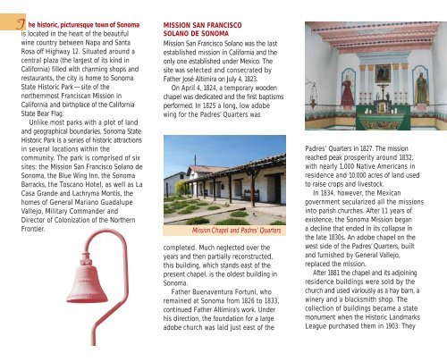
performed. In 1825 a long, low adobe<br />
wing for the Padres’ Quarters was<br />
Mission Chapel and Padres’ Quarters<br />
completed. Much neglected over the<br />
years and then partially reconstructed,<br />
this building, which stands east of the<br />
present chapel, is the oldest building in<br />
<strong>Sonoma</strong>.<br />
Father Buenaventura Fortuni, who<br />
remained at <strong>Sonoma</strong> from 1826 to 1833,<br />
continued Father Altimira’s work. Under<br />
his direction, the foundation for a large<br />
adobe church was laid just east of the<br />
Padres’ Quarters in 1827. The mission<br />
reached peak prosperity around 1832,<br />
with nearly 1,000 Native Americans in<br />
residence and 10,000 acres of land used<br />
to raise crops and livestock.<br />
In 1834, however, the Mexican<br />
government secularized all the missions<br />
into parish churches. After 11 years of<br />
existence, the <strong>Sonoma</strong> Mission began<br />
a decline that ended in its collapse in<br />
the late 1830s. An adobe chapel on the<br />
west side of the Padres’ Quarters, built<br />
and furnished by General Vallejo,<br />
replaced the mission.<br />
After 1881 the chapel and its adjoining<br />
residence buildings were sold by the<br />
church and used variously as a hay barn, a<br />
winery and a blacksmith shop. The<br />
collection of buildings became a state<br />
monument when the <strong>Historic</strong> Landmarks<br />
League purchased them in 1903. They