National Meteorological Library and Archive Fact sheet 15 - Met Office
National Meteorological Library and Archive Fact sheet 15 - Met Office
National Meteorological Library and Archive Fact sheet 15 - Met Office

You also want an ePaper? Increase the reach of your titles
YUMPU automatically turns print PDFs into web optimized ePapers that Google loves.
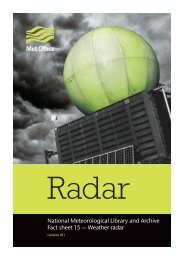
Radar<br />
<strong>National</strong> <strong><strong>Met</strong>eorological</strong> <strong>Library</strong> <strong>and</strong> <strong>Archive</strong><br />
<strong>Fact</strong> <strong>sheet</strong> <strong>15</strong> — Weather radar<br />
(version 01)
The <strong>National</strong> <strong><strong>Met</strong>eorological</strong> <strong>Library</strong> <strong>and</strong> <strong>Archive</strong><br />
Many people have an interest in the weather <strong>and</strong> the processes that cause it, which is why the <strong>National</strong><br />
<strong><strong>Met</strong>eorological</strong> <strong>Library</strong> <strong>and</strong> <strong>Archive</strong> are open to everyone.<br />
Holding one of the most comprehensive collections on meteorology anywhere in the world, the<br />
<strong>Library</strong> <strong>and</strong> <strong>Archive</strong> are vital for the maintenance of the public memory of the weather, the storage of<br />
meteorological records <strong>and</strong> as an aid of learning.<br />
The <strong>Library</strong> <strong>and</strong> <strong>Archive</strong> collections include:<br />
• around 300,000 books, charts, atlases, journals, articles, microfiche <strong>and</strong> scientific papers on<br />
meteorology <strong>and</strong> climatology, for a variety of knowledge levels<br />
• audio-visual material including digitised images, slides, photographs, videos <strong>and</strong> DVDs<br />
• daily weather reports for the United Kingdom from 1861 to the present, <strong>and</strong> from around the world<br />
• marine weather log books<br />
• a number of the earliest weather diaries dating back to the late 18th century<br />
• artefacts, records <strong>and</strong> charts of historical interest; for example, a chart detailing the weather conditions<br />
for the D-Day L<strong>and</strong>ings, the weather records of Scott’s Antarctic expedition from 1911<br />
• rare books, including a 16th century edition of Aristotle’s <strong>Met</strong>eorologica, held on behalf of the<br />
Royal <strong><strong>Met</strong>eorological</strong> Society<br />
• a display of meteorological equipment <strong>and</strong> artefacts<br />
For more information about the <strong>Library</strong> <strong>and</strong> <strong>Archive</strong> please see our website at:<br />
www.metoffice.gov.uk/corporate/library
The word RADAR is an acronym, for RAdio Detection And Ranging.<br />
Radar – a brief history<br />
Although some primitive work on radio location had been carried out in the United Kingdom as early as<br />
1904, it wasn’t until the mid 1930s before any serious development work on radar was instigated.<br />
In 1935, Robert Watson-Watt, a meteorologist by training <strong>and</strong> with an aim of applying his knowledge<br />
of radio to locate thunderstorms so as to provide warnings to airmen, patented the first practical radar<br />
system, not to look at rainfall echoes but, with war with Germany becoming a real possibility, to look for<br />
enemy aircraft, if <strong>and</strong> when war broke out.<br />
Figure 1. Robert Watson-Watt.<br />
When the first weather echoes were detected <strong>and</strong> recognised is not certain, but during the war weather<br />
echoes were regarded as a nuisance rather than of intrinsic value. Nevertheless, before the end of the<br />
war the <strong><strong>Met</strong>eorological</strong> <strong>Office</strong> had established a radar research station at East Hill, some 30 miles north of<br />
London. For a time after the war, the <strong><strong>Met</strong>eorological</strong> <strong>Office</strong> radar station at East Hill concentrated on the<br />
examination of turbulence, no doubt at the instigation of Sir Graham Sutton, who was the first Director<br />
of Telecommunication Research Establishment <strong>and</strong> then of the <strong><strong>Met</strong>eorological</strong> <strong>Office</strong>, <strong>and</strong> whose major<br />
interest was in turbulence.<br />
In the early 1950s the <strong><strong>Met</strong>eorological</strong> <strong>Office</strong> began investigations examining the accuracy of precipitation<br />
forecasts based on the movement of radar echoes. Although it was found that the radar display could be<br />
of help to the forecaster, <strong>and</strong> subsequently in 1955 a radar was installed in London for the forecast office,<br />
the results were not sufficiently encouraging for much progress in this field.<br />
In recent years, advances in data processing, communications <strong>and</strong> display technology have enabled the<br />
full potential of meteorological radar to be exploited. Various investigations have shown that the accuracy<br />
of rainfall estimates over large areas obtained from radar data, adjusted by a small number of check<br />
gauges, is better than that obtained from a dense network of rain gauges.
How does radar work?<br />
Radar is an echo-sounding system, which uses the same aerial for transmitting a signal <strong>and</strong> receiving the<br />
returned echo.<br />
Figure 2. How radar works.<br />
Short pulses of electro-magnetic waves, which travel at the speed of light (approx. 186000 miles per<br />
second), are transmitted in a narrow beam for a very short time (typically 2 microseconds).<br />
When the beam hits a suitable target, some of the energy is reflected back to the radar, which ‘listens’ out<br />
for it for a much longer period (3300 microseconds in the case of <strong>Met</strong> <strong>Office</strong> radars) before transmitting<br />
a new pulse. The distance of the target from the transmitter can be worked out from the time taken by a<br />
pulse to travel there <strong>and</strong> back.<br />
The range <strong>and</strong> power of a radar<br />
Since radars cannot send <strong>and</strong> receive at the same time, the transmitted pulse must be very short (or<br />
echoes from close range will be lost), <strong>and</strong> the listening time must be as long as possible, for detecting<br />
distant echoes. Increasingly the transmitted power is subject to engineering constraints <strong>and</strong> cost.<br />
A longer transmission pulse would give more power <strong>and</strong> better long-range performance, but would<br />
reduce the close-range capability.<br />
The returning echo is very much weaker than the transmitted pulse, <strong>and</strong> depends on several factors.<br />
There is attenuation, or absorption of energy, by particles of dust or cloud droplets in the atmosphere.<br />
There is also an inverse square relationship with range (i.e. doubling the range cuts the return power to<br />
one quarter) due to the increasing spread of the radar beam. The beam width of many modern radars is<br />
approximately 1° <strong>and</strong>, as the target distance increases, only an increasingly small part of the transmitted<br />
beam is reflected back to the radar.
Location of radars across the British Isles<br />
Site Name <strong>National</strong> Grid Reference Latitude Longitude Location<br />
Eastings<br />
Northings<br />
Clee Hill 359485 277940 52°23’53”N 002°35’49”W Titterstone Clee, near Ludlow,<br />
Shropshire<br />
Hameldon Hill 381060 428740 53°45’17”N 002°17’19”W Dunnockshaw, near<br />
Burnley, Lancashire<br />
Chenies 501642 199959 51°41’21”N 000°31’50”W Flauden, near Amersham,<br />
Hertfordshire<br />
Castor Bay 119112 520302 54°30’00”N 006°20’24”W Near Lurgan, Belfast,<br />
Northern Irel<strong>and</strong><br />
Predannack 169185 016440 50°00’12”N 005°13’21”W Near Ruan Major, The Lizard,<br />
Cornwall<br />
Ingham 496045 382975 53°20’06”N 000°33’33”W Ingham, near Lincoln,<br />
Lincolnshire<br />
Crug-y-Gorllwyn 232190 234085 51°58’47”N 004°26’41”W Near Capel Iwan,<br />
Carmarthen, Carmarthenshire<br />
Hill of Dudwick 397925 837835 57°25’51”N 002°02’10”W Near Ellon, Aberdeenshire<br />
Druim a’Starraig <strong>15</strong>4395 932345 58°12’40”N 006°10’59”W Near Stornaway, Isle of Lewis<br />
Cobbacombe<br />
Cross<br />
298080 119230 50°57’48”N 003°27’10”W Huntsham, near Tiverton,<br />
Devon<br />
Thurnham 581670 <strong>15</strong>8290 51°17’41”N 000°36’<strong>15</strong>”E Near Maidstone, Kent<br />
Dean Hill 424335 125730 51°01’50”N 001°39’16”W Near West Dean, Salisbury,<br />
Wiltshire<br />
Holehead 261790 682835 56°01’06”N 004°13’08”W Holehead, near Fintry, Stirling<br />
Munduff Hill 318820 703225 56°12’53”N 003°18’38”W Near Kinnesswood,<br />
Glenrothes, Fife<br />
High Moorsley 433873 545572 54°48’20”N 001°28’32”W Near Durham<br />
Jersey - - 49°12’34”N 002°11’56”W La Moye, Jersey<br />
Channel Isl<strong>and</strong>s<br />
Dublin 117207 400906 53°25’44”N 006°<strong>15</strong>’31”W Dublin Airport, Irel<strong>and</strong><br />
Shannon - - 52°42’01”N 008°55’24”W Shannon Airport, County<br />
Clare, Irel<strong>and</strong><br />
Table 1. Current radar locations.<br />
Proposed new rainfall radar sites in the British Isles<br />
Site Name <strong>National</strong> Grid Reference Latitude Longitude Location<br />
Eastings<br />
Northings<br />
Old Buckenham 608500 293500 52°29’58”N 001°04’13”E Near Carleton Rode,<br />
Attleborough, Norfolk<br />
Table 2. Proposed additional radar locations.
Current British Isles weather radar network<br />
Druim a’Starraig<br />
Hill of Dudwick<br />
Holehead<br />
Munduff Hill<br />
Castor Bay<br />
High Moorsley<br />
Dublin<br />
Hameldon Hill<br />
Ingham<br />
Shannon<br />
Clee Hill<br />
Old Buckenham<br />
(Proposed)<br />
Crug-y-Gorllwyn<br />
Cobbacombe Cross<br />
Dean Hill<br />
Chenies<br />
Thurnham<br />
Predannack<br />
• Operational<br />
Note: an additional radar is located at La Moye, Jersey (49°12’34”N, 002°11’56”W)<br />
1 km resolution 2 km resolution<br />
5 km resolution<br />
Figure 3. Current rainfall radar coverage across the British Isles.
Radar transmitter/receiver<br />
On-site computer<br />
St<strong>and</strong>-by generator<br />
Figure 4. View of the internal workings of a weather radar.<br />
Figure 5. Weather radar, Figure 6. Weather radar Figure 7. Weather radar,<br />
Stornoway, Isle of Lewis. Chenies, Hertfordshire. Dean Hill, Wiltshire.
At each radar location an on-site computer carries out aerial elevation control <strong>and</strong> digital signal processing.<br />
The raw data is then sent to the Radarnet IV Central Processing at Exeter where the following processing<br />
is carried out:<br />
• Correction for attenuation by intervening rain<br />
• Correction to range attenuation<br />
• Elimination of ground clutter<br />
• Conversion of radar reflectivity to rainfall rate<br />
• Conversion from polar cells to <strong>National</strong> Grid Cartesian cells<br />
The radar network is then linked to a central computer at the <strong>Met</strong> <strong>Office</strong> Headquarters in Exeter. Each<br />
radar is owned by a consortium of agencies, such as the Environment Agency, with the <strong>Met</strong> <strong>Office</strong><br />
providing the technical <strong>and</strong> operational support.<br />
Each radar completes a series of scans about a vertical axis between four <strong>and</strong> eight low-elevation angles<br />
every 5 minutes (typically between 0.5 <strong>and</strong> 4.0 degrees, depending on the height of surrounding hills).<br />
Each scan gives good, quantitative data (1 <strong>and</strong> 2 km resolutions) out to a range of about 75 km <strong>and</strong> useful<br />
qualitative data (5 km resolution) to 255 km.<br />
• 5 km resolution data provides a good overall picture of the extent of precipitation at a national/regional<br />
scale.<br />
• 2 km data coverage extends over 85% of Engl<strong>and</strong> <strong>and</strong> Wales <strong>and</strong> shows more detailed distribution of<br />
precipitation intensities. It is suitable for more dem<strong>and</strong>ing rainfall monitoring <strong>and</strong> hydrological<br />
applications.<br />
• 1 km resolution provides the most detailed information, down to the scale of individual convective<br />
clouds. It is designed to assist real-time monitoring of small urban catchments <strong>and</strong> sewer systems.<br />
The radar image displayed gives the rainfall rate in nine colour intensity b<strong>and</strong>s.<br />
0 – 0.25 mm per hour<br />
0.25 – 0.5 mm per hour<br />
0.5 – 1.0 mm per hour<br />
1 – 2 mm per hour<br />
2 – 4 mm per hour<br />
4 – 8 mm per hour<br />
8 – 16 mm per hour<br />
16 – 32 mm per hour<br />
>32 mm per hour<br />
Table 3. Rainfall intensity colour b<strong>and</strong>s.<br />
This data provides valuable information for the immediate emergency response <strong>and</strong> the longer term<br />
planning of future risk management <strong>and</strong> mitigation.
Below is a set of radar images from the Chenies Rainfall Radar, all from the same time <strong>and</strong> for the same<br />
area, but at 5, 2 <strong>and</strong> 1 km horizontal resolutions. They show instantaneous rainfall rates, but with<br />
increasing horizontal resolution, <strong>and</strong> this shows some intense rainfall cells between Dunstable <strong>and</strong><br />
Stevenage that only become identifiable in the higher resolution image.<br />
Figure 8.<br />
5 km resolution.<br />
Figure 9.<br />
2 km resolution.<br />
Figure 10.<br />
1 km resolution.
Weather radar is very useful for forecasters in areas where there is little observable data. One recent<br />
example was during the floods at Boscastle in Cornwall on 16 August 2004. With no real-time<br />
observations from that area, the nearest observing site is at St. Mawgan, approximately 20 miles away.<br />
Weather radar provided vital information about the rainfall intensities in that local area <strong>and</strong> allowed the<br />
<strong>Met</strong> <strong>Office</strong> to provided valuable information to the emergency services.<br />
0 – 0.25<br />
0.25 – 0.5<br />
0.5 – 1.0<br />
1 – 2<br />
2 – 4<br />
4 – 8<br />
8 – 16<br />
16 – 32<br />
32 – 64<br />
64 – 96<br />
96 – 128<br />
>128<br />
Figure 11. Radar rainfall accumulations from the Cobbacombe Cross radar<br />
(2 km resolution 1100 – 1800 UTC) during the Boscastle floods of 16 August 2004.<br />
Raingauge name<br />
<strong>National</strong><br />
grid reference<br />
24-hour<br />
rainfall total (mm)<br />
Event total (mm)<br />
Otterham* SX 169 916 200.4 –<br />
Trevalec, Lesnewth SX 134 900 184.9 181.0 (11:30 to 16:30 GMT)<br />
Trevalec, Lesnewth SX 134 900 <strong>15</strong>5.8 <strong>15</strong>2.8 (12:<strong>15</strong> to 16:19 GMT)<br />
Creddacott SX 231 956 123.0 –<br />
Slaughterbridge<br />
TBR<br />
SX 109 857 76.5 –<br />
Bude SX 208 063 46.7 –<br />
Canworthy Water<br />
TBR<br />
Lower Tregellist<br />
(St Kew)<br />
SX 228 916 <strong>15</strong>.0 –<br />
SX 006 775 5.9 –<br />
Lower Moor SX 128 833 2.0 –<br />
*The 24 hour value from Otterham would give a return period in excess of 200 years (using the Flood<br />
Estimation H<strong>and</strong>book method).<br />
Table 4. 24-hour rainfall amounts during the Boscastle floods of 16 August 2004.<br />
By cycling the display forwards <strong>and</strong>/or backwards, both the motion <strong>and</strong> growth/decay of rainfall events<br />
can be observed.
Doppler radar<br />
Depending on the equipment installed it is possible to obtain direction <strong>and</strong> speed information on the<br />
droplets observed. Using this data it is then possible to calculate wind speed <strong>and</strong> elevation data within the<br />
rain cloud, out to a range of 100 km from the radar. This data is then used, amongst others, by the <strong>Met</strong><br />
<strong>Office</strong>’s Numerical Weather Prediction team with the ultimate aim of improving the numerical model that<br />
is used to forecast the weather; this in turn increases the accuracy of the forecasts that are issued.<br />
Doppler radar used by the <strong>Met</strong> <strong>Office</strong> is still in its experimental stage but the sites currently equipped<br />
with Doppler radar are:<br />
• Druim a’Starraig<br />
• Hill of Dudwick<br />
• Clee Hill<br />
• Holehead<br />
• Thurnham<br />
• Cobbacombe Cross<br />
• Dean Hill<br />
The way Doppler radar works is that two pulses of electromagnetic radiation are transmitted. The first<br />
pulse is sent from the radar <strong>and</strong> the returning echoes are received, then almost immediately, a second<br />
pulse is sent from the radar <strong>and</strong> again the returning echo is received. The computer then analyses these<br />
two returned echoes <strong>and</strong> the movement of the droplets of water is calculated. This movement is only<br />
very slight but it is enough to calculate the wind speed within the cloud <strong>and</strong> the direction of the water<br />
droplets.<br />
Cobbacombe<br />
8<br />
6<br />
Height km<br />
4<br />
2<br />
0<br />
00 01 02 03 04 05 06 07 08 09 10 11 12 13 14 <strong>15</strong> 16 17 18 19 20 21 22 23<br />
02<br />
November<br />
2009<br />
Time UTC<br />
Figure 12. Wind profile generated by the Cobbacombe Cross Doppler radar.
Interpreting radar imagery<br />
The radars do not receive echoes from tiny cloud particles, but only from the precipitation-sized droplets.<br />
Drizzle is generally too small to be reliably observed, unless close to the radar, but rain, snow <strong>and</strong> hail are<br />
all observed without difficulty.<br />
It is important to interpret the radar imagery in terms of the beam’s elevation <strong>and</strong> ‘width’ <strong>and</strong> the earth’s<br />
curvature. The latter, for example, means that echoes come from an increasingly higher level the further<br />
away precipitation is from the radar. Thus at a range of 100 km, the radar beam is being reflected from the<br />
raindrops in a cloud at a height of 1.5 km, but beneath that level rain may be falling from the cloud which<br />
the radar misses. For this <strong>and</strong> other reasons (listed below), the radar rainfall display may not fully represent<br />
the rainfall observed at the ground.<br />
Non-meteorological echoes<br />
• Permanent echoes (occultation)<br />
These are caused by hills or surface obstacles blocking the radar beam, <strong>and</strong> are often referred to as clutter.<br />
Clutter is rarely seen on radar imagery as it can be mapped on a cloudless day, <strong>and</strong> then taken out or<br />
subsequent pictures by the on-site computer.<br />
Figure 13. Non-meteorological echoes – permanent echoes caused by buildings etc.<br />
Figure 14. Clee hill radar display showing a break<br />
in the beam (occulation) caused by the Cambrian<br />
Mountain in Wales.
Occultation is caused by the radar beam being obstructed by a hill or building. A network of overlapping<br />
radars helps to minimise this problem.<br />
• Spurious echoes<br />
These may be caused by ships, aircraft, sea waves, chaff in use on military exercises, technical problems or<br />
interference from other radars. The pattern formed by spurious echoes are short-lived, <strong>and</strong> can usually be<br />
identified as they look very different from genuine precipitation echoes.<br />
Figure <strong>15</strong>. Non-meteorological echoes – spurious echoes caused by chaff used in military exercises.<br />
<strong><strong>Met</strong>eorological</strong> causes of errors<br />
• Radar beam above the precipitation at long ranges<br />
Figure 16. <strong><strong>Met</strong>eorological</strong> causes of errors – radar beam above the precipitation at long distances.
Even with a beam elevation of only 1°, an individual radar may not detect low-level rain clouds at long <br />
distances. A network of overlapping radars helps to minimise this problem.<br />
• Evaporation of rainfall at lower levels beneath the beam<br />
Figure 17. <strong><strong>Met</strong>eorological</strong> causes of errors – evaporation of rainfall at lower levels beneath the beam.<br />
Precipitation detected by the radar at high levels may evaporate if it falls through drier air nearer the<br />
ground. The radar rainfall display will then give an over-estimate of the actual rainfall.<br />
• Orographic enhancement of rainfall at low levels.<br />
The rather light precipitation which is generated in layers of medium-level frontal cloud can increase in<br />
intensity by sweeping up other small droplets as it falls through moist, cloudy layers at low levels.<br />
This seeder-feeder mechanism is very common over hills, resulting in very high rainfall rates <strong>and</strong><br />
Figure 18. <strong><strong>Met</strong>eorological</strong> causes of errors – orographic enhancement of rainfall at low levels.
accumulations. Even with a network of radars, the screening effect of hills can make the detection of this<br />
orographic enhancement difficult, resulting in an under-estimate of the actual rainfall.<br />
• Bright b<strong>and</strong><br />
Radar echoes from both raindrops <strong>and</strong> snowflakes are calibrated to give correct intensities on the rainfall<br />
display. But at the level where the temperature is near 0 °C, melting snowflakes with large, wet, reflective<br />
surfaces give strong echoes. These produce a false b<strong>and</strong> of heavier rain, or bright b<strong>and</strong>, on the radar<br />
picture.<br />
Figure 19. <strong><strong>Met</strong>eorological</strong> causes of errors – bright b<strong>and</strong>.<br />
• Drop sizes of precipitation within a cloud<br />
Every cloud has a different composition of droplets; in particular, frontal rainfall clouds differ from<br />
convective shower clouds. In deriving rainfall rates from radar echo intensities, average values for cloud<br />
compositions are used. Radars under-estimate the rain from clouds composed of smaller-than-average<br />
drops (e.g. drizzle), <strong>and</strong> over estimate the rain falling from clouds with very large drops (e.g. showers).<br />
Figure 20. <strong><strong>Met</strong>eorological</strong> causes of errors – drop size of precipitation.
However, averaging the rain over 5 km squares on the radar rainfall display reduces the peak intensities in<br />
convective cells.<br />
• Anomalous propagation (anaprop)<br />
Radar beams are like light beams, in that they travel in straight lines through a uniform medium but will<br />
be bent (refracted) when passing through air of varying density. When a low-level temperature inversion<br />
exists (see fact <strong>sheet</strong> number 13 – Upper Air Observations <strong>and</strong> The Tephigram), the radar beam is bent<br />
downwards <strong>and</strong> strong echoes are returned from the ground, in a manner akin to the formation of<br />
mirages. This usually occurs in anticyclones, where rain is unlikely <strong>and</strong> so anaprop is normally recognised<br />
without difficulty.<br />
Figure 21. <strong><strong>Met</strong>eorological</strong> causes of errors – anomalous propagation (anaprop).<br />
Advantages <strong>and</strong> disadvantages of weather radar<br />
Advantages:<br />
• Detailed, instantaneous <strong>and</strong> integrated rainfall rates<br />
• Areal rainfall estimates over a wide area<br />
• Information in near-real time<br />
• Information in remote l<strong>and</strong> areas <strong>and</strong> over adjacent seas<br />
• Location of frontal <strong>and</strong> convective (shower) precipitation<br />
• Monitoring movement <strong>and</strong> development of precipitation areas<br />
• Short-range forecasts made by extrapolation<br />
• Data can be assimilated into numerical weather prediction models<br />
Disadvantages:<br />
• Display does not show rainfall actually at the surface<br />
• Display also shows non-meteorological echoes<br />
• Estimates liable to error due to technical <strong>and</strong> meteorological related causes
Radar imagery used in real-life weather forecasting<br />
Radar imagery is just one of the tools that a forecaster has at their disposal when analysing weather<br />
patterns in order to issue a forecast. For example, on the 2 December 2005 a vigorous depression<br />
approached the far southwest of Engl<strong>and</strong>. Using satellite imagery, it was possible to follow the cloud<br />
patterns associated with this depression but only when the rainfall radar was used was it possible to see<br />
exactly where the heaviest rain was falling <strong>and</strong> issue warnings as appropriate.<br />
metoffice.gov.uk<br />
©Crown copyright<br />
Figure 22. North Atlantic surface synoptic chart for 1200Z on 2 December 2005.<br />
Summary of United Kingdom weather for 2 December 2005<br />
Much of the UK had a cloudy, mild <strong>and</strong> wet night with outbreaks of rain. The rain was heavy in places <strong>and</strong><br />
there were gales along the exposed coasts of south Wales, the English Channel <strong>and</strong> East Anglia. The rain<br />
turned showery over southwest Engl<strong>and</strong>. It remained dry across central <strong>and</strong> northwest Scotl<strong>and</strong> with air<br />
frost in Highl<strong>and</strong>.<br />
Areas of rain tended to fragment as they continued to move north or northwest across the UK during the<br />
morning. However, the rain became persistent across Northern Irel<strong>and</strong> <strong>and</strong> eastern Scotl<strong>and</strong> during the<br />
afternoon. At the same time, heavy showery rain developed across southwest Engl<strong>and</strong> <strong>and</strong> south Wales.<br />
Frequent heavy showers then developed over much of Engl<strong>and</strong> <strong>and</strong> Wales, with local hail <strong>and</strong> thunder<br />
across south <strong>and</strong> southeast Engl<strong>and</strong>. It was a windy day with gales in places. Maximum gusts included 69<br />
knots at the Isle of Portl<strong>and</strong> (Dorset), 67 knots at Alderney (Channel Isl<strong>and</strong>s), 63 knots at Brixham (Devon)<br />
<strong>and</strong> 62 knots at Guernsey airport (Channel Isl<strong>and</strong>s).<br />
The afternoon temperatures were in the normal or mild categories.
The midday satellite image shows a deep <strong>and</strong><br />
well developed area of low pressure centred in<br />
the western English Channel between Brest <strong>and</strong><br />
Plymouth. The image shows clearly the cloud<br />
structure swirling around the centre with b<strong>and</strong>s<br />
of rain <strong>and</strong> also some quite heavy <strong>and</strong> blustery<br />
showers. The main frontal zone can be seen from<br />
south of Irel<strong>and</strong> extending across Scotl<strong>and</strong> to the<br />
North Sea then across the continent to the western<br />
Mediterranean.<br />
Figure 23. Visible satellite image for 1200Z on<br />
2 December 2005.<br />
The 1255z radar image shows the swirl of<br />
precipitation associated with a deep depression<br />
centred in the western English Channel between<br />
Brest <strong>and</strong> Plymouth. This image shows clearly the<br />
frontal rain across Scotl<strong>and</strong> <strong>and</strong> Irel<strong>and</strong> as well as<br />
the showery activity swirling around the centre of<br />
the depression.<br />
Figure 24. United Kingdom 5 km radar imagery<br />
composite for 1255Z on 2 December 2005.<br />
The 1255z Predannack radar image shows the<br />
swirl of precipitation associated with a deep <strong>and</strong><br />
a well developed area of low pressure centred in<br />
the western English Channel between Brest <strong>and</strong><br />
Plymouth.<br />
Figure 25. Predannack 5 km radar imagery for<br />
1255Z on 2 December 2005.
The midday surface chart of the British Isles shows a deep area of low pressure in the western English<br />
Channel with its associated occluded frontal system wrapped around it. Also depicted on this chart is a<br />
warm front across the western part of Scotl<strong>and</strong> <strong>and</strong> into Northern Irel<strong>and</strong> <strong>and</strong> a trailing cold front lying<br />
from Northern Irel<strong>and</strong>, through Dumfries <strong>and</strong> Galloway, Cumbria, across the Pennines <strong>and</strong> down through<br />
East Yorkshire <strong>and</strong> away into the North Sea <strong>and</strong> onwards into the near continent. Following on behind this<br />
cold front is a trough running from North Wales, across the Midl<strong>and</strong>s <strong>and</strong> Southeast Engl<strong>and</strong> then away<br />
into Northern France.<br />
Figure 26. <strong>Met</strong> <strong>Office</strong>’s Operations Centre analysis chart for 1200Z on 2 December 2005.
This fact <strong>sheet</strong> has been produced in conjunction with the <strong>Met</strong> <strong>Office</strong>’s Observation Networks remote<br />
sensing section.<br />
For more information about Remote Sensing, please contact the <strong>Met</strong> <strong>Office</strong> Customer Centre on:<br />
Tel: 0870 900 0100<br />
Fax: 0870 900 5050<br />
Email: enquiries@metoffice.gov.uk<br />
If you are outside the UK:<br />
Tel: +44 (0)1392 885680 <br />
Fax: +44 (0)1392 885681<br />
All of the images used in this fact <strong>sheet</strong> along with many others covering all aspects of meteorology can be <br />
obtained from the <strong>National</strong> <strong><strong>Met</strong>eorological</strong> <strong>Library</strong>.<br />
For more information about what images are available, please contact the <strong>Library</strong> Information <strong>Office</strong>r at:<br />
Tel: 01392 884845 <br />
Email: metlib@metoffice.gov.uk
Other Titles in this series still available are:<br />
• Number 1 Clouds<br />
• Number 2 Thunderstorms<br />
• Number 3 Water in the Atmosphere<br />
• Number 4 Climate of the British Isles<br />
• Number 5 White Christmases<br />
• Number 6 The Beaufort Scale<br />
• Number 7 Climate of Southwest Engl<strong>and</strong><br />
• Number 8 The Shipping Forecast<br />
• Number 9 Weather Extremes<br />
• Number 10 Air Masses <strong>and</strong> Weather Fronts<br />
• Number 11 Interpreting Weather Charts<br />
• Number 12 <strong>National</strong> <strong><strong>Met</strong>eorological</strong> <strong>Archive</strong><br />
• Number 13 Upper Air Observation <strong>and</strong> The Tephigram<br />
• Number 14 Microclimates<br />
• Number 16 World climates<br />
• Number 17 Weather observations
Our unique collection of weather images is now available via the <strong>National</strong> <strong><strong>Met</strong>eorological</strong> <strong>Library</strong><br />
<strong>and</strong> <strong>Archive</strong>’s online catalogue.<br />
The collection illustrates all aspects of meteorology, from clouds <strong>and</strong> weather phenomena, to<br />
instruments <strong>and</strong> the work of the <strong>Met</strong> <strong>Office</strong>. Our online catalogue can be found at:<br />
www.metoffice.gov.uk/corporate/library/catalogue.html<br />
All of the fact <strong>sheet</strong>s in this series are available to download from the <strong>Met</strong> <strong>Office</strong>’s website.<br />
The full list can be found at:<br />
www.metoffice.gov.uk/corporate/library/fact<strong>sheet</strong>s.html<br />
<strong>Met</strong> <strong>Office</strong> Tel: 0870 900 0100 Produced by the <strong>Met</strong> <strong>Office</strong>.<br />
FitzRoy Road, Exeter Fax: 0870 900 5050 © Crown copyright 2009 09/0228<br />
Devon, EX1 3PB enquiries@metoffice.gov.uk <strong>Met</strong> <strong>Office</strong> <strong>and</strong> the <strong>Met</strong> <strong>Office</strong> logo<br />
United Kingdom www.metoffice.gov.uk are registered trademarks