

Lake Erie North Shore Watershed Plan - Niagara Peninsula ...
Lake Erie North Shore Watershed Plan - Niagara Peninsula ...
Lake Erie North Shore Watershed Plan - Niagara Peninsula ...

Create successful ePaper yourself
Turn your PDF publications into a flip-book with our unique Google optimized e-Paper software.
LAKE ERIE NORTH SHORE WATERSHED PLAN<br />
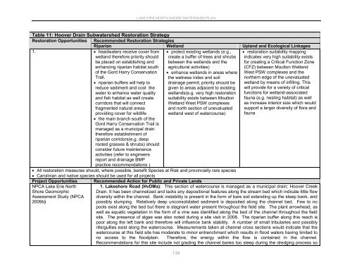
Table 11: Hoover Drain Subwatershed Restoration Strategy<br />
Restoration Opportunities Recommended Restoration Strategies<br />
Riparian Wetland Upland and Ecological Linkages<br />
1. headwaters receive cover from<br />
wetland therefore priority should<br />
be placed on establishing and<br />
enhancing riparian habitat south<br />
of the Gord Harry Conservation<br />
Trail.<br />
riparian buffers will help to<br />
reduce sediment and cool the<br />
water to enhance water quality<br />
and fish habitat as well create<br />
corridors that will connect<br />
fragmented natural areas<br />
providing cover for wildlife<br />
protect existing wetlands (e.g.,<br />
create a buffer of trees and shrubs<br />
between the wetlands and the<br />
agricultural activities)<br />
enhance wetlands in areas where<br />
the wetness index and soil<br />
drainage permit; priority should be<br />
given to areas adjacent to existing<br />
wetlands(e.g. very high restoration<br />
suitability exists between Moulton<br />
Wetland West PSW complexes<br />
and north section of unevaluated<br />
wetland west of watercourse)<br />
restoration suitability mapping<br />
indicates very high suitability exists<br />
for creating a Critical Function Zone<br />
(CFZ) between Moulton Wetland<br />
West PSW complexes and the<br />
northern edge of the unevaluated<br />
wetland by means of infilling. This<br />
will provide for a variety of critical<br />
functions for wetland-associated<br />
fauna (e.g. nesting habitat) as well<br />
as increase interior size which would<br />
support a larger diversity of flora and<br />
fauna<br />
the main branch south of the<br />
Gord Harry Conservation Trail is<br />
managed as a municipal drain<br />
therefore establishment of<br />
riparian corridors(e.g. deep<br />
rooted grasses & shrubs) should<br />
consider future maintenance<br />
activities (refer to engineers<br />
report and drainage BMP<br />
practice recommendations )<br />
All restoration measures should, where possible, benefit Species at Risk and provincially rare species<br />
Carolinian and native species should be used for all projects<br />
Project Opportunities<br />
NPCA <strong>Lake</strong> <strong>Erie</strong> <strong>North</strong><br />
<strong>Shore</strong> Geomorphic<br />
Assessment Study (NPCA<br />
2009b)<br />
Recommended Action for Public and Private Lands<br />
1. <strong>Lake</strong>shore Road (HvDMa): This section of watercourse is managed as a municipal drain; Hoover Creek<br />
Drain. It has been channelized and lacks any depositional features along the stream bed which indicate little flow<br />
diversity within the channel. Bank instability is present in the form of bare soil extending up the steep bank, and<br />
possibly slumping. Relatively deep unconsolidated sediment is deposited along the channel bed. Few to no<br />
pools exist along the bed but there is stagnant water present throughout the field site. The plant arrowhead, as<br />
well as aquatic vegetation in the form of a vine was identified along the bed of the channel throughout the field<br />
site. The presence of algae was also noted during a site visit in 2008. The riparian buffer along this reach is<br />
poor along the left bank and therefore will influence bank stability. A number of small tributaries and possibly<br />
rills/gullies exist along the watercourse. Measurements taken at channel cross sections would indicate that the<br />
watercourse at this field site has moderate to minor entrenchment which results in flood waters having limited to<br />
no access to the floodplain. Therefore, the energy within the flow is contained in the channel.<br />
Recommendations for this site include not grading the channel banks too steep during the dredging process so<br />
139


