

Lake Erie North Shore Watershed Plan - Niagara Peninsula ...
Lake Erie North Shore Watershed Plan - Niagara Peninsula ...
Lake Erie North Shore Watershed Plan - Niagara Peninsula ...

Create successful ePaper yourself
Turn your PDF publications into a flip-book with our unique Google optimized e-Paper software.
LAKE ERIE NORTH SHORE WATERSHED PLAN<br />
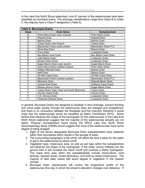
In the <strong>Lake</strong> <strong>Erie</strong> <strong>North</strong> <strong>Shore</strong> watershed, over 61 percent of the watercourses have been<br />
classified as municipal drains. The drainage classifications range from Class B to Class<br />
F; the majority have a Class F designation (Table 6).<br />
Table 6: Municipal Drains<br />
Class Drain Name Subwatershed<br />
B Point Abino Drain-main channel Point Abino Drain<br />
B Wignell Drain Wignell Drain<br />
C Bearss Drain Bearss Drain<br />
C Casey Drain-main branch Casey Drain<br />
C Beaverdam Drain-south portion Beaverdam Drain P.C<br />
C Silver Bay Drain Bearss Drain<br />
D Furry Drain Lowbanks Drain<br />
E Bay Beach Area Drain Bay Beach Area Drain<br />
E Little Marsh Drain Lowbanks Drain<br />
E Boulton Ditch Drain Lowbanks Drain<br />
E Eagle Marsh Drain-main branch Eagle Marsh Drain<br />
F Point Abino Drain-northern branch Point Abino Drain<br />
F William-Michael Drain Bearss Drain<br />
F Neff Drain Bearss Drain<br />
F Oil Mill Creek Drain Oil Mill Creek Drain<br />
F Beaverdam Drain-northern portion Beaverdam Drain P.C<br />
F Michener Drain Wignell Marsh Drain<br />
F Central Park Drain Welland Canal South<br />
F Bessey Branch Drain Eagle Marsh Drain<br />
F Casey Drain: East, West and <strong>North</strong> Branches Casey Drain<br />
F Hoover Creek Drain Hoover Drain<br />
F H.E. Dickout Drain Lowbanks Drain<br />
F Chalmers Dickout Drain Lowbanks Drain<br />
In general, Municipal Drains are designed to facilitate in land drainage, prevent flooding<br />
and move water quickly through the watercourse (they are dredged and straightened,<br />
and there is no connection between the floodplain and the channel), therefore it would<br />
imply that the watercourses would be classified as flashy (VanRiezen 2010). Some<br />
factors that influence the shape of the hydrograph for the watercourses in the <strong>Lake</strong> <strong>Erie</strong><br />
<strong>North</strong> <strong>Shore</strong> watershed suggest that the majority of the watercourses actually are not<br />
flashy. Physical characteristics found during the NPCA <strong>Lake</strong> <strong>Erie</strong> <strong>North</strong> <strong>Shore</strong><br />
Geomorphology Study (2009b) would suggest that most of the watercourses have some<br />
degree of being sluggish.<br />
1. Eight of the eleven designated Municipal Drain subwatersheds have wetlands<br />
within their boundaries which results in the storage of water.<br />
2. The surrounding topography is flat which will affect the time it takes for the water<br />
to get to the watercourse by direct runoff.<br />
3. Vegetation type, impervious area, as well as soil type within the subwatershed<br />
will influence the shape of the hydrograph. If the water cannot infiltrate into the<br />
ground then it will increase the direct runoff and produce a flashy hydrograph.<br />
The major land uses within the subwatersheds include monoculture, rural<br />
landuse, wooded areas, mixed agriculture, and built-up areas (impervious). The<br />
majority of field sites visited had some degree of vegetation in the riparian<br />
corridor.<br />
4. Municipal Drain maintenance will control the longitudinal profile of the<br />
watercourse (the way in which the stream‟s elevation changes over distance). If<br />
87


