Download map - University of Nevada, Reno
Download map - University of Nevada, Reno
Download map - University of Nevada, Reno

Create successful ePaper yourself
Turn your PDF publications into a flip-book with our unique Google optimized e-Paper software.
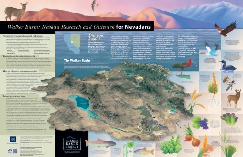
Walker Basin: <strong>Nevada</strong> Research and Outreach for <strong>Nevada</strong>ns<br />
Public universities and research institutions<br />
In <strong>Nevada</strong>, the <strong>University</strong> <strong>of</strong> <strong>Nevada</strong>, <strong>Reno</strong> and the Desert Research Institute help us to understand<br />
the interrelationships among people, other living organisms and the environment. Both institutions<br />
have made a strong commitment to increasing our understanding <strong>of</strong> the Walker Basin ecosystem<br />
and its water resources in order to protect and conserve them into the future.<br />
As the state’s land-grant institution, UNR also provides applied research and outreach through<br />
Cooperative Extension, with <strong>of</strong>fices in every county.<br />
Our two institutions serve <strong>Nevada</strong> and the entire Walker Basin by providing outreach, expertise,<br />
knowledge and leadership in the areas <strong>of</strong>:<br />
:: hydrology :: economic sustainability :: identification and control <strong>of</strong> both<br />
:: aquatic ecology :: alternative agriculture<br />
terrestrial and aquatic invasive species<br />
:: land restoration<br />
:: plant, soil and water interactions<br />
Sharing knowledge and working together<br />
In addition to activities such as short courses, workshops, field tours and other outreach programs,<br />
the <strong>University</strong> <strong>of</strong> <strong>Nevada</strong>, <strong>Reno</strong> and Desert Research Institute scientists <strong>of</strong>ten work directly with local<br />
and regional agencies. For example, scientists are working with the U.S. Fish and Wildlife Service and the<br />
Walker River Paiute Tribe to remove invasive tamarisk, a deciduous shrub, from around the lake to restore<br />
wildlife habitat and conserve water. Although these and other efforts face many challenges, applied<br />
science is not only essential but also exciting when it contributes to improving the quality <strong>of</strong> life in the<br />
Walker Basin by improving the local ecosystems on which people and wildlife depend.<br />
CALIFORNIA<br />
NEVADA<br />
WALKER BASIN<br />
Did you<br />
know<br />
Walker Lake was once<br />
part <strong>of</strong> ancient Lake<br />
Lahontan, which covered<br />
much <strong>of</strong> northern and<br />
central <strong>Nevada</strong> including<br />
Pyramid Lake.<br />
The Walker Basin<br />
The view below looks south across Walker Basin. The image was created using Geographic Information Systems or GIS.<br />
GIS allows scientists to collect, store, analyze and display geographic and spatial data. GIS is excellent for combining and integrating<br />
information from multiple sources to help scientists understand complex systems in new and powerful ways. For the Walker Basin,<br />
scientists collect data from many sources including historical photographs, satellite imagery and field experiments to produce<br />
databases for the entire Walker Basin. These data can then be combined and analyzed to learn how water flows through the system,<br />
the productivity <strong>of</strong> the surrounding lands and the efficacy <strong>of</strong> restoration treatments such as tamarisk removal.<br />
Lake level has varied over<br />
time and the lake has dried<br />
up several times since the end<br />
<strong>of</strong> the Pleistocene (12,000<br />
years ago); this was most<br />
likely caused by natural<br />
diversions <strong>of</strong> the Walker River<br />
through Adrian Valley near<br />
Wabuska into the Carson<br />
River drainage. In the last<br />
100 years, over allocation <strong>of</strong><br />
upstream diversions have also<br />
contributed to these declines.<br />
Walker Lake historically<br />
supported populations<br />
<strong>of</strong> native fish, including<br />
Lahontan redside, speckled<br />
dace, Tahoe sucker, tui chub<br />
and a thriving, naturally<br />
reproducing population <strong>of</strong><br />
large Lahontan cutthroat<br />
trout. However, water levels<br />
have dropped over 150<br />
feet in the past 100 years,<br />
SIERRA NEVADA MOUNTAINS<br />
resulting in an increase <strong>of</strong><br />
total dissolved solids (i.e.,<br />
salts) that threaten the lake’s<br />
ecosystem, including<br />
the threatened Lahontan<br />
cutthroat trout.<br />
Walker Basin is primarily<br />
situated in Lyon County,<br />
<strong>Nevada</strong>. The market value <strong>of</strong><br />
agricultural products sold in<br />
Lyon County, according to the<br />
2007 agriculture census, was<br />
$91 million dollars, about 18<br />
percent <strong>of</strong> the <strong>Nevada</strong> total.<br />
Walker Lake has historically<br />
been an important site for<br />
migrating birds like the<br />
common loon.<br />
Loons foraged on the lake<br />
to replenish their energy<br />
reserves while on their way<br />
to breeding grounds<br />
in Canada.<br />
American white pelicans<br />
(Pelecanus erythrorhynchos) are four to<br />
five feet in length. They catch prey<br />
while swimming so are vulnerable<br />
to environmental changes including<br />
declining water levels as a result<br />
<strong>of</strong> drought. Anaho Island, located<br />
at Pyramid Lake, <strong>Nevada</strong>, supports<br />
one <strong>of</strong> the largest breeding colonies<br />
<strong>of</strong> American White Pelicans<br />
in the Western United States.<br />
The bald eagle (Haliaeetus leucocephalus)<br />
is the national bird <strong>of</strong> the United States.<br />
This large bird <strong>of</strong> prey is about three feet tall<br />
with a wingspan <strong>of</strong> six to seven feet.<br />
Its diet mainly consists <strong>of</strong> fish.<br />
Common loons (Gavia immer) previously staged<br />
at Walker lake for about 30 days during<br />
the spring and fall. They migrate south for<br />
the winter from nesting grounds in Canada.<br />
Walker Lake was the site <strong>of</strong> the annual Loon Festival.<br />
However, loon numbers at Walker Lake have<br />
fallen dramatically since 1997, from a high <strong>of</strong> 1,433<br />
during the spring <strong>of</strong> 1997 to 73 during<br />
the spring <strong>of</strong> 2011.<br />
What’s it like to be a university researcher<br />
Scientists are curious and want to understand the world. To do this, they conduct research.<br />
What do you think <strong>of</strong> when you hear the word research White lab coats Test tubes Microscopes Sometimes<br />
research happens in a laboratory, but very <strong>of</strong>ten, research happens outdoors.<br />
For researchers at the Desert Research Institute and the <strong>University</strong> <strong>of</strong> <strong>Nevada</strong>,<br />
<strong>Reno</strong>, the Walker Basin is a large outdoor laboratory. Researchers test soil,<br />
water and air samples; they study how crop changes might affect the local<br />
economy; they look for animals and plants that aren’t supposed to be there (also<br />
called invasive species); they talk to people; and they study how the environment has<br />
changed over time. <strong>University</strong> researchers in the Walker Basin<br />
work to answer important questions about the health<br />
<strong>of</strong> the lake and river, watershed management, land<br />
restoration, invasive species, low water-use alternative crop<br />
types, the amount and timing <strong>of</strong> water flow and how these factors<br />
interact to protect and preserve the natural spaces that we call home.<br />
HAWTHORNE ARMY DEPOT<br />
MOUNT GRANT<br />
BRIDGEPORT<br />
BRIDGEPORT RESERVOIR<br />
COLEVILLE<br />
ANTELOPE VALLEY<br />
The white-faced ibis (Plegadis chihi)<br />
is a wading bird found in the Walker Basin.<br />
Basin wildrye (Leymus cinereus)<br />
is a grass native to the western<br />
U.S. and Canada. In addition<br />
to its potential for livestock<br />
grazing, it is used extensively<br />
for range rehabilitation<br />
following wildfires.<br />
The stonefly (Plecoptera)<br />
is an aquatic insect that<br />
is also a food source for the<br />
Lahontan cutthroat trout.<br />
Preserving the Walker Basin<br />
HAWTHORNE<br />
TOPAZ LAKE<br />
WEST WALKER RIVER<br />
The Walker Basin provides a rich landscape for the community, including<br />
farmers and ranchers, fishermen, hunters, recreation enthusiasts such as<br />
boaters and hikers, and those seeking a small-town way <strong>of</strong> life. Abundant wildlife<br />
inhabit the basin including migratory birds that stop over at Walker Lake; it is also home to the<br />
native Lahontan cutthroat trout, a federally-listed threatened species.<br />
For millennia, the Walker Basin has supported settlements, with humans occupying the area as long as<br />
11,000 years ago. The Walker River Paiute Reservation includes 40+ miles <strong>of</strong> the Walker River. Now, a<br />
declining lake and overtaxed water resources have put livelihoods and ecosystems in jeopardy. With<br />
the Walker Basin water resources diverted for many uses, there is insufficient water flow remaining to<br />
maintain the lake, causing the lake level to drop drastically over the last 150 years. The lake shore<br />
has receded by as much as seven miles since 1882 and lake salinity has greatly increased. This<br />
increase in salinity has already harmed the lake’s distinctive fishery, one <strong>of</strong> only three freshwater<br />
terminus lake fisheries in North America.<br />
WALKER LAKE<br />
RECENT HISTORICAL<br />
EXTENT OF WALKER<br />
LAKE ><br />
EAST WALKER RIVER<br />
WELLINGTON<br />
SMITH VALLEY<br />
ARTESIA LAKE<br />
Two-row malt barley<br />
(Hordeum vulgare var. distichum) is an<br />
annual cereal grain. It ranks fourth in the world in<br />
terms <strong>of</strong> quantity produced and area <strong>of</strong> cultivation.<br />
It is grown as a major source <strong>of</strong> animal feed with<br />
smaller amounts used for malting intended for<br />
beer and ale production.<br />
Mule deer (Odocoileus hemionus) are found throughout<br />
the United States. The mule deer was first described<br />
by Lewis and Clark in 1804. Because <strong>of</strong> the size <strong>of</strong> its ears,<br />
they gave it the name “mule deer.”<br />
Researchers at the <strong>University</strong> <strong>of</strong> <strong>Nevada</strong>, <strong>Reno</strong> and the Desert Research Institute are<br />
investigating how to preserve the lake and river ecosystems without adversely impacting<br />
the existing local economy. The Walker Basin Restoration Program, administered by the<br />
National Fish and Wildlife Foundation, hopes to increase water flow within the river and into<br />
the lake by purchasing and leasing water rights from willing sellers, in combination with land<br />
stewardship activities and a focus on keeping the agricultural base intact.<br />
Research on low water-use alternative crops and restoration, and alternative economic<br />
strategies may provide options for a sustainable and vibrant ecosystem and economy, with<br />
the goal <strong>of</strong> supporting the continuation <strong>of</strong> a high quality <strong>of</strong> life for Walker Basin communities.<br />
SCHURZ<br />
WALKER RIVER INDIAN RESERVATION<br />
WEBER RESERVOIR<br />
YERINGTON<br />
MASON VALLEY<br />
WABUSKA<br />
N<br />
Grapes (Vitis vinifera),<br />
are a potentially pr<strong>of</strong>itable<br />
agricultural crop alternative to<br />
alfalfa. Grapes consume less<br />
than one-tenth <strong>of</strong> the water<br />
typically required by alfalfa<br />
or grass hay, while also<br />
providing a higher estimated<br />
net pr<strong>of</strong>it per acre.<br />
Also known as “spring mix,” a number<br />
<strong>of</strong> varieties <strong>of</strong> baby leaf lettuce (Lactuca sativa)<br />
and spinach (Spinacia oleracea) are currently grown<br />
in Mason Valley. Spring mix requires one-fourth<br />
<strong>of</strong> the irrigation water per crop compared to alfalfa. However,<br />
multiple crops are commonly grown in one season.<br />
WALKER RIVER<br />
ADRIAN VALLEY<br />
The Walker Basin Research Project is supported by the Bureau <strong>of</strong> Reclamation (#R10-AC-20628) and<br />
the National Fish and Wildlife Foundation’s Walker Basin Restoration Program (#2010-0059-201).<br />
Development <strong>of</strong> this poster was supported with funds provided by BOR.<br />
<strong>University</strong> <strong>of</strong> <strong>Nevada</strong>, <strong>Reno</strong> 1664 N. Virginia Street, <strong>Reno</strong>, NV 89557 775-784-1110<br />
www.unr.edu Apply: www.unr.edu/admissions<br />
Desert Research Institute 2215 Raggio Parkway, <strong>Reno</strong>, NV 89512 775-673-7300 www.dri.edu<br />
P R O D U C E D B Y<br />
The Academy for the Environment,<br />
<strong>University</strong> <strong>of</strong> <strong>Nevada</strong>, <strong>Reno</strong> http://environment.unr.edu<br />
The Center for Watersheds and Environmental Sustainability,<br />
Desert Research Institute http://cwes.dri.edu<br />
Designed and illustrated by Michael Hagelberg; Photography by Jean Dixon<br />
Assisted and edited by Jake Kupiec; Technical assistance by Christina Clack<br />
GIS images provided by Scott Bassett and Doug Boyle, Department <strong>of</strong> Geography, UNR<br />
Compiled by Mike Collopy, Wally Miller, Jim Thomas, Alan Heyvaert and Chris Briggs<br />
No state funds were used in the production <strong>of</strong> this publication<br />
<strong>Download</strong> this <strong>map</strong> and learn more about the Walker Basin Project from<br />
http://environment.unr.edu/walker<br />
The Lahontan cutthroat trout<br />
(Oncorhynchus clarki henshawi) is a large and long-lived<br />
predatory fish that is native to the Walker River.<br />
This threatened species is also the state fish <strong>of</strong> <strong>Nevada</strong>.<br />
Phytoplankton serve<br />
as the most basic food<br />
source for marine and<br />
freshwater animals<br />
and account for half <strong>of</strong> all<br />
photosynthetic<br />
activity on Earth.<br />
The Tui chub (Gila bicolor) is native to western<br />
North America and is a primary forage fish for<br />
the Lahontan cutthroat trout and migrating birds.<br />
In 2012, over<br />
240,000 acres <strong>of</strong><br />
alfalfa (Medicago<br />
sativa) were grown<br />
in <strong>Nevada</strong>. Alfalfa<br />
hay is used as a<br />
food source for<br />
livestock.<br />
Onions (allium cepa) are a major<br />
agricultural crop in <strong>Nevada</strong>,<br />
one <strong>of</strong> the top five commodities<br />
for the state in 2012.<br />
Teff (Eragrostis tef),<br />
an annual grass native<br />
to the northern Ethiopian<br />
Highlands, is a promising<br />
low-water use crop in<br />
the Walker Basin.<br />
Teff is a high protein grain<br />
used to make a flat bread<br />
called injera and is an<br />
alternative for people with<br />
wheat (gluten) allergies.<br />
Switchgrass (Panicum virgatum)<br />
is a hardy, deep-rooted, perennial grass<br />
that can be used for bi<strong>of</strong>uel production.
university Research and Outreach: Improving Life in <strong>Nevada</strong><br />
Plant, soil and water interactions<br />
Alfalfa is currently a popular crop in the Walker Basin;<br />
alfalfa is also a high water use crop. Research is<br />
being conducted on alternatives to alfalfa that are<br />
both viable in this climate and pr<strong>of</strong>itable for local<br />
farmers. However, alternative crops for food production,<br />
such as teff, amaranth and pearl millet, as well as crops for<br />
bi<strong>of</strong>uels production, will alter the ecosystem.<br />
It is important to understand how new crop<br />
types may change soil properties over time.<br />
Alternative crops, for example, may change carbon<br />
and nitrogen cycling in the soils, which are important<br />
components <strong>of</strong> soil fertility. Therefore, scientists are<br />
interested in how changes in water use, water table<br />
depth and soil salinity would<br />
affect both soils and vegetation.<br />
Irrigation <strong>of</strong> cropland can deposit large amounts<br />
<strong>of</strong> salts in the soil. Over time, these salts<br />
can accumulate in the soil and impact the agricultural<br />
crop production and native vegetation restoration.<br />
High salinity can be detrimental to plant health<br />
because it makes it difficult for plants to extract water<br />
from the soil.<br />
As water rights are transferred and land is<br />
taken out <strong>of</strong> agricultural production, fields that<br />
were previously irrigated and farmed are <strong>of</strong>ten<br />
abandoned. These areas can become infested with<br />
weeds and eventually even degrade to a barren state<br />
that is susceptible to erosion. Wind erosion, and the<br />
associated increase in dust, can cause respiratory<br />
health problems, increase sediments in waterways<br />
and cause property damage. Researchers have<br />
determined that even small amounts <strong>of</strong> water can<br />
have a significant impact on the re-establishment<br />
<strong>of</strong> native plant species used for restoration <strong>of</strong><br />
areas taken out <strong>of</strong> production. By restoring native<br />
vegetation and reducing invasive weed species,<br />
scientists hope to restore wildlife habitat, prevent<br />
topsoil erosion and maintain good water quality in<br />
the basin. Restoring native vegetation helps protect<br />
the land, air and waterways.<br />
Alternative agriculture for water<br />
conservation in the Walker Basin<br />
In the West, the demand for limited water resources<br />
<strong>of</strong>ten exceeds availability. Because agricultural<br />
water use is a significant portion <strong>of</strong> all water used,<br />
the search for water savings is commonly directed<br />
towards irrigated agriculture. Reducing water<br />
use while maintaining a sustainable agricultural<br />
economy is a significant challenge.<br />
Researchers from the <strong>University</strong> <strong>of</strong> <strong>Nevada</strong>,<br />
<strong>Reno</strong> and the Desert Research Institute are actively<br />
studying the potential use <strong>of</strong> alternative crops,<br />
biomass production, restoration, soil management,<br />
water use efficiency and irrigation scheduling to<br />
conserve water in the Walker Basin. Crops such as<br />
Basin wildrye, grain amaranth, teff and buckwheat,<br />
Irrigation scheduling<br />
Using crops that require less water is just one strategy<br />
to conserve water in the Walker Basin. Another<br />
method is to more efficiently use the water that<br />
is available. Overwatering wastes water, causes<br />
nutrients to run<strong>of</strong>f or leach into the ground and<br />
can cause salinity problems in the soil. Under<br />
watering can cause stress on crops and reduce<br />
yields.<br />
Researchers are using fiber optic cable<br />
that can take continuous measurements <strong>of</strong> soil<br />
temperature, which is directly related to soil<br />
moisture content.<br />
Historical vegetation patterns<br />
Researchers used written descriptions by early<br />
explorers, historical photographs and land surveys<br />
to reconstruct what the Walker Basin looked like<br />
prior to agricultural development. They then<br />
compared these results to what we see today,<br />
using aerial photos and on-the-ground <strong>map</strong>ping,<br />
to determine if some plant communities were<br />
more affected than others by the development <strong>of</strong><br />
the basin.<br />
Agriculture was introduced to the Walker<br />
Basin in the 1850s. Irrigated agriculture, grazing<br />
and invasive species have all contributed to<br />
changes in the landscape during the past 150<br />
years. Walker Basin was once used to graze cattle<br />
and harvest wild hay. Gradually, areas were<br />
converted to higher quality hay, such as alfalfa.<br />
As irrigation techniques improved, larger<br />
areas were used for farming and some <strong>of</strong> the most<br />
productive natural areas (wet meadows, sagebrush<br />
and grasslands) were cleared and leveled. The<br />
channelization <strong>of</strong> the river, ground water pumping<br />
and intensive grazing dried out the surrounding<br />
lands. This shifted the plant communities towards<br />
plants that were more adapted to drier conditions;<br />
approximately 44 percent <strong>of</strong> the meadow and<br />
wetland areas were changed to shrubland as a<br />
result <strong>of</strong> these drier conditions. Another 41 percent<br />
hold promise in reducing the amount <strong>of</strong> water<br />
needed to raise economically viable crops. Reducing<br />
water use would create the potential for growers to<br />
lease or sell remaining water rights to help replenish<br />
and restore both the Walker River and Walker Lake.<br />
Scientists working in the Walker Basin<br />
have shown that growth rates <strong>of</strong> some plant<br />
species exhibit a potential for water savings.<br />
Scientists tested 24 varieties <strong>of</strong> 22 crop types to<br />
determine which non-traditional crops might be<br />
agronomically and economically feasible in the<br />
Walker Basin. New, economical methods for water<br />
use monitoring can also help prevent overwatering<br />
and conserve water resources.<br />
This system can examine soil temperature at<br />
long distances, up to five miles (eight kilometers),<br />
or at three- to six-foot (one- to two-meter)<br />
increments across a field, allowing a producer to<br />
know what areas <strong>of</strong> the field need more water and<br />
which areas need less.<br />
By increasing water use efficiency through<br />
more informed irrigation scheduling, farmers<br />
can increase their revenues by using less water<br />
and selling or leasing unused water to increase<br />
flows <strong>of</strong> the Walker River.<br />
<strong>of</strong> the wetlands and meadows were directly<br />
converted to support agricultural production.<br />
Cottonwood trees became more prevalent in<br />
the Walker Basin as the valley was settled, especially<br />
near homesteads. However, cottonwoods have<br />
largely stopped regenerating in the Walker Basin<br />
since the mid-20th century due to flood control;<br />
floods are necessary for cottonwood seedling<br />
establishment. Despite increases in cottonwoods<br />
in most areas, they have declined along the lower<br />
reaches <strong>of</strong> the Walker River, likely a result <strong>of</strong> the<br />
dropping water table that occurred partly due to<br />
river incision as the result <strong>of</strong> the dropping lake<br />
level. Plant communities have changed<br />
noticeably since the beginning <strong>of</strong> the 20th century,<br />
with large amounts <strong>of</strong> land shifting from wet<br />
to dry conditions.<br />
Economic impact<br />
Changing how water is allocated and used in any<br />
environment can have both positive and negative<br />
effects. The acquisition <strong>of</strong> water rights from willing<br />
sellers to help restore the Walker River ecosystem<br />
and replenish Walker Lake also can have unintended<br />
consequences. Researchers studied the potential<br />
impacts <strong>of</strong> water being purchased from agricultural<br />
sources noting the economic effect <strong>of</strong> taking some<br />
agricultural land out <strong>of</strong> production or switching to<br />
crops with lower water use. Researchers examined<br />
several different scenarios where producers could<br />
improve their water-use efficiency or grow crops<br />
that require less water without causing economic<br />
hardship. These studies investigated a number <strong>of</strong><br />
crops that were less water-intensive than current<br />
crops and were likely to be more pr<strong>of</strong>itable, such<br />
as baby head lettuce, spinach, two-row malt barley,<br />
teff and grapes.<br />
Walker River<br />
In the 1800s, the Walker River annually delivered<br />
an average <strong>of</strong> about 300,000 acre-feet (370,000,000<br />
cubic meters) <strong>of</strong> water to Walker Lake, but diversions<br />
and drought have decreased that amount to<br />
approximately 117,000 acre-feet (145,000,000 cubic<br />
meters) per year. This decreased flow has affected<br />
the chemistry and ecology <strong>of</strong> the Walker River.<br />
Historically, the river provided refuge for fish species<br />
when lake conditions became unfavorable, so<br />
it was an important resource for lake fish species.<br />
However, important changes have occurred<br />
along the river since historic times.<br />
Alternative crops<br />
Crops that have not been<br />
typically planted in the Walker<br />
Basin, but require less water<br />
or are more efficient at using<br />
water.<br />
The construction <strong>of</strong> dams, the diversion<br />
<strong>of</strong> water for irrigation and nutrient run<strong>of</strong>f from<br />
agriculture all have contributed to environmental<br />
changes along the river. The shape <strong>of</strong> the channel<br />
has also been affected by these changes, resulting<br />
in increased sedimentation. Researchers are<br />
Benthic macro invertebrates<br />
Organisms without<br />
backbones that live in or<br />
on the sediments <strong>of</strong> a body<br />
<strong>of</strong> water, such as clams<br />
and immature insects like<br />
stoneflies and mayflies.<br />
Biomass production<br />
Certain crops, such as<br />
switchgrass, that are fastgrowing<br />
and cost-efficient<br />
can be used to make fuels<br />
such as ethanol, an alternative<br />
to petroleum-based fuels.<br />
Cheatgrass<br />
(Bromus tectorum)<br />
An annual grass native to<br />
Europe and parts <strong>of</strong> Africa<br />
and Asia that has invaded areas<br />
<strong>of</strong> western North America.<br />
Economic impact The effect<br />
<strong>of</strong> decisions, policies or events<br />
on the employment rates<br />
and/or incomes <strong>of</strong> an area.<br />
Groundwater Water located<br />
beneath the ground surface<br />
in the soil or rock spaces.<br />
Headwater The place from<br />
which a stream or river<br />
originates.<br />
Hydrograph Graph showing<br />
the discharge <strong>of</strong> a river over<br />
time.<br />
Invasive species<br />
Invasive species are organisms and plants that do<br />
not occur in an area naturally and can be economically<br />
or ecologically harmful. These species are generally<br />
difficult to control once established and become<br />
problematic for people and other organisms. The<br />
Walker Basin has been greatly affected by invasive<br />
species. Some—like cheatgrass—were introduced<br />
accidentally. Others, such as brown trout, were<br />
intentionally introduced. Whether intentional or<br />
unintentional, invasive species can outcompete or<br />
destroy native populations.<br />
One especially problematic invasive species is<br />
tamarisk, or salt cedar. Tamarisk is a deciduous shrub<br />
or small tree that has very long taproots that allow it<br />
to access deep groundwater. Large plants can absorb<br />
up to 200 gallons <strong>of</strong> water per day; water that could<br />
be used for agriculture or to increase river flows and<br />
lake level. Tamarisk’s needles have a salty excretion<br />
that make the surrounding soil unproductive for<br />
native vegetation. It provides poor wildlife habitat<br />
Decision Support Tool<br />
If water demands in the Walker Basin are going<br />
to be balanced among agricultural and ecosystem<br />
needs, it is necessary to evaluate the effectiveness<br />
<strong>of</strong> increasing river flows and maintaining a lake level<br />
sufficient for Lahontan cutthroat trout survival.<br />
In order to understand how much water will reach<br />
Walker Lake under different water right acquisition<br />
strategies and under different climatic conditions,<br />
a computer-based Decision Support Tool (DST)<br />
was developed. The DST model uses Walker River<br />
flows at U.S. Geological Survey (USGS) gauging<br />
sites along the river, geographic information<br />
systems (GIS) and satellite imagery to model<br />
the hydrological complexities and interactions<br />
<strong>of</strong> climate, evapotranspiration, river flows,<br />
groundwater-surface water exchange, irrigation<br />
practices and groundwater pumping. These models<br />
help researchers to estimate how much water<br />
is in the river and how much reaches the lake.<br />
Researchers modeled 1,341 square miles (3,214<br />
square kilometers) <strong>of</strong> the Walker Basin to account for<br />
headwater supply and to model differences in river<br />
flows with different climatic patterns. This allows users<br />
to track water from the headwaters, where stream<br />
flow originates, through the complicated deliveries<br />
and returns in the irrigated areas <strong>of</strong> Antelope,<br />
Smith and Mason valleys. The DST model will help<br />
researchers, the Walker River Irrigation District,<br />
interested groups and organizations, and the<br />
public to evaluate potential water rights acquisition<br />
scenarios for delivering water to Walker Lake.<br />
working to provide the information needed to<br />
restore and maintain a natural and healthy riparian<br />
(river) ecosystem in the face <strong>of</strong> droughts and human<br />
use. Researchers studied several aspects <strong>of</strong> the<br />
ecology <strong>of</strong> the river; specifically they examined<br />
the algae, benthic macroinvertebrates and fish<br />
communities along several areas <strong>of</strong> both the East<br />
and West Walker Rivers.<br />
Benthic macroinvertebrates—organisms<br />
without a backbone that live in or on the<br />
sediments <strong>of</strong> the river—provide the foundation<br />
for the aquatic food web. The presence and<br />
abundance <strong>of</strong> these organisms are related to lower<br />
water temperatures, higher river flows and lower<br />
nutrient levels. Increasing river flow helps to lower<br />
temperatures, and may in turn help the benthic<br />
macroinvertebrates and improve the health<br />
<strong>of</strong> the river’s ecosystem.<br />
[ g l o s s a r y ]<br />
Hydrology The study <strong>of</strong><br />
the quantity, distribution<br />
and movement <strong>of</strong> water.<br />
Invasive species<br />
A non-native species<br />
whose introduction causes,<br />
or is likely to cause, economic<br />
or environmental harm.<br />
Irrigation scheduling<br />
The decision <strong>of</strong> when and<br />
how much water to apply<br />
to a field with the intent<br />
<strong>of</strong> maximizing water use<br />
efficiency.<br />
Market development<br />
A process for developing<br />
business by entering new<br />
segments <strong>of</strong> the market<br />
or converting non-users<br />
into users.<br />
Mesic An area with moderate<br />
or a well-balanced supply<br />
<strong>of</strong> moisture.<br />
Plant community<br />
A collection <strong>of</strong> plant species<br />
within a geographic area that<br />
is influenced by soil type,<br />
topography, climate and<br />
human disturbance.<br />
because its needles and seeds are not nutritious.<br />
Tamarisk was likely introduced in the Walker River<br />
Basin in the early 1900s for erosion control and<br />
wind breaks, and spread rapidly. It is now common<br />
throughout the lower Walker River area and around<br />
Walker Lake.<br />
Limnology<br />
Limnology refers to the study <strong>of</strong> bodies <strong>of</strong> fresh<br />
water. Walker Lake is one <strong>of</strong> only six large, natural<br />
inland terminal lakes in western North America. It<br />
is experiencing a long-term decline in lake volume<br />
due to limited water delivery, decreasing about<br />
150 feet (43 meters) and from about 10 million to<br />
less than two million acre-feet since the late 1800s.<br />
Limnologists (scientists that study inland waters,<br />
such as lakes) studied Walker Lake to determine<br />
physical, chemical and biological parameters<br />
<strong>of</strong> the lake at different depths over time. The<br />
interactions <strong>of</strong> these factors determine the lake’s<br />
ecology. For example, as the lake level became<br />
lower, the concentration <strong>of</strong> salts increased making<br />
the lake inhospitable to many species <strong>of</strong> fish<br />
because the increasing osmotic stress prevented<br />
their young from developing. Lake salinity has<br />
increased over six-fold due to the decrease in lake<br />
volume, causing significant declines in survival<br />
and reproduction rates <strong>of</strong> two fishes from the lake,<br />
the tui chub and the Lahontan cutthroat trout.<br />
Similarly, as the lake warms, because it has less<br />
volume, the oxygen content declines in the cooler<br />
bottom waters where trout persist in the summer.<br />
These changes in lake conditions threaten the<br />
survival <strong>of</strong> native trout and their primary prey, the<br />
tui chub.<br />
The Walker Lake Paiute Tribe has over 1,000<br />
acres (400 hectares) <strong>of</strong> tamarisk that use about 4,000<br />
acre-feet (five million cubic meters) <strong>of</strong> water per year.<br />
Unfortunately, tamarisk is extremely hard<br />
to remove once established. It readily re-sprouts<br />
when cut down or burned and the salty soil it creates<br />
makes re-establishment <strong>of</strong> many native species<br />
difficult. The U.S. Fish and Wildlife Service and the<br />
Paiute Tribe are working together to remove 80<br />
acres <strong>of</strong> tamarisk. They are testing different removal<br />
techniques in the hope <strong>of</strong> finding effective ways<br />
to make areas with tamarisk more productive for<br />
wildlife and other native species.<br />
The lake exhibits holomixis (complete<br />
mixing <strong>of</strong> the layers <strong>of</strong> the lake) during winter and<br />
stratification (separation <strong>of</strong> the lake into thermal<br />
layers) during summer—both are important<br />
processes to maintain a healthy lake ecosystem.<br />
These processes allow the lake to turn over and<br />
distribute nutrients throughout the lake.<br />
By examining the algae, invertebrates and<br />
fish in the lake, investigators learned more about<br />
its ecological health. Researchers found that<br />
algae levels were highest in the summer and<br />
there were only two native species <strong>of</strong> fish species<br />
still present in the lake, compared to five native<br />
species in neighboring terminal lakes. Algae and<br />
invertebrates produced in the open water were<br />
not an important food source for the two species<br />
<strong>of</strong> native fish; instead, these fish get most <strong>of</strong> their<br />
food from the lake’s benthic zone, the lowest<br />
part <strong>of</strong> the lake or lake bottom. These data have<br />
allowed researchers to create an ecological model<br />
that will help them understand how to better<br />
manage the lake in the future.<br />
Riparian Area <strong>of</strong> interface<br />
between the land and a river<br />
or stream. Because <strong>of</strong> their<br />
proximity to water, plant<br />
communities in riparian areas<br />
are <strong>of</strong>ten much different than<br />
the surrounding upland area.<br />
Salinity The saltiness,<br />
or dissolved salt content,<br />
<strong>of</strong> a body <strong>of</strong> water or soil.<br />
Satellite imagery<br />
Photographs <strong>of</strong> the Earth<br />
from an orbiting satellite.<br />
These images can record<br />
different spectral ranges<br />
<strong>of</strong> light: the visible light<br />
spectrum; light <strong>of</strong> higher<br />
energy than the visible<br />
spectrum (ultraviolet); or<br />
lower energy (infrared or<br />
heat).<br />
Surface water Water that<br />
collects on the ground,<br />
including streams, rivers,<br />
lakes, wetlands and oceans.<br />
What is a geographic information system<br />
Tamarisk Comprises about<br />
50-60 species <strong>of</strong> deciduous<br />
shrub or small tree native to<br />
Eurasia and Africa that have<br />
very long taproots allowing it<br />
access to deep groundwater;<br />
considered to be an invasive<br />
species in the Walker Basin.<br />
Taproot An enlarged<br />
root that grows vertically<br />
downward (like<br />
a carrot) which can serve<br />
as storage for energy or to<br />
provide access to deep water<br />
resources.<br />
Teff An annual grass native<br />
to the northern Ethiopian<br />
Highlands.<br />
Water rights The right<br />
to use a specified amount <strong>of</strong><br />
water from a particular source<br />
(e.g., river, stream, pond, etc.).<br />
Water savings An amount<br />
<strong>of</strong> water that can be saved<br />
as a result <strong>of</strong> changing wateruse<br />
practices, for example,<br />
switching to crops that<br />
require less water.<br />
Water table The top <strong>of</strong><br />
an underground surface<br />
in which the soil or rocks<br />
are permanently saturated<br />
with water, separating the<br />
groundwater zone that lies<br />
below it from the zone <strong>of</strong><br />
aeration that lies above it.<br />
Xeric An area or environment<br />
that is extremely dry.<br />
Zone <strong>of</strong> aeration The area<br />
above the water table where<br />
spaces between rocks and<br />
sediments contain both air<br />
and water.<br />
[ g i s ]<br />
[ r e s o u r c e s ]<br />
http://www.ag.unr.edu/cramer/GrapePr<strong>of</strong>itability.ppt<br />
http://www.nasa.gov/topics/earth/features/modis_fluorescence.html<br />
http://agri.nv.gov/<br />
http://www.ers.usda.gov/StateFacts/NV.htm<br />
http://www.agclassroom.org/nv/teacher/pdf/poster/onions.pdf<br />
http://www.unce.unr.edu/publications/<br />
http://environment.unr.edu/walker/downloads/2010-Walker-Report-Project-H.pdf<br />
http://www.ndow.org/Species/Birds/American_White_Pelican/<br />
http://www.ndow.org/Species/Furbearer/Mule_Deer/<br />
http://www.baldeagleinfo.com/eagle/eagle-facts.html<br />
http://www.agcensus.usda.gov<br />
More commonly known by its acronym, GIS is a tool<br />
used to relate spatial, temporal and tabular data,<br />
such as rainfall totals, population statistics or<br />
land use, for a common geographic study area.<br />
“GIS is a collection <strong>of</strong> different types <strong>of</strong> data<br />
that, when georeferenced, provide insight about<br />
various phenomena in the area <strong>of</strong> interest,”<br />
says Tim Minor, a geospatial scientist in the<br />
Division <strong>of</strong> Earth and Ecosystem Sciences at<br />
the Desert Research Institute.<br />
The Walker Basin Project, for example, involved<br />
the integration <strong>of</strong> many spatial and tabular<br />
data sets related to irrigation delivery systems,<br />
the associated streams and rivers, and how<br />
topography, geology and vegetation affected<br />
water flow. “These are the types <strong>of</strong> data we<br />
integrate to help the surface and groundwater<br />
modelers conduct their analyses,” Minor says.<br />
t o p o g r a p h y<br />
GIS researchers gathered a wide variety <strong>of</strong> existing<br />
spatial and tabular data sets from local, state<br />
and federal agencies, but also had to collect new<br />
data. One such data set was high-resolution<br />
Light Detection and Ranging (LiDAR) data,<br />
which uses an active laser system to measure<br />
distance returns from the ground surface back<br />
to the instrument onboard an airplane. LiDAR<br />
data were collected over the major sub-basins in<br />
the Walker River Basin, providing a very detailed<br />
description <strong>of</strong> the area’s topography. Combined<br />
with high-resolution aerial photography and<br />
satellite imagery, this information allowed<br />
the GIS group to create a detailed snapshot<br />
<strong>of</strong> the surface characteristics <strong>of</strong> the sub-basins,<br />
including Mason and Smith valleys.<br />
Researchers constructed an extensive GIS<br />
database <strong>of</strong> the entire Walker Basin,<br />
with data sets from federal, state and local<br />
agencies combined and integrated with<br />
derivative data sets. The result is a scalable,<br />
georeferenced collection <strong>of</strong> spatial data<br />
representing a wide variety <strong>of</strong> spatial and<br />
temporal features, as well as tabular information<br />
for the entire Walker Basin. The principal<br />
base layer for the development, processing<br />
and analysis was one-foot natural color aerial<br />
photography, complemented by six-inch<br />
resolution imagery <strong>of</strong> the Yerington area.<br />
w a t e r s y s t e m<br />
GIS provides an effective tool for integrating data<br />
related to irrigation delivery systems, serviced<br />
agricultural fields, and the water rights that<br />
control the distribution <strong>of</strong> water. Surface and<br />
groundwater parameters are combined to<br />
provide a better understanding <strong>of</strong> the various<br />
sources <strong>of</strong> irrigation water and the subsequent<br />
distribution <strong>of</strong> these waters for agricultural use.<br />
Agricultural fields serviced by a common<br />
delivery mechanism (irrigation ditch or wells)<br />
can be aggregated into hydrologic response units<br />
(HRUs) to assist modelers in the characterization<br />
<strong>of</strong> the delivery system and the water balance.<br />
i n f r a s t r u c t u r e<br />
To help create a complete picture <strong>of</strong> the various<br />
spatial and tabular data that characterize<br />
the study area, infrastructure data such as<br />
parcels, the Public Land Survey System (PLSS),<br />
landownership, roads and administrative<br />
boundaries are also integrated into the<br />
GIS database. This type <strong>of</strong> data allows the<br />
researchers to relate topographic, hydrologic,<br />
and vegetation phenomena to specific <strong>map</strong> units<br />
and properties in the study area.<br />
These three data sets, when combined, produce<br />
a composite image as displayed on the front<br />
<strong>of</strong> this poster.