Digital Climatic Atlas of Texas - Texas Water Development Board
Digital Climatic Atlas of Texas - Texas Water Development Board
Digital Climatic Atlas of Texas - Texas Water Development Board
Create successful ePaper yourself
Turn your PDF publications into a flip-book with our unique Google optimized e-Paper software.
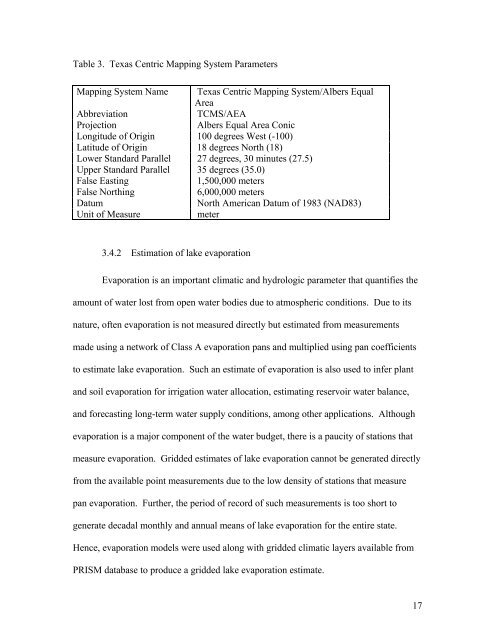
Table 3. <strong>Texas</strong> Centric Mapping System Parameters<br />
Mapping System Name <strong>Texas</strong> Centric Mapping System/Albers Equal<br />
Area<br />
Abbreviation<br />
TCMS/AEA<br />
Projection<br />
Albers Equal Area Conic<br />
Longitude <strong>of</strong> Origin 100 degrees West (-100)<br />
Latitude <strong>of</strong> Origin 18 degrees North (18)<br />
Lower Standard Parallel 27 degrees, 30 minutes (27.5)<br />
Upper Standard Parallel 35 degrees (35.0)<br />
False Easting<br />
1,500,000 meters<br />
False Northing<br />
6,000,000 meters<br />
Datum<br />
North American Datum <strong>of</strong> 1983 (NAD83)<br />
Unit <strong>of</strong> Measure<br />
meter<br />
3.4.2 Estimation <strong>of</strong> lake evaporation<br />
Evaporation is an important climatic and hydrologic parameter that quantifies the<br />
amount <strong>of</strong> water lost from open water bodies due to atmospheric conditions. Due to its<br />
nature, <strong>of</strong>ten evaporation is not measured directly but estimated from measurements<br />
made using a network <strong>of</strong> Class A evaporation pans and multiplied using pan coefficients<br />
to estimate lake evaporation. Such an estimate <strong>of</strong> evaporation is also used to infer plant<br />
and soil evaporation for irrigation water allocation, estimating reservoir water balance,<br />
and forecasting long-term water supply conditions, among other applications. Although<br />
evaporation is a major component <strong>of</strong> the water budget, there is a paucity <strong>of</strong> stations that<br />
measure evaporation. Gridded estimates <strong>of</strong> lake evaporation cannot be generated directly<br />
from the available point measurements due to the low density <strong>of</strong> stations that measure<br />
pan evaporation. Further, the period <strong>of</strong> record <strong>of</strong> such measurements is too short to<br />
generate decadal monthly and annual means <strong>of</strong> lake evaporation for the entire state.<br />
Hence, evaporation models were used along with gridded climatic layers available from<br />
PRISM database to produce a gridded lake evaporation estimate.<br />
17


