Into the Pasayten - Washington Trails Association
Into the Pasayten - Washington Trails Association
Into the Pasayten - Washington Trails Association

You also want an ePaper? Increase the reach of your titles
YUMPU automatically turns print PDFs into web optimized ePapers that Google loves.
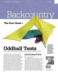
www.wta.org<br />
July+August 2009 » <strong>Washington</strong> <strong>Trails</strong><br />
On Trail<br />
Northwest Explorer »<br />
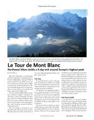
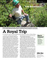
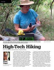
<strong>Into</strong> <strong>the</strong> <strong>Pasayten</strong><br />
A backpacking trip into <strong>the</strong> little-explored central <strong>Pasayten</strong> Wilderness<br />
In my twenty years as a <strong>Washington</strong> <strong>Trails</strong><br />
reader I don’t recall ever seeing a story about<br />
hiking <strong>the</strong> central <strong>Pasayten</strong> Wilderness. Having<br />
done long backpack trips on both <strong>the</strong> western<br />
and eastern fringes of <strong>the</strong> <strong>Pasayten</strong>, I’d always<br />
wondered about that big unknown country in<br />
<strong>the</strong> middle. I knew large portions of it had been<br />
burned over by forest fires in <strong>the</strong> past decade<br />
but hoped <strong>the</strong>re were areas that were spared<br />
and worthy of a visit.<br />
And so, in August 2008, my bro<strong>the</strong>r Keith,<br />
dog Pebbles, and I carefully planned a 6-day<br />
loop trip that took us from Billy Goat trailhead<br />
north to <strong>the</strong> Canadian border and back. We<br />
found this area of <strong>the</strong> <strong>Pasayten</strong> to be incredibly<br />
open, vast, easy to travel, stunningly beautiful,<br />
full of panoramic views, and lonesome. We<br />
experienced a mix of sun, rain, snow, booming<br />
thunder and lightning along <strong>the</strong> way. While<br />
somewhat comparable to Horseshoe Basin in<br />
<strong>the</strong> eastern <strong>Pasayten</strong>, I found that I prefer this<br />
area even more; it’s almost Alaska-like in its appearance<br />
and openness.<br />
Our loop took us north on Billy Goat Trail<br />
over Billy Goat Pass, where it becomes Trail<br />
502. We followed 502, with side detours described<br />
below, about 18 miles north to Peeve<br />
Pass where we did a counterclockwise loop on<br />
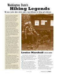
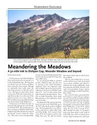
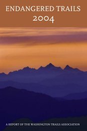
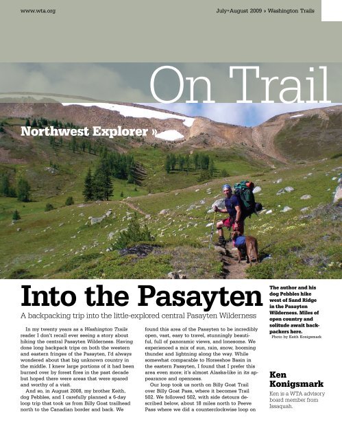
The author and his<br />
dog Pebbles hike<br />
west of Sand Ridge<br />
in <strong>the</strong> <strong>Pasayten</strong><br />
Wilderness. Miles of<br />
open country and<br />
solitude await backpackers<br />
here.<br />
Photo by Keith Konigsmark<br />
Ken<br />
Konigsmark<br />
Ken is a WTA advisory<br />
board member from<br />
Issaquah.
» On Trail July+August 2009 » <strong>Washington</strong> <strong>Trails</strong> www.wta.org<br />
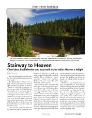
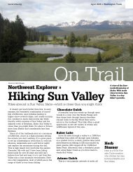
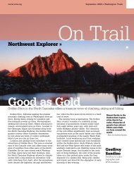
Hiking a side trail to<br />
Corral Lake. High,<br />
open meadows give<br />
<strong>the</strong> landscape an<br />
austere, tundra-like<br />
appearance.<br />
Photo by Ken Konigsmark<br />
Northwest<br />
Explorer articles<br />
describe backpacking<br />
trips in<br />
<strong>the</strong> Northwest<br />
and beyond.<br />
Want to write<br />
about your trip<br />
E-mail editor@<br />
wta.org.<br />
Trail 533 and Trail 529 to Ramon Lakes and<br />
Park Pass and <strong>the</strong>n Trail 506 back to Peeve<br />
Pass. On our return trip, we went cross country<br />
over Sand Ridge near peak 7567 to intersect<br />
<strong>the</strong> dotted line trail that cuts through Whistler<br />
Basin and Whistler Pass and <strong>the</strong>n reconnected<br />
to Trail 502 for <strong>the</strong> return trip to <strong>the</strong> car.<br />
Ano<strong>the</strong>r option is a loop back via <strong>the</strong> Ashnola<br />
River Trail 500 to Trail 514 over Diamond Pass,<br />
but this would have taken us down into a deep,<br />
burned-over river valley that required a steep<br />
climb back up to trail 502.<br />
It was, as expected, very hot when we<br />
started up <strong>the</strong> Billy Goat Trail and, as we<br />
fur<strong>the</strong>r expected from our review of maps<br />
beforehand, <strong>the</strong> trail climbed relentlessly for <strong>the</strong><br />
first 2.7 miles to reach Billy Goat Pass. We were<br />
fully loosened up and covered with sweat by<br />
<strong>the</strong> time we reached <strong>the</strong> pass. After a welcome<br />
downhill walk we noticed a decent campsite<br />
about a mile after crossing <strong>the</strong> pass and o<strong>the</strong>r<br />
possible campsites in <strong>the</strong> mile-long, open notch<br />
of rocky Three Fools Pass, where a small spring<br />
offered water. We kept going to <strong>the</strong> crossing<br />
of Diamond Creek <strong>the</strong>n descended into a basin<br />
where, in about a mile, we found an ideal campsite<br />
at <strong>the</strong> 8-mile point near a bridge over Larch<br />
Creek, near <strong>the</strong> junction with a side trail that<br />
connects to Trail 451A. Here we found a grassy,<br />
flat area, with a fire ring where we could enjoy<br />
<strong>the</strong> view, <strong>the</strong> stream and <strong>the</strong> stars. A log hung<br />
out over <strong>the</strong> stream and we sat <strong>the</strong>re as we enjoyed<br />
happy hour and dinner in <strong>the</strong> setting sun<br />
along with <strong>the</strong> peaceful sounds of <strong>the</strong> wilds.<br />
After a restful first night we were anxious to<br />
head north to more open country. The trail was<br />
relatively easy all <strong>the</strong> way to Larch Pass, winding<br />
through a mix of small larch and conifers,<br />
rocky areas, and open meadows—very easy<br />
backpacking country. It was about four miles<br />
to Larch Pass—<strong>the</strong> sight of which caused our<br />
jaws to drop in awe at <strong>the</strong> scenery before us.<br />
The forest quickly gave way to vast, lush, open<br />
meadows, with a stunning view from <strong>the</strong> pass<br />
across McCall Gulch (nice campsites here) to<br />
Ashnola Mountain and narrow Whistler Pass.<br />
We rested at <strong>the</strong> pass while taking pictures and<br />
enjoying <strong>the</strong> view, <strong>the</strong>n continued on ano<strong>the</strong>r<br />
mile into <strong>the</strong> meadows to eat lunch in <strong>the</strong> bowl<br />
of McCall Gulch. From here, <strong>the</strong> trail winds<br />
uphill to a windy 7,500-foot pass where a large<br />
snowfield still covered <strong>the</strong> ground.<br />
We dropped packs here at <strong>the</strong> signpost marking<br />
<strong>the</strong> trail to Corral Lake so that we could<br />
climb <strong>the</strong> ridge about a mile to <strong>the</strong> overlook<br />
above <strong>the</strong> lake. Wow, what a view! Corral Lake<br />
would, by itself, make a nice destination for a<br />
shorter trip or for an overnight stay. We took<br />
pictures and enjoyed <strong>the</strong> surroundings but <strong>the</strong>n<br />
headed back to pick up our packs and continue<br />
northward. The 3.7-mile stretch from <strong>the</strong> 7,500-<br />
foot pass to Peeve Pass is wilderness at its<br />
best—open meadow country, rushing streams,<br />
snowfields and high ridge views. We enjoyed a<br />
leisurely walk through this magical world.<br />
There were no campsites or water at Peeve<br />
Pass so we opted to head east on trail 533, intending<br />
to camp in <strong>the</strong> meadow country above.<br />
Sure enough, <strong>the</strong>re were several campsites<br />
within a half mile that appeared to get little<br />
use. We opted for one that had some tree cover<br />
(which we were later thankful for), a nice fire<br />
ring, and open, panoramic views. The grassy<br />
slopes above <strong>the</strong> camp to <strong>the</strong> north were easily<br />
walkable and offered endless roaming options.<br />
We set up camp <strong>the</strong>n explored a bit fur<strong>the</strong>r
www.wta.org July+August 2009 » <strong>Washington</strong> <strong>Trails</strong> On Trail «<br />
along <strong>the</strong> trail to <strong>the</strong> east where we found<br />
an abandoned mine surrounded by discarded<br />
chunks of quartz. The wind began to pick up<br />
and clouds blew in as we walked back. By <strong>the</strong><br />
time dinner was ready, rain began to sprinkle<br />
down. We retreated to <strong>the</strong> tent for <strong>the</strong> night but<br />
later were bombarded by bomb-like thunder<br />
blasts and nearby lightning strikes.<br />
Upon waking, we found that temperatures<br />
had dropped dramatically and that flurries of<br />
snow were now falling all around us, in August<br />
no less! This was our day to do a loop around<br />
Sheep Mountain and, regardless of wea<strong>the</strong>r, we<br />
were determined to do it. Now wearing long<br />
pants and jackets, we headed eastward through<br />
<strong>the</strong> high meadow country of trail 533 until it<br />
began a steep descent through forest to a junction<br />
at Martina Creek with trail 529. There was<br />
a campsite at this junction that masked <strong>the</strong><br />
connection of trail 529 so we missed <strong>the</strong> turnoff<br />
and instead kept heading downhill on 533 until<br />
reaching a large bridge and stream crossing.<br />
Recognizing our mistake we headed back uphill<br />
and found an obscure path on <strong>the</strong> opposite side<br />
of <strong>the</strong> campsite that was <strong>the</strong> route we needed.<br />
If looking for this trail junction remember that it<br />
is concealed by a campsite.<br />
The faint trail climbed steadily uphill along<br />
Martina Creek until reaching rocky slopes<br />
where <strong>the</strong> trail turned north and wound its way<br />
over rolling ridges and through flower-filled<br />
meadows. We paused under trees as rain showers<br />
passed overhead. From here we could begin<br />
to see <strong>the</strong> distinctive clear-cut line that marks<br />
<strong>the</strong> US-Canadian border as well as <strong>the</strong> severely<br />
logged-over areas on <strong>the</strong> Canadian side where,<br />
sadly, no similar wilderness protection exists.<br />
We eventually reached Ramon Lakes, pretty<br />
gems backed by a sheer rock face, and did a<br />
cross-country loop around <strong>the</strong>m before climbing<br />
gently up to Park Pass. Here again <strong>the</strong> views<br />
are wide open and stunning and well worth<br />
<strong>the</strong> journey. It would have been easy to walk<br />
through <strong>the</strong> meadows to <strong>the</strong> Canadian border<br />
but we continued south on Trail 506 back<br />
towards our camp. This section of trail, too, is<br />
relatively easy and scenic, a pleasure to walk<br />
without difficulty. We’d hiked about 10 miles<br />
on that day’s loop and it made for a perfect<br />
day in <strong>the</strong> mountains. Not content with that<br />
however, I opted to climb through <strong>the</strong> meadows<br />
behind camp to <strong>the</strong> ridge crest overlooking<br />
Sheep Lake. Views were gorgeous from this<br />
vantage point, not only looking down into <strong>the</strong><br />
lake basin but across <strong>the</strong> entire central and<br />
eastern <strong>Pasayten</strong>.<br />
We packed up on our fourth day to begin our<br />
journey back. After a short stretch to Peeve<br />
Pass, we climbed about ano<strong>the</strong>r mile south on<br />
Trail 502 to a promontory on Sand Ridge where<br />
it’s fairly obvious that one could keep climbing<br />
up and over <strong>the</strong> ridge instead of following <strong>the</strong><br />
trail as it contours along <strong>the</strong> eastern face. The<br />
entire ridge is open grassland, easily walkable<br />
but a bit steep as it drops off on its west face<br />
to where you reach <strong>the</strong> dotted line trail through<br />
Whistler Basin. We had no trouble maneuvering<br />
cross-country up and over <strong>the</strong> ridge to intersect<br />
<strong>the</strong> trail where we <strong>the</strong>n continued southward<br />
into <strong>the</strong> basin.<br />
Once again we were in awe of <strong>the</strong> beauty;<br />
Whistler Basin spread before us like a broad,<br />
green felt tabletop with rocky Ashnola Mountain<br />
looming over it to <strong>the</strong> west. We found a<br />
large, flat rock in <strong>the</strong> upper basin to eat lunch<br />
on, take pictures, and enjoy <strong>the</strong> view. After our<br />
break we had a fairly steep climb up to Whistler<br />
Pass which is a strange looking, narrow,<br />
slot-like gap in <strong>the</strong> mountain. From here we<br />
took an unmarked trail across McCall Gulch,<br />
through a lovely campsite, to reconnect to Trail<br />
502. We backtracked to Larch Pass, where <strong>the</strong>re<br />
is a faint but noticeable trail just to <strong>the</strong> south of<br />
<strong>the</strong> pass that veers off uphill to <strong>the</strong> southwest.<br />
We followed this trail to find a nice campsite in<br />
an open forest about a half mile off <strong>the</strong> trail.<br />
After ano<strong>the</strong>r restful night we continued<br />
southward on trail 502, passing <strong>the</strong> campsite<br />
we enjoyed on our first night at Larch Creek,<br />
crossing over Three Fools Pass and stopping to<br />
relax on our Therma-rests under a warm sun,<br />
and continuing to <strong>the</strong> campsite we’d seen on<br />
our way in about a mile to <strong>the</strong> north of Billy<br />
Goat Pass. There is a large, flat, open area next<br />
to an avalanche debris field just below <strong>the</strong><br />
north face of Billy Goat Mountain, a perfect<br />
spot for our final night. Little did we know that<br />
<strong>the</strong> deer love this spot too, to <strong>the</strong> point that<br />
<strong>the</strong>y continuously walked into and through our<br />
camp oblivious to both us and Pebbles, who<br />
was most anxious to chase <strong>the</strong>m but was kept<br />
restrained. After washing up, we relaxed on<br />
flat rocks in <strong>the</strong> sun for our final afternoon and<br />
evening, a perfect ending for our last full day.<br />
Our final morning was, as always, greeted<br />
with a mix of regret and excitement to be<br />
heading back into civilization. We lingered over<br />
breakfast on a sunny rock, <strong>the</strong>n packed up and<br />
climbed back up to Billy Goat Pass for <strong>the</strong> final<br />
2.7-mile downhill trip to <strong>the</strong> car, an easy ending<br />
that allowed us to get back on <strong>the</strong> road toward<br />
home by 11:00 a.m.<br />
In summary, we found this trip to be relatively<br />
easy compared to o<strong>the</strong>rs in terms of steep<br />
slopes/elevation gain and overall ease of walking.<br />
There are portions of <strong>the</strong> route that pass<br />
through plain, eastern-side type forest, particularly<br />
on <strong>the</strong> segment between <strong>the</strong> trailhead and<br />
Larch Pass. But upon reaching <strong>the</strong> pass, <strong>the</strong><br />
landscape quickly opened up to spectacularly<br />
scenic meadow country that offers easy roaming<br />
and big views. We saw very few people<br />
during our trip, even in <strong>the</strong> middle of August. If<br />
you desire a moderate backpack route offering<br />
lakes, meadows, views and solitude this is a<br />
good choice. <br />
Hike<br />
Details<br />
Billy Goat<br />
Pass-Peeve<br />
Pass<br />
Total mileage:<br />
47 miles<br />
Map: Green <strong>Trails</strong><br />
19 Billy Goat Mt.<br />
To get <strong>the</strong>re: To<br />
reach <strong>the</strong> Billy Goat<br />
trailhead, drive to<br />
Winthrop and on<br />
<strong>the</strong> western side<br />
of <strong>the</strong> bridge at<br />
<strong>the</strong> west edge of<br />
town turn north<br />
on West Chewack<br />
River Road that, in<br />
9.5 miles, becomes<br />
FS 51. Turn left<br />
on FS 5130 (Eight<br />
Mile Creek Rd)<br />
and follow this<br />
well maintained<br />
road 16.5 miles to<br />
<strong>the</strong> trailhead. A<br />
horse trailhead is<br />
reached first but<br />
after some very<br />
steep, narrow<br />
switchbacks up <strong>the</strong><br />
hillside for about<br />
a mile, a separate<br />
hiker trailhead is<br />
reached that saves<br />
a lot of elevation<br />
gain.