Standardized Runoff Index (SRI)
Standardized Runoff Index (SRI)
Standardized Runoff Index (SRI)

Create successful ePaper yourself
Turn your PDF publications into a flip-book with our unique Google optimized e-Paper software.
WFD, Common Implementation Strategy - Water Scarcity and Droughts Expert Group<br />
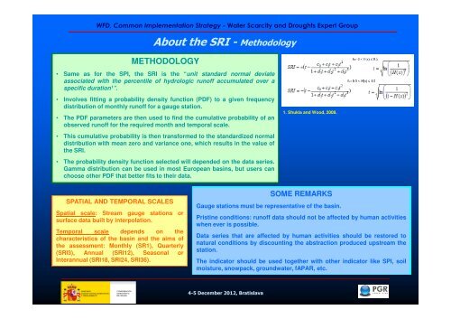
About the <strong>SRI</strong> - Methodology<br />
METHODOLOGY<br />
• Same as for the SPI, the <strong>SRI</strong> is the “unit standard normal deviate<br />
associated with the percentile of hydrologic runoff accumulated over a<br />
specific duration 1 ”.<br />
• Involves fitting a probability density function (PDF) to a given frequency<br />
distribution of monthly runoff for a gauge station.<br />
• The PDF parameters are then used to find the cumulative probability of an<br />
observed runoff for the required month and temporal scale.<br />
• This cumulative probability is then transformed to the standardized normal<br />
distribution with mean zero and variance one, which results in the value of<br />
the <strong>SRI</strong>.<br />
• The probability density function selected will depended on the data series.<br />
Gamma distribution can be used in most European basins, but users can<br />
choose other PDF that better fits to their data.<br />
1. Shukla and Wood, 2008.<br />
SPATIAL AND TEMPORAL SCALES<br />
Spatial scale: Stream gauge stations or<br />
surface data built by interpolation.<br />
Temporal scale depends on the<br />
characteristics of the basin and the aims of<br />
the assessment: Monthly (SR1), Quarterly<br />
(<strong>SRI</strong>3), Annual (<strong>SRI</strong>12), Seasonal or<br />
Interannual (<strong>SRI</strong>18, <strong>SRI</strong>24, <strong>SRI</strong>36).<br />
SOME REMARKS<br />
Gauge stations must be representative of the basin.<br />
Pristine conditions: runoff data should not be affected by human activities<br />
when ever is possible.<br />
Data series that are affected by human activities should be restored to<br />
natural conditions by discounting the abstraction produced upstream the<br />
station.<br />
The indicator should be used together with other indicator like SPI, soil<br />
moisture, snowpack, groundwater, fAPAR, etc.<br />
4-5 December 2012, Bratislava