Remote Sensing
Remote Sensing
Remote Sensing

Create successful ePaper yourself
Turn your PDF publications into a flip-book with our unique Google optimized e-Paper software.
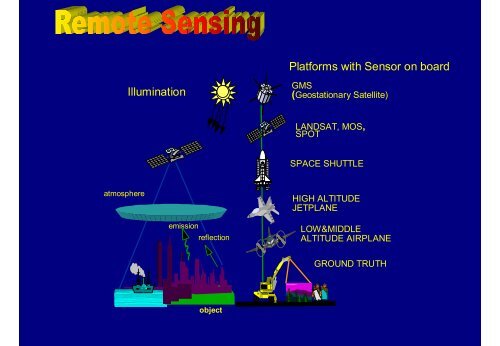
Platforms with Sensor on board<br />
Illumination<br />
GMS<br />
(Geostationary Satellite)<br />
LANDSAT, MOS,<br />
SPOT<br />
SPACE SHUTTLE<br />
atmosphere<br />
HIGH ALTITUDE<br />
JETPLANE<br />
emission<br />
reflection<br />
LOW&MIDDLE<br />
ALTITUDE AIRPLANE<br />
GROUND TRUTH<br />
object<br />
<strong>Remote</strong> <strong>Sensing</strong> - Introduction
Contents - Introduction to RS<br />
• Principles of <strong>Remote</strong> <strong>Sensing</strong><br />
– electromagnetic radiation<br />
– atmospheric interaction<br />
– surface reflection<br />
• <strong>Remote</strong> <strong>Sensing</strong> systems<br />
– Platforms<br />
– Sensors<br />
– Resolution: spatial, spectral, temporal<br />
• Applications of <strong>Remote</strong> <strong>Sensing</strong><br />
<strong>Remote</strong> <strong>Sensing</strong> - Introduction
Definition of <strong>Remote</strong> <strong>Sensing</strong><br />
<strong>Remote</strong> <strong>Sensing</strong> is a method to acquire<br />
information about material objects, areas, or<br />
phenomenon through the analysis of data<br />
acquired by a device from measurements made<br />
at a distance, without coming into physical<br />
contact with the objects, areas, or phenomena<br />
under investigation.<br />
<strong>Remote</strong> <strong>Sensing</strong> - Introduction
Why <strong>Remote</strong> <strong>Sensing</strong><br />
<strong>Remote</strong> <strong>Sensing</strong> - Introduction
Why <strong>Remote</strong> <strong>Sensing</strong><br />
<strong>Remote</strong> <strong>Sensing</strong> - Introduction
Why <strong>Remote</strong> <strong>Sensing</strong><br />
• To recognize macro-patterns which may not<br />
be visible from ground<br />
• To gain an OVERVIEW of an area<br />
• To gather information on large areas in short<br />
time<br />
• To gather information cost-effectively<br />
• To gather information on inaccessible places<br />
• To replace conventional sources of<br />
information (topo sheets, census data etc.)<br />
<strong>Remote</strong> <strong>Sensing</strong> - Introduction
What is <strong>Remote</strong> <strong>Sensing</strong><br />
We acquire much information about our surrounding through the<br />
senses of sight and hearing which do not require close contact<br />
between the sensing organs and the external objects. In another word,<br />
we are performing <strong>Remote</strong> <strong>Sensing</strong> all the time.<br />
Generally, <strong>Remote</strong> sensing refers to the<br />
activities of recording/ observing/<br />
perceiving (sensing) objects or events at<br />
far away (remote) places.<br />
<strong>Remote</strong> <strong>Sensing</strong> - Introduction<br />
Earth from Space
How does <strong>Remote</strong> <strong>Sensing</strong> Work<br />
Electro-magnetic radiation which is reflected or emitted from an object<br />
is the usual source of remote sensing data. A device to detect the<br />
electro-magnetic radiation reflected or emitted from an object is called a<br />
"remote sensor" or "sensor". Cameras or scanners are examples of<br />
remote sensors. A vehicle to carry the sensor is called a "platform".<br />
Aircraft or satellites are used as platforms.<br />
The characteristics of an object<br />
can be determined, using<br />
reflected or emitted electromagnetic<br />
radiation, from the<br />
object. Each object has a unique<br />
and different characteristics of<br />
reflection or emission if the type<br />
of object or the environmental<br />
condition is different. .<br />
<strong>Remote</strong> <strong>Sensing</strong> - Introduction
Principles of RS: EMR<br />
• The definition of RS implies the use of<br />
medium which carries the information from<br />
the object to the sensor<br />
• Usually, electro-magnetic radiation (EMR) is<br />
being used as medium<br />
• In passive RS, the radiation emitted by some<br />
other source is being used<br />
• In active RS, the radiation is being emitted by<br />
the system itself<br />
<strong>Remote</strong> <strong>Sensing</strong> - Introduction
Electro-Magnetic Radiation (EMR) / 2<br />
electric field<br />
magnetic field<br />
travelling direction<br />
λ (wave length)<br />
<strong>Remote</strong> <strong>Sensing</strong> - Introduction
The Electro-Magnetic Spectrum<br />
0.3 (cm) 1 3 10 30 100<br />
Microwave bands W V O Ka K Ku X C S L P<br />
Wavelength:<br />
Microwaves<br />
0.1nm 10nm 1µm 100µm 10mm 1m 100m 10km<br />
γ -ray X-ray UV Vis. Infrared EHF SHF UHF VHF MF LF VLF<br />
Radio waves<br />
Ultra Violet<br />
v<br />
I<br />
o<br />
l<br />
e<br />
t<br />
Visible Light<br />
b<br />
l<br />
u<br />
e<br />
g<br />
r<br />
e<br />
e<br />
n<br />
y<br />
e<br />
l<br />
l<br />
o<br />
w<br />
o<br />
r<br />
a<br />
n<br />
g<br />
e<br />
r<br />
e<br />
d<br />
Near Infra-red<br />
Short<br />
Wave<br />
Infra-red<br />
Intermediate<br />
Infra-red<br />
Thermal<br />
Infra-red<br />
wavelength (µm) 0.4 0.6 0.8 1 5 7 10<br />
<strong>Remote</strong> <strong>Sensing</strong> - Introduction
Characteristics of spectral regions<br />
Region Wavelength Remarks<br />
Gamma Ray 30 cm Longest wavelength portion of the electro-magnetic spectrum. Some<br />
classified radar with very long wavelength operate in this region.<br />
<strong>Remote</strong> <strong>Sensing</strong> - Introduction
• Makes use of sensors that detect the reflected or<br />
emitted electro-magnetic radiation from natural<br />
sources, most notably the sun.<br />
• Due to its surface temperature of 5800K, the sun<br />
emits most of its energy in the visible part of the<br />
spectrum.<br />
• The earth with a surface temperature of 300K emits<br />
most of its energy in the thermal part of the<br />
spectrum.<br />
<strong>Remote</strong> <strong>Sensing</strong> - Introduction
Spectral emission, atmospheric<br />
transmittance and sensor sensitivity<br />
Figure (3a)<br />
Energy Source<br />
Figure (3b)<br />
Atmospheric<br />
Transmittance<br />
Thermal Scanners<br />
Figure (3c)<br />
Common <strong>Remote</strong><br />
<strong>Sensing</strong> Systems<br />
<strong>Remote</strong> <strong>Sensing</strong> - Introduction
Atmospheric Transmittance<br />
<strong>Remote</strong> <strong>Sensing</strong> - Introduction
Interaction between EMR and surfaces<br />
<strong>Remote</strong> <strong>Sensing</strong> - Introduction
Spectral Reflectance Curves<br />
<strong>Remote</strong> <strong>Sensing</strong> - Introduction
Vegetation reflectance curves<br />
Chlorophyll<br />
absorption<br />
Water<br />
absorption<br />
<strong>Remote</strong> <strong>Sensing</strong> - Introduction
Mineral Reflectance curves<br />
<strong>Remote</strong> <strong>Sensing</strong> - Introduction
<strong>Remote</strong> <strong>Sensing</strong> Systems<br />
DATA ACQUISITION<br />
DATA ANALYSIS<br />
Reference<br />
data<br />
Pictorial<br />
Visual<br />
Numerical<br />
Quantitative<br />
Users<br />
Sources of<br />
energy<br />
Propagation<br />
through<br />
atmosphere<br />
Sensor systems Data products Interpretation<br />
procedures<br />
Re-transmission<br />
through atmosphere<br />
Information<br />
products<br />
Reflection on surface features<br />
<strong>Remote</strong> <strong>Sensing</strong> - Introduction
Platforms<br />
Platform Altitude Observation Remarks<br />
geostationary satellite 36,000km fixed point observation GMS<br />
circular orbit satellite<br />
(earth observation)<br />
500km -<br />
1,000km<br />
regular observation<br />
LANDSAT, SPOT,<br />
MOS, etc<br />
space shuttle 240km - 350km irregular observations<br />
radio - sound 100m - 100km various investigations<br />
(meteorological, etc)<br />
high altitude jet-plane 10km -12km reconnaissance, wide area<br />
investigations<br />
low or mid altitude plane 500m - 8,000m various aero investigation surveys<br />
helicopter 100m- 2,000m various aero investigation surveys<br />
radio-controlled plane below 500m various aero investigation surveys aeroplane,<br />
hang-plane 50 - 500m various aero investigation surveys hangglider<br />
hang-balloon 800m - various investigations<br />
cable 10 - 40m archaeological investigations<br />
crane car 5 - 50m close range surveys<br />
ground measurement<br />
car<br />
0 - 30m ground truth cherry picker<br />
<strong>Remote</strong> <strong>Sensing</strong> - Introduction
Earth Observation Satellite Orbits<br />
GROUND TRACK<br />
ALTITUDE = 705 KM<br />
(Nominal)<br />
INCLINATION = 98.2 O<br />
Equator crossing: 9:45am<br />
(Local time)<br />
DIRECTION OF TRAVEL<br />
ORBIT PERIOD = 98.9 MINUTES<br />
<strong>Remote</strong> <strong>Sensing</strong> - Introduction
Earth Observation Satellite Orbits / 2<br />
<strong>Remote</strong> <strong>Sensing</strong> - Introduction
Sensors<br />
A sensor or ‘remote sensor’ is a device<br />
to detect the electro-magnetic radiation<br />
reflected or emitted from an object.<br />
Cameras or scanners are examples of<br />
remote sensing-sensors.<br />
<strong>Remote</strong> <strong>Sensing</strong> - Introduction
Sensors: Solid State Scanners<br />
<strong>Remote</strong> <strong>Sensing</strong> - Introduction
Sensors: Opto-Mechanical Scanner<br />
<strong>Remote</strong> <strong>Sensing</strong> - Introduction
Characteristics of RS systems: Resolution<br />
In general, resolution is defined as the ability of an entire<br />
remote-sensing system, including lens, antennae,<br />
display, exposure, processing, and other factors, to<br />
render a sharply-defined image. Resolution of a remotesensing<br />
system is of different types.<br />
(1) Spectral Resolution<br />
(2) Radiometric Resolution<br />
(3) Spatial Resolution<br />
(4) Temporal Resolution<br />
<strong>Remote</strong> <strong>Sensing</strong> - Introduction
Spectral Resolution<br />
Detectors<br />
Incoming light<br />
(mix of different<br />
wavelengths)<br />
Prism or<br />
Spectrometer<br />
<strong>Remote</strong> <strong>Sensing</strong> - Introduction
Spectral Resolution / 2<br />
coarse spectral resolution: only 1 value,<br />
same for soil and turbid water<br />
finer spectral resolution: 3 values,<br />
each is different for soil / water<br />
<strong>Remote</strong> <strong>Sensing</strong> - Introduction
Spectral resolution of some RS systems<br />
0.40 0.50 0.60 0.70 0.80 0.90 1.00 1.10 2.10 3.10 4.20 6.20 8.20 10.20 12.20<br />
SPOT Pan SPOT XS Landsat TM<br />
NOAA AVHRR IRS LISS IRS WiFS<br />
ADEOS AVNIR<br />
<strong>Remote</strong> <strong>Sensing</strong> - Introduction
Spectral Band Range (µm) used in Thematic Mapper (TM) onboard<br />
Landsat's 4 and 5 sensor system and their potential application<br />
Band Band Range<br />
Number (µm)<br />
Potential applications<br />
1 0.45 to 0.52 coastal water mapping; soil/vegetation differentiation;<br />
deciduous/coniferous differentiation (sensitive to chlorophyll<br />
concentration); etc.<br />
2 0.52 to 0.62 green reflectance by healthy vegetation; etc.<br />
3 0.63 to 0.69 chlorophyll absorption for plant species differentiation;<br />
4 0.78 to 0.90 bio-mass surveys; water body delineation;<br />
5 1.55 to 1.75 vegetation moisture measurement; snow/cloud differentiation;<br />
6 10.4 to 12.5 plant heat stress management; other thermal mapping; soil moisture<br />
discrimination;<br />
7 2.08 to 2.35 hydrothermal mapping; discrimination of mineral and rock types;<br />
<strong>Remote</strong> <strong>Sensing</strong> - Introduction
Spectral Band Range (µm) used in Advance Very High Resolution Radiometer<br />
(AVHRR) sensor onboard NOAA Satellite system and their potential application.<br />
CHANNEL WAVE LENGTH) USES<br />
NUMBER<br />
(µm)<br />
CHANNEL 1 0.58 - 0.68 cloud delineation, weather snow and ice mapping and monitoring, etc.<br />
CHANNEL 2 0.73 - 1.1 surface water delineation, vegetation and agriculture assessment,<br />
range surveys, etc.<br />
CHANNEL 3 3.53- 3.93 land/water distinction, sea surface temperature, hot spot detection<br />
(forest fires and volcanic activity),etc.<br />
CHANNEL 4 10.3 - 11.3 day/night cloud mapping, sea and land surface temperature, soil<br />
moisture, volcanic eruption, etc.<br />
CHANNEL 5 11.5 12.5 sea surface temperature measurement, soil moisture, weather, etc.<br />
<strong>Remote</strong> <strong>Sensing</strong> - Introduction
Multispectral images: Landsat TM<br />
TM6 (10.4 -<br />
12.5)<br />
<strong>Remote</strong> <strong>Sensing</strong> - Introduction
<strong>Remote</strong> <strong>Sensing</strong> - Introduction
Spatial resolution / 2<br />
Landsat MSS (80m)<br />
SPOT XS (20m)<br />
IRS Pan (6m)<br />
KVR (2m)<br />
SPOT Pan (10m) Landsat TM (30m) IRS WiFS (188m) NOAA AVHRR (1.1km)<br />
<strong>Remote</strong> <strong>Sensing</strong> - Introduction
Spatial Resolution<br />
SATELLITE<br />
SYSTEM<br />
SOME<br />
OPTICAL SENSOR<br />
SYSTEM<br />
LANDSAT 4/5<br />
MSS<br />
LANDSAT 4/5<br />
TM<br />
SPOT<br />
XS<br />
NOAA<br />
AVHRR<br />
MOS<br />
MESSR<br />
JERS<br />
OPS<br />
VINR<br />
and<br />
SWIR<br />
ADEOS<br />
AVNIR<br />
IRS-1C<br />
LISS-III<br />
IRS-1C<br />
WiFS<br />
Spatial Resolution 80 m 30 m 20 m 1.1 km (LAC) 50 m 18 m X 24<br />
m<br />
Off-nadir viewing<br />
SPOT PAN<br />
JERS<br />
(side-look)<br />
(10m<br />
OPS<br />
capability for the<br />
resolution)<br />
VINR<br />
(PAN)<br />
0.51- 0.73 µm<br />
(18m X<br />
Panchromatic<br />
3 days revisit<br />
24m)<br />
mode for stereo<br />
capability<br />
Bands 3 &<br />
image data<br />
4<br />
acquisition)<br />
0.76 - 0.86<br />
µm<br />
16 m 24 m 188 m (200<br />
m)<br />
ADEOS IRS-1C PAN<br />
AVNIR (6 m<br />
PAN resolution)<br />
(8 m (70 km swath<br />
Resolution) width)<br />
0.52 - 0.50 - 0.70 µm<br />
0.72 µm (6-bit)<br />
<strong>Remote</strong> <strong>Sensing</strong> - Introduction
Spatial resolution: TM and SPOT Pan<br />
<strong>Remote</strong> <strong>Sensing</strong> - Introduction
Temporal resolution<br />
SATELLITE LANDSAT LANDSAT SPOT NOAA MOS JERS ADEOS IRS-1C IRS-1C<br />
SYSTEM MSS TM XS AVHRR MESSR OPS AVNIR LISS-III WiFS<br />
VINR<br />
AND<br />
SWIR<br />
Revisit Cycle 16 16 20 (nadir) 1 image/day 17 44 41 (nadir) 24 (nadir)<br />
(in days)<br />
<strong>Remote</strong> <strong>Sensing</strong> - Introduction
Quantization level of remote-sensing data<br />
Sensor Satellite Level (bit) Descriptions<br />
MSS LANDSAT 6 8 bits data after radiometric correction<br />
TM LANDSAT 8<br />
HRV (XS) SPOT 8<br />
HRV (PA) SPOT 6<br />
AVHRR NOAA 10 both 10 and 16 bits’ data are available at distribution<br />
SAR JERS-1 3 real 3 bits, imaginary 3 bits
<strong>Remote</strong> <strong>Sensing</strong> Satellite<br />
The remote sensing satellites are<br />
equipped with sensors looking down<br />
to the earth. They are the "eyes in the<br />
sky" constantly observing the earth as<br />
they move around the earth.<br />
<strong>Remote</strong> <strong>Sensing</strong> Satellite<br />
<strong>Remote</strong> <strong>Sensing</strong> satellite images gives a synoptic (bird’s eye) view of<br />
any places of the Earth surface, which helps to study, map, and<br />
monitor the Earth’s surface at local and/or regional/global scales. It is<br />
cost effective and gives better spatial coverage as compared to<br />
ground sampling.<br />
<strong>Remote</strong> <strong>Sensing</strong> - Introduction
Types of <strong>Remote</strong> <strong>Sensing</strong> Images<br />
There are several remote sensing satellite series in operation.<br />
Different satellite systems have different characteristics, e.g. resolutions,<br />
number of bands, and have their own importance for different<br />
application.<br />
Satellite Systems Spatial Resolution Type Number of Bands Launched by<br />
LANDSAT-ETM+<br />
LANDSAT-TM<br />
LANDSAT-MSS<br />
SPOT-XS<br />
SPOT-PAN<br />
IRS-1C PAN<br />
IRS-LISS-III<br />
IRS-WiFS<br />
Cosmos -KVR1000<br />
IKONOS<br />
IKONOS<br />
ADEOS-AVNIR M<br />
NOAA AVHRR<br />
MOS MESSR<br />
15,30,50<br />
30m<br />
80m<br />
20m<br />
10m<br />
6m<br />
24m<br />
188m<br />
2m<br />
1m<br />
4m<br />
16m<br />
1.1Km<br />
50m<br />
Multi-spectral<br />
Multi-spectral<br />
Multi-spectral<br />
Multi-spectral<br />
Panchromatic<br />
Panchromatic<br />
Multi-spectral<br />
Multi-spectral<br />
Panchromatic<br />
Panchromatic<br />
Multi-spectral<br />
Multi-spectral<br />
Multi-spectral<br />
Multi-spectral<br />
8<br />
7<br />
4<br />
3<br />
1<br />
1<br />
4<br />
2<br />
1<br />
1<br />
4<br />
4<br />
5<br />
4<br />
USA<br />
USA<br />
USA<br />
France, Sweden<br />
France, Sweden<br />
India<br />
India<br />
India<br />
Russia/USA<br />
Canada<br />
Canada<br />
Japan<br />
USA<br />
Japan<br />
<strong>Remote</strong> <strong>Sensing</strong> - Introduction
<strong>Remote</strong> <strong>Sensing</strong> - Introduction
SATELLITE LANDSAT LANDSAT4/5 SPOT NOAA MOS JERS ADEOS IRS-1C IRS-1C<br />
SYSTEM<br />
4/5<br />
TM<br />
XS AVHRR<br />
MESSR<br />
OPS AVNIR LISS-III WiFS<br />
SOME<br />
VINR<br />
MSS<br />
OPTICAL<br />
and<br />
SENSOR<br />
SWIR<br />
SYSTEM<br />
Spectral<br />
Resolution Four Seven Three Five Four Seven Four Four Two<br />
(Number of<br />
Bands)<br />
Spectral ranges (wave-length portion of EMR) in µm (micrometers)<br />
Blue 0.45 - 0.52 0.40 - 0.50<br />
Green 0.50 - 0.60 0.53 - 0.61 0.50 - 0.59 0.51 - 0.59 0.52 - 0.60 0.52 - 0.62 0.52 - 0.59<br />
Red 0.60 - 0.70 0.62 - 0.69 0.62 - 0.68 0.58 - 0.68 0.61 - 0.69 0.63 - 0.69 0.62 - 0.72 0.62 - 0.68 0.62 - 0.68<br />
NIR 0.70 - 0.80 0.78 - 0.90 0.78 - 0.88 0.73 - 1.10 0.72 - 0.82 0.76 - 0.86 0.77 - 0.86 0.77 - 0.86<br />
NIR 0.80 - 1.10 0.80 - 1.10 0.82 - 0.92<br />
IIR 1.57 - 1.78 1.60 - 1.71 1.55 - 1.75<br />
IIR 2.10 - 2.35 3.55 - 3.93 2.01 - 2.12<br />
IIR (MIR) 2.13 - 2.15<br />
IIR (MIR) 2.27 - 2.40<br />
ThIR 10.45 - 11.66 10.3 - 11.2<br />
FIR 11.5-12.5<br />
<strong>Remote</strong> <strong>Sensing</strong> - Introduction
<strong>Remote</strong> <strong>Sensing</strong> Images<br />
<strong>Remote</strong> sensing images are normally in the form of digital images.<br />
Image processing techniques are applied to enhance the image to help<br />
visual interpretation, information extraction and to correct or restore<br />
the image if the image has been subjected to geometric distortion, blurring<br />
or degradation by other factors. There are many image analysis techniques<br />
available and the methods used depending upon the requirements of the<br />
specific problem concerned.<br />
Satellite Image of Kathmandu<br />
<strong>Remote</strong> <strong>Sensing</strong> - Introduction