Uniform Mitigation Assessment Method TRAINING MANUAL
Uniform Mitigation Assessment Method TRAINING MANUAL
Uniform Mitigation Assessment Method TRAINING MANUAL

Create successful ePaper yourself
Turn your PDF publications into a flip-book with our unique Google optimized e-Paper software.
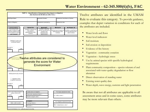
Water Environment - 62-345.500(6)(b), FAC<br />
Scoring Guidance<br />
The scoring of each<br />
indicator is based on what<br />
would be suitable for the<br />
type of wetland or surface<br />
water assessed<br />
w/o pres or<br />
current<br />
w/o pres or<br />
current<br />
w/o pres or<br />
current<br />
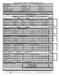
PART II – Quantification of <strong>Assessment</strong> Area (impact or mitigation)<br />
(See Sections 62-345.500 and .600, F.A.C.)<br />
Site/Project Name Application Number <strong>Assessment</strong> Area Name or Number<br />
Impact or <strong>Mitigation</strong><br />
.500(6)(a) Location and<br />
Landscape Support<br />
with<br />
.500(6)(b)Water Environment<br />
(n/a for uplands)<br />
with<br />
.500(6)(c)Community structure<br />
1. Vegetation and/or<br />
2. Benthic Community<br />
with<br />
Optimal (10)<br />
Condition is optimal and<br />
fully supports<br />
wetland/surface water<br />
functions<br />
<strong>Assessment</strong> conducted by:<br />
Moderate(7) Minimal (4)<br />
Condition is less than<br />
optimal, but sufficient to<br />
maintain most<br />
wetland/surface<br />
waterfunctions<br />
<strong>Assessment</strong> date:<br />
Minimal level of support of<br />
wetland/surface water<br />
functions<br />
Twelve attributes are considered to<br />
generate the score for Water<br />
Environment<br />
Not Present (0)<br />
Condition is insufficient to<br />
provide wetland/surface<br />
water functions<br />
Twelve attributes are identified in the UMAM<br />
Rule to evaluate this category. To provide guidance,<br />
examples that depict variation in conditions for each of<br />
the attributes are included.<br />
• Water levels and flows<br />
• Water level indicators<br />
• Soil moisture<br />
• Soil erosion or deposition<br />
• Evidence of fire history<br />
• Vegetation - community zonation<br />
• Vegetation – hydrologic stress<br />
• Use by animal species with specific hydrological<br />
requirements<br />
• Plant community composition – species tolerant of and<br />
associated with water quality degradation or flow<br />
alteration<br />
• Direct observation of standing water<br />
• Existing water quality data<br />
• Water depth, wave energy, currents and light penetration<br />
Score = sum of above scores/30 (if<br />
uplands, divide by 20)<br />
current<br />
or w/o pres<br />
Delta = [with-current]<br />
with<br />
If preservation as mitigation,<br />
Preservation adjustment factor =<br />
Adjusted mitigation delta =<br />
If mitigation<br />
Time lag (t-factor) =<br />
For impact assessment areas<br />
FL = delta x acres =<br />
For mitigation assessment areas<br />
Be aware that not all attributes are applicable to all<br />
assessment areas and in some cases, some attributes<br />
may be more relevant than others.<br />
Risk factor =<br />
RFG = delta/(t-factor x risk) =<br />
Form 62-345.900(2), F.A.C. [effective date 02-04-2004]