Sunrise Park Property Concept Plan - City of Tigard
Sunrise Park Property Concept Plan - City of Tigard
Sunrise Park Property Concept Plan - City of Tigard

You also want an ePaper? Increase the reach of your titles
YUMPU automatically turns print PDFs into web optimized ePapers that Google loves.
S<br />
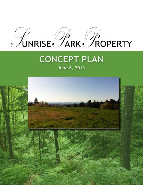
P P UNRISE ARK ROPERTY<br />
<strong>Concept</strong> PLAN<br />
June 6, 2013
Acknowledgements<br />
This document represents the collaborative<br />
process between the <strong>City</strong> <strong>of</strong> <strong>Tigard</strong> and community<br />
residents and organizations. This effort would not<br />
have been successful without the contributions<br />
from the following individuals who participated in<br />
public meetings and reviews, and who generously<br />
shared their time during the planning process.<br />
<strong>City</strong> <strong>of</strong> <strong>Tigard</strong><br />
<strong>Park</strong>s and Recreation Advisory Board<br />
David Brown<br />
Hong Dao<br />
Peggy Faber<br />
Gordon Kunkle<br />
Marshall Henry<br />
Troy Mears<br />
Holly Polivka<br />
Gary Romans (alternate)<br />
<strong>City</strong> <strong>of</strong> <strong>Tigard</strong> Public Works<br />
Steve Martin, <strong>Park</strong>s and Facilities Manager<br />
Conservation Technix, Inc.<br />
Steve Duh, CPRP, <strong>Park</strong>s Bond Program Manager<br />
Otak Inc., <strong>Concept</strong> <strong>Plan</strong> Consultant<br />
David Haynes, Project Manager<br />
Jennifer Mannhard, AICP, Land Use <strong>Plan</strong>ner<br />
Maggie Daly, Project <strong>Plan</strong>ner<br />
<strong>Tigard</strong> Community<br />
Friends <strong>of</strong> Bull Mountain<br />
Southside Soccer Club<br />
<strong>Tigard</strong> Lacrosse Club<br />
<strong>Tigard</strong> Little League<br />
Tualatin River Keepers<br />
Washington County<br />
Area Residents<br />
ii<br />
<strong>Sunrise</strong> <strong>Park</strong> <strong>Property</strong> | <strong>Concept</strong> PLAN | June 6, 2013
Table <strong>of</strong> Contents<br />
Executive Summary<br />
Background<br />
Site Analysis<br />
<strong>Plan</strong>ning Process<br />
<strong>Concept</strong> <strong>Plan</strong><br />
Implementation<br />
Appendix Title Page<br />
1<br />
3<br />
4<br />
6<br />
8<br />
11<br />
13<br />
<strong>Sunrise</strong> <strong>Park</strong> <strong>Property</strong> | <strong>Concept</strong> PLAN | June 6, 2013<br />
iii
iv<br />
<strong>Sunrise</strong> <strong>Park</strong> <strong>Property</strong> | <strong>Concept</strong> PLAN | June 6, 2013
Executive Summary<br />
The <strong>Sunrise</strong> <strong>Property</strong> is located on Bull Mountain<br />
at the northeast corner <strong>of</strong> SW 150th Avenue and<br />
<strong>Sunrise</strong> Lane. The <strong>City</strong> <strong>of</strong> <strong>Tigard</strong> purchased the<br />
19.43-acre site in May 2011 with funds from the<br />
<strong>Park</strong>s Bond Program.<br />
The <strong>Sunrise</strong> <strong>Park</strong> <strong>Property</strong> <strong>Concept</strong> <strong>Plan</strong> describes<br />
a potential layout for the park based on the needs<br />
and guidance in the <strong>City</strong> <strong>of</strong> <strong>Tigard</strong> <strong>Park</strong> System<br />
Master <strong>Plan</strong>, which includes program elements that<br />
should be considered for a community park. The<br />
concept plan tailors the program elements to the<br />
<strong>Sunrise</strong> <strong>Property</strong> to help guide planning and more<br />
detailed design in the future.<br />
The planning process included site analysis,<br />
stakeholder interviews, and two public open house<br />
meetings that provided a forum for community<br />
members and local park and trail advocates<br />
to voice ideas and concerns related to park<br />
development. The site analysis process identified<br />
three dominant traits <strong>of</strong> the site: open meadow<br />
surrounded by dense forest, steep slopes, and<br />
spectacular views to the north and west.<br />
Through the design process and public outreach,<br />
it was determined that the site was best suited to<br />
small group activity and passive recreation, with<br />
only limited organized sport play. The concept<br />
plan includes a soccer field, t-ball field, tennis<br />
court, basketball court, playground, picnic<br />
shelter, hard and s<strong>of</strong>t surface loop trails, and<br />
parking. Since the site becomes increasingly<br />
steep to the north, all <strong>of</strong> the amenities requiring<br />
large, level areas were consolidated within the<br />
flatter terrain to the south, near <strong>Sunrise</strong> Lane.<br />
The sloped character <strong>of</strong> the site created good<br />
opportunity for locating viewpoints with benches<br />
where visitors can rest and enjoy the scenic<br />
vistas. The concept plan also identifies potential<br />
access connections to the existing Cach property<br />
to the west and to the future Westside Regional<br />
Trail to the east.<br />
The approval by the <strong>Park</strong>s and Recreation<br />
Advisory Board <strong>of</strong> the concept plan will formalize<br />
the <strong>City</strong>’s commitment to this park development<br />
project. At such time in the future when<br />
this property is developed, detailed design<br />
and planning will need to address street and<br />
access improvements, sustainable design, and<br />
further community input. The preliminary cost<br />
estimate for the concept totals $3.8 million in<br />
development costs, $2.25 million (59%) <strong>of</strong> which<br />
are for street and access improvements needed<br />
for the park.<br />
<strong>Concept</strong> <strong>Plan</strong><br />
See page 9 for larger image.<br />
<strong>Sunrise</strong> <strong>Park</strong> <strong>Property</strong> | <strong>Concept</strong> PLAN | June 6, 2013 1
Vicinity Map<br />
2<br />
<strong>Sunrise</strong> <strong>Park</strong> <strong>Property</strong> | <strong>Concept</strong> PLAN | June 6, 2013
Background<br />
Project Purpose<br />
The <strong>City</strong> <strong>of</strong> <strong>Tigard</strong> purchased the 19.43-acre<br />
<strong>Sunrise</strong> <strong>Property</strong> in May 2011 with funds from<br />
the <strong>Park</strong> Bond that was approved by the voters<br />
in 2010. A park site concept plan was created<br />
for the property, as requested by the <strong>Park</strong> and<br />
Recreation Advisory Board for each property<br />
acquired through the use <strong>of</strong> the bond funds,<br />
to define and facilitate future development <strong>of</strong><br />
the site. The intent is to develop the <strong>Sunrise</strong><br />
<strong>Property</strong> as a community park to meet the<br />
need identified in the <strong>Park</strong> System <strong>Plan</strong>. The<br />
concept plan was prepared to explore the site<br />
opportunities, refine the recreation program<br />
called for in the <strong>Park</strong> System <strong>Plan</strong>, and address<br />
pedestrian linkages to the adjacent Cach Natural<br />
Area property.<br />
Project Study Area<br />
The property is located on Bull Mountain at the<br />
northeast corner <strong>of</strong> SW 150th Avenue and <strong>Sunrise</strong><br />
Lane with approximately 1,100 linear feet <strong>of</strong><br />
frontage on <strong>Sunrise</strong> Lane along the south and<br />
western edges. The northern and eastern edges<br />
<strong>of</strong> the property contain a mixed forest and steep<br />
slopes. The site was previously owned by DR<br />
Horton and platted for a subdivision, and several<br />
buildings and trees had been cleared from the<br />
site prior to purchase by the <strong>City</strong>.<br />
The <strong>Sunrise</strong> <strong>Property</strong> - Two Distinct Landscapes<br />
Background<br />
The <strong>City</strong> adopted its <strong>Park</strong> System Master <strong>Plan</strong> in<br />
2009. The plan outlines the need to acquire park<br />
property and construct park improvements to<br />
preserve open spaces, enhance water quality, and<br />
provide recreational opportunities. On November<br />
2, 2010, <strong>Tigard</strong> voters passed a $17 million<br />
general obligation bond to fund the purchase<br />
<strong>of</strong> real property for parks and to fund a limited<br />
amount <strong>of</strong> park improvements. The <strong>Sunrise</strong><br />
<strong>Property</strong> meets the classification <strong>of</strong> the proposed<br />
community park for site acquisition, master<br />
planning, and sport fields specifically identified in<br />
the <strong>Park</strong>s System <strong>Plan</strong> recommendations.<br />
The <strong>City</strong> <strong>of</strong> <strong>Tigard</strong> manages the nearby Cach<br />
Natural Area, which is located immediately west<br />
<strong>of</strong> the <strong>Sunrise</strong> property. The site is made up <strong>of</strong><br />
two pieces <strong>of</strong> undeveloped parkland (Cach and<br />
Clute properties) with an 11-acre reservoir site<br />
in between. Certain limitations exist for the<br />
development <strong>of</strong> the Cach property, since the<br />
site was purchased with Metro Greenspaces<br />
bond funds. Additionally, the water utility<br />
envisions the need for another reservoir nearby<br />
to accommodate continued growth in the Bull<br />
Mountain area.<br />
The cleared area on the south side <strong>of</strong> the property with steep<br />
slopes dropping <strong>of</strong>f to the north affords dynamic views in that<br />
direction.<br />
In contrast, the northern portion <strong>of</strong> the site is steeply sloped<br />
and heavily wooded.<br />
<strong>Sunrise</strong> <strong>Park</strong> <strong>Property</strong> | <strong>Concept</strong> PLAN | June 6, 2013 3
Site Analysis<br />
An analysis <strong>of</strong> the site was conducted to determine<br />
the opportunities afforded and constraints<br />
imposed by existing site conditions. A primary goal<br />
<strong>of</strong> the site analysis was to identify potential access<br />
connections, and to explore ways to effectively<br />
integrate the site into regional objectives for park<br />
amenities and trail networks.<br />
Land Use<br />
The <strong>Sunrise</strong> <strong>Property</strong> is nestled in a residential<br />
area <strong>of</strong> single-family homes and heavily wooded<br />
areas. It is zoned R-7, in which “Community<br />
Recreation” is permitted as a conditional<br />
use according the <strong>Tigard</strong> Development Code.<br />
Properties east and west <strong>of</strong> the site are also zoned<br />
R-7, and properties north and south <strong>of</strong> the site are<br />
in unincorporated Washington County.<br />
Slope Analysis<br />
The site has a steep elevation change falling<br />
approximately 200 feet from south to north.<br />
Elevations range from a high point <strong>of</strong> 630 feet<br />
along the east/west portion <strong>of</strong> <strong>Sunrise</strong> Lane<br />
to a low <strong>of</strong> 430 feet in the wooded area to the<br />
north. Areas <strong>of</strong> steep slopes (>25%) exist along<br />
the northern and eastern property edges. The<br />
southern third <strong>of</strong> the site has rolling topography,<br />
with vistas to the north and northwest.<br />
Resource Assessment<br />
A wetland determination and delineation<br />
conducted by Schott & Associates for DR Horton,<br />
Inc. shows a 0.05-acre (2,005 sf) sloped wetland<br />
exists near the property’s northwest corner. It lies<br />
within a depression flanked by steep slopes in a<br />
heavily wooded area.<br />
connections to these valuable recreational assets<br />
will firmly integrate the <strong>Sunrise</strong> property into<br />
the <strong>City</strong>’s parks and trail system. Connections to<br />
the Cach area and Westside trail will open access<br />
to the expansive residential neighborhoods that<br />
surround the site in all directions.<br />
Streets<br />
<strong>Sunrise</strong> Lane is classified as a Local Street with<br />
a standard right-<strong>of</strong>-way width <strong>of</strong> 46 feet and<br />
a paved width <strong>of</strong> 24 feet. SW 150th Avenue<br />
is classified as a Neighborhood Street with a<br />
standard right-<strong>of</strong>-way width <strong>of</strong> 50 to 58 feet<br />
and a paved width <strong>of</strong> 28 to 36 feet. Currently,<br />
however, no sidewalk or planter strip exists along<br />
these streets and the width <strong>of</strong> street pavement<br />
currently ranges from approximately 12 to 18<br />
feet.<br />
Utilities<br />
Access to water and electrical service are<br />
available near the site along <strong>Sunrise</strong> Lane, but<br />
sanitary and stormwater systems are not present<br />
on <strong>Sunrise</strong> Lane.<br />
Site Character<br />
The steep slopes on site will impact earthwork<br />
and views to and from the site. The varied<br />
vegetation <strong>of</strong>fers opportunities for different<br />
experiences and levels <strong>of</strong> comfort. The sun<br />
orientation will influence plant selection and<br />
placement. Prevailing winds will help determine<br />
locations for shelters and seating. Specific design<br />
decisions in response to these site characteristics<br />
are discussed in the <strong>Concept</strong> <strong>Plan</strong> section.<br />
Access and Circulation<br />
SW 150th Avenue provides the only vehicular<br />
access to the site. SW 147th Terrace dead ends at<br />
<strong>Sunrise</strong> Lane. Barricades at this location prevent<br />
vehicular access, but allow pedestrian connections<br />
to <strong>Sunrise</strong> Lane, the site, and an existing trail to<br />
Mistletoe Drive.<br />
The existing Cach Natural Area is immediately<br />
west <strong>of</strong> the <strong>Sunrise</strong> property, and the Westside<br />
Regional Trail corridor is a short stroll to the<br />
east via the existing Mistletoe Drive trail. Path<br />
Pedestrian access at 147th Terrace.<br />
4<br />
<strong>Sunrise</strong> <strong>Park</strong> <strong>Property</strong> | <strong>Concept</strong> PLAN | June 6, 2013
Site Analysis<br />
<strong>Sunrise</strong> <strong>Park</strong> <strong>Property</strong> | <strong>Concept</strong> PLan | June 6, 2013 5
<strong>Plan</strong>ning Process & <strong>Concept</strong> Development<br />
The <strong>Sunrise</strong> <strong>Park</strong> <strong>Property</strong> <strong>Concept</strong> <strong>Plan</strong> was<br />
developed through discussions with project<br />
stakeholders and <strong>City</strong> <strong>of</strong> <strong>Tigard</strong> staff and by<br />
engaging the community in conceptual plan<br />
review.<br />
To begin the concept plan process, the project<br />
team conducted phone interviews with key<br />
organizations to gain a better understanding <strong>of</strong><br />
project stakeholders’ objectives and concerns.<br />
These interviews set the stage for an efficient<br />
design process and for meaningful public<br />
involvement throughout the project. Specific<br />
organizations were selected in consultation with<br />
the <strong>City</strong>, and represent the broad recreational<br />
and environmental interests in <strong>Tigard</strong> and<br />
surrounding area.<br />
The key findings, concerns, and recommendations<br />
from these interviews were as follows:<br />
• While new park facilities <strong>of</strong> any kind are<br />
desired, there is a keen interest from<br />
recreation and sports groups for allweather<br />
facilities, specifically turf fields<br />
and covered basketball courts, in order to<br />
maximize usage <strong>of</strong> the park year round.<br />
• There is support for multi-function spaces<br />
to serve as many interests as possible;<br />
however, consideration should be given to<br />
layout and function <strong>of</strong> fields for efficient<br />
and shared use by different groups.<br />
• Proper field maintenance is a major<br />
concern for sports clubs. Many <strong>of</strong> them pay<br />
to maintain fields for their use in order to<br />
reduce risk <strong>of</strong> injury.<br />
• <strong>Park</strong>ing is essential to serve the sports<br />
uses <strong>of</strong> the park, but attention needs to be<br />
paid to potential pedestrian and bicycle<br />
connections as well.<br />
• Formalized trails through the lower,<br />
forested area are needed to minimize<br />
erosion from informal trails.<br />
• The <strong>City</strong> should reach out directly to the<br />
home owners on <strong>Sunrise</strong> Lane to discuss<br />
their perspectives related to trails, lights,<br />
parking, and privacy.<br />
• <strong>Tigard</strong> Little League feels the youngest ball<br />
players and s<strong>of</strong>tball players are the most<br />
underserved in terms <strong>of</strong> field space.<br />
Open House #1<br />
The project team held two public open houses<br />
to build upon these findings and provide an<br />
opportunity for the broader community to voice<br />
ideas and concerns pertaining to potential park<br />
development. The first open house was held on<br />
February 27, 2013 and focused on the history<br />
<strong>of</strong> the site and how opportunities identified for<br />
the property fit within the broader context <strong>of</strong><br />
the <strong>City</strong>’s Comprehensive <strong>Plan</strong> and <strong>Park</strong>s System<br />
<strong>Plan</strong>. The project team presented program layout<br />
alternatives that showed how the proposed park<br />
elements might be arranged on the site.<br />
The participants supported a park on this<br />
property as opposed to previous owners’ plans<br />
for a residential subdivision. They were pleased<br />
with the mix <strong>of</strong> active recreation elements<br />
and the natural, more undeveloped areas.<br />
Participants identified the walking trails and<br />
family-friendly feel <strong>of</strong> the park as some <strong>of</strong> the<br />
most positive aspects <strong>of</strong> the designs. They also<br />
expressed concerns over the traffic and parking<br />
that would be generated by the park. The<br />
comments included safety concerns about the<br />
narrow width <strong>of</strong> the area streets, the singular<br />
vehicular access point, and the limited sight lines<br />
at the intersection <strong>of</strong> Bull Mountain and SW 150th<br />
Avenue. Additional park amenities requested for<br />
consideration included:<br />
• Covered/uncovered basketball courts<br />
• Well-designed shelters and playground<br />
• Tennis courts<br />
• Dog park<br />
• Community room<br />
• More walking paths<br />
• Bike paths/cycle-cross<br />
• Amphitheater<br />
The project team described the site and design possibilities and<br />
listened to ideas and concerns about future park development.<br />
6<br />
<strong>Sunrise</strong> <strong>Park</strong> <strong>Property</strong> | <strong>Concept</strong> PLAN | June 6, 2013
Program Layout Alternatives<br />
The project team presented alternatives for how the recreation and related program<br />
elements might be arranged on the site.<br />
Open House #2<br />
The project team worked with the <strong>City</strong> <strong>of</strong> <strong>Tigard</strong><br />
to incorporate the community feedback received<br />
and develop a concept plan for the property.<br />
The second open house, held on April 24, 2013,<br />
provided the community an opportunity to<br />
view and comment on the draft concept plan.<br />
Participants expressed general support <strong>of</strong> the<br />
concept plan and provided feedback and questions<br />
concerning future safety aspects such as parking<br />
control, site lighting, and hours <strong>of</strong> use. Residents<br />
expressed concerns regarding site access and street<br />
width. The project team responded that such issues<br />
would be resolved at the time <strong>of</strong> future detailed<br />
design and land use approvals.<br />
<strong>Sunrise</strong> <strong>Park</strong> <strong>Property</strong> | <strong>Concept</strong> PLAN | June 6, 2013 7
CONCEPT <strong>Plan</strong><br />
Design efforts were guided initially by goals<br />
established in the <strong>City</strong>’s <strong>Park</strong> System Master<br />
<strong>Plan</strong>, which identifies recreation needs based<br />
on demographics and forecasts <strong>of</strong> population<br />
growth. The findings <strong>of</strong> the Master <strong>Plan</strong> informed<br />
decisions about the kinds <strong>of</strong> recreational<br />
amenities that should be considered for the<br />
<strong>Sunrise</strong> <strong>Property</strong>. The two public open houses<br />
provided a forum for community members and<br />
local park and trail advocates to help tailor the<br />
concept plan goals to the <strong>Sunrise</strong> <strong>Property</strong>.<br />
An important goal noted early in the design<br />
process was to create convenient links to the<br />
existing Cach <strong>Property</strong> to the west and to<br />
the future Westside Regional Trail to the east<br />
(by way <strong>of</strong> the existing trail connection to<br />
Mistletoe Drive). The s<strong>of</strong>t surface trails and<br />
densely wooded slopes <strong>of</strong> the Cach property<br />
will complement the more active and open<br />
character <strong>of</strong> the proposed <strong>Sunrise</strong> <strong>Property</strong><br />
improvements. The close proximity <strong>of</strong> the site<br />
to the Westside Trail corridor will make the<br />
<strong>Sunrise</strong> <strong>Property</strong> a favored destination within the<br />
regional trail network. With development <strong>of</strong> the<br />
<strong>Sunrise</strong> <strong>Property</strong>, the Cach <strong>Property</strong> will likely<br />
see increased use. The <strong>Concept</strong> <strong>Plan</strong> includes a<br />
trailhead with 3 to 4 gravel surface parking stalls<br />
and a hammerhead turnaround for improved<br />
vehicular circulation at <strong>Sunrise</strong> Lane.<br />
The site analysis process identified three<br />
dominant traits <strong>of</strong> the site: open meadow<br />
surrounded by dense forest, steep slopes, and<br />
spectacular views to the north and west. These<br />
site characteristics, and the desire to keep<br />
anticipated construction costs manageable,<br />
influenced the layout <strong>of</strong> park amenities including<br />
a soccer field, t-ball field, tennis court,<br />
basketball court, playground, picnic shelter, and<br />
parking.<br />
Since the site becomes increasingly steep to the<br />
north, all amenities requiring large, level areas<br />
were consolidated within the flatter terrain<br />
to the south, near <strong>Sunrise</strong> Lane. To better fit<br />
the terrain, the sport fields, sport courts, and<br />
parking lots were set at different elevations<br />
and separated by transition slopes. The sloped<br />
character <strong>of</strong> the site created good opportunity<br />
for locating viewpoints with benches where<br />
visitors can rest and enjoy the scenic vistas. Both<br />
hard and s<strong>of</strong>t surface loop trails are shown that<br />
venture down slope to the north providing various<br />
levels <strong>of</strong> difficulty and quality <strong>of</strong> experience as<br />
they wind through the property.<br />
Consideration was given to appropriate activities,<br />
noise levels, age groups, hours <strong>of</strong> operation, and<br />
accommodations such as lighting, and how these<br />
concerns are balanced with meeting city-wide<br />
recreational needs. Through the conceptual<br />
design process, it was determined that the<br />
site was best suited to small group activity and<br />
passive recreation, and only limited organized<br />
sport play. Restroom, playground, and sport<br />
court elements are located close to parking<br />
for convenient access and ease <strong>of</strong> monitoring,<br />
and lighting is limited to a single fixture at<br />
the restroom for security. Optional activities<br />
identified as appropriate to the site and context<br />
include: disc golf (up to 5 holes), small skate<br />
features, community gardens, horseshoe pits,<br />
bocce ball, and lawn bowling.<br />
The <strong>Park</strong> will be well-connected to the regional trail system.<br />
T-ball and soccer fields will accommodate youth sports.<br />
8<br />
<strong>Sunrise</strong> <strong>Park</strong> <strong>Property</strong> | <strong>Concept</strong> PLAN | June 6, 2013
<strong>Sunrise</strong> <strong>Property</strong><br />
CACH <strong>Property</strong><br />
CONCEPT <strong>Plan</strong><br />
<strong>Sunrise</strong> <strong>Park</strong> <strong>Property</strong> | <strong>Concept</strong> PLAN | June 6, 2013 9
Current Right-<strong>of</strong>-Way Conditions<br />
Future Connections<br />
Safety issues due to speeds and limited sight distance<br />
at the intersection <strong>of</strong> Bull Mountain Road and SW 150th<br />
Avenue is <strong>of</strong> concern to the community.<br />
Improved connections from the <strong>Sunrise</strong> <strong>Property</strong> to the Cach<br />
Natural Area would link the two destinations. New trailhead<br />
parking could be located next to <strong>Sunrise</strong> Lane.<br />
SW 150th Avenue leading to the <strong>Sunrise</strong> <strong>Property</strong> would need<br />
to be upgraded to its classification as a Neighborhood Street,<br />
which would widen the paved surface for appropriate vehicle<br />
and bicycle travel and add sidewalks.<br />
The <strong>Sunrise</strong> <strong>Property</strong> could also improve connections to the<br />
planned extension <strong>of</strong> the West Side Trail by connecting to the<br />
current path to Mistletoe Drive.<br />
<strong>Sunrise</strong> Lane would also likely need to be upgraded to its<br />
classification as a Local Street to provide safe multi-modal<br />
access to the park.<br />
Consideration should be given in the future to creating more<br />
access to the park by continuing <strong>Sunrise</strong> Lane through to<br />
connect to Menlor Lane and Barrows Road.<br />
10<br />
<strong>Sunrise</strong> <strong>Park</strong> <strong>Property</strong> | <strong>Concept</strong> PLAN | June 6, 2013
Implementation<br />
The approval by the <strong>Park</strong>s and Recreation<br />
Advisory Board <strong>of</strong> the concept plan will formalize<br />
the <strong>City</strong>’s commitment to this park development<br />
project. In the future when this property<br />
is developed, the following permitting and<br />
infrastructure considerations will need to be<br />
addressed through detailed design and planning.<br />
This concept plan is meant to guide the future<br />
development and use <strong>of</strong> the property, and the<br />
future use may change with the needs <strong>of</strong> the <strong>City</strong><br />
and the local community.<br />
Land Use and Infrastructure<br />
The <strong>Sunrise</strong> <strong>Property</strong> is zoned R-7, in which<br />
“Community Recreation” is permitted as a<br />
conditional use according to Table 18.510.1 <strong>of</strong><br />
the <strong>Tigard</strong> Development Code. Properties east<br />
and west <strong>of</strong> the site are also zoned R-7, and<br />
properties north and south <strong>of</strong> the site are in<br />
unincorporated Washington County.<br />
Street, water, and sewer improvements will be<br />
designed in accordance with the <strong>City</strong>’s Public<br />
Improvement Design Standards and corresponding<br />
design details. Because sanitary systems are not<br />
adjacent to the site, a least cost review <strong>of</strong> sewer<br />
options will be required.<br />
Stormwater facilities and modifications to the<br />
vegetated corridors will need to meet Clean<br />
Water Services and <strong>City</strong> design standards. Also,<br />
this project will be permitted under the <strong>City</strong>’s<br />
land use codes and environmental permitting<br />
requirements.<br />
Street and access improvements will need to be<br />
made along SW 150th Avenue and <strong>Sunrise</strong> Lane.<br />
The <strong>Tigard</strong> Transportation System <strong>Plan</strong> does not<br />
identify specific improvements on these two<br />
streets, but at a minimum the park side <strong>of</strong> the<br />
street would likely need to be upgraded. 150th<br />
Avenue is classified as a Neighborhood Street,<br />
which has a standard right-<strong>of</strong>-way width <strong>of</strong><br />
50-58 feet, and <strong>Sunrise</strong> Lane is classified as a<br />
Local Street, which has a standard right-<strong>of</strong>-way<br />
width <strong>of</strong> 46 feet. A secondary vehicular access<br />
should be considered as well as potential safety<br />
improvements at Bull Mountain Road and SW<br />
150th Avenue. The TSP calls for bike lanes and<br />
sidewalks along Bull Mountain Road.<br />
Due to the growing demand for water near Bull<br />
Mountain, a water reservoir may be built on<br />
either the Cach property or the <strong>Sunrise</strong> property<br />
in the future. The preferred location has not<br />
been determined yet. Extensive studies will<br />
need to be completed to determine a suitable<br />
location, which will depend on the stability <strong>of</strong><br />
the ground, size <strong>of</strong> the reservoir, security <strong>of</strong> the<br />
tank, and the associated costs. Placement <strong>of</strong> the<br />
tank may require the park concept plan to be<br />
revisited in the future when the tank is designed<br />
as landscaping around the tank will be needed.<br />
Future tank design solutions may include partially<br />
buried or soil-covered options generally similar to<br />
the Forest <strong>Park</strong> Low Tank Reservoir project.<br />
Sustainability<br />
Sustainable design features should be<br />
incorporated into the final park design and<br />
development. Potential features to consider<br />
include native and drought tolerant plants,<br />
pervious paving, low flow water fixtures,<br />
photovoltaic energy sources for lights and<br />
fixtures, LED and compact fluorescent lighting,<br />
and materials that are easy to repair and<br />
maintain.<br />
<strong>Sunrise</strong> <strong>Park</strong> <strong>Property</strong> | <strong>Concept</strong> PLAN | June 6, 2013 11
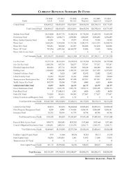
Cost Estimate<br />
A cost estimate was prepared for planning<br />
purposes and reflects current industry standards<br />
for unit costs based on recent projects as well<br />
as jurisdictions’ current permit fees. Following<br />
is a summary <strong>of</strong> the major categories, and the<br />
complete cost estimate is in the appendix <strong>of</strong> the<br />
report.<br />
Category<br />
Sub-total<br />
Mobilization $97,000<br />
Site Preparation & Earthwork $182,000<br />
Utilities & Stormwater $191,950<br />
Fields & Sports Courts $203,352<br />
Surfacing & Hardscaping $205,584<br />
Furnishing $145,300<br />
Fencing $18,360<br />
Landscaping & Irrigation $246,242<br />
Buildings & Structures $281,600<br />
Permit & Fees $18,426<br />
Total $1,589,814<br />
Access Improvements are calculated by<br />
multiplying the linear feet <strong>of</strong> improvement by<br />
$500 per linear foot. These access improvement<br />
and related PFI permit application fees are<br />
estimated as follows:<br />
Access Improvements<br />
Sub-total<br />
SW 150th to Bull Mountain Road $550,000.00<br />
<strong>Sunrise</strong> Lane <strong>Park</strong> Frontage $600,000.00<br />
<strong>Sunrise</strong> Lane to Menlor Lane $1,000,000.00<br />
PFI Permit Applications $107,500.00<br />
Total $2,257,500<br />
The park and access improvement estimates total<br />
$3,847,314.<br />
12<br />
<strong>Sunrise</strong> <strong>Park</strong> <strong>Property</strong> | <strong>Concept</strong> PLAN | June 6, 2013
Appendix<br />
Stakeholder Interviews Memorandum<br />
Open House #1 Summary<br />
Open House #2 Summary<br />
Open House Exhibits<br />
<strong>Concept</strong> <strong>Plan</strong> Cost Estimate<br />
A<br />
B<br />
C<br />
D<br />
E<br />
<strong>Sunrise</strong> <strong>Park</strong> <strong>Property</strong> | <strong>Concept</strong> PLAN | June 6, 2013 13
<strong>Sunrise</strong> <strong>Park</strong> <strong>Property</strong> | <strong>Concept</strong> PLAN | June 6, 2013
A. Stakeholder Interviews Memorandum<br />
<strong>Sunrise</strong> <strong>Park</strong> <strong>Property</strong> | <strong>Concept</strong> PLAN | June 6, 2013<br />
A
<strong>Sunrise</strong> <strong>Park</strong> <strong>Property</strong> | <strong>Concept</strong> PLAN | June 6, 2013
Memorandum<br />
To:<br />
Steve Duh, CPRP<br />
17355 SW Boones Ferry Rd.<br />
Lake Oswego, OR 97035<br />
Phone (503) 635-3618<br />
Fax (503) 635-5395<br />
From:<br />
Copies:<br />
Date: 01/29/2013<br />
Jennifer Mannhard, AICP<br />
David Haynes, RLA<br />
Subject:<br />
<strong>Sunrise</strong> Master <strong>Plan</strong> – Stakeholder Interviews<br />
Project No.: 16667<br />
The project team conducted phone interviews with key individuals to gain a better understanding <strong>of</strong><br />
project stakeholders’ objectives and concerns. These interviews set the stage for an efficient design<br />
process and for meaningful public involvement throughout the project. Specific organizations and<br />
individuals were selected in consultation with the <strong>City</strong>, and represent the broad recreational and<br />
environmental interests in <strong>Tigard</strong> and surrounding area. The interviews included:<br />
• Friends <strong>of</strong> Bull Mountain - Doug Vorwaller<br />
• Southside Soccer Club - Jason Cleaver, SSC Vice President & Treasurer<br />
• <strong>Tigard</strong> Lacrosse Club - Cort McCalister, TLC Treasurer<br />
• <strong>Tigard</strong> Little League - Vincent Ibarra, TLL Secretary & Treasurer<br />
• Tualatin River Keepers - Paul Whitney, Ph.D. Ecologist<br />
• Washington County – Paul Schaefer, Long Range <strong>Plan</strong>ning<br />
Key Findings, Concerns, and Recommendations<br />
• While new park facilities <strong>of</strong> any kind are desired, there is a keen interest from recreation and<br />
sports groups for all weather facilities, specifically turf fields and covered basketball courts,<br />
in order to maximize usage <strong>of</strong> the park year round.<br />
• There is support for multi-function spaces to serve as many interests as possible; however,<br />
consideration should be given to layout and function <strong>of</strong> fields for efficient and shared use by<br />
different groups.<br />
• Proper field maintenance is a major concern for sports clubs. Many <strong>of</strong> them pay to maintain<br />
fields for their use in order to reduce risk <strong>of</strong> injury.<br />
• <strong>Park</strong>ing is essential to serve the multi-function nature <strong>of</strong> the park, but focus needs to be paid<br />
to potential pedestrian and bicycle connections to and through the park. Trails through the<br />
lower land are needed to focus activity and minimize erosion.<br />
• The <strong>City</strong> should reach out directly to the home owners on <strong>Sunrise</strong> Lane to discuss their<br />
perspectives related to trails, lights, parking, and privacy.<br />
• <strong>Tigard</strong> Little League feels the youngest ball players and s<strong>of</strong>tball players are the most<br />
underserved in terms <strong>of</strong> field space.
Steve Duh Page 2<br />
<strong>Sunrise</strong> Master <strong>Plan</strong> – Stakeholder Interviews 01/29/2013<br />
Friends <strong>of</strong> Bull Mountain<br />
• Trail connectivity is important. Have a trail system through the park that connects to other<br />
trails in the area, specifically the proposed West Side Trail.<br />
• Tying into the Cache property is essential. <strong>Property</strong> ownerships along the east side <strong>of</strong> <strong>Sunrise</strong><br />
Lane may require an easement. There is an old road along the side <strong>of</strong> one <strong>of</strong> the properties.<br />
• S<strong>of</strong>t trails work well on top <strong>of</strong> utility rights-<strong>of</strong>-way, such as a sewer easement because the<br />
s<strong>of</strong>t trail maintains easy access to the utility.<br />
• Look at the bigger picture and connect trails to and through the property while maintaining<br />
some green space.<br />
• There is an existing paved trail that is not complete connecting <strong>Sunrise</strong> Lane to Mistletoe<br />
Drive. It was put in a number <strong>of</strong> years ago on a utility right-<strong>of</strong>-way.<br />
• There is an existing trail tie-in one house in on Ascension Drive that leads to the east.<br />
• Look at how a trail might be connected through on the north. There is no easy connection<br />
in that direction today.<br />
• Number one priority for trail connections should be to Mistletoe Drive and to the West-Side<br />
Trail. These two will open access for people to walk and bike to the park.<br />
• Investigate disc golf. It is a growing sport and would be <strong>of</strong> minimal cost to tie it into a trail<br />
to be built.<br />
• This park will be a destination park. It should accommodate people moving through it and<br />
using it as a trailhead if there is enough parking. There should be potential to expand parking<br />
in the future. Bike parking should be provided as well.
Steve Duh Page 3<br />
<strong>Sunrise</strong> Master <strong>Plan</strong> – Stakeholder Interviews 01/29/2013<br />
Southside Soccer Club<br />
• The city needs a turf field. Are there guidelines, restrictions, or other reasons the <strong>City</strong> seems<br />
resistant to turf Grass fields can be used only five to six months out <strong>of</strong> the year, whereas a<br />
turn field could be used year round.<br />
• If the <strong>City</strong> is going to spend money to develop the park and field(s), then we should get<br />
more use out <strong>of</strong> it.<br />
• Turf also eliminates some safety issues related to field maintenance and potholes in the<br />
fields.<br />
• Currently the Recreation program uses local elementary school fields for ages K through<br />
third or fourth grade, but fifth grade and older need bigger fields like Cook <strong>Park</strong>.<br />
• Programs fight for field space, particularly in March when baseball and lacrosse start up.<br />
• Any size field would be used. Even big kids practice in smaller areas.<br />
• A new field at the <strong>Sunrise</strong> property would be used for practices only as the Soccer Club pays<br />
a significant amount <strong>of</strong> money to use the <strong>Tigard</strong> High School turf field ($55,000 per year)<br />
and the Cook <strong>Park</strong> fields ($20,000).<br />
• Soccer is getting expensive due to these charges. <strong>Tigard</strong> should subsidize field use similar to<br />
other surrounding cities. For example, Lake Oswego charges a $10 per diem per child as<br />
opposed to the large amount <strong>Tigard</strong> charges for field rental.<br />
• <strong>Park</strong>ing should accommodate approximately 30 families if it is turf field that could<br />
accommodate games. A practice field needs only 10 to 15 spots somewhere close in the<br />
neighborhood.<br />
• Consider parking needs for other activities such as barbeques, receptions, and other<br />
celebrations.<br />
• Other than restrooms, amenities are not required and are not a priority.<br />
• For grass fields, put the goals on big rollers so they can be moved around easier for<br />
maintenance and mowing.<br />
• The most important and basic element is to make the fields level. Analyze how much the<br />
district spends on sand and seed versus what a turf field would cost. The turf itself is not the<br />
most expensive; it is the preparation and leveling work.<br />
• There is not a facility in the area to host a regional tournament. There isn’t a group <strong>of</strong> fields.<br />
They are scattered one or two all over and there is not a consolidated place with many fields<br />
to accommodate a tournament.<br />
• Citizens want to know when the development <strong>of</strong> the park might take place.<br />
<strong>Tigard</strong> Lacrosse Club<br />
• There is a need for more multi-use sports fields that would accommodate lacrosse, soccer,<br />
and football.<br />
• A turf field would be great. With the area’s climate, it can be raining well into May. Playing<br />
on the wet grass does much damage to the fields, particularly in March when it is really wet.<br />
The <strong>City</strong> doesn’t allow use <strong>of</strong> Cook <strong>Park</strong> fields in March for this reason.<br />
• Torn up fields creates a safety issue. Large holes can twist ankles and cause other injuries.<br />
• Lighted fields would be good and allow greater use <strong>of</strong> the facilities.
Steve Duh Page 4<br />
<strong>Sunrise</strong> Master <strong>Plan</strong> – Stakeholder Interviews 01/29/2013<br />
• Regulation size would also allow for greater usage opportunities. Smaller fields can be used<br />
for practice, but get eliminated from consideration for games.<br />
• The park should also have basketball courts. Covered, but not fully enclosed, courts would<br />
be great. Alberta Rider Elementary School is a great example. It has covered basketball<br />
courts that are really well used and allow for recreation in the rainy months.<br />
• Bathroom facilities are essential, but other amenities are low priority. Bleachers would be<br />
nice, but not essential and concessions are not needed. Playground facilities near the field(s)<br />
are great to keep younger children happy while the older kids practice or play games.<br />
• Convenient parking is needed to accommodate the field use. For a single game, there are 20<br />
kids on each team, so there will be 40 families trying to park.<br />
• Regular maintenance <strong>of</strong> fields is a huge issue. The <strong>Tigard</strong> Lacrosse Club uses membership<br />
money to help maintain the middle school fields. This year, <strong>Tigard</strong> Lacrosse Club and Youth<br />
Football each paid $3,500 to improve the fields. The Club utilizes one <strong>City</strong> ball field and<br />
several fields operated by TTSD.<br />
• Lacrosse fields in <strong>Tigard</strong> are embarrassing. Because <strong>Tigard</strong> Lacrosse Club plays games all<br />
over the region, they have the opportunity to use fields in other jurisdictions. Comparatively,<br />
all other local communities have much better maintained fields that do not have large divots.<br />
• Do not overlap the baseball field with the mixed-use field. When baseball players are hitting,<br />
it makes the multi-use field unusable.<br />
• There needs to be a fair distribution <strong>of</strong> types and locations <strong>of</strong> fields based on need.<br />
• Tualatin’s Ibach <strong>Park</strong> is a great example. (Shown below)
Steve Duh Page 5<br />
<strong>Sunrise</strong> Master <strong>Plan</strong> – Stakeholder Interviews 01/29/2013<br />
<strong>Tigard</strong> Little League<br />
• The <strong>Tigard</strong> Little League is currently experiencing a shortage <strong>of</strong> fields, particularly for the<br />
youngest players (Pee Wee) and s<strong>of</strong>tball players. They rent space from <strong>Tigard</strong> <strong>Park</strong>s and<br />
from local elementary, middle, and high schools for games.<br />
• Some <strong>of</strong> the school fields are older, not maintained as well, and could be safer. <strong>Tigard</strong> Little<br />
League has to prepare a yearly safety report to the national organization for its charter. Often<br />
they work with the Eagle Scouts and the schools to rectify safety issues, but funding is<br />
always an issue.<br />
• They have also played on Hanson Field behind the LDS church and on St. Anthony’s field.<br />
• The T-ball kids play on an open field at Summer Lake <strong>Park</strong>.<br />
• Growth in the League is expected to continue. And the League is supportive and will help in<br />
the development <strong>of</strong> more ball fields to the extent possible. They have been successful in<br />
getting sponsors and funds to help make development happen.<br />
• Their season is more limited than other sports playing April through July, but the partial use<br />
allows the fields to recuperate between seasons.<br />
• The older boys play at Cook <strong>Park</strong>. The relationship with the <strong>City</strong> <strong>of</strong> <strong>Tigard</strong> is good for that<br />
facility. The greatest need is for the youngest players and for s<strong>of</strong>tball.<br />
• Nicer fields can have movable bases to accommodate a variety <strong>of</strong> players.<br />
• Bleachers and dugouts would be nice, but the priority is on the fields themselves.<br />
• <strong>Park</strong>ing is essential. There are about 12 kids per team, so need approximately 20 spaces per<br />
game.<br />
• The Pee Wee games can be on open fields, on turf, and located closer to parking lots and<br />
streets because they are not hitting the ball with the same force as the older kids.<br />
Tualatin River Keepers<br />
• This property is a wonderful natural area, but does not have any specific attributes <strong>of</strong><br />
ecological value (i.e., no wetland, old growth trees, or rare plants).<br />
• There are trails <strong>of</strong> various conditions, including an old logging road and basic dirt trails,<br />
through the lower area. The trails need maintenance and attention.<br />
• Several places are eroding significantly and will get worse. Water bars need to be installed to<br />
prevent erosion. If a trail is mid-slope, it will catch rainwater. Installing water bars or logs<br />
across the trail can divert water into existing vegetation to minimize erosion. The trail along<br />
the main water way, specifically, really needs water bars.<br />
• Connect the upper and lower areas with formalized trails with switchbacks to help minimize<br />
erosion.<br />
• Add trails to help focus activity and keep people in specific locations.<br />
• There is a fence blocking the trail that ran along the creek in the lower area, presumably put<br />
up by the neighbor to keep people from taking the trail through their property. It is essential<br />
to talk to the neighbors and to work with them to screen their property from the trail.<br />
• Paul provided some anecdotal evidence <strong>of</strong> concerns by the neighbors. They are going to be<br />
protective <strong>of</strong> the area and may be concerned about trails adjacent or near their properties.<br />
• There are some logical connections to the Cache property that are basically straight shots<br />
through on gravel with no trees, but the neighbors obviously don’t want people cutting
Steve Duh Page 6<br />
<strong>Sunrise</strong> Master <strong>Plan</strong> – Stakeholder Interviews 01/29/2013<br />
through as there is a fence blocking the way. Come into this design process with strategies<br />
for screen and fencing to help neighbors feel better about a connection.<br />
• Between the lower and upper areas, there are isolated areas <strong>of</strong> conifer trees. A decision needs<br />
to be made as to adding vegetation around them to blend the trees into the forest area or to<br />
removing them.<br />
• Trails on the <strong>Sunrise</strong> and Cache properties need to be added to the regional master plan and<br />
be included in Metro’s intertwine concept sponsored by ODOT.<br />
• <strong>Tigard</strong> should wait to master plan parks until all the bond money has been used to purchase<br />
property in order to determine the most appropriate sites for natural areas and the more<br />
suitable for ball fields and courts.<br />
• The educational opportunities <strong>of</strong> these properties need to be optimized. There seems to be a<br />
feeling that the environmental community doesn’t want children in natural areas in order to<br />
protect the land, but this is not true. Trails and interpretive signs should be installed to<br />
educate people <strong>of</strong> all ages about the natural area.<br />
Long Range <strong>Plan</strong>ning, Washington County<br />
• There will likely be much public support for a new park in this area. They hear <strong>of</strong>ten about<br />
the lack <strong>of</strong> and need for more parks.<br />
• Access and connectivity will be important. This includes trails and sidewalks in addition to<br />
roads. Over time as property changes hands, the road improvements and access may become<br />
easier.
B. Open House #1 Summary<br />
<strong>Sunrise</strong> <strong>Park</strong> <strong>Property</strong> | <strong>Concept</strong> PLAN | June 6, 2013<br />
B
Memorandum<br />
Meeting: <strong>Sunrise</strong> <strong>Property</strong> Master <strong>Plan</strong> Open House #1<br />
17355 SW Boones Ferry Rd.<br />
Lake Oswego, OR 97035<br />
Phone (503) 635-3618<br />
Fax (503) 635-5395<br />
Project No.: 16667<br />
Meeting Date: February 27, 2013<br />
Meeting Time: 5:30 – 7:00 pm<br />
Location:<br />
Attendees:<br />
Notes By:<br />
Alberta Rider Middle School<br />
Steve Martin, <strong>City</strong> <strong>of</strong> <strong>Tigard</strong>; Steve Duh,<br />
Conservation Technix, Inc.; David Haynes, Jennifer<br />
Mannhard, Otak; community attendees<br />
David Haynes<br />
On Wednesday February 27, 2013 an open house was held at Alberta Rider Elementary School in<br />
<strong>Tigard</strong> from 5:00–7:30pm. The purpose <strong>of</strong> the open house was two-fold. The first was to inform<br />
participants about the history <strong>of</strong> the property, how opportunities identified for the property fit<br />
within the broader context <strong>of</strong> the <strong>City</strong>’s Comprehensive <strong>Plan</strong> on <strong>Park</strong>s, Recreation, Trails, and Open<br />
Space, and to show a few preliminary concepts exploring ways that the proposed park elements<br />
might be arranged on the site. Second was to encourage the community to <strong>of</strong>fer input on the<br />
preliminary concepts, and to provide an opportunity for participants to voice ideas and concerns<br />
pertaining to potential park development. Following is a summary <strong>of</strong> comments received.<br />
Comment Cards<br />
Question #1: What do you feel are the most positive aspects <strong>of</strong> the proposed design<br />
• <strong>Park</strong>ing<br />
• Walking trails, kids play structure<br />
• Improved space in general<br />
• Trails, shelters<br />
• Mostly natural, “undeveloped.”<br />
• Trails – family friendly<br />
• A[n] area for friends, family, safe, fun<br />
• The inclusion <strong>of</strong> at least one sports field for youth athletics<br />
• That it is a park and not 86 homes.
<strong>Sunrise</strong> <strong>Property</strong> Master <strong>Plan</strong> Page 2<br />
Open House #1 02/27/2013<br />
Question #2: Do you have concerns about any aspects <strong>of</strong> the proposed designs<br />
• Connect 150 th to street on North side.<br />
• Prefer walking features over organized sport fields.<br />
• <strong>Park</strong>ing, traffic<br />
• Car parking<br />
• Access/egress – 150 th & Bull Mtn. Road intersection is dangerous. <strong>Tigard</strong> knew the<br />
limitations <strong>of</strong> this property before acquiring it. The steep slope is unusable. Don’t try to<br />
force more development than the property can comfortably accommodate.<br />
• I feel money would be better spent turfing Tuality M.S., and 2 fields @Fowler M.S. than<br />
adding add’l grass fields.<br />
• 150 th only access is not good.<br />
• Small fields for tot or family play<br />
• Too much traffic<br />
• Wet rain – no baseball, no soccer!<br />
• The danger <strong>of</strong> the intersection <strong>of</strong> 150 th & Bull Mountain Road and the width <strong>of</strong> 150 th .<br />
• We live at 14905 SW <strong>Sunrise</strong> Lane and we are concerned about foul balls from the ball park<br />
that is proposed behind our house. Possibly ball hitting vehicles, house or hunting trailer on<br />
our property.<br />
Question #3: Please feel free to leave any other comments.<br />
• Must have access onto property from Grandview Ln., not just 150 th .<br />
• Need more access from north and more bathroom[s].<br />
• Dog parks and walking trails would be less invasive to the natural area.<br />
• Looking forward to using the space. Thanks!<br />
• Open the access into the Bull Mtn. Estates neighborhood to moderate traffic congestion.<br />
<strong>Sunrise</strong> Lane realignment should preserve the tree grove on the south side. As plans develop,<br />
more <strong>of</strong> these meetings will be needed.<br />
• I’d like to see the park amenities planned in conjunctions with EBMP, Cach, West Side Trail<br />
and the <strong>Sunrise</strong> annexation. Think about the full picture <strong>of</strong> what you are building for<br />
community park services & a linked trail system through the city.<br />
• Dog <strong>Park</strong><br />
• Basketball hoops lots around a slab like (Laurel Ridge School); diff. sizes some for the little<br />
guys<br />
• Make it a nature park. Put trees and native plants. The view from the park is very beautiful.
<strong>Sunrise</strong> <strong>Property</strong> Master <strong>Plan</strong> Page 3<br />
Open House #1 02/27/2013<br />
Comments on Poster Boards<br />
Access and <strong>Park</strong>ing<br />
• Access <strong>of</strong>f Grandview and 150 th to <strong>Sunrise</strong> Ln.<br />
• Complete <strong>Sunrise</strong> Lane connection to Barrows Rd.<br />
• Consider overflow/secondary parking under power line to east <strong>of</strong> site with path/trail to<br />
park.<br />
• Access along Bull Mtn @ 150 th is problem<br />
o Worst intersection – hazard – on rise<br />
o Fire and safety access<br />
• Road access – provide at least 2 points <strong>of</strong> entry<br />
• If fields remain and programmed, not enough parking provided<br />
Site Program and Amenities<br />
• Do more with site – expected more:<br />
o add tennis, full court basketball<br />
o Make it for full community – people park<br />
• Consider location for Community Room.<br />
• Can a dog park be accommodated<br />
• Basketball (look at Laurel Ridge in Sherwood)<br />
o Excellent community activity<br />
• Consider using the entire site as green space and walking park.<br />
• Sport court (basketball / tennis court)<br />
• Maximize enjoyment <strong>of</strong> view – signature <strong>of</strong> this park.<br />
• S<strong>of</strong>t trails<br />
• Dog <strong>Park</strong> (like L.O. <strong>of</strong>f Stafford Rd, Luscher Farm <strong>Park</strong>)<br />
• Consider dog park & playground instead <strong>of</strong> ball fields.<br />
• Hillside could accommodate amphitheater space<br />
• How was it decided to suggest ball fields on site<br />
o What guides site development options<br />
• Will fields be staked/fenced in wet season<br />
Materials and Quality<br />
• Use creativity/imagination/quality materials that are renewable and cost effective.<br />
• Consider tuft fields for extra play-ability.<br />
• As natural settings and amenities as possible<br />
• Well designed playgrounds and shelters (like Tualatin, Sherwood and L.O.)
<strong>Sunrise</strong> <strong>Property</strong> Master <strong>Plan</strong> Page 4<br />
Open House #1 02/27/2013<br />
Other<br />
• Ask sport leagues to stagger game schedule to minimize parking loads and transportation<br />
impacts.<br />
• Cycle cross as fund raiser – “build trails and they will come.”<br />
Comments Submitted by Nancy Younger<br />
Brief List <strong>of</strong> Ideas for <strong>Sunrise</strong> Lane <strong>Park</strong>: I have many ideas which I have developed as I have<br />
walked and hiked the mountain side and savored the fantastic view <strong>of</strong> our special park. I will make a<br />
list <strong>of</strong> several ideas and expand on them later.<br />
1. Mountainside <strong>Park</strong>. The park site is on the side <strong>of</strong> a mountain. It does not lend itself to<br />
large scale organized sports like soccer and baseball. (These types <strong>of</strong> sports specific areas<br />
need to be on Beef Bend Road, a main thoroughfare, where the terrain is flat and is easily<br />
accessed by large numbers <strong>of</strong> cars.) The mountainside park is especially suited for individual<br />
and small group activities like walking, trail hiking, biking, dog walking, enjoying the<br />
panoramic view and play.<br />
2. View points (plural) with mountain pointers. “What is that mountain over there What is<br />
that range Is that the Coast range” An in-ground view guide to our local hills and<br />
mountains would be educational, view enhancing and fun. There is a perfect view <strong>of</strong> Mt St<br />
Helens.<br />
3. Native American spot for “Morning Song” Native Americans greet the day with a morning<br />
song and prayer. The gorgeous pink morning skies in the east are spiritually renewing and a<br />
great way to start the day.<br />
4. Say Goodnight. Every evening at least in summer when the sun is out. The crows and other<br />
birds roost in the very tip tops <strong>of</strong> the trees to say goodnight to the sun and the day. The<br />
“Morning Song” spot could double as a spot to thoughtfully end the day. “The sun<br />
bowl”…I’ll explain later.<br />
5. <strong>Park</strong>our trail. How great. the sport <strong>of</strong> moving along a route, typically in a city, trying to get<br />
around or through various obstacles in the quickest and most efficient manner possible, as<br />
by jumping, climbing, or running: his amazing parkour skills<br />
6. Climbing wall.<br />
7. Amphitheatre. For small music presentations. Outdoor Cinema . A magician. Political<br />
speeches. Et al.<br />
8. Lawn is passe’ Expensive in tools, equipment, water and man hours. Environmentally on<br />
the outs.<br />
9. Timber buildings are in keeping with lodge atmosphere like those in NY.<br />
10. Benches to enjoy the view.<br />
11. The Orchard. Delicious Apples, Pears, Plums on the property. Trees which Master<br />
Gardeners can use to teach tree care.<br />
12. Tennis Court. OK if you must.<br />
13. Hiking trails to connect with wildlife area, West side trail, around the park.<br />
14. Fort or Cabin for kids to play in. They were playing war games the other day. We need<br />
holes, caves, hillocks and hiding places.<br />
15. Garden. A special design that would draw older adults who enjoy the rose garden type<br />
display. Wildflowers maybe. Some <strong>of</strong> each.
<strong>Sunrise</strong> <strong>Property</strong> Master <strong>Plan</strong> Page 5<br />
Open House #1 02/27/2013<br />
16. The Christmas Tree. There is a perfect Douglas Fir xmas tree that would be fun to decorate<br />
at Christmas. It could be seen for miles.<br />
17. Dog <strong>Park</strong>. Tons <strong>of</strong> people bring their dogs, via foot or car to run in the park.<br />
18. Picnics. Wagons in the parking area to carry picnic supplies throughout the park.<br />
19. Fire Pit for singing around. Storytelling. The library is having a special storytelling event.<br />
This park would be perfect for that.<br />
20. Fireworks. Well we go there on the 4 th to watch the fireworks around the county. Cool.<br />
Multi-shows.<br />
21. Community Building for classes, wedding, photography instruction.<br />
22. Sledding Hill. It is a natural sledding hill when it snows. I have my disc.<br />
23. Biking. Mountain biking trail would be so cool.<br />
24. Geocaching Welcome / Amenable Now a hughly popular sport/activity. My sister just<br />
help out with a meet in Yuma, AZ and 1000 geocachers attended.<br />
25. Frisbee Golf – No. My daughter and I visited Sunset <strong>Park</strong> in Las Vegas, NV. It was<br />
evidently a sports park because they had soccer and baseball fields as well as Frisbee Golf.<br />
Everywhere we sat in our three different visits to the park, we had to duck and cover to<br />
avoid Frisbees which don’t just fly straight toward the target. They curve and take a wide<br />
swath.<br />
26. Tai Chi – I would love to visit the park like they do in China and do Tai Chi in the morning<br />
with a group.<br />
27. Cultural Amenities – We have a large Asian population on Bull Mountain and a variety <strong>of</strong><br />
ethnicities in <strong>Tigard</strong>. Some activities and amenities could be designed for activities they<br />
particularly enjoy.<br />
28. BBQs – A big favorite at Cook <strong>Park</strong>. Family fun. Hamburger and a birthday party and a<br />
gorgeous sunset.<br />
29. Wildlife overlook. Enhance the pond in the gulch and provide an overlook with benches to<br />
view the wildlife below.<br />
30. Volks walks. A popular activity along with Orienteering where people enjoy trails with stops<br />
along the way and GPA points.<br />
31. Giant Checkers. Oh I loved this at Pennisula <strong>Park</strong>, now celebrating their 100 th anniversary.<br />
Maybe we could get some rose starts from their roses.<br />
32. Rolling down the hill. A meadow, grassy or ground cover hill where kids can roll down and<br />
laugh.<br />
33. Bird watching. We have a wide variety <strong>of</strong> birds. Would a bird blind aid in watching and<br />
photographing the birds Fun!<br />
34. Singing Tree. Not people but birds. Every morning the birds sing like crazy from particular<br />
trees. Identify these trees and limit pruning and enhance care so you don’t scare the birds<br />
away.<br />
35. A wild flower meadow would be an ideal spot for walking and weddings.<br />
36. Skate <strong>Park</strong>. The <strong>Tigard</strong> Skate <strong>Park</strong> looks tough. I have seen skateboarders on the street.<br />
Some have those long banana boards. A beginner skate park would be fantastic. A down<br />
hill run would be cool.
C. Open House #2 Summary<br />
<strong>Sunrise</strong> <strong>Park</strong> <strong>Property</strong> | <strong>Concept</strong> PLAN | June 6, 2013<br />
C
Meeting Notes<br />
Meeting: <strong>Sunrise</strong> <strong>Property</strong> Open House #2<br />
700 Washington Street<br />
Suite 401<br />
Vancouver, WA 98660<br />
Phone (360) 737-9613<br />
Fax (360) 737-9651<br />
Project No.: 16667<br />
Meeting Date: April 24, 2013<br />
Meeting Time:<br />
5:30 - 7:00 pm<br />
Location:<br />
Attendees:<br />
Notes By:<br />
Alberta Rider Middle School<br />
Steve Martin, <strong>City</strong> <strong>of</strong> <strong>Tigard</strong>; Steve Duh,<br />
Conservation Technix, Inc.; David Haynes, Maggie<br />
Daly, Otak; community attendees<br />
Maggie Daly<br />
Verbal comments and questions during Open House #2:<br />
• How many access points (road)<br />
o At least two – and preferably three – recommended.<br />
o Land use requirements will dictate the number and development <strong>of</strong> park access ways.<br />
• Will you buy additional right <strong>of</strong> way to expand the street<br />
o Additional right <strong>of</strong> way will be discussed as part <strong>of</strong> a future land use application review.<br />
• Will you provide a dog park<br />
o Consider looking at Area 63/64.<br />
• How might a future water tower affect the site design<br />
• Will lighting be installed<br />
o Ball field lighting is not proposed, and safety/security lighting may be installed.<br />
• <strong>Park</strong>ing – will both lots be closed after hours<br />
o Consider providing managed controls or gates for each parking lot.<br />
• What is enforcement <strong>of</strong> afterhours use<br />
• Post pathways with “stay on the trail” signs to keep walkers on path<br />
• Provide doggie bags/dispensers<br />
• Do a field mowing now – grass is tall.<br />
• What funding options are you considering<br />
o Timeline for development<br />
• Continue to clean up camps/garbage on Cach<br />
• Expand T-ball field to full size baseball field
D. Open House Exhibits<br />
<strong>Sunrise</strong> <strong>Park</strong> <strong>Property</strong> | <strong>Concept</strong> PLAN | June 6, 2013<br />
D
LEGEND:<br />
WASHINGTON<br />
COUNTY<br />
TIGARD<br />
UNINCORPORATED<br />
WASHINGTON<br />
COUNTY<br />
13125 SW HALL BLVD.<br />
TIGARD, OR 97223<br />
Phone: 503.639.4171<br />
ZONE R-6<br />
TIGARD<br />
14905 SW<br />
SUNRISE LANE<br />
WASH CO.<br />
S.W. SUNRISE LANE<br />
WASH CO.<br />
ZONE R-6<br />
WETLAND,<br />
.05 ACRES<br />
(DELINEATED<br />
BY SCHOTT &<br />
ASSOCIATES)<br />
15169<br />
SUNRISE LANE<br />
15156 SW<br />
SUNRISE LANE<br />
15155 SW<br />
SUNRISE LANE<br />
TIGARD<br />
SW SUNRISE LANE<br />
15065 SW<br />
SUNRISE LANE<br />
WASH CO.<br />
ZONE R-6<br />
SW 150TH AVE.<br />
BID SET - MAY 18, 2012<br />
EXISTING TRAIL TO<br />
CACH PROPERTY<br />
WASH CO.
TO HWY 99<br />
13125 SW HALL BLVD.<br />
TIGARD, OR 97223<br />
Phone: 503.639.4171<br />
SUNRISE PROPERTY MASTER PLAN<br />
(Collector)<br />
SW<br />
GRANDVIEW LANE<br />
S.W. PEAK CT.<br />
S.W. 150TH AVE. (Neighborhood Route)<br />
SW BULL MOUNTAIN ROAD<br />
SW 153RD AVE.<br />
SW MISTLETOE DRIVE<br />
PLANNED WESTSIDE TRAIL CORRIDOR<br />
SW SANDRIDGE DRIVE<br />
PROJECT<br />
BOUNDARY<br />
AVE.<br />
EXISTING<br />
RESEVOIR<br />
SW BAKER LN<br />
SW BRISTLE CONE<br />
(Neigh'd Route)<br />
155TH TERRACE<br />
TO SW SCHOLLS FERRY RD<br />
SW ASCENSION DRIVE<br />
EXISTING<br />
TRAILS<br />
(APPROX.)<br />
148TH<br />
LN.<br />
S.W. SUNRISE LANE<br />
EXISTING<br />
TRAILS<br />
CACH<br />
PROPERTY<br />
WAY<br />
SW MENLOR<br />
SW BARROWS ROAD<br />
SW SCHOLLS FERRY ROAD<br />
SW HORIZON BLVD.<br />
RTE 210
TIGARD, OR 97223<br />
HORSESHOES<br />
COMMUNITY GARDENS<br />
BOCCE BALL<br />
13125 SW HALL BLVD.<br />
Phone: 503.639.4171<br />
SPORT COURT<br />
SKATE PARK<br />
DISC GOLF<br />
ACCESSIBLE PLAYGROUND<br />
LAWN BOWLING<br />
Photos: Bocce: Meridiancity.org; Disc Golf: Ozarksunbound.com; Community Gardens: accessfayetteville.org; Horseshoes: Gallietown Blogspot; Lawn<br />
Bowling: nypress.com; Playground: westbloomfield parks.org; Skatepark: awesomeskateboard.com; Sport Court: sportcourt<strong>of</strong> austin.com<br />
BID SET - MAY 18, 2012
S<br />
P UNRISE ARKP ROPERTY<br />
CONCEPT PLAN<br />
SOFT-SURFACE<br />
TRAIL<br />
CUT/FILL LIMIT<br />
RETAINING WALL TO<br />
PROTECT EXISTING<br />
28” CONIFER<br />
EXISTING TRAIL TO<br />
MISTLETOE DRIVE<br />
3:1 Slopve<br />
3:1 Slope<br />
CONNECTION TO<br />
MISTLETOE DRIVE TRAIL<br />
SOCCER FIELD<br />
300’ X 180’<br />
~626<br />
SW 147TH TERRACE<br />
DEVELOP TO LOCAL<br />
STREET STANDARD<br />
POSSIBLE ACCESS TO<br />
BULL MOUNTAIN ROAD<br />
(FUTURE)<br />
LOOP TRAIL<br />
3:1 Slope<br />
PARK ENTRY SIGN<br />
VIEWS TO PORTLAND<br />
WEST HILLS<br />
SEATING AREA /<br />
OVERLOOK AT<br />
EXISTING PLATFORM<br />
CUT/<br />
FILL<br />
LIMIT<br />
STORMWATER<br />
FACILITY,<br />
APPROX. 25’ X 85’<br />
3:1 Slope<br />
3:1 Slope<br />
T-BALL FIELD<br />
~616<br />
3:1 Slope<br />
OVERLOOK<br />
3:1 Slopve<br />
~620<br />
PARKING FOR 30 CARS<br />
~624<br />
SUNRISE LANE<br />
OPTIONAL FACILITIES:<br />
- SKATE FEATURES<br />
- DISC GOLF (5 HOLES)<br />
- COMMUNITY GARDENS<br />
- HORSESHOE PITS<br />
- BOCCE BALL<br />
- LAWN BOWLING<br />
WETLAND<br />
3:1 Slope<br />
SHELTER AND<br />
RESTROOM<br />
BUILDING<br />
LAWN<br />
TERRACE<br />
3:1 Slope<br />
~604<br />
~608<br />
3:1 Slope<br />
~614<br />
~607<br />
~617<br />
2:1 Slope<br />
TENNIS COURT<br />
2:1 Slope<br />
~612<br />
2:1 Slope<br />
PARKING FOR 30 CARS<br />
2:1 Slope<br />
~610<br />
BASKETBALL COURT<br />
PARK ENTRY SIGN<br />
SW 150TH AVE<br />
ACCESS TO BULL<br />
MOUNTAIN ROAD<br />
SHADED PICNIC AREAS<br />
TERRACED, ACCESSIBLE<br />
PLAY AREA<br />
~607<br />
TO MENLOR LANE AND BARROWS ROAD<br />
(FUTURE)<br />
DEVELOP TO<br />
NEIGHBORHOOD<br />
STREET STANDARD<br />
CONNECTION TO<br />
CACH NATURAL AREA<br />
HAMMERHEAD<br />
TRAILHEAD<br />
PARKING<br />
CONCRETE ENTRY<br />
COURT WITH<br />
BOLLARDS<br />
SUNRISE LANE<br />
MAINTENANCE<br />
SHED<br />
APRIL 24, 2013<br />
DEVELOP TO<br />
NEIGHBORHOOD<br />
STREET STANDARD<br />
NORTH<br />
SCALE 1:50
E. <strong>Concept</strong> <strong>Plan</strong> Cost Estimate<br />
<strong>Sunrise</strong> <strong>Park</strong> <strong>Property</strong> | <strong>Concept</strong> PLAN | June 6, 2013<br />
E
<strong>Sunrise</strong> <strong>Park</strong> Master <strong>Plan</strong>: <strong>Concept</strong> Cost Estimate, 5/21/2013<br />
ITEM UNIT QTY UNIT COST SUB-TOTAL TOTAL<br />
MOBILIZATION<br />
Mobilization @ 5% LS 1 $75,000.00 $75,000.00<br />
Performance Bond @1.5% LS 1 $22,000.00 $22,000.00<br />
Subtotal $97,000.00<br />
SITE PREPARATION & EARTHWORK<br />
Demolish Existing Stairs LS 1 $400.00 $400.00<br />
Clearing & Grubbing AC 10.00 $1,200.00 $12,000.00<br />
Survey & Construction Staking LS 1 $10,000.00 $10,000.00<br />
Earthwork CY 19,200 $8.00 $153,600.00<br />
Erosions Control Measures LS 1 $6,000.00 $6,000.00<br />
Subtotal $182,000.00<br />
UTILITIES & STORMWATER<br />
Water Meter and SDC EA 1 $30,000.00 $30,000.00<br />
Water Line, 2" LF 180 $15.00 $2,700.00<br />
Drinking Fountain EA 2 $2,500.00 $5,000.00<br />
Septic Tank & Drain Field LS 1 $15,000.00 $15,000.00<br />
4" Septic Line LF 340 $12.50 $4,250.00<br />
Electrical, Complete LS 1 $10,000.00 $10,000.00<br />
Stormwater Detention, Complete LS 1 $125,000.00 $125,000.00<br />
Subtotal $191,950.00<br />
FIELDS & SPORT COURTS<br />
Soccer Field - Drainage LS 1 $56,000.00 $56,000.00<br />
Soccer Field - Turf and Irrigation AC 1.24 $18,000.00 $22,314.05<br />
Soccer Field - Import Topsoil CY 1,000 $45.00 $45,000.00<br />
Soccer Field - Goals, in-ground EA 2 $3,000.00 $6,000.00<br />
T-Ball Field - Turf and Irrigation AC 0.77 $18,000.00 $13,898.35<br />
T-Ball Field - Import Topsoil CY 620 $45.00 $27,900.00<br />
Tennis Court - Asphalt SF 7,200 $2.50 $18,000.00<br />
Tennis Court - Striping SF 170 $1.85 $314.50<br />
Tennis Court - Net EA 1 $1,500.00 $1,500.00<br />
Bastketball Court - Asphalt SF 4,200 $2.50 $10,500.00<br />
Basketball - Striping SF 230 $1.85 $425.50<br />
Basketball - Goals EA 2 $750.00 $1,500.00<br />
Subtotal $203,352.40<br />
SURFACING AND HARDSCAPING<br />
8' width Asphalt path SF 28,100 $2.50 $70,250.00<br />
Concrete Walks SF 900 $5.00 $4,500.00<br />
Concrete Stairs and Railings LF 170 $25.00 $4,250.00<br />
4' Width Crushed Rock Path TON 300 $23.00 $6,900.00<br />
Specialty Paving at shelter,<br />
(2) entry court, overlook SF 4,900 $12.00 $58,800.00<br />
<strong>Park</strong>ing Areas - 3" Depth Asphalt SY 2,230 $10.00 $22,300.00<br />
<strong>Park</strong>ing Areas - 8" Aggregate Base CY 500 $26.00 $13,000.00<br />
<strong>Park</strong>ing Areas - Striping SF 560 $1.85 $1,036.00<br />
<strong>Park</strong>ing Areas - ADA signs, etc. LS 1 $450.00 $450.00<br />
<strong>Park</strong>ing Areas - Curb LF 1,000 $15.00 $15,000.00<br />
Gravel Lot at Maintenance Shed TON 90 $23.00 $2,070.00<br />
Gravel hammerhead TON 16 $23.00 $378.22<br />
Gravel trailhead parking at Cach access TON 50 $23.00 $1,150.00<br />
Retaining Walls FF 220 $25.00 $5,500.00<br />
Subtotal $205,584.22
<strong>Sunrise</strong> <strong>Park</strong> Master <strong>Plan</strong>: <strong>Concept</strong> Cost Estimate, 5/21/2013<br />
ITEM UNIT QTY UNIT COST SUB-TOTAL TOTAL<br />
FURNISHINGS<br />
Benches EA 7 $1,250.00 $8,750.00<br />
Picnic Tables EA 8 $2,000.00 $16,000.00<br />
Picnic Tables with Concrete Pad EA 3 $2,300.00 $6,900.00<br />
Bollards EA 6 $450.00 $2,700.00<br />
Signage/Interpretive Displays LS 1 $5,000.00 $5,000.00<br />
Play Area Structures & Surfaces LS 1 $100,000.00 $100,000.00<br />
Portable Backstop EA 1 $2,000.00 $2,000.00<br />
Portable Ball Catch Fence LS 1 $2,000.00 $2,000.00<br />
Trash Receptacles EA 3 $650.00 $1,950.00<br />
Subtotal $145,300.00<br />
FENCING<br />
5' Ht. Perimeter Fence-along <strong>Sunrise</strong> Ln LF 750 $12.00 $9,000.00<br />
12' Ht. Fence at Tennis Court LF 360 $26.00 $9,360.00<br />
Subtotal $18,360.00<br />
LANDSCAPING & IRRIGATION<br />
Shrub Beds - <strong>Plan</strong>ting and Irrigation SF 51,000 $2.00 $102,000.00<br />
Non-Irrigated Turf AC 2.62 $2,500.00 $6,550.00<br />
Import Topsoil - shrub beds and turf areas CY 3,060 $45.00 $137,691.67<br />
Subtotal $246,241.67<br />
BUILDINGS & STRUCTURES<br />
Shelter with Restroom LS 1 $125,000.00 $125,000.00<br />
Maintainence Shed LS 1 $116,400.00 $116,400.00<br />
Maintainence Shed-Concrete Pad SF 1,200 $5.00 $6,000.00<br />
Maintainence Shed-Foundation Wall SF 570 $60.00 $34,200.00<br />
Subtotal $281,600.00<br />
PERMITS AND FEES<br />
Land Use Application LS 1 $7,200.00 $7,200.00<br />
Sign Permit EA 2 $170.00 $340.00<br />
Grading Permit LS 1 $0.00<br />
Building Permits LS 1 $9,300.00 $9,300.00<br />
DEQ 1200 C Erosion & Sediment Control LS 1 $1,586.00 $1,586.00<br />
Public Health - Septic and Drain Field LS 1 $0.00<br />
Stormwater Permit (CWS) LS 1 $0.00<br />
Subtotal $18,426.00<br />
TOTAL: $1,589,814.29<br />
ACCESS IMPROVEMENTS<br />
SW 150th to Bull Mountain Road LF 1,100 $500.00 $550,000.00<br />
<strong>Park</strong> Frontage along <strong>Sunrise</strong> Lane LF 1,200 $500.00 $600,000.00<br />
<strong>Sunrise</strong> Lane to Menlor Lane LF 2,000 $500.00 $1,000,000.00<br />
PFI Permit Applications LS 1 $107,500.00 $107,500.00<br />
Subtotal $2,257,500.00<br />
TOTAL: $3,847,314.29
<strong>Sunrise</strong> <strong>Park</strong> <strong>Property</strong> | <strong>Concept</strong> PLAN