Geophysical Mapping in Ethiopia
Geophysical Mapping in Ethiopia
Geophysical Mapping in Ethiopia

You also want an ePaper? Increase the reach of your titles
YUMPU automatically turns print PDFs into web optimized ePapers that Google loves.
<strong>Geophysical</strong> <strong>Mapp<strong>in</strong>g</strong> <strong>in</strong> <strong>Ethiopia</strong><br />
MINERAL RESOURCES OF<br />
Airborne geophysics has been carried<br />
out dur<strong>in</strong>g the last 50 years for<br />
different purpose. The Govern ment<br />
<strong>in</strong>tents to cover the entire country<br />
with low–medium resolution mapp<strong>in</strong>g.<br />
Background<br />
Basic geoscience mapp<strong>in</strong>g is helpful <strong>in</strong><br />
natural resources development, <strong>in</strong>frastructure<br />
development, environmental<br />
protection, natural hazard identification,<br />
and for scientific research and education.<br />
More systematic geoscience mapp<strong>in</strong>g <strong>in</strong><br />
the country began when the Geological<br />
Survey of <strong>Ethiopia</strong> (GSE) was established<br />
<strong>in</strong> 1968. The mapp<strong>in</strong>g was done either<br />
<strong>in</strong>dependently by the <strong>Ethiopia</strong>n government<br />
or <strong>in</strong> collaboration with other <strong>in</strong>ternational<br />
organisations. Given the <strong>in</strong> -<br />
creas<strong>in</strong>g importance of geoscience mapp<strong>in</strong>g<br />
for the public, the GSE recently reorganised<br />
the <strong>in</strong>ternal procedures and <strong>in</strong>tegrated<br />
regional geoscience mapp<strong>in</strong>g activities<br />
<strong>in</strong>to the ‘Basic Geoscience <strong>Mapp<strong>in</strong>g</strong><br />
Core Process’.<br />
Rogers <strong>in</strong> 1951, Hunt<strong>in</strong>g <strong>in</strong> 1968 and<br />
1971, Survair <strong>in</strong> 1970, Geosurvey <strong>in</strong> 1976,<br />
Aeroservice <strong>in</strong> 1983, Dighern <strong>in</strong> 1993/94<br />
and Geological Survey of F<strong>in</strong>land (GTK) <strong>in</strong><br />
1996 have carried out airborne geophysics<br />
surveys <strong>in</strong> various parts of the country.<br />
Airborne magnetics and radiometrics <strong>in</strong><br />
the 1970s were used for ore m<strong>in</strong>eral exploration<br />
and <strong>in</strong> the 1990s the coverage was<br />
extended us<strong>in</strong>g airborne magnetics, radiometrics<br />
as well as electromagnetics.<br />
Magnetics was used for exploration of<br />
petroleum <strong>in</strong> the Ogaden and Gambala<br />
bas<strong>in</strong>s and for geothermal exploration <strong>in</strong><br />
the Afar Depression. Further magnetic surveys<br />
were carried out <strong>in</strong> the Adola gold<br />
field <strong>in</strong> the southern part of the Rift Valley<br />
and <strong>in</strong> north and west <strong>Ethiopia</strong>.<br />
These surveys cover 30% of the country.<br />
For the last three to four decades,<br />
Lake<br />
Tana<br />
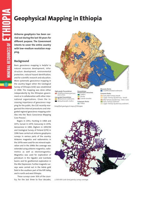
High-grade Precambrian<br />
Undifferentiated gneisses<br />
and schists<br />
Low-grade Precambrian<br />
Metavolcano-sediments<br />
Metaultramafic-mafics<br />
Addis Ababa<br />
Ma<strong>in</strong> Ethipoian Rift<br />
Precambrian<br />
Phanerozoic Intrusives<br />
Gabbro<br />
Diorite<br />
Granite-tonalite<br />
Palaeozoic Rocks<br />
Tillites<br />
Simplified geological map of <strong>Ethiopia</strong>.<br />
1:500 000 scale land gravity survey coverage.<br />
Mesozoic Rocks<br />
Undifferentiated sediments<br />
Geology: Modified from Mengesha et al.(1996)<br />
Geological map of <strong>Ethiopia</strong>, second edition, 1:2,000,000<br />
Cenozoic Rocks<br />
Early-Mid Tertiary basalt<br />
Upper Tertiary-Quaternary - basalt<br />
Mid Tertiary-Quaternary - felsic rocks<br />
Early Tertiary sediment<br />
Upper Tertiary-Quaternary sediment
Airborne Surveys (purpose, flightl<strong>in</strong>e)<br />
, 10<br />
gold exploration, 0.2<br />
hydrocarbon exploration, 3<br />
hydrocarbon exploration, 4.8<br />
hydrocarbon exploration, 5<br />
hydrocarbon exploration, 7<br />
hydrocarbon exploration, 8<br />
m<strong>in</strong>eral exploration (unspecified), 1<br />
Capital<br />
City<br />
Regions<br />
Dry Road<br />
Ma<strong>in</strong> Road<br />
M<strong>in</strong>istry of M<strong>in</strong>es of <strong>Ethiopia</strong><br />
Dear Investors,<br />
MINERAL RESOURCES OF<br />
Airborne geophysical (EM, Rad, Mag) survey coverage of <strong>Ethiopia</strong>.<br />
gravity surveys on different scales have been<br />
carried out <strong>in</strong> different parts of the country.<br />
However, more systematic, regional gravity<br />
surveys (1:500 000) were conducted from<br />
1985 to 1996 <strong>in</strong> south and southwest<br />
<strong>Ethiopia</strong> with the f<strong>in</strong>ancial assistance of<br />
SIDA/SAREC (the Swedish Government) and<br />
<strong>in</strong> collaboration with the <strong>Geophysical</strong> Ob -<br />
servatory of Addis Ababa University. From<br />
2001, the GSE has <strong>in</strong>dependently conducted<br />
the regional gravity survey. At present 80% of<br />
the country is covered.<br />
Future projects<br />
km<br />
0 50 100 200 300 400<br />
The <strong>Ethiopia</strong>n Government has approved a<br />
five-year growth and transformation strategic<br />
plan (2011-2015). In l<strong>in</strong>e with this strategic<br />
framework it has been decided to:<br />
• Cover the country by low–medium resolution,<br />
airborne geophysical surveys<br />
• Compile 1:500 000 scale gravity map of<br />
<strong>Ethiopia</strong><br />
• Increase the coverage of the 1:250000<br />
scale gravity map to 49%.<br />
We take this opportunity to welcome you<br />
to <strong>Ethiopia</strong>.<br />
We promise to make every possible effort<br />
to provide you with all required <strong>in</strong>formation<br />
on the m<strong>in</strong>eral sector <strong>in</strong> <strong>Ethiopia</strong>.<br />
If you require <strong>in</strong>formation on the m<strong>in</strong><strong>in</strong>g<br />
law, licens<strong>in</strong>g conditions and the <strong>in</strong>vestment<br />
climate <strong>in</strong> <strong>Ethiopia</strong>, please contact<br />
the M<strong>in</strong>eral Licens<strong>in</strong>g and Adm<strong>in</strong>istration<br />
Department:<br />
M<strong>in</strong>istry of M<strong>in</strong>es<br />
M<strong>in</strong>eral Licens<strong>in</strong>g and Adm<strong>in</strong>istration<br />
Department<br />
P.O. Box 486<br />
Addis Ababa, <strong>Ethiopia</strong><br />
Tel. +251 11 6461214<br />
Fax +251 11 6463454<br />
Email: <strong>in</strong>formation@mome.gov.et<br />
www.mome.gov.et<br />
The plane used by the Geological Survey of F<strong>in</strong>land<br />
(GTK) for airborne geophysical measurements.<br />
Photos. Kai Nyman.<br />
If you require <strong>in</strong>formation on the geology<br />
and m<strong>in</strong>eral opportunities <strong>in</strong> <strong>Ethiopia</strong>,<br />
please contact the Geological Survey of<br />
<strong>Ethiopia</strong> (GSE):<br />
Geological Survey of <strong>Ethiopia</strong><br />
P.O. Box 2303<br />
Addis Ababa, <strong>Ethiopia</strong><br />
Tel. +251 6 463325<br />
Fax +251 6 463326<br />
Future geoscience mapp<strong>in</strong>g projects.<br />
Email: Survey@ethionet.et<br />
www.geology.gov.et<br />
We are look<strong>in</strong>g forward to your m<strong>in</strong><strong>in</strong>g<br />
<strong>in</strong>vestment <strong>in</strong> <strong>Ethiopia</strong>.<br />
Prepared with assistance from GEUS.<br />
December 2010