Chapter 5, Google Earth Project - W.H. Freeman
Chapter 5, Google Earth Project - W.H. Freeman
Chapter 5, Google Earth Project - W.H. Freeman

Create successful ePaper yourself
Turn your PDF publications into a flip-book with our unique Google optimized e-Paper software.
<strong>Google</strong> <strong>Earth</strong> <strong>Project</strong><br />
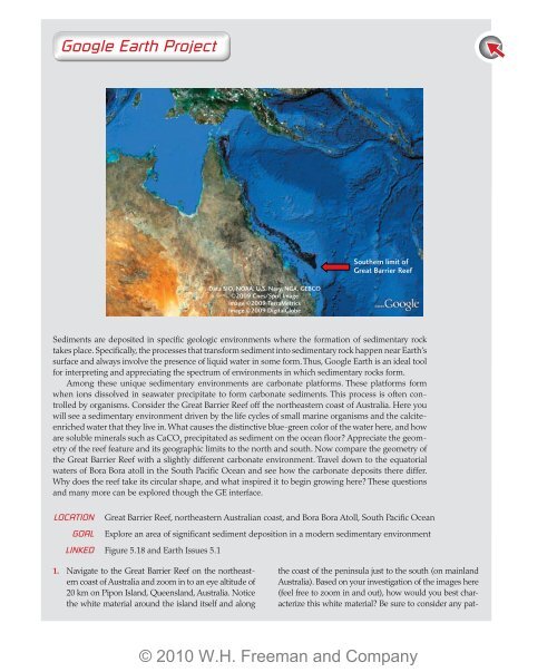
Southern limit of<br />
Great Barrier Reef<br />
Data SIO, NOAA, U.S. Navy, NGA, GEBCO<br />
©2009 Cnes/Spot Image<br />
Image ©2009 TerraMetrics<br />
Image ©2009 DigitalGlobe<br />
Sediments are deposited in specific geologic environments where the formation of sedimentary rock<br />
takes place. Specifically, the processes that transform sediment into sedimentary rock happen near <strong>Earth</strong>’s<br />
surface and always involve the presence of liquid water in some form. Thus, <strong>Google</strong> <strong>Earth</strong> is an ideal tool<br />
for interpreting and appreciating the spectrum of environments in which sedimentary rocks form.<br />
Among these unique sedimentary environments are carbonate platforms. These platforms form<br />
when ions dissolved in seawater precipitate to form carbonate sediments. This process is often controlled<br />
by organisms. Consider the Great Barrier Reef off the northeastern coast of Australia. Here you<br />
will see a sedimentary environment driven by the life cycles of small marine organisms and the calciteenriched<br />
water that they live in. What causes the distinctive blue-green color of the water here, and how<br />
are soluble minerals such as CaCO 3<br />
precipitated as sediment on the ocean floor Appreciate the geometry<br />
of the reef feature and its geographic limits to the north and south. Now compare the geometry of<br />
the Great Barrier Reef with a slightly different carbonate environment. Travel down to the equatorial<br />
waters of Bora Bora atoll in the South Pacific Ocean and see how the carbonate deposits there differ.<br />
Why does the reef take its circular shape, and what inspired it to begin growing here These questions<br />
and many more can be explored though the GE interface.<br />
Location Great Barrier Reef, northeastern Australian coast, and Bora Bora Atoll, South Pacific Ocean<br />
Goal Explore an area of significant sediment deposition in a modern sedimentary environment<br />
Linked Figure 5.18 and <strong>Earth</strong> Issues 5.1<br />
1. Navigate to the Great Barrier Reef on the northeastern<br />
coast of Australia and zoom in to an eye altitude of<br />
20 km on Pipon Island, Queensland, Australia. Notice<br />
the white material around the island itself and along<br />
the coast of the peninsula just to the south (on mainland<br />
Australia). Based on your investigation of the images here<br />
(feel free to zoom in and out), how would you best characterize<br />
this white material Be sure to consider any pat-<br />
© 2010 W.H. <strong>Freeman</strong> and Company
terns you see in the distribution of this coastal material<br />
when choosing an answer.<br />
a. Unconsolidated carbonate sediment<br />
b. Large boulder deposits<br />
c. Cemented olivine sand<br />
d. Deltaic siliciclastic mudstone<br />
2. From Pipon Island, zoom out to an eye altitude of<br />
2300 km and appreciate the length of the offshore<br />
reef features paralleling the coast. Use the path<br />
measurement tool in GE to determine the approximate<br />
length of this reef system.<br />
a. 2000 km<br />
b. 1400 km<br />
c. 2800 km<br />
d. 750 km<br />
3. Notice that the Great Barrier Reef provides some protection<br />
to the coastal environment where it is present.<br />
As you follow the reef to the south, it becomes<br />
less distinct and provides less coastal protection. At<br />
the southern end of the reef, waves from the open<br />
South Pacific are free to break on the Australian coast,<br />
and some of the best surfing in the world results. At<br />
approximately what southerly latitude does the reef<br />
system end<br />
a. 10°30'23'' S; 143°30'06'' E<br />
b. 17°56'25'' S; 146°42'57'' E<br />
c. 24°39'49'' S; 153°15'18'' E<br />
d. 21°06'31'' S; 151°38'53'' E<br />
4. Following up on questions 2 and 3, the Great Barrier<br />
Reef provides protection to the Australian coastline<br />
and allows for sedimentary processes to occur there.<br />
As one moves farther from the equator to latitudes<br />
of 25° S, it is clear that reef formation stops. Consider<br />
the conditions in which reef-building organisms<br />
precipitate calcium carbonate. What might be<br />
the primary climate-related factor controlling the<br />
southern limit of the Great Barrier Reef<br />
a. Sea surface temperatures of less than 18°C<br />
b. The depth of ocean water along the coast to the<br />
south<br />
c. The amount of sediment on the beaches near<br />
Brisbane<br />
d. The color of the seawater along the coast south<br />
of 25°<br />
Optional Challenge Question<br />
5. Now let’s travel to warmer climes by typing “Bora<br />
Bora atoll” into the GE search window and zooming<br />
in to an eye altitude of 20 km once you arrive there.<br />
In contrast to the Great Barrier Reef, this island in<br />
the South Pacific has a very limited reef system, yet<br />
that reef system has a unique geometry. The formation<br />
of an atoll like this one involves a unique relationship<br />
between biotic and geologic factors. From<br />
your observation and exploration of the atoll, which<br />
pair of biotic and abiotic factors properly reflects the<br />
relationship present here<br />
a. Birds and quartz sand beaches<br />
b. Coral reefs and volcanic islands<br />
c. Foraminifera and outcrops of marine shale<br />
d. Whales and carbonate platforms<br />
© 2010 W.H. <strong>Freeman</strong> and Company