LN200 SPAN - Canal Geomatics
LN200 SPAN - Canal Geomatics
LN200 SPAN - Canal Geomatics

You also want an ePaper? Increase the reach of your titles
YUMPU automatically turns print PDFs into web optimized ePapers that Google loves.
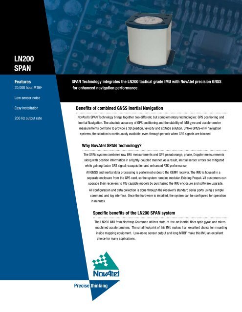
<strong>LN200</strong><br />
<strong>SPAN</strong><br />
Features<br />
20,000 hour MTBF<br />
<strong>SPAN</strong> Technology integrates the <strong>LN200</strong> tactical grade IMU with NovAtel precision GNSS<br />
for enhanced navigation performance.<br />
Low sensor noise<br />
Easy installation<br />
200 Hz output rate<br />
Benefits of combined GNSS Inertial Navigation<br />
NovAtel’s <strong>SPAN</strong> Technology brings together two different, but complementary technologies: GPS positioning and<br />
Inertial Navigation. The absolute accuracy of GPS positioning and the stability of IMU gyro and accelerometer<br />
measurements combine to provide a 3D position, velocity and attitude solution. Unlike GNSS-only navigation<br />
systems, the solution is continuously available, even through periods when GPS signals are blocked.<br />
Why NovAtel <strong>SPAN</strong> Technology<br />
The <strong>SPAN</strong> system combines raw IMU measurements and GPS pseudorange, phase, Doppler measurements<br />
along with position information in a tightly-coupled manner. As a result, inertial sensor errors are mitigated<br />
while gaining faster GPS signal reacquisition and enhanced RTK performance.<br />
All GNSS and inertial data processing is performed onboard the OEMV receiver. The IMU is housed in a<br />
separate enclosure from the GPS card, so the system remains modular. Existing Propak-V3 customers can<br />
upgrade their receivers to INS capable models by purchasing the IMU enclosure and software upgrade.<br />
All configuration and data collection is done through the receiver’s standard serial ports using a simple<br />
command and log interface. Once the hardware is installed, the system can be configured for operation<br />
in minutes.<br />
Specific benefits of the <strong>LN200</strong> <strong>SPAN</strong> system<br />
The <strong>LN200</strong> IMU from Northrop Grumman utilizes state-of-the-art inertial fiber optic gyros and micromachined<br />
accelerometers. The small footprint of this IMU makes it an excellent choice for mounting<br />
inside mapping equipment. Low-noise sensor output and long MTBF make this IMU an excellent<br />
choice for many applications.<br />
Precise thinking
<strong>LN200</strong> <strong>SPAN</strong><br />
<strong>SPAN</strong> System Performance 1<br />
IMU Performance<br />
IMU Physical & Electrical<br />
Position Accuracy<br />
Single Point L1<br />
Single Point L1/L2<br />
WAAS L1 only<br />
WAAS L1/L2<br />
DGPS<br />
RT-20 2<br />
RT-2<br />
Velocity Accuracy<br />
Attitude Accuracy<br />
Pitch<br />
Roll<br />
Azimuth<br />
Acceleration Accuracy<br />
Max Velocity 3<br />
Max Altitude 3<br />
Data Rate 4<br />
IMU Measurements<br />
INS Position<br />
INS Velocity<br />
INS Attitude<br />
1.8 m CEP<br />
1.5 m CEP<br />
1.2 m CEP<br />
0.8 m CEP<br />
0.45 m CEP<br />
< 20 cm CEP<br />
1 cm + 1ppm CEP<br />
0.02 m/s RMS<br />
(nominal)<br />
0.015 0 RMS<br />
0.015 0 RMS<br />
0.05 0 RMS<br />
0.03 m/s 2 RMS<br />
514 m/s<br />
18,288 m<br />
200 Hz<br />
200 Hz<br />
200 Hz<br />
200 Hz<br />
IMU-<strong>LN200</strong><br />
Gyro Input Range<br />
+<br />
1000 deg/sec<br />
Gyro Rate Bias<br />
1.0 deg/hr<br />
Gyro Rate Scale Factor<br />
100 ppm<br />
Angular Random Walk 0.07 deg/hr<br />
Accelerometer Range<br />
+<br />
40 g<br />
Accelerometer Linearity 150 ppm<br />
Accelerometer Scale Factor 300 ppm<br />
Accelerometer Bias<br />
0.3 mg<br />
1 Typical values. Performance specifications subject<br />
to GPS system characteristics, US DOD operational<br />
degradation, ionospheric and tropospheric conditions,<br />
satellite geometry, baseline length, multipath effects<br />
and the presence of intentional or unintentional<br />
interference sources.<br />
2 Expected accuracy after static convergence.<br />
3 Export licensing restricts operation to a maximum of<br />
18,288 meters and 514 meters per second.<br />
4 If raw IMU measurements are logged (200 Hz), the<br />
max rate position, velocity, attitude logs can be<br />
requested is 50 Hz.<br />
5 These values were computed using forced GPS<br />
outages in data collected under good GPS availability<br />
conditions in a land vehicle. The errors are calculated<br />
as the difference between the full availability trajectory<br />
and the the trajectory with forced GPS outages.<br />
Size<br />
Weight<br />
Power<br />
Power Consumption<br />
Input Voltage<br />
135 x 1153 x 130 mm<br />
750 g<br />
12 W (typical)<br />
+ 9 to 28 V<br />
Input/Output Connectors<br />
Power<br />
MIL-C-38999-III, 3 pin<br />
Communication MIL-C-38999-III, 13 pin<br />
Environmental<br />
Temperature<br />
Operating<br />
Storage<br />
Humidity<br />
MTBF<br />
-30°C to +60°C<br />
-45°C to +80°C<br />
95% non-condensing<br />
20,000 hrs<br />
Performance During GPS Outages 5<br />
Outage<br />
Duration<br />
Positioning<br />
Mode<br />
Position Error<br />
(m)<br />
Velocity Error<br />
(m/s)<br />
Attitude Error<br />
(degrees)<br />
Horizontal Vertical Horizontal Vertical Roll Pitch Yaw<br />
10 s RTK 0.11 0.04 0.012 0.003 0.003 0.003 0.006<br />
DGPS 0.33 0.32 0.020 0.008 0.005 0.005 0.023<br />
SP 1.07 1.97 0.024 0.010 0.005 0.005 0.030<br />
30 s RTK 0.59 0.18 0.036 0.008 0.006 0.005 0.014<br />
DGPS 0.73 0.42 0.038 0.010 0.006 0.006 0.026<br />
SP 1.38 2.01 0.043 0.013 0.006 0.006 0.033<br />
60 s RTK 2.03 0.61 0.072 0.020 0.007 0.008 0.023<br />
DGPS 2.11 0.65 0.069 0.014 0.006 0.007 0.030<br />
SP 2.68 2.05 0.075 0.015 0.006 0.007 0.036<br />
Precise thinking<br />
Version 1 - Specifications subject to change without notice.<br />
© 2006 NovAtel Inc. All rights reserved. Printed in Canada. D10151<br />
www.novatel.com<br />
1-800-NOVATEL (U.S. & Canada) or 403-295-4900 | Europe +44 1993 852-436 | Fax 403-295-4901 | E-mail sales@novatel.com