Section 4 Part 2 - Umgeni Water
Section 4 Part 2 - Umgeni Water
Section 4 Part 2 - Umgeni Water

Create successful ePaper yourself
Turn your PDF publications into a flip-book with our unique Google optimized e-Paper software.
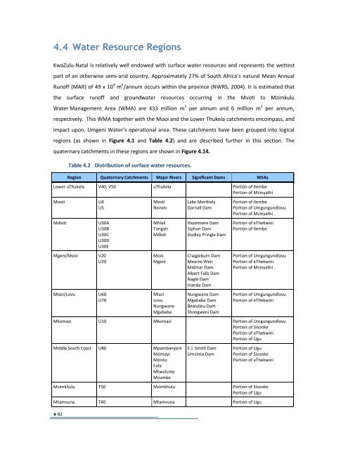
4.4 <strong>Water</strong> Resource Regions<br />
KwaZulu-Natal is relatively well endowed with surface water resources and represents the wettest<br />
part of an otherwise semi-arid country. Approximately 27% of South Africa’s natural Mean Annual<br />
Runoff (MAR) of 49 x 10 9 m 3 /annum occurs within the province (NWRS, 2004). It is estimated that<br />
the surface runoff and groundwater resources occurring in the Mvoti to Mzimkulu<br />
<strong>Water</strong> Management Area (WMA) are 433 million m 3 per annum and 6 million m 3<br />
82<br />
per annum,<br />
respectively. This WMA together with the Mooi and the Lower Thukela catchments encompass, and<br />
impact upon, <strong>Umgeni</strong> <strong>Water</strong>’s operational area. These catchments have been grouped into logical<br />
regions (as shown in Figure 4.1 and Table 4.2) and are described further in this section. The<br />
quaternary catchments in these regions are shown in Figure 4.14.<br />
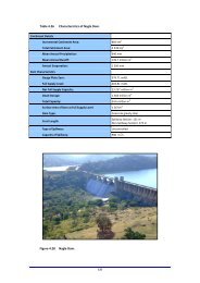
Table 4.2 Distribution of surface water resources.<br />
Region Quaternary Catchments Major Rivers Significant Dams WSAs<br />
Lower uThukela V40, V50 uThukela Portion of Ilembe<br />
Portion of Mzinyathi<br />
Mvoti<br />
Mdloti<br />
Mgeni/Mooi<br />
Mlazi/Lovu<br />
U4<br />
U5<br />
U30A<br />
U30B<br />
U30C<br />
U30D<br />
U30E<br />
V20<br />
U20<br />
U60<br />
U70<br />
Mvoti<br />
Nonoti<br />
Mhlali<br />
Tongati<br />
Mdloti<br />
Mooi<br />
Mgeni<br />
Mlazi<br />
Lovu<br />
Nungwane<br />
Mgababa<br />
Lake Merthely<br />
Darnall Dam<br />
Hazelmere Dam<br />
Siphon Dam<br />
Dudley Pringle Dam<br />
Craigieburn Dam<br />
Mearns Weir<br />
Midmar Dam<br />
Albert Falls Dam<br />
Nagle Dam<br />
Inanda Dam<br />
Nungwane Dam<br />
Mgababa Dam<br />
Bealulieu Dam<br />
Shongweni Dam<br />
Portion of Ilembe<br />
Portion of Umgungundlovu<br />
Portion of Mzinyathi<br />
Portion of eThekwini<br />
Portion of Ilembe<br />
Portion of Umgungundlovu<br />
Portion of eThekwini<br />
Portion of Mzinyathi<br />
Portion of Umgungundlovu<br />
Portion of eThekwini<br />
Mkomazi U10 Mkomazi Portion of Umgungundlovu<br />
Portion of Sisonke<br />
Portion of eThekwini<br />
Portion of Ugu<br />
Middle South Coast U80 Mpambanyoni<br />
Mzimayi<br />
Mzinto<br />
Fafa<br />
Mtwalume<br />
Mzumbe<br />
E.J. Smith Dam<br />
Umzinto Dam<br />
Portion of Ugu<br />
Portion of Sisonke<br />
Portion of eThekwini<br />
Mzimkhulu T50 Mzimkhulu Portion of Sisonke<br />
Portion of Ugu<br />
Mtamvuna T40 Mtamvuna Portion of Ugu
Figure 4.14 Quaternary<br />
catchments.<br />
83
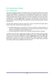
4.4.1 Lower uThukela Region<br />
The Lower uThukela region (Figure 4.15) comprises the lower portion of the uThukela River, one the<br />
largest rivers within the country. The water resources of the uThukela River have been substantially<br />
allocated to users within the uThukela basin itself, to inter-basin transfers to the Vaal, and to the<br />
Mhlathuze catchment.<br />
This region consists of the tertiary catchments V40 and V50, and quaternary catchments V33C, V33D<br />
and V60K, and includes the town of Mandini and the Isithebe industrial area.<br />
Surface <strong>Water</strong><br />
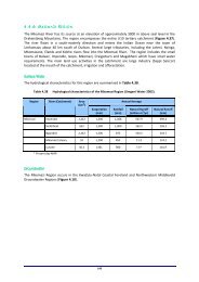
The hydrological characteristics for this region are summarised in Table 4.3.<br />
Table 4.3<br />
Hydrological characteristics of the Lower uThukela Region (WR90).<br />
Region<br />
River (Catchment)<br />
Area<br />
(km 2 )<br />
Evaporation<br />
(mm)<br />
Rainfall<br />
(mm)<br />
Annual Average<br />
Natural Runoff<br />
(million m 3 /annum)<br />
Natural Runoff<br />
(mm)<br />
Lower uThukela uThukela River (lower portion) 4 183 1 340 848 434 104<br />
Groundwater<br />
The Lower uThukela region occurs in the KwaZulu-Natal Coastal Foreland Groundwater Region<br />
(Figure 4.16). This Groundwater Region is characterised by fractured aquifers which are formed by<br />
predominantly arenaceous rocks consisting of sandstone and diamictite that is Dwyka tillite.<br />
Hydrogeological Units<br />
The area is entirely underlain by hard rocks (Granites) of the Basement Complex and compacted<br />
sedimentary strata of the Natal Group Sandstone (NGS) and Karoo Supergroup.<br />
Geohydrology<br />
Eighty nine percent of all reported borehole yields are less than 3 l/s, confirming that overall the<br />
groundwater resources are moderately poor to marginal.<br />
84
Figure 4.15 General layout of<br />
the uThukela<br />
Region.<br />
85
Figure 4.16 Groundwater regions<br />
(2nd Edition).<br />
86
Figure 4.17 Groundwater potential<br />
in the uThukela<br />
Region.<br />
87
Groundwater Potential<br />
The development potential in the area (Figure 4.17) can be classified as moderate, where resources<br />
are, on average, suitable for development of small reticulation schemes for small villages, schools,<br />
clinics and hospitals. Recharge calculations indicate the potential groundwater resources are<br />
underutilised: less than 25% of potentially available groundwater is presently used.<br />
<strong>Water</strong> Quality<br />
The groundwater quality is generally good with an electrical conductivity (EC) of 450 mg/l (less than<br />
70 mS/m). The water quality in the uThukela Valley is classified as acceptable with EC between 70<br />
and 300 mS/m. The groundwater quality poses no limitation to use for human consumption, and is<br />
not therefore a constraint to development.<br />
Reserve<br />
<strong>Water</strong> for the ecological Reserve is water that must remain in the river and may not be abstracted.<br />
This is expressed as an estimated reduction in available yield and shown as part of the resource.<br />
As part of the “Thukela Reserve Determination Study” (2004b), a comprehensive water resource<br />
evaluation assessment indicated a substantial surplus in the uThukela WMA even after meeting the<br />
Reserve requirements. However, in the uThukela <strong>Water</strong> Management Area ISP it is reported that<br />
“after careful review and consideration of the Reserve Study results, it became clear that<br />
assumptions made for the Reserve Study, while valid for Reserve determination, are not valid for the<br />
allocation of water in the uThukela WMA today or in the short-term”. The reasons for this are as<br />
follows:<br />
• The uThukela Reserve water resource analysis assumed that the Reserve will be met through<br />
the application of curtailments to users throughout the catchment. This curtailment results in<br />
surplus water becoming available in the lower reaches of the uThukela River.<br />
• The uThukela Reserve water resource analysis assumed that the Spioenkop, Ntshingwayo and<br />
Wagendrift dams will all contribute to the users and the Reserve in the Lower uThukela. The<br />
conjunctive use of these three dams results in large theoretical surpluses in the<br />
Lower uThukela.<br />
88
• The methodology used in the uThukela Reserve analysis, whereby the excess yield is<br />
determined at the bottom of each key area, represents the best-case scenario. If the yield is<br />
required further upstream in the catchment then the excess yield is less. The reason for this is<br />
that releases are only made from the large dams to meet the users' shortfalls after they have<br />
made use of run-of-river yields. The further downstream a user is situated, the more run-ofriver<br />
yield becomes available, with the result that less water needs to be released from the<br />
dams and hence more surplus is available.<br />
<strong>Water</strong> Balance/Availability<br />
This region appears to be in balance even after making an allowance for the Ecological Reserve.<br />
<strong>Umgeni</strong> <strong>Water</strong> applied for an abstraction licence of 40.2 million m 3 /annum (110 Ml/day) from DWA<br />
during the financial year 2010/11. According to the uThukela <strong>Water</strong> Management Internal Strategic<br />
Perspectives (ISP) (DWA, 2004) it is estimated that there is about 45 million m 3 /annum (120 Ml/day)<br />
which is not allocated. The main water abstractions in the Lower uThukela Area were identified as<br />
follows:<br />
• Middeldrift abstractions consisting of the transfer scheme that takes water to the<br />
Mhlathuze River System, and the recently developed scheme supplying water to the Ngcebo<br />
communities (Figure 4.15 and Table 4.3) located south of the uThukela River.<br />
• The abstraction situated upstream of Mandini supplying the Sundumbili WTP which serves<br />
Sundumbili and the surrounding areas.<br />
• The abstraction supplying the uThukela paper mill of SAPPI, including the town of Mandini.<br />
• Irrigation demands in the main river course situated in the Lower uThukela area.<br />
Existing Infrastructure and Yield<br />
Currently the Lower uThukela catchment is unregulated and does not have any significant water<br />
resource infrastructure on it. Major abstractions are all run-of-river as discussed in the preceding<br />
section.<br />
89
Proposed <strong>Water</strong> Resource Infrastructure<br />
Whilst the ultimate DWA strategy is to transfer uThukela River water northwards to meet the future<br />
demands of the Richards Bay area, this water is not required for that area in the near future. Hence,<br />
the uThukela River has been identified as a potential water resource to supply the North Coast area<br />
(i.e. south of the uThukela River) in the medium and possibly the long-term. A total amount of<br />
40 million m 3 /annum (approximately 110 Ml/day) is available in the Lower uThukela Region for<br />
abstraction for urban and domestic supply. The storage dams in the upper reaches of the uThukela<br />
catchment (including the planned Spring Grove Dam) will need to make releases in the winter<br />
months to ensure this quantity is always available.<br />
<strong>Umgeni</strong> <strong>Water</strong> is currently concluding the design of the Lower Thukela Bulk <strong>Water</strong> Supply Scheme<br />
(this scheme is discussed in <strong>Section</strong> 4.4). The scheme will include an abstraction works situated on<br />
the uThukela River in the vicinity of Mandini (Figure 4.18), utilising a run-of-river abstraction<br />
mechanism. The works will initially abstract 20 million m 3 /annum (55 Ml/day) and will be upgraded<br />
to 40 million m 3 /annum (110 Ml/day) at a later stage when needed to meet growth requirements.<br />
4.4.2 Mvoti Region<br />
The Mvoti region comprises two tertiary catchments, viz. U40 (Mvoti River) and U50 (Nonoti River)<br />
(Figure 4.19).<br />
Land cover consists primarily of communal land in the inland areas, commercial timber in the upper<br />
reaches of the Mvoti catchment and dryland and irrigated sugar cane along the coastal strip.<br />
The urban and peri-urban areas of the town of KwaDukuza (previously known as Stanger), Greytown,<br />
Zinkwazi, Darnall and Groutville are located within this region. The town of KwaDukuza relies on runof-river<br />
abstractions from the Mvoti River, supported by water transfers from the Mdloti catchment.<br />
Groutville also uses water transfers from the Mdloti catchment. Zinkwazi utilises local groundwater<br />
resources, while Greytown relies on Lake Merthley and groundwater. The Darnall Dam on the Nonoti<br />
River supports the town of Darnall.<br />
90
Figure 4.18 Proposed water<br />
resource<br />
infrastructure in the<br />
Lower uThukela<br />
Region.<br />
91
Figure 4.19 General layout of the<br />
Mvoti region.<br />
92
Surface <strong>Water</strong><br />
The hydrological characteristics of the catchments in the Mvoti region are shown in Table 4.4.<br />
Table 4.4<br />
Hydrological characteristics for the Mvoti region (WR90).<br />
Annual Average<br />
Region<br />
River (Catchment)<br />
Area<br />
(km 2 )<br />
Evaporation<br />
(mm)<br />
Rainfall<br />
(mm)<br />
Natural Runoff<br />
(million<br />
m 3 /annum)<br />
Natural Runoff<br />
(mm)<br />
Mvoti Nonoti River (U50) 179 1 250 1 056 35.8 200<br />
Mvoti River (U40) 3 035 1 223 892 435.0 143<br />
Groundwater<br />
The Mvoti region occurs in the KwaZulu-Natal Coastal Foreland Groundwater Region (Figure 4.16).<br />
This Groundwater Region is characterised by fractured aquifers which are formed by predominantly<br />
arenaceous rocks consisting of sandstone and diamictite that is Dwyka tillite.<br />
Hydrogeological Units<br />
The hydrogeologically relevant lithologies recognised in the study area comprise sandstone, tillite<br />
and mudstone/shale supporting fractured groundwater regimes and dolerite intrusions and<br />
granite/gneiss supporting fractured and weathered groundwater regimes.<br />
Geohydrology<br />
Natural groundwater discharge occurs in the form of springs, seeps and in isolated cases, uncapped<br />
artesian boreholes. The wetlands and dams in the headwaters of the Mvoti River are supported by<br />
perennial groundwater seeps associated with the dolerite sill intrusions in the mudstone/shale<br />
lithologies. Springs rising in the sandstone and granite/gneiss lithologies relate to structural features<br />
(faults and fracture zones, lineaments). An analysis of baseflow-derived stream runoff values per<br />
quaternary catchment suggests that groundwater recharge from rainfall varies in the range 3% to 7%<br />
of the mean annual precipitation.<br />
93
Figure 4.20 Groundwater<br />
potential in the Mvoti<br />
Region.<br />
94
Groundwater Potential<br />
The greatest widespread demand on the groundwater resources in this catchment is represented by<br />
its use as a source of potable water for communities in the rural areas and, to a lesser extent,<br />
households in the farming areas. Other demands of a more concentrated nature are represented by<br />
its use to supplement rainfall and traditional surface water supplies for irrigation.<br />
The sandstone of the Natal Group represents the most productive groundwater-bearing lithology,<br />
followed by mudstone/shale lithologies, the granite/gneiss lithologies and the tillite sediments of the<br />
Dwyka Tillite Formation.<br />
A good to fair correlation exists between boreholes supporting yields in the moderate (greater than<br />
0.5 l/s to less than 3.0 l/s) and high (greater than 3.0 l/s) classification ranges and structural features<br />
represented by faults and remotely sensed lineaments.<br />
The groundwater potential is particularly high (greater than 3.0 l/s) in the upper catchment in the<br />
Natal Group sandstones in a band just south of the towns Greytown, Kranskop and Seven Oaks<br />
(Figure 4.20).<br />
<strong>Water</strong> Quality<br />
The Mvoti <strong>Water</strong> Treatment Plant (WTP) abstracts raw water from the Mvoti River for treatment<br />
and supply of potable water. Turbidity seems to have been a problem in this catchment during 2011<br />
as there are a significant number of instances when the Resource Quality Objectives (RQO) have<br />
been exceeded (Figure 4.21). High turbidity values are contributed by the sand mining activities<br />
upstream of the plant.<br />
95
96<br />
Figure 4.21 Percentage compliance vs. non-compliance with the Resource Quality<br />
Objective for Mvoti.
Reserve<br />
The ecological Reserve of the Mvoti River was determined in the late 1990’s before the reserve<br />
determination techniques and methodologies were refined and standardised across the country.<br />
Hence, the Reserve has not been implemented to date and will need to be recalculated at a<br />
comprehensive level using the standardised methodology. Notwithstanding this, the highly stressed<br />
nature of the catchment is a clear indication that it is unlikely that the Reserve will be fully met if<br />
implemented. This is particularly the case during dry periods, while in the wetter periods the Reserve<br />
is more likely to be met. The implementation of the ecological Reserve in the catchment will result in<br />
the aggravation of the current situation, which is already marked by periods of curtailments during<br />
low flows.<br />
Based on a desktop analysis (DWAF 2004), the ecological requirement is estimated to be 22% of the<br />
MAR for a Class C Ecological Management Category. The impact of this on the available yield is<br />
estimated at 10million m 3 /annum (27 Ml/day). The broad strategy for this catchment will most likely<br />
be to implement the ecological Reserve in a phased manner together with compulsory licensing to<br />
deal with the issue of over-allocation.<br />
<strong>Water</strong> Balance/Availability<br />
According to the Mvoti to Mzimkhulu ISP (DWA, 2004) the water balance of the Mvoti region is in<br />
deficit of 56 million m 3 /annum. <strong>Umgeni</strong> <strong>Water</strong> applied for an abstraction licence of<br />
6.57 million m 3 /annum (18 Ml/day) from the Mvoti River for the Mvoti WTP during the financial year<br />
2010/11. Another abstraction licence application of 2.56 million m 3 /annum (7 Ml/day) was made for<br />
the proposed Imvutshane Dam in the Hlimbitwa catchment which is a tributary of the Mvoti River.<br />
Existing Infrastructure and Yields<br />
Surface <strong>Water</strong><br />
There are no major storage dams on the Mvoti or Nonoti rivers and consequently the available yield<br />
from this system is limited. Lake Merthley, situated in the upper reaches of the Mvoti catchment,<br />
and the Darnall Dam on the Nonoti River are the only dams of any significance in this region.<br />
The Mvoti Region has a high MAR, however, the high sediment loads on the main rivers make the<br />
development of small dams on these rivers non-viable. Large storage dams or off-channel storage<br />
97
dams are therefore required. Table 4.5 shows a summary of existing water resource statistics.<br />
Table 4.5<br />
Existing Dams in the Mvoti Region.<br />
Impoundment<br />
River<br />
Capacity<br />
(million m 3 )<br />
Purpose<br />
Lake Merthely Heine 1.98 Domestic<br />
Darnall Dam Nonoti 0.3 Domestic<br />
Table 4.6<br />
Yield information for the existing water resource abstractions in the<br />
Mvoti Region.<br />
Impoundment<br />
River<br />
Capacity<br />
(million m 3 )<br />
Yield<br />
(million m 3 /annum)<br />
Stochastic Yield<br />
(million m 3 /annum)<br />
Historical 1:50 1:100<br />
Mvoti Run-of-River at<br />
Mvoti WTP<br />
Lake Merthely<br />
Darnall Dam<br />
Mvoti 0 Not Available<br />
Heinespruit<br />
(tributary of the Mvoti)<br />
1.98<br />
0.74<br />
(2.02 Ml/day)<br />
Nonoti 0.3 Not Available<br />
3.3<br />
(9.0 Ml/day)<br />
0.95<br />
(2.60 Ml/day)<br />
1.8<br />
(4.9 Ml/day)<br />
Not Available<br />
0.89<br />
(2.44 Ml/day)<br />
1.1<br />
(3.0 Ml/day)<br />
Groundwater<br />
<strong>Umgeni</strong> <strong>Water</strong> operates the Efaye groundwater scheme on behalf of the<br />
Umgungundlovu District Municipality. The Efaye community is situated just north of Mount Elias.<br />
The scheme is supplied by two production boreholes. The sustainable yield of the two production<br />
boreholes supplying the Efaye scheme is approximately 256 kl/day, although the demand is far<br />
greater and new groundwater resources to augment the scheme are required. <strong>Umgeni</strong> <strong>Water</strong><br />
completed a groundwater resources investigation in 2010 that involved the drilling of 6 exploration<br />
boreholes. Pump testing (24 hrs) results indicate that four of the boreholes have a combined<br />
sustainable yield of 265 kl/day that can potentially be utilised to augment existing supplies. The<br />
other two boreholes were low yielding and therefore not pump tested. Preliminary infrastructure<br />
feasibility studies are currently being undertaken by <strong>Umgeni</strong> <strong>Water</strong> with a view to connecting up the<br />
new boreholes to the existing potable water distribution system.<br />
The relevant WSA’s operate boreholes to augment traditional surface water supplies in Greytown<br />
and KwaDukuza. In Greytown, six boreholes pump into the town’s water supply distribution system.<br />
The sustainable yield of the wellfield is not known, but has previously been reported as being in the<br />
98
order of 1.5 Ml/day (GCS 1993). Previous studies (<strong>Umgeni</strong> <strong>Water</strong> 1997) indicated that some of the<br />
boreholes were hydraulically linked. As the boreholes are using the same aquifer and no records of<br />
groundwater levels are being kept there is a possibility that the aquifer is being over-utilised. There<br />
are numerous rural stand-alone water supply schemes in the Mvoti catchment that currently rely on<br />
boreholes for their water supply.<br />
Sugar mills such as Dalton, Noodsberg and Glendale successfully utilise groundwater resources for<br />
industrial purposes. Numerous commercial poultry farms also utilise boreholes with success.<br />
The coastal village of Zinkwazi obtains all of its water resources from groundwater. <strong>Umgeni</strong> <strong>Water</strong><br />
operates the groundwater scheme infrastructure on behalf of Ilembe District Municipality. The<br />
scheme currently has five operational production boreholes with a combined yield of approximately<br />
1080 kl/day operating on a 24-hour pump cycle. Investigations undertaken in 2010 have shown that<br />
the current abstraction rate is unsustainable and the true yield of the borehole wellfield is closer to<br />
250 kl/day. Urgent augmentation of the water supply system is thus required and plans are<br />
underway to augment the water supply using surface water from Darnall Dam. <strong>Water</strong> from<br />
Darnall Dam will be treated at the Darnall Mill <strong>Water</strong> Treatment Plant and supplied to an existing<br />
reticulation reservoir. A new pipeline is currently being constructed from this reservoir to<br />
Zinkwazi village.<br />
Operating Rules<br />
There is an existing link between <strong>Umgeni</strong> <strong>Water</strong>’s North Coast Supply System (NCSS) (<strong>Section</strong> 5.5),<br />
which obtains water from Hazelmere Dam on the Mdloti River (<strong>Section</strong> 4.4.3), to the supply system<br />
from the Mvoti River which abstracts water for the Mvoti WTP. Thus, when the Mvoti System is<br />
unable to fully meet the demands placed on it, water from Hazelmere Dam can be delivered via the<br />
NCSS to supplement the supply. This support is limited to the capacity of the linking pipeline, which<br />
is currently 2.5 Ml/day on average.<br />
99
Proposed <strong>Water</strong> Resource Infrastructure<br />
Major Surface <strong>Water</strong> Developments<br />
The long-term macro development strategy for water supply to the KwaZulu-Natal coastal strip<br />
between Ballito and the uThukela River is logically centred around the Mvoti River and the lower<br />
reaches of the uThukela River.<br />
Investigations of the various Mvoti River options, completed in the late 1990’s, concluded that the<br />
most favourable water resource development option is the proposed Isithundu Dam (Figure 4.22),<br />
situated on the Mvoti River immediately upstream of its confluence with the Hlimbitwa River.<br />
<strong>Water</strong> would be released from the dam back into the river for abstraction by downstream irrigators.<br />
The remaining released water would be diverted through an existing weir and tunnel at Mvoti View<br />
to supply raw water into a small balancing dam situated on a tributary of the Mvoti River. <strong>Water</strong><br />
would then be pumped to the proposed Fawsley Park WTP to supply into the NCSS under gravity.<br />
Subsequent changes to legislation saw the irrigators withdrawing from the proposed scheme due to<br />
the higher cost of raw water from the scheme becoming unaffordable for them. With the resultant<br />
shift to a single purpose scheme for domestic and industrial supply only, the criteria used to select<br />
the preferred option changed. This implies that the findings of the selection process will have to be<br />
reviewed in order to confirm the preferred development option. An alternate option of developing a<br />
dam lower on the Mvoti River at Welverdient (Figure 4.22) to supply directly to the proposed<br />
Fawsley Park WTP now also needs to be considered. A detailed investigation to determine the<br />
preferred option is to be undertaken by DWA.<br />
A potential dam site in the upper reaches of the Mvoti River at Mvoti-Poort (Figure 4.22) in the<br />
vicinity of Greytown was identified during the initial investigations of supply options for the northern<br />
coastal regions. Whilst not deemed a suitable option to supply the town of KwaDukuza and<br />
surrounds, this site is considered favourable to be developed as a water resource that could support<br />
an Upper Mvoti regional bulk scheme to supply potable water to Greytown, Kranskop and<br />
surrounds on a sustainable basis in the long-term (<strong>Section</strong> 5.5). A detailed investigation of this site<br />
still needs to be undertaken by DWA.<br />
In order to supply the communities in Maphumulo, Maqumbi and Ashville, a scheme is being<br />
developed that will obtain its raw water from the Imvutshane River, which is a tributary of the<br />
Hlimbitwa River (which in turn is a tributary of the Mvoti River). A dam site has been identified on<br />
100
the Imvutshane River (Figure 4.22) which has the potential to support these communities with<br />
sufficient water in the medium to long-term. The dam can later be augmented from the<br />
Hlimbitwa River. The dam embankment is currently in the detailed design phase.<br />
Similarly, to supply the Ozwathini community a scheme has been investigated on the Sikoto River,<br />
which is a tributary of the Mvoti River. A dam site has been identified on the Sikoto River that has<br />
the potential to support this community in the medium to long-term. This scheme is an alternate<br />
short-term option to a supply from the Mgeni Sytem via an extension of the Wartburg Pipeline. The<br />
detailed feasibility of this scheme has recently been concluded.<br />
Details of the proposed water resources infrastructure developments in the Mvoti Region are given<br />
in Table 4.7.<br />
Table 4.7<br />
Proposed water resource infrastructure in the Mvoti Region.<br />
Impoundment<br />
River<br />
Capacity<br />
(million m 3 )<br />
Yield<br />
(million m 3 /annum)<br />
Stochastic Yield<br />
(million m 3 /annum)<br />
Historical 1:50 1:100 1:200<br />
Mvoti-Poort Dam Mvoti 80.1 Not Available<br />
Not<br />
Available<br />
Not Available<br />
Not<br />
Available<br />
Isithundu Dam Mvoti 51.3<br />
45<br />
(123 Ml/day)<br />
49.0<br />
(134 Ml/day)<br />
47.0<br />
(129 Ml/day)<br />
45.1<br />
(124 Ml/day)<br />
Raised Isithundu Dam Mvoti 102.0<br />
57<br />
(156 Ml/day)<br />
67.0<br />
(184 Ml/day)<br />
63.2<br />
(173 Ml/day)<br />
59.4<br />
(163 Ml/day)<br />
Welverdient Dam<br />
Mvoti<br />
108.1<br />
Not Available<br />
Not<br />
Available<br />
Not Available<br />
Not<br />
Available<br />
Imvutshane Dam Imvutshane 3.2 Not Available<br />
2.4<br />
(6.5 Ml/day)<br />
Not Available<br />
Not Available<br />
Sikoto Dam Sikoto 5.6 Not Available<br />
2.3<br />
(6.3 Ml/day)<br />
Not Available<br />
Not Available<br />
101
Figure 4.22 Proposed water<br />
resource<br />
infrastructure in the<br />
Mvoti Region.<br />
102
Imvutshane Dam<br />
An investigation has been concluded into the feasibility of supplying Maphumulo, Maqumbi and<br />
Ashville from the Imvutshane River (<strong>Section</strong> 5.5), which is a tributary of the Hlimbitwa River, which<br />
in turn is a tributary of the Mvoti River. A dam site and abstraction point has been identified on the<br />
Imvutshane River approximately 10 km south of the town of Maphumulo and approximately 1 km<br />
upstream of the confluence of the Imvutshane and Hlimbitwa rivers.<br />
At the proposed abstraction point, the run-of-river yield is approximately 1.5 million m 3 /annum<br />
(4 Ml/day) at a 98% level of assurance, and the proposed Imvutshane Dam situated at the same site<br />
on the river with augmentation from the Hlimbitwa River can yield 3.7 million m 3 /annum (10 Ml/day)<br />
at a 98% level of assurance. A water supply scheme is currently being constructed by <strong>Umgeni</strong> <strong>Water</strong><br />
that will transfer raw water directly from the river to initially supply Maphumulo and surrounding<br />
areas. Thereafter the proposed Imvutshane Dam will be constructed on the river and the supply<br />
infrastructure will be extended to supply the areas of Maqumbi and Ashville.<br />
Sikoto Dam<br />
The Ozwatini area has rural communities that are currently being supplied with water from a<br />
rudimentary water supply scheme fed from local boreholes that are insufficient and unsustainable. A<br />
dam site has been identified on the Sikoto River (<strong>Section</strong> 5.6), a tributary of the Mvoti River that can<br />
be developed as a sustainable raw water source to support a water supply scheme to the Ozwatini<br />
area. A detailed feasibility study of the proposed Sikoto Dam and the water supply infrastructure has<br />
been completed by <strong>Umgeni</strong> <strong>Water</strong>. The proposed dam will have a yield of 2.3 million m 3 /annum<br />
(6.3 Ml/day) at a 98% level of assurance.<br />
Efaye Groundwater<br />
The additional groundwater resources (265 kl/day) secured in 2010 through the drilling of six<br />
boreholes have not been equipped with pumps or water distribution infrastructure and have been<br />
capped. A decision has now been made not to equip these boreholes, but to rather connect the<br />
scheme up to the planned extension to the Wartburg pipeline.<br />
103