Deltona Urban Design Master Plan 08/26/2008 - City of Deltona ...
Deltona Urban Design Master Plan 08/26/2008 - City of Deltona ...
Deltona Urban Design Master Plan 08/26/2008 - City of Deltona ...

Create successful ePaper yourself
Turn your PDF publications into a flip-book with our unique Google optimized e-Paper software.
<strong>City</strong> <strong>of</strong> <strong>Deltona</strong> <strong>Urban</strong> <strong>Design</strong> <strong>Master</strong> <strong>Plan</strong><br />
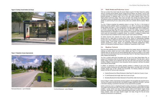
Figure 6: Existing Transit Shelters and Stops<br />
Figure 7: Pedestrian Access Improvements<br />
2.5 Multi-Modal and Pedestrian Access<br />
There are currently three transit routes that service <strong>Deltona</strong> as part <strong>of</strong> the West Volusia line, namely:<br />
Route 20, providing service between DeLand, Orange <strong>City</strong> and <strong>Deltona</strong>, and Routes 21 and 22, both<br />
providing service between portions <strong>of</strong> Debary and <strong>Deltona</strong>. These routes currently service several major<br />
potential generators <strong>of</strong> pedestrian traffic, such as <strong>City</strong> Hall, <strong>Deltona</strong> Regional Public Library and<br />
Daytona Beach Community College. These routes may better serve existing and potential customers<br />
with additional shelters and sidewalk improvements along those routes (see Figure 6). Decorative transit<br />
shelters are planned along the bus routes and they need to be consistent with the citywide “Nature”<br />
theme.<br />
The <strong>City</strong> <strong>of</strong> <strong>Deltona</strong> recognizes that pedestrian access is an issue. The <strong>City</strong> is in the process <strong>of</strong><br />
determining existing sidewalk locations and deficiencies, in an effort to encourage more pedestrian<br />
friendly facilities (see Figure 7). There is $4,200,000 in the <strong>City</strong>’s Capital Improvement Program (CIP)<br />
for sidewalk improvements, beginning with $640,000 in the 2007/20<strong>08</strong> budget. Future developments,<br />
such as the proposed State Road 472 Activity Center located in the southeast quadrant <strong>of</strong> I-4 and<br />
Howland Boulevard are anticipated to be major generators <strong>of</strong> employment, and may justify additional<br />
transit routes and improvements to pedestrian access. Any revisions or additions to existing transit<br />
routes will require close coordination with the Volusia County Transit Authority (VOTRAN).<br />
As <strong>Deltona</strong> becomes more urbanized, the need for public transit and pedestrian connectivity will<br />
become more <strong>of</strong> a viable option to commute within the <strong>City</strong>. Section 4.0 Implementation Strategies<br />
provides action steps to address the public transit system and pedestrian access through Section 4.1.2<br />
Cohesive <strong>Design</strong> (Transit Shelter Location and Amenities), Section 4.2.2 Parks and Recreation<br />
Facilities (Connectivity to Parks), Section 4.2.3 Neighborhood Residential (Neighborhood Safety),<br />
Section 4.2.6 Educational Facilities and Section 4.3 Roads and Transportation (Public Transit).<br />
2.6 Roadway Network<br />
Due to the initial residential nature <strong>of</strong> the <strong>City</strong> and the design <strong>of</strong> the roadway network, the designation <strong>of</strong><br />
roadways as arterial, collector and local is rather arbitrary (see Figure 8 on Page 6). Many <strong>of</strong> the<br />
roadways within the <strong>City</strong> that once only served residential traffic now serve as collector or even arterial<br />
roads as commercial development has occurred along State Road 415, West Saxon Boulevard and the<br />
cities <strong>of</strong> Debary and Orange <strong>City</strong>.<br />
The <strong>City</strong> is currently refining their thoroughfare plan. As part <strong>of</strong> this <strong>Urban</strong> <strong>Design</strong> <strong>Master</strong> <strong>Plan</strong>, an<br />
analysis <strong>of</strong> 37 intersections within the <strong>City</strong> was performed (see Appendix A). This was done in order to<br />
assess existing conditions and to determine both short term (year 2015) and long term (year 2025)<br />
conditions. Mitigation improvements for those intersections that are projected to fall below the adopted<br />
Level <strong>of</strong> Service were provided.<br />
In addition, an assessment <strong>of</strong> the roadway operating conditions is underway as part <strong>of</strong> the <strong>City</strong>’s<br />
concurrency analysis. Existing lane calls, posted speed, design factors, count data, level <strong>of</strong> service and<br />
available capacity have all been collected and documented. The following roadways are currently<br />
funded in the <strong>City</strong>’s CIP and are under construction.<br />
• Howland Boulevard from Elkcam Boulevard to State Road 415; widen from 2-Lane to 4-Lane<br />
• Ft. Smith Boulevard entire length; widen from 2-Lane to 3-Lane<br />
• Normandy Boulevard from Saxon Boulevard to Firwood Drive; widen from 2-Lane to 4-Lane<br />
Normandy Boulevard – Lack <strong>of</strong> Sidewalk Fort Smith Boulevard – Lack <strong>of</strong> Sidewalk<br />
Future funding for roadway improvements should be guided by the thoroughfare plan described above.<br />
The <strong>City</strong>’s CIP contains over $24,000,000 in the 2009/2010 budget, $9,800,000 in 2010/2011, and none<br />
in 2011/2012 indicating a commitment to fast track as many improvements as possible.<br />
Another community concern is navigating through the roadway network due to unidentifiable landmarks.<br />
This problem has become less acute in these times where global positioning systems (GPS) are widely<br />
available in private vehicles and where internet websites readily provide detailed mapped driving<br />
instructions. Nevertheless, a clearly defined wayfinding directional system could be a significant tool in<br />
helping residents, visitors and casual travelers navigate more easily through the <strong>City</strong> and access<br />
important commercial and civic destinations.<br />
5