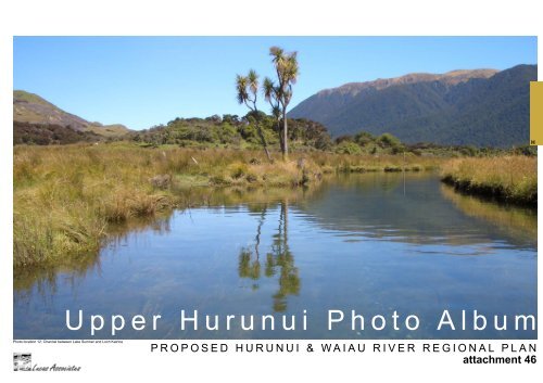
Upper Hurunui Photo Album
Upper Hurunui Photo Album
Upper Hurunui Photo Album

Create successful ePaper yourself
Turn your PDF publications into a flip-book with our unique Google optimized e-Paper software.
H<br />
<strong>Upper</strong> <strong>Hurunui</strong> <strong>Photo</strong> <strong>Album</strong><br />
<strong>Photo</strong> location 12: Channel between Lake Sumner and Loch Katrine<br />
P R O P O S E D H U R U N U I & W A I A U R I V E R R E G I O N A L P L A N<br />
attachment 46
H<br />
attachment 47a<br />
<strong>Hurunui</strong> River upper reaches - <strong>Photo</strong> locators
<strong>Upper</strong> North Branch<br />
North Branch<br />
H<br />
attachment 47b
H<br />
attachment 48a<br />
<strong>Hurunui</strong> River upper reaches - <strong>Photo</strong> locators
H<br />
attachment 48b
H<br />
<strong>Photo</strong>s <strong>Hurunui</strong> <strong>Upper</strong> North Branch to Lake Sumner<br />
P R O P O S E D H U R U N U I & W A I A U R I V E R R E G I O N A L P L A N<br />
*All photos are within ECAN’s proposed Zone C unless stated otherwise
Macs Knob<br />
Mount Longfellow<br />
H<br />
<strong>Photo</strong> location 1: <strong>Upper</strong> North Branch floodplain & river flats, coalescing fans and isolated mountain.<br />
Looking downstream toward Macs Knob and Mount Longfellow.<br />
Woolshed Ridge<br />
Crawford Range<br />
<strong>Photo</strong> location 2:<br />
Landslip Stream<br />
Flight photographs courtesy of Fish & Game<br />
<strong>Photo</strong> location 4:<br />
<strong>Upper</strong> North Branch delta<br />
landform.<br />
<strong>Photo</strong> location 4:<br />
<strong>Upper</strong> North Branch<br />
delta landform. Looking<br />
downstream toward<br />
Lake Sumner<br />
and Mount Longfellow.<br />
attachment 49<br />
<strong>Upper</strong> North Branch
H<br />
<strong>Photo</strong> location 3: <strong>Upper</strong> North Branch floodplain, fans & river flats and coalescing fans landforms. Looking upstream. Crawford Range.<br />
Flight photograph courtesy of Fish & Game<br />
attachment 50<br />
<strong>Upper</strong> North Branch
Macs Knob above<br />
Charleys Point<br />
<strong>Photo</strong> location 5:<br />
Lake Sumner looking<br />
up <strong>Upper</strong> North<br />
Branch. March 1985<br />
C<br />
r<br />
a<br />
w<br />
f<br />
o<br />
r<br />
d<br />
W<br />
o<br />
o<br />
l<br />
s<br />
h<br />
e<br />
d<br />
R<br />
i<br />
d<br />
g<br />
e<br />
N<br />
i<br />
g<br />
g<br />
e<br />
r<br />
h<br />
e<br />
a<br />
d<br />
H<br />
Evangeline Stream<br />
T<br />
h<br />
e<br />
B<br />
r<br />
o<br />
t<br />
h<br />
e<br />
r<br />
s<br />
attachment<br />
51<br />
Lake Sumner<br />
Conservation<br />
Park
H<br />
<strong>Photo</strong> location 61: Lake Sumner foreshore<br />
<strong>Photo</strong> location 62: Loch Katrine foreshore<br />
<strong>Photo</strong> location 62: Loch Katrine foreshore<br />
<strong>Photo</strong> location 62: Loch Katrine foreshore<br />
<strong>Photo</strong> location 62: Loch Katrine foreshore<br />
<strong>Photo</strong> location 62: Loch Katrine foreshore<br />
<strong>Photo</strong>s <strong>Hurunui</strong> North Basin Lakes<br />
P R O P O S E D H U R U N U I & W A I A U R I V E R R E G I O N A L P L A N<br />
*All photos are within ECAN’s proposed Zone C unless stated otherwise<br />
attachment 52
H<br />
<strong>Photo</strong> location 5: Three Mile Stream running out from Charleys Point into Lake Sumner<br />
<strong>Photo</strong> location 5: Charleys Point (Fan delta landform), mouth of Three Mile Stream<br />
150 years ago Julius Von Haast described the “thickly grassed riverbed” and “grassy rounded roches moutonnees”<br />
of the glaciated <strong>Hurunui</strong> lakes area. “The contrast between these grassy rounded hills and the high<br />
rugged mountains, covered to a height of 4,000 feet with dark beech forest, was very attractive.” At Sumner<br />
Lake “It was indeed a great pleasure to be able once more to enjoy nature in her pure virgin solitude. The<br />
quiet mirror of the lake, only disturbed here and there by ducks and other water birds; the dark forest, with the<br />
rugged rocky peaks above it, reflected in the lake, formed a landscape of such exquisite beauty that I was very<br />
unwilling to leave it.” (Lucas Associates,1995. p.16). <strong>Photo</strong>graph courtesty of Shaun Barnett, Fish and Game, 2007.<br />
Flight photographs courtesy of Fish & Game<br />
<strong>Photo</strong> location 7: Evangeline Stream<br />
<strong>Photo</strong> location 6: Lake Sumner looking upstream toward <strong>Upper</strong> North Branch delta attachment 53<br />
Lake Sumner
The Brothers - H13 Mountain range Nelson Tops - H19 Main divide Mount Longfellow - H13<br />
H<br />
<strong>Photo</strong> point 8: Lake Sumner<br />
Pass between Gabriel Stream and Jollie Brook<br />
Nelson Tops - H19 Main divide<br />
<strong>Photo</strong> point 8: Mount Longfellow, Lake Sumner<br />
attachment 54<br />
Lake Sumner Outlet
Nelson Tops - H19 Main divide<br />
H<br />
<strong>Photo</strong> point 8: Lake Sumner outlet.<br />
Pass between Gabriel Stream and Jollie Brook<br />
<strong>Photo</strong> point 8: Lake Sumner outlet to North Branch<br />
attachment 55<br />
Lake Sumner Outlet
H<br />
<strong>Photo</strong> location 10: The Brothers north face from Observation Point on Hope Kiwi Track below Lake Marion.<br />
<strong>Photo</strong> courtesy of Lesley Shand.<br />
<strong>Photo</strong> location 9: Lake Marion looking south toward Lake Sumner<br />
<strong>Photo</strong> location 12: Lake Sumner and Loch Katrine. Till and active floodplain and channel landform in<br />
foreground.<br />
<strong>Photo</strong> location 11: Macs Knob overlooking Lake Sumner and Loch Katrine<br />
Flight photographs courtesy of Fish & Game<br />
attachment 56<br />
Lake Marion and Lake Katrine
The Sisters - H7 Isolated mountain<br />
Hooligan Range on skyline<br />
Oronoko Range - H13 Mountain range<br />
<strong>Photo</strong> location 15: Lake Sheppard<br />
<strong>Photo</strong> location 14:<br />
Lake Mary<br />
H<br />
<strong>Photo</strong> location 13: Lake Sheppard and LakeTaylor separated by Conical Hill. Looking<br />
south toward The Lakes Station.<br />
Flight photographs courtesy of Fish & Game<br />
attachment 57<br />
Lake Sheppard, Lake Taylor and Lake Mary
H<br />
<strong>Photo</strong> point 16: South of The Brothers from The Sister.<br />
Oronoko Range - H13 Mountain range<br />
Conical Hill - H7 Isolated mountain.<br />
Woolshed Ridge - H13 Mountain range<br />
<strong>Photo</strong> point 17: Lake Sheppard from The Sisters.<br />
attachment 58<br />
‘Cultured Nature’
Nelson Tops - H19 Main divide.<br />
The Brothers - H13 Mountain range.<br />
Conical Hill - H7 Isolated mountain.<br />
H<br />
<strong>Photo</strong> point 18: Lake Taylor<br />
Nelson Tops - H19 Main divide.<br />
The Brothers - H13 Mountain range.<br />
Conical Hill - H7 Isolated mountain<br />
<strong>Photo</strong> point 18: Lake Taylor<br />
attachment 59<br />
Lake Taylor
Woolshed Ridge - H13<br />
Nelson Tops - H19 Main divide.<br />
The Brothers - H13 Mountain range<br />
Conical Hill - H7 Isolated mountain.<br />
The Sisters - H7 Isolated mountain<br />
H<br />
<strong>Photo</strong> point 19: Lake Taylor<br />
Conical Hill - H7 Isolated mountain.<br />
The Sisters - H7 Isolated mountain<br />
<strong>Photo</strong> point 19: Lake Taylor<br />
<strong>Photo</strong> point 20: Lake Taylor<br />
attachment 60<br />
Lake Taylor
Woolshed Ridge - H13 Mountain range<br />
Nelson Tops - H19 Main divide.<br />
The Brothers - H13 Mountain range<br />
Conical Hill - H7<br />
H<br />
<strong>Photo</strong> point 20: Lake Taylor<br />
attachment 61<br />
Lake Taylor
Woolshed Ridge - H13 Mountain range.<br />
Conical Hill - H7 Isolated mountain.<br />
H<br />
The Brothers - H13 Mountain range<br />
The Sisters - H7 Isolated mountain<br />
<strong>Photo</strong> point 21: Lake Taylor camp site/reserve.<br />
attachment 62<br />
Lake Taylor
Conical Hill - H7 Isolated mountain<br />
The Brothers - H13 Mountain range<br />
H<br />
<strong>Photo</strong> point 22: The Lakes looking north toward The Brothers. Raupo Pond is in the foreground below The Lakes homestead.<br />
Conical Hill - H7 Isolated mountain<br />
The Brothers - H13 Mountain range<br />
The Sisters - H7 Isolated mountain<br />
<strong>Photo</strong> point 22: The Lakes looking north toward The Brothers. Raupo Pond is in the foreground below The Lakes homestead.<br />
attachment 63<br />
The Lakes Station
Jollie Brook northeast cloud<br />
<strong>Photo</strong> point 23: Sisters Stream<br />
Conical Hill - H 7 Isolated mountain The Sisters - H7 Isolated mountain Little Sisters - H7 Isolated mountain<br />
<strong>Photo</strong> point 24: Sisters Stream<br />
attachment<br />
64<br />
Major<br />
River Valley L.T.<br />
Sisters Stream
H<br />
<strong>Photo</strong> point 63: Lake Sumner outlet to North Branch<br />
<strong>Photo</strong>s <strong>Hurunui</strong> North Branch<br />
PROPOSED HURUNUI & WAIAU RIVER REGIONAL PLAN<br />
attachment 65<br />
*All photos are within ECAN’s proposed Zone C unless stated otherwise
Haast recorded “Before the shore can be reached, at<br />
least ten old beaches, fully preserved and extending<br />
over the valley in a half circle, have to be descended.”<br />
Julius von Haast. 1859. A VISIT TO THE HURUNUI, in Alone in a Mountain World.<br />
H<br />
<strong>Photo</strong> location 25: Beach<br />
deposits at lake mouth.<br />
<strong>Photo</strong> courtesy of Lesley Shand<br />
Flight photographs courtesy of Fish & Game<br />
<strong>Photo</strong> location 8<br />
attachment 66<br />
Lake Sumner Outlet
Pass between Gabriel Stream and Jollie Brook<br />
Spur on true right of Jollie Brook<br />
Northeast cloud<br />
<strong>Photo</strong> point 26: North Branch eastern end of The Brothers, below Gabriels looking downstream across younger terraces and floodplain L.T. Kowhai line the river banks.<br />
H<br />
Spur on true right of Jollie Brook<br />
Northeast cloud<br />
<strong>Photo</strong> point 27: North Branch eastern end of The Brothers, below Gabriels looking downstream across younger terraces and floodplain L.T.<br />
attachment 67<br />
North Branch eastern end of The Brothers (H1 + H2 L.T.)
Mount Longfellow - H13 Mountain range.<br />
H<br />
<strong>Photo</strong> point 29: North Branch younger terraces and floodplain.<br />
<strong>Photo</strong> point 28: Mount Longfellow - H13 Mountain range.<br />
attachment 68<br />
North Branch eastern end of The Brothers (H1 + H2 L.T.)
H<br />
<strong>Photo</strong> point 30: North Branch looking downstream across younger terraces and floodplain L.T.<br />
attachment 69<br />
North Branch eastern end of The Brothers (H1 Major river, valley fill & H2 Glacial and fluvial valley floor L.T.)
Nelson Tops - H19 Main divide<br />
Mount Longfellow - H13<br />
H<br />
<strong>Photo</strong> point 31:<br />
Lake Sumner<br />
Road<br />
Little Sisters - H7 Isolated Mountain.<br />
Mount Longfellow - H13 Mountain Range<br />
<strong>Photo</strong> point 32: Lake Sumner Road<br />
attachment 70<br />
Major River Valley L.T. below Sisters Stream
Jollie Brook - H13 Mountain range<br />
Little Sisters - H7 Isolated mountain<br />
H<br />
<strong>Photo</strong> location 33: Jollie Brook confluence with North Branch looking north toward Little Sisters.<br />
Flight photographs courtesy of Fish & Game<br />
<strong>Photo</strong> location 33: Jollie<br />
Brook confluence looking<br />
upstream.<br />
attachment 71<br />
Jollie Brook
Jollie Brook<br />
H<br />
<strong>Photo</strong> point 35: Looking upstream <strong>Hurunui</strong> River. Lake Sumner Road on true right of river.<br />
Jollie Brook<br />
<strong>Photo</strong> point 36: Looking north toward Jollie Brook. ‘Cotton wool’ cloud on true right of Jollie Brook. <strong>Hurunui</strong> River to right of telegraph lines.<br />
attachment 72<br />
<strong>Hurunui</strong> River terraces below Jollie Brook
H<br />
<strong>Photo</strong> point 37: Bedrock channel looking toward South<br />
Branch confluence<br />
<strong>Photo</strong> point 37: North Branch above South Branch confluence looking upstream toward Jollie Brook & Mt Longfellow<br />
<strong>Photo</strong> point 37: Bedrock channel<br />
attachment 73<br />
North Branch above<br />
South Branch confluence<br />
(Incised channel cut into bedrock<br />
with remnant terraces L.T.)
H<br />
<strong>Photo</strong> location 38:<br />
Dozy Stream confluence to<br />
North Branch below South<br />
Branch confluence.<br />
Flight photograph courtesy of Fish & Game<br />
<strong>Photo</strong> point 39: From bottom<br />
end of Maori Gully looking<br />
upstream.<br />
attachment 74<br />
Maori Gully (Incised channel cut into<br />
bedrock with remnant terraces L.T.)
Surveyors Stream<br />
<strong>Hurunui</strong> Range<br />
H<br />
<strong>Photo</strong> location 40: Maori Gully looking downstream toward Surveyors<br />
Stream and terraces. Lake Sumner Road on right<br />
<strong>Photo</strong> location 41: North Branch intermediate and low terraces<br />
southeast of Mt Miza below Maori Gully. Looking<br />
downstream toward Dampier Knob.<br />
<strong>Photo</strong> location 42: Looking downstream toward Beau Saddle.<br />
Flight photographs courtesy of Fish & Game<br />
attachment 75<br />
North Branch Maori Gully to below Beau Saddle (Low to high terraces L.T’s)
H<br />
<strong>Photo</strong> location 44: Angler - Mandamus confluence<br />
Zone B<br />
<strong>Photo</strong> location 43: Downstream of Glenrae confluence to North<br />
Branch looking toward Dampier Knob.<br />
Zone B<br />
<strong>Photo</strong> location 44: Mandamus confluence.<br />
Zone B<br />
Flight photographs courtesy of Fish & Game<br />
attachment 76<br />
Mandamus confluence to <strong>Hurunui</strong>
H<br />
<strong>Photo</strong> location 44:<br />
Mandamus<br />
Zone B<br />
attachment<br />
77<br />
<strong>Hurunui</strong> River &<br />
Mandamus<br />
July 1982
South Branch toward Operation Ark<br />
H<br />
<strong>Photo</strong> location 46: South Branch north of Mason Stream<br />
confluence looking upstream. Flight photograph courtesy of<br />
Fish & Game.<br />
P h o t o s H u r u n u i S o u t h B r a n c h<br />
P R O P O S E D H U R U N U I & W A I A U R I V E R R E G I O N A L P L A N<br />
attachment 78<br />
*All photos are within ECAN’s proposed Zone C unless stated otherwise
Bell Knoll - H7 Isolated Hill<br />
<strong>Photo</strong> location<br />
45: Lake Mason<br />
(south) outlet into<br />
Mason Stream<br />
which drains into<br />
South Branch.<br />
Bell Knoll in centre<br />
background.<br />
H<br />
<strong>Photo</strong> location 45: Lake Mason and Lake Mason Hut.<br />
Looking south toward South Branch. Bell Knoll and Island<br />
Hills in centre background.<br />
Flight photographs courtesy of Fish & Game<br />
<strong>Photo</strong> location 45: Lake Mason (north).<br />
Looking toward the northern end of<br />
Woolshed Ridge.<br />
attachment 79<br />
Lake Mason
Island Hills - H13 Mountain range<br />
Bell Knoll - H7 Isolated mountain<br />
H<br />
<strong>Photo</strong> location 47: South Branch basin<br />
<strong>Photo</strong>graphy courtesy of Lesley Shand (Autumn 2007)<br />
attachment 80
Studleigh Range - H13 Mountain range<br />
Looking up stream toward Stony Stream<br />
H<br />
attachment 81<br />
South Branch Basin (Floodplains, fans and river flats L.T.)
Crawford Range - H19 Main divide<br />
Bell Knoll - H7 Isolated mountain<br />
Nelson Tops - H19 Main divide<br />
Woolshed Ridge - H13 Mountain range<br />
H<br />
<strong>Photo</strong> location 48<br />
Glacial depositional landforms: Moraine<br />
Fluvial depositional landforms: Coalescing fans, high terraces & fans<br />
<strong>Photo</strong>graphy courtesy of Lesley Shand (1983)<br />
attachment 82<br />
Red Tussock south of Bell Knoll
Crawford Range - H19 Main divide.<br />
Mason Stream public access to South Branch<br />
H<br />
<strong>Photo</strong> poiint 49: South Branch river bed<br />
attachment 83<br />
South Branch Basin (Floodplains, fans and river flats L.T.)
Studleigh Range - H13 Mountain range Bell Knoll - H7 Isolated mountain. Crawford Range - H19 Main divide.<br />
H<br />
<strong>Photo</strong> point 49: South Branch basin looking upstream. Moraine, High terraces and Isolated Mountain (Bell Knoll) landforms in midground.<br />
Raoulia hookeri<br />
Raoulia haastii<br />
Scleranthus uniflorus<br />
Raoulia subsericea<br />
<strong>Photo</strong> point 49: Flora of the fluvial channelled island in the South Branch.<br />
attachment 84<br />
South Branch Basin (Floodplains, fans and river flats L.T.)
Studleigh Range - H13 Mountain range<br />
Crawford Range - H19 Main divide.<br />
Mason Stream public access to South Branch<br />
H<br />
<strong>Photo</strong> point 50: South Branch basin looking upstream.<br />
Muehlenbeckia axilliaris<br />
Raoulia subsericea<br />
<strong>Photo</strong> point 49: Flora of the fluvial channelled island in the South Branch (see above photo)<br />
Raoulia subsericea<br />
Aristotelia fruticosa<br />
attachment 85<br />
South Branch Basin (Floodplains, fans and river flats)
Puketeraki Range - H9<br />
Dampier Range - H13 Mountain. range.<br />
Island Hills - H13 Mountain range<br />
Moraine<br />
H<br />
<strong>Photo</strong> point 50: South Branch basin looking downstream.<br />
Raoulia subsericea & Epilobium brunnescens Raoulia hookeri Epilobium brunnescens<br />
<strong>Photo</strong> point 49: Flora of the fluvial channelled island in the South Branch.<br />
Raoulia tenuiculusis with<br />
Hydrocotyle novae-zelandiae growing out of it<br />
attachment 86
Studleigh Range - H13 Mountain range Bell Knoll - H7 Isolated mountain. Crawford Range - H19 Main divide.<br />
H<br />
<strong>Photo</strong> point 50: South Branch basin looking upstream. Fluvial channelled island in foreground hosts an array of indigenous flora (see below photos).<br />
Raoulia haastii Raoulia hookeri Epilobium brunnescens Raoulia subsericea Raoulia hookeri<br />
Muehlenbeckia axilliaris Epilobium melanocaulin<br />
Raoulia tenuiculusis<br />
<strong>Photo</strong> point 49: Flora of the fluvial channelled island in the South Branch (see above photo)<br />
attachment 87<br />
South Branch Basin (Floodplains, fans and river flats)
Island Hills - H13 Mountain range<br />
Studleigh Range - H13 Mountain range.<br />
Bell Knoll - H7 Isolated mountain.<br />
Crawford Range - H19 Main Divide<br />
H<br />
Moraine - Glacial depositional landform<br />
<strong>Photo</strong> point 50: South Branch basin<br />
looking upstream<br />
Homestead Stream, between high<br />
terraces & fans (left) and moraine (right)<br />
Dampier Range - H13 Mountain range<br />
Island Hills - H13 Mountain range<br />
Moraine - Glacial depositional landform<br />
<strong>Photo</strong> point 50: South Branch basin looking downstream<br />
attachment 88<br />
South Branch Basin (Glacial and fluvial valley floor L.T.)
Island Hills - H13 Mountain range<br />
Studleigh Range - H13<br />
Crawford Range - H19 Main divide<br />
<strong>Photo</strong> point 51: South Branch basin looking upstream<br />
H<br />
<strong>Photo</strong> point 51: Flax Stream track<br />
<strong>Photo</strong> point 51: Dampier Range - H13 Mountain range.<br />
attachment 89<br />
South Branch Basin (Glacial and fluvial valley floor L.T.)
H<br />
<strong>Photo</strong> point 52: Distinctive change in vegetation from Kanuka & Manuka on the north side to Beech forest on the south side of Woolshed Ridge.<br />
attachment 90<br />
Flax Stream Track
H<br />
<strong>Photo</strong> location 53: South Branch looking downstream toward North<br />
Esk confluence with South Branch.<br />
<strong>Photo</strong> location 53: South Branch looking downstream toward North<br />
Esk confluence with South Branch.<br />
<strong>Photo</strong> location 53: South Branch looking downstream toward North<br />
Esk confluence with South Branch.<br />
Flight photographs courtesy of Fish & Game<br />
attachment 91<br />
South Branch Basin (Floodplains, fans and river flats L.T.)
Studleigh Range - H13 Mountain range Crawford Range - H19 Main divide Oronoko Range - H13 Mountain range<br />
H<br />
<strong>Photo</strong> location 54: South Branch basin from above gorge looking<br />
upstream toward Bell Knoll, Studleigh and Crawford Ranges.<br />
<strong>Photo</strong> location 55: Looking upstream toward South Branch basin. Green remnant terrace in foreground.<br />
<strong>Photo</strong>graphy courtesy of Lesley Shand (Autumn 2007)<br />
Flight photographs courtesy of Fish & Game<br />
attachment 92<br />
South Branch Gorge
H<br />
<strong>Photo</strong> location 56: South Branch gorge looking downstream.<br />
<strong>Photo</strong> location 56: South Branch gorge.<br />
Flight photographs courtesy of Fish & Game<br />
attachment 93<br />
South Branch
Remnant Terraces<br />
H<br />
<strong>Photo</strong> location 57: South Branch gorge looking downstream toward Esk<br />
Head Station. Hooligan Range in background.<br />
<strong>Photo</strong> location 56: South Branch gorge looking upstream<br />
<strong>Photo</strong> location 58: South Branch gorge looking downstream toward<br />
Hooligan Range. Esk Head Station woolshed on terrace in centre of<br />
photograph.<br />
Flight photographs courtesy of Fish & Game<br />
attachment 94<br />
South Branch Gorge
H<br />
<strong>Photo</strong> location 59: South Branch gorge looking downstream toward Hooligan Range and South Branch confluence.<br />
Flight photographs courtesy of Fish & Game<br />
attachment 95<br />
South Branch Gorge (Remnant terraces & floodplain L.T.)
Dampier Range - H13 Mountain range<br />
Oronoko Range - H13 Mountain range<br />
H<br />
Oronoko Range - H13<br />
South Branch confluence<br />
<strong>Photo</strong> point 60: South Branch<br />
looking upstream (‘rock gate’<br />
of Oronoko Range)<br />
<strong>Photo</strong> point 60: South Branch looking downstream toward mainstem of the <strong>Hurunui</strong> River<br />
<strong>Photo</strong> courtesy of Lesley Shand.<br />
attachment 96<br />
At South Branch confluence to Mainstem (Remnant terraces & floodplain L.T.)
landscape architects<br />
‘Marokapara’<br />
351 Manchester Street<br />
Christchurch<br />
Aotearoa New Zealand<br />
Phone: (03) 365-0789 Fax: (03) 365-0798<br />
theteam@lucas-associates.co.nz<br />
www.lucas-associates.co.nz