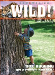
CAN WE SAVE THE WOLF? - New Mexico Wilderness Alliance
CAN WE SAVE THE WOLF? - New Mexico Wilderness Alliance
CAN WE SAVE THE WOLF? - New Mexico Wilderness Alliance

You also want an ePaper? Increase the reach of your titles
YUMPU automatically turns print PDFs into web optimized ePapers that Google loves.
d i s c o v e r <strong>New</strong><strong>Mexico</strong><br />
<strong>New</strong> <strong>Mexico</strong>’s National Grasslands<br />
By Michael Scialdone<br />
The Great Plains of the United States<br />
begin east of the Sangre de Cristo<br />
Mountains. Many times plowed under<br />
and overgrazed, this neglected grassland<br />
ecosystem has probably seen<br />
more change and damage than any<br />
other. Their name is partly a misnomer.<br />
They are indeed<br />
‘great’, but they are<br />
hardly ‘plain’, a term<br />
bestowed upon them<br />
by those who think in<br />
terms of topography<br />
vs. flatness and not<br />
in terms of ecological<br />
wonder. For the<br />
complex interactions<br />
of the plants and<br />
creatures of a wild<br />
or restored grassland<br />
are awe-inspiring.<br />
Within the northeast<br />
portion of <strong>New</strong><br />
<strong>Mexico</strong> are two<br />
National Grasslands<br />
(NG) that most <strong>New</strong><br />
Mexicans know<br />
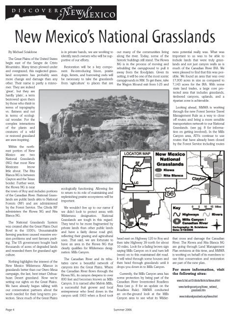
little about. The Rita<br />
Blanca NG is between<br />
Clayton and the Texas<br />
border. Further west,<br />
the Kiowa NG is near<br />
the town of Roy and includes portions<br />
of the Canadian River. National Grasslands<br />
are public lands akin to National<br />
Forests (NF) and are administered<br />
by the Forest Service. The Cibola NF<br />
administers the Kiowa NG and Rita<br />
Blanca NG.<br />
The National Grasslands System<br />
was created after the Great Plains Dust<br />
Bowl in the 1930’s. Unsustainable<br />
farming practices caused massive erosion<br />
problems and sent farmers packing.<br />
The US government bought back<br />
thousands of acres of degraded lands<br />
and reseeded them for grassland agriculture.<br />
Nothing highlights the interest of the<br />
<strong>New</strong> <strong>Mexico</strong> <strong>Wilderness</strong> <strong>Alliance</strong> in<br />
grasslands better than our Otero Mesa<br />
campaign, the last, best intact Chihuahuan<br />
Desert grassland. Now we’re<br />
setting our sights on the Great Plains.<br />
We have already begun talking with<br />
our conservation partners about the<br />
work needed for their long-term protection.<br />
Since much of the Great Plains<br />
is in private hands, we are working to<br />
identify ranch owners who will be supportive<br />
of our efforts.<br />
Restoration will be a key component.<br />
Re-introducing bison, prairie<br />
dogs, ferrets, and burrowing owls will<br />
be necessary to take the grasslands<br />
from ‘agriculture’ to places that are<br />
ecologically functioning. Allowing fire<br />
to return to its role of maintaining and<br />
replenishing prairie ecosystems will be<br />
important.<br />
We wouldn’t live up to our name if<br />
we didn’t look to protect areas with<br />
<strong>Wilderness</strong> designation. National<br />
Grasslands are tough in this regard.<br />
They tend to be more fragmented by<br />
private lands than other public lands<br />
and have a fairly dense road grid,<br />
reflecting their grazing and agricultural<br />
uses. That said, we are fortunate to<br />
have an area in the Kiowa NG that<br />
clearly qualifies for <strong>Wilderness</strong> designation:<br />
Mills Canyon.<br />
The Canadian River and its tributaries<br />
carve a beautiful network of<br />
canyons into the Great Plains. Where<br />
the Canadian River flows through the<br />
Kiowa NG, its canyon deepens to over<br />
800 feet and becomes known as Mills<br />
Canyon. It is named after Melvin Mills,<br />
a successful fruit grower and local<br />
entrepreneur who lived down in the<br />
canyon until 1903 when a flood took<br />
out many of the communities living<br />
along the river. Today, some of the<br />
historic buildings still stand. The Kiowa<br />
NG is in the process of moving and<br />
rebuilding the campground to pull it<br />
away from the floodplain. Given its<br />
setting, it will be one of the most scenic<br />
campgrounds in NM. To get there, take<br />
the Wagon Mound exit from I-25 and<br />
head east on Highway 120 to Roy and<br />
then take Highway 39 north for about<br />
10 miles. Look for a fading brown sign<br />
saying Mills Canyon on it and turn left<br />
(west) on to this maintained dirt road.<br />
It will wind through some houses and<br />
then head through grasslands until it<br />
drops you down in to Mills Canyon.<br />
Currently, the Mills Canyon area has<br />
some protection by being part of the<br />
Canadian River Inventoried Roadless<br />
Area (see p. 8 for an update on the<br />
Roadless Rule). NMWA conducted<br />
an on-the-ground look at the Mills<br />
Canyon area to see what its <strong>Wilderness</strong><br />
potential really was. What was<br />
important to us was to be able to<br />
include lands that were truly grasslands<br />
and not just canyon walls as is<br />
much of the Canadian River IRA. We<br />
were pleased to find that this was possible.<br />
We found an area that was over<br />
17,000 acres in size as compared to<br />
7,143 acres for the IRA. With some<br />
state land trades, a large core protected<br />
area that includes grasslands,<br />
timbered canyons, uplands, and a<br />
riparian zone is achievable.<br />
Looking ahead, NMWA is working<br />
through the new Forest Service Travel<br />
Management Rule as a way to close<br />
off routes and bring a more sensible<br />
transportation network to our National<br />
Grasslands. (see pg. 8 for information<br />
on getting involved). In the Mills<br />
Canyon area, ATVs continue to use<br />
routes that have already been closed<br />
by the Forest Service including routes<br />
that cross and damage the Canadian<br />
River. The Kiowa and Rita Blanca NG<br />
are going through Land Management<br />
Plan revisions at this time, and NMWA<br />
is working on behalf of its members to<br />
see that conservation and restoration<br />
are part of the new plan.<br />
For more information, visit<br />
the following sites:<br />
www.fs.fed.us/r3/cibola/districts/kiowa.shtml<br />
www.hardingcounty.org/kiowa_national_<br />
grasslands.htm<br />
www.trailsandgrasslands.org/kiowa.html<br />
Page 4 Summer 2006