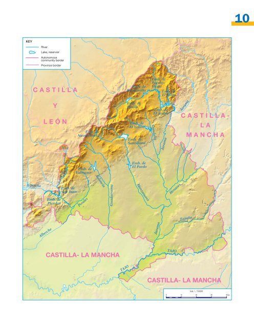
The hydrography of Madrid Characteristics of the rivers in the region Almost all of the rivers that flow through the Madrid region are tributaries of the Tajo or of other rivers that flow into it. Apart from the Tajo, our rivers have very similar characteristics: • They are short: none is over 190 km long. • They have little water, due to the little rain the region receives. • The amount of water varies depending on the season, as the rainfall is variable during the year. The rivers in Madrid, except the Tajo, are short and have little water, the amount of which varies depending on the season. The rivers in Madrid The Tajo is the most important of the rivers that pass through our region. Its source is in the Montes Universales, in the Sistema Ibérico, it crosses four autonomous communities: Aragon, Castilla-La Mancha, Madrid and Extremadura. It flows into the Atlantic Ocean, near Lisbon. Despite its great length (1008km) it doesn’t have much water. The main tributaries of the Tajo are: • The Guadarrama, its source lies in the Fuenfría pass and also flows through Collado Villalba. Its main tributary is the river Aulencia. • The Alberche, its source lies in the Sierra de Gredos and passes through the towns of San Martin de Valdeiglesias and Pelayos de la Presa. Its main tributaries are the Cofio and Perales rivers. • The Jarama, its source lies in the province of Guadalajara, it is the river that covers more kilometres of Madrilenian soil. It flows into the Tajo after passing the town of Aranjuez. Its abundant reservoirs supply most of the region’s water. Tributaries of the Jarama are: – The Lozoya and the Manzanares, their sources lie in the Sierra de Gredos. – The Guadalix, its source lies in the Sierra de Morcuera. – The Henares and the Tajuña: their sources are in Castilla-La Mancha. The main rivers in Madrid are the Tajo, the Guadarrama, the Alberche and the Jarama. Questions 1 Look at the map and answer: a) Which river can be found to the furthest point west of the region? b) And to the east? c) Which river is closest to the Humosa high plateau? d) With the help of the map, indicate which rivers pass through these towns and cities: Madrid, Aranjuez, Collado Villalba and Buitrago.
10 KEY River Lake, reservoir Autonomous community border Province border CASTILLA Emb. de Riosequillo Emb. de Puentes Viejas Emb. de El Villar Y LEÓN Emb. de Navacerrada Lozoya Emb. de Pinilla Emb. de El Vellón Emb. de Santillana Guadalix Emb. de El Atazar Jarama Jarama CASTILLA- LA MANCHA Cofio Emb. de Valmayor Emb. de El Pardo Aulencia Alberche Emb. de Picadas Emb. de San Juan Perales Guadarrama Manzanares Henares Tajuña Alberche Jarama CASTILLA- LA MANCHA TAJO TAJO CASTILLA- LA MANCHA Scale: 1 / 750000 0 10 20 30 40 km