Storms, Floods, and the Science of Atmospheric Rivers
Storms, Floods, and the Science of Atmospheric Rivers
Storms, Floods, and the Science of Atmospheric Rivers

You also want an ePaper? Increase the reach of your titles
YUMPU automatically turns print PDFs into web optimized ePapers that Google loves.
Eos, Vol. 92, No. 32, 9 August 2011<br />
EOS, Transactions, American Geophysical Union<br />
Volume 92 number 32<br />
9 AUGUST 2011<br />
pages 265–272<br />
<strong>Storms</strong>, <strong>Floods</strong>, <strong>and</strong> <strong>the</strong> <strong>Science</strong><br />
<strong>of</strong> <strong>Atmospheric</strong> <strong>Rivers</strong><br />
PAGES 265–266<br />
Imagine a stream <strong>of</strong> water thous<strong>and</strong>s <strong>of</strong><br />
kilometers long <strong>and</strong> as wide as <strong>the</strong> distance<br />
between New York City <strong>and</strong> Washington,<br />
D. C., flowing toward you at 30 miles per<br />
hour. No, this is not some hypo<strong>the</strong>tical physics<br />
problem—it is a real river, carrying more<br />
water than 7–15 Mississippi <strong>Rivers</strong> combined.<br />
But it is not on l<strong>and</strong>. It’s a river <strong>of</strong> water<br />
vapor in <strong>the</strong> atmosphere.<br />
<strong>Atmospheric</strong> rivers (ARs) are narrow corridors<br />
<strong>of</strong> water vapor transport in <strong>the</strong> lower<br />
atmosphere that traverse long swaths <strong>of</strong> <strong>the</strong><br />
Earth’s surface as <strong>the</strong>y bind toge<strong>the</strong>r <strong>the</strong><br />
atmospheric water cycle (Figure 1). The characteristic<br />
(indeed defining) dimensions <strong>of</strong><br />
<strong>the</strong>se ARs are (1) integrated water vapor<br />
(IWV) concentrations such that if all <strong>the</strong><br />
vapor in <strong>the</strong> atmospheric column were condensed<br />
into liquid water, <strong>the</strong> result would be<br />
a layer 2 or more centimeters thick; (2) wind<br />
speeds <strong>of</strong> greater than 12.5 meters per second<br />
in <strong>the</strong> lowest 2 kilometers; <strong>and</strong> (3) a shape<br />
that is long <strong>and</strong> narrow, no more than 400–<br />
500 kilometers wide, <strong>and</strong> extending for thous<strong>and</strong>s<br />
<strong>of</strong> kilometers, sometimes across entire<br />
ocean basins.<br />
Research during <strong>the</strong> past decade has documented<br />
<strong>the</strong> importance <strong>of</strong> ARs to <strong>the</strong> overall<br />
workings <strong>of</strong> <strong>the</strong> midlatitude global water<br />
cycle. Moreover, <strong>the</strong>ir presence <strong>and</strong> characteristics<br />
are at <strong>the</strong> root <strong>of</strong> <strong>the</strong> most extreme<br />
precipitation <strong>and</strong> flooding in areas where<br />
<strong>the</strong>se features encounter mountains. At <strong>the</strong><br />
same time, ARs make important contributions<br />
to how much snow <strong>and</strong> water will be<br />
available in <strong>the</strong>se regions. Thus, underst<strong>and</strong>ing<br />
<strong>the</strong>ir behavior may be <strong>the</strong> key to determining<br />
how changing climate patterns influence<br />
extreme precipitation <strong>and</strong> floods. Overall,<br />
<strong>the</strong> need to underst<strong>and</strong> ARs opens up a<br />
new set <strong>of</strong> gr<strong>and</strong> challenges for water cycle,<br />
water supply, <strong>and</strong> flood prediction science.<br />
Observations <strong>of</strong> <strong>Atmospheric</strong> <strong>Rivers</strong><br />
Zhu <strong>and</strong> Newell [1998] helped coin<br />
<strong>the</strong> term “atmospheric river” based on its<br />
narrow ness <strong>and</strong> importance to <strong>the</strong> water<br />
By F. M. Ralph <strong>and</strong> M. D. Dettinger<br />
cycle. They found that at any given time, an<br />
average <strong>of</strong> more than 90% <strong>of</strong> <strong>the</strong> total poleward<br />
atmospheric water vapor transport<br />
through <strong>the</strong> middle latitudes is concentrated<br />
in four to five narrow regions that total less<br />
than 10% <strong>of</strong> <strong>the</strong> circumference <strong>of</strong> <strong>the</strong> Earth<br />
at that latitude. These features are generally<br />
located in <strong>the</strong> warm sectors <strong>of</strong> midlatitude<br />
cyclones, ahead <strong>of</strong> cold fronts. They<br />
continually form, move, <strong>and</strong> evolve with<br />
storms in <strong>the</strong> midlatitude storm tracks, sometimes<br />
drawing tropical water vapor <strong>and</strong> heat<br />
directly into <strong>the</strong> middle latitudes [e.g., Stohl<br />
et al., 2008; Ralph et al., 2011].<br />
Since <strong>the</strong> seminal work <strong>of</strong> Zhu <strong>and</strong> Newell<br />
[1998], <strong>the</strong> prevalence <strong>and</strong> role <strong>of</strong> ARs in <strong>the</strong><br />
water cycle <strong>and</strong> in continental wea<strong>the</strong>r have<br />
become ever more clear, partly because <strong>of</strong><br />
<strong>the</strong> advent <strong>of</strong> microwave remote sensing<br />
from polar- orbiting satellites, especially <strong>the</strong><br />
Special Sensor Microwave Imager (SSM/I),<br />
which provides frequent global measurements<br />
<strong>of</strong> IWV over <strong>the</strong> Earth’s oceans, measurements<br />
that previously were available<br />
above only <strong>the</strong> relatively few sites where<br />
wea<strong>the</strong>r balloons <strong>and</strong> related instruments<br />
were deployed. The imager works very well<br />
over oceans <strong>and</strong>, since its spatiotemporal<br />
coverage became adequate in about 1998,<br />
has focused growing attention on ARs (see<br />
Figure 1a) in ways that previous water vapor<br />
data could not.<br />
In <strong>the</strong> years since <strong>the</strong>n, a growing number<br />
<strong>of</strong> field experiments <strong>and</strong> related studies have<br />
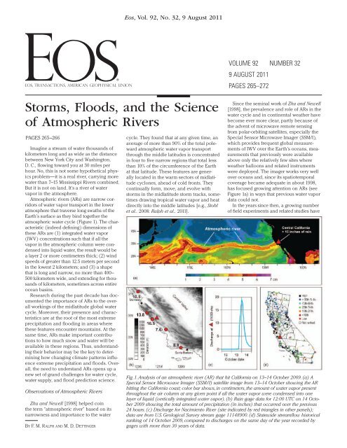
Fig. 1. Analysis <strong>of</strong> an atmospheric river (AR) that hit California on 13–14 October 2009. (a) A<br />
Special Sensor Microwave Imager (SSM/I) satellite image from 13–14 October showing <strong>the</strong> AR<br />
hitting <strong>the</strong> California coast; color bar shows, in centimeters, <strong>the</strong> amount <strong>of</strong> water vapor present<br />
throughout <strong>the</strong> air column at any given point if all <strong>the</strong> water vapor were condensed into one<br />
layer <strong>of</strong> liquid (vertically integrated water vapor). (b) Rain gage data for 12:00 UTC on 14 October<br />
2009 showing <strong>the</strong> total amount <strong>of</strong> precipitation (in inches) that occurred over <strong>the</strong> previous<br />
24 hours. (c) Discharge for Nacimiento River (site indicated by red triangles in o<strong>the</strong>r panels);<br />
data are from U.S. Geological Survey stream gage 11148900. (d) Statewide streamflow historical<br />
ranking <strong>of</strong> 14 October 2009, compared to discharges on <strong>the</strong> same day <strong>of</strong> <strong>the</strong> year recorded by<br />
gages with more than 30 years <strong>of</strong> data.
explored <strong>the</strong> physical characteristics <strong>and</strong><br />
effects <strong>of</strong> ARs, focused mostly over <strong>the</strong> eastern<br />
Pacific Ocean <strong>and</strong> western North America<br />
(a bibliography <strong>of</strong> AR- related research<br />
papers <strong>and</strong> many additional resources on<br />
ARs are available at http://www.esrl.noaa<br />
.gov/psd/ atmrivers/). Research aircraft observations<br />
in two ARs above <strong>the</strong> eastern North<br />
Pacific in <strong>the</strong> winters <strong>of</strong> 1998 <strong>and</strong> 2005 [Ralph<br />
et al., 2005, 2011] showed that <strong>the</strong>y transported<br />
water vapor at about 13–26 cubic<br />
kilometers per day, a rate equivalent to 7.5–<br />
15 times <strong>the</strong> average daily discharge <strong>of</strong> <strong>the</strong><br />
Mississippi River into <strong>the</strong> Gulf <strong>of</strong> Mexico.<br />
A Closer Look at Rainfall<br />
From <strong>Atmospheric</strong> <strong>Rivers</strong><br />
Because ARs transport so much water<br />
vapor, <strong>the</strong>y represent a significant source <strong>of</strong><br />
precipitation to coastal regions. For example,<br />
a recent numerical model study [Smith<br />
et al., 2010] estimated that roughly 20–40%<br />
<strong>of</strong> <strong>the</strong> water vapor transported ashore by<br />
an AR crossing over nor<strong>the</strong>rn California<br />
was rained out <strong>the</strong>re. This rainout happens<br />
because when ARs make l<strong>and</strong>fall on <strong>the</strong><br />
West Coast <strong>of</strong> North America (as well as on<br />
o<strong>the</strong>r continents [e.g., Stohl et al., 2008]),<br />
<strong>the</strong>y are forced up <strong>and</strong> over coastal mountains,<br />
where <strong>the</strong>y cool <strong>and</strong> condense large<br />
parts <strong>of</strong> <strong>the</strong>ir heavy burden <strong>of</strong> vapor [e.g.,<br />
Neiman et al., 2008; Leung <strong>and</strong> Qian, 2009].<br />
In a recent example, an AR event produced<br />
more than 410 millimeters (16.5<br />
inches) <strong>of</strong> rainfall at one site in coastal California<br />
on 14–15 October 2009 (Figure 1).<br />
This particular AR had a very long fetch,<br />
spanning most <strong>of</strong> <strong>the</strong> North Pacific (Figure<br />
1a), <strong>and</strong> upon making l<strong>and</strong>fall deposited<br />
more than 200 millimeters <strong>of</strong> rain along<br />
a swath <strong>of</strong> coastal California several hundred<br />
kilometers wide (Figure 1b). Significant<br />
streamflow resulted, including a 5- meter rise<br />
in water level on <strong>the</strong> Nacimiento River over<br />
12 hours (Figure 1c), with <strong>the</strong> flows cresting<br />
at 525 cubic meters per second (18,600<br />
cubic feet per second). Record- high daily<br />
streamflows (for that date <strong>of</strong> year) were also<br />
observed at many o<strong>the</strong>r stations in central<br />
<strong>and</strong> nor<strong>the</strong>rn California (Figure 1d).<br />
It should be noted that this peak flow <strong>of</strong><br />
<strong>the</strong> Nacimiento River exceeded <strong>the</strong> annual<br />
peak flow in 28 <strong>of</strong> <strong>the</strong> past 40 years <strong>and</strong> did<br />
so in spite <strong>of</strong> <strong>the</strong> very dry conditions preceding<br />
this storm. This event exhibits key attributes<br />
found in o<strong>the</strong>r extreme ARs [e.g., Neiman<br />
et al., 2008; Ralph et al., 2011], including<br />
very large IWV values, indications <strong>of</strong> entrainment<br />
<strong>of</strong> tropical water vapor (from <strong>the</strong> western<br />
Pacific in this case, incorporating remnants<br />
<strong>of</strong> a western Pacific typhoon), <strong>and</strong> <strong>the</strong><br />
fact that it stalled over parts <strong>of</strong> <strong>the</strong> West Coast<br />
in ways that amplified <strong>the</strong> storm’s impacts.<br />
Historically, AR storms have been <strong>the</strong><br />
sources <strong>of</strong> many (<strong>and</strong>, in some areas, most)<br />
floods in <strong>the</strong> Pacific coast states. For example,<br />
all storms that resulted in declared<br />
flood conditions on <strong>the</strong> Russian River <strong>of</strong> central<br />
California from 1998 to 2005 arose from<br />
Eos, Vol. 92, No. 32, 9 August 2011<br />
l<strong>and</strong>falling ARs [Ralph et al., 2006]; similar<br />
relations appear to exist between ARs <strong>and</strong><br />
major flooding in most rivers from California<br />
to Washington State. In addition to <strong>the</strong>ir<br />
roles as producers <strong>of</strong> extreme storms <strong>and</strong><br />
flood hazards, it is important to mention that<br />
ARs also are major contributors to western<br />
(especially California) water supplies [Dettinger<br />
et al., 2011; Guan et al., 2010]. Indeed,<br />
<strong>the</strong> half dozen or so ARs per year that make<br />
l<strong>and</strong>fall in California have contributed an<br />
average <strong>of</strong> one third to one half <strong>of</strong> all <strong>the</strong><br />
state’s precipitation, with a single typical AR<br />
storm yielding perhaps 2.5–5 cubic kilometers<br />
<strong>of</strong> precipitation, or roughly 10% <strong>of</strong> <strong>the</strong><br />
annual average run<strong>of</strong>f <strong>of</strong> <strong>the</strong> entire Sacramento<br />
River basin.<br />
Studies <strong>of</strong> <strong>Atmospheric</strong> <strong>Rivers</strong><br />
From <strong>the</strong> West Coast<br />
The dual roles <strong>of</strong> ARs as hazards <strong>and</strong><br />
water resources in many coastal regions may<br />
become a more pressing issue under anthropogenic<br />
climate change, which may alter<br />
both hazardous <strong>and</strong> productive aspects <strong>of</strong><br />
<strong>the</strong>se storms [Dettinger, 2011]. For example, in<br />
view <strong>of</strong> <strong>the</strong> havoc that <strong>the</strong>se storms wreak on<br />
<strong>the</strong> Pacific coast states, underst<strong>and</strong>ing <strong>and</strong><br />
predicting <strong>the</strong>m on time scales from days to<br />
decades, <strong>and</strong> at spatial scales from mountain<br />
ranges like <strong>the</strong> Sierra Nevadas <strong>and</strong> Cascades<br />
to individual river basins, present major challenges<br />
for West Coast meteorologists, climatologists,<br />
<strong>and</strong> hydrologists. Although research<br />
to address <strong>the</strong> roles <strong>of</strong> ARs elsewhere is<br />
mostly just beginning, AR research has been<br />
vigorous <strong>and</strong> productive on <strong>the</strong> West Coast<br />
for more than a decade.<br />
Over <strong>the</strong> past decade several studies led by<br />
<strong>the</strong> National Oceanic <strong>and</strong> <strong>Atmospheric</strong> Administration<br />
(NOAA) (see http://hmt.noaa.gov/)<br />
have explored <strong>the</strong> inner workings <strong>of</strong> ARs <strong>and</strong><br />
<strong>the</strong> effects <strong>the</strong>y produce, through intense field<br />
campaigns <strong>and</strong> <strong>the</strong> use <strong>of</strong> new meteorological<br />
<strong>and</strong> hydrometeorological sensors including<br />
radar <strong>and</strong> sounding assets, research aircraft,<br />
<strong>and</strong> o<strong>the</strong>r remote sensing tools as well<br />
as numerical models. As underst<strong>and</strong>ing <strong>of</strong> <strong>the</strong><br />
scales <strong>and</strong> impacts <strong>of</strong> ARs has grown, scientific<br />
efforts have exp<strong>and</strong>ed to include o<strong>the</strong>r<br />
agencies on federal, state, <strong>and</strong> local levels,<br />
including <strong>the</strong> U.S. Geological Survey (USGS),<br />
<strong>the</strong> U.S. Army Corps <strong>of</strong> Engineers, NASA, California’s<br />
Department <strong>of</strong> Water Resources <strong>and</strong><br />
<strong>the</strong> California Energy Commission, <strong>and</strong> local<br />
agencies around San Francisco Bay <strong>and</strong> in<br />
fire- scarred areas <strong>of</strong> sou<strong>the</strong>rn California. By<br />
now, a wide- ranging collection <strong>of</strong> studies are<br />
currently under way on <strong>the</strong> West Coast to elucidate<br />
various aspects <strong>of</strong> AR phenomena <strong>and</strong><br />
<strong>the</strong>ir impacts on <strong>the</strong> West Coast.<br />
One study is <strong>the</strong> Hydrometeorology<br />
Testbed- West (HMT- West), led by <strong>the</strong> Physical<br />
<strong>Science</strong>s Division <strong>of</strong> NOAA’s Earth<br />
System Research Laboratory. HMT- West<br />
includes long- term geographically focused<br />
field research, as well as innovative monitoring<br />
<strong>and</strong> modeling to improve scientific<br />
underst<strong>and</strong>ing <strong>and</strong> short- term prediction<br />
<strong>of</strong> extreme precipitation events <strong>and</strong> flooding<br />
associated with ARs. Efforts have been<br />
focused around <strong>the</strong> Russian <strong>and</strong> American<br />
river basins <strong>of</strong> central California.<br />
Ano<strong>the</strong>r is <strong>the</strong> Enhanced Flood Response<br />
<strong>and</strong> Emergency Preparedness (EFREP)<br />
program led by California’s Department <strong>of</strong><br />
Water Resources, NOAA, <strong>and</strong> Scripps Institution<br />
<strong>of</strong> Oceanography. EFREP seeks to foster<br />
development <strong>and</strong> deployment <strong>of</strong> statewide<br />
monitoring, modeling, <strong>and</strong> decision<br />
support programs that make key findings<br />
from HMT- West operational, for better detection,<br />
monitoring, <strong>and</strong> prediction <strong>of</strong> ARs <strong>and</strong><br />
<strong>the</strong>ir impacts. A key component is a “picket<br />
fence” <strong>of</strong> four evenly spaced coastal observatories<br />
to monitor ARs, statewide observational<br />
networks <strong>of</strong> soil moisture <strong>and</strong> IWV,<br />
<strong>and</strong> 10 snow- level radars, all with associated<br />
decision support capabilities.<br />
The CalWater project, led by <strong>the</strong> California<br />
Energy Commission, NOAA, <strong>and</strong> Scripps,<br />
completed a major field campaign last winter<br />
that is providing data for research initiatives<br />
to address details <strong>of</strong> <strong>the</strong> interactions <strong>of</strong><br />
ARs with topography, aerosols, <strong>and</strong> air pollution.<br />
Ano<strong>the</strong>r goal is to critically assess ARs<br />
in climate models to quantify several key<br />
uncertainties in climate projections <strong>of</strong> precipitation<br />
for California [Dettinger, 2011].<br />
A major project led by <strong>the</strong> USGS Multi-<br />
Hazards Demonstration Project, called<br />
ARkStorm, has developed a storm emergency<br />
scenario being used in hazards assessments<br />
<strong>and</strong> activities aimed at improving emergency<br />
preparedness <strong>and</strong> public awareness <strong>of</strong> <strong>the</strong><br />
potential for catastrophic AR storms in California.<br />
Their scenario, based on <strong>the</strong> most<br />
recent AR science, rivals <strong>the</strong> largest storms<br />
<strong>and</strong> floods in California’s history <strong>and</strong> allows<br />
researchers to explore possible responses to<br />
historic levels <strong>of</strong> flooding, l<strong>and</strong>slides, wind<br />
damage, water pollution, <strong>and</strong> attendant infrastructure<br />
<strong>and</strong> economic disruptions.<br />
Outside <strong>of</strong> California, in 2009 a major<br />
storm damaged an Army Corps <strong>of</strong> Engineers<br />
dam near Seattle that protects a heavily<br />
developed area from flooding. After that,<br />
dam operators could not use <strong>the</strong> full flood<br />
storage capacity <strong>of</strong> <strong>the</strong> reservoir (although<br />
repairs have now restored much <strong>of</strong> this<br />
capacity). To mitigate <strong>the</strong> risk <strong>of</strong> flood damages<br />
from 2009 to 2011, NOAA <strong>and</strong> <strong>the</strong><br />
Corps applied concepts <strong>and</strong> tools for better<br />
monitoring <strong>of</strong> ARs that had been developed<br />
in California. AR-related observations<br />
were deployed to Washington State to provide<br />
actionable information on AR storms<br />
approaching <strong>the</strong> area above <strong>the</strong> dam.<br />
Finally, <strong>the</strong> Winter <strong>Storms</strong> <strong>and</strong> Pacific<br />
<strong>Atmospheric</strong> <strong>Rivers</strong> (WISPAR) project, jointly<br />
led by NOAA, NASA, <strong>and</strong> Northrop Grumman,<br />
performed field experiments in early<br />
2011 using a high- altitude, long- endurance<br />
drone aircraft, <strong>the</strong> Global Hawk, to make <strong>of</strong>fshore<br />
observations <strong>of</strong> several ARs over <strong>the</strong><br />
Pacific Ocean. The field campaign included<br />
deploying a newly developed dropsonde system<br />
to document in detail <strong>the</strong> structure <strong>of</strong><br />
water vapor transport in ARs.
Details <strong>of</strong> <strong>the</strong>se <strong>and</strong> o<strong>the</strong>r investigations<br />
are available at http://www.esrl.noaa.gov/<br />
psd/ atmrivers/.<br />
A Scientific Challenge<br />
As is illustrated here, <strong>and</strong> as was highlighted<br />
in a special session on ARs at <strong>the</strong><br />
2010 AGU Fall Meeting (see http://hmt.noaa<br />
.gov/news/2011/012511.html), ARs have<br />
become a focus <strong>of</strong> research <strong>and</strong> development<br />
aimed at better physical underst<strong>and</strong>ing,<br />
monitoring, short- term forecasts<br />
<strong>and</strong> warnings, <strong>and</strong> climate projections.<br />
Recognizing ARs is key to forecasting<br />
extreme precipitation <strong>and</strong> flooding in <strong>the</strong><br />
Pacific coast states <strong>and</strong> is now included<br />
in forecaster training by NOAA <strong>and</strong> o<strong>the</strong>r<br />
agencies.<br />
Because <strong>of</strong> <strong>the</strong> vast amounts <strong>of</strong> water that<br />
<strong>the</strong>y transport <strong>and</strong> deliver, ARs are probably<br />
just as important in many o<strong>the</strong>r regions<br />
<strong>of</strong> <strong>the</strong> globe where <strong>the</strong>y have been less studied.<br />
For example, recent flood catastrophes<br />
in Nashville, Tenn. (May 2010), <strong>and</strong> North <strong>and</strong><br />
South Carolina (October 2010) were associated<br />
with ARs making l<strong>and</strong>fall from over <strong>the</strong><br />
Gulf <strong>of</strong> Mexico <strong>and</strong> Atlantic. The central role<br />
<strong>of</strong> ARs in water cycle dynamics outside <strong>the</strong><br />
tropics, increasing pressure on limited water<br />
resources, <strong>and</strong> changing exposures to flood<br />
risks due to development <strong>and</strong> climate changes<br />
all dem<strong>and</strong> improved scientific underst<strong>and</strong>ing<br />
<strong>and</strong> forecasts <strong>of</strong> ARs. Providing those improvements<br />
makes ARs a gr<strong>and</strong> challenge for water<br />
Eos, Vol. 92, No. 32, 9 August 2011<br />
cycle science, with important implications for<br />
flooding <strong>and</strong> water supply.<br />
References<br />
Dettinger, M. (2011), Climate change, atmospheric<br />
rivers, <strong>and</strong> floods in California—A multimodel<br />
analysis <strong>of</strong> storm frequency <strong>and</strong> magnitude<br />
changes, J. Am. Water Resour. Assoc., 47(3),<br />
514–523, doi:10.1111/j.1752-1688.2011.00546.x.<br />
Dettinger, M. D., F. M. Ralph, T. Das, P. J. Neiman,<br />
<strong>and</strong> D. R. Cayan (2011), <strong>Atmospheric</strong> rivers,<br />
floods <strong>and</strong> <strong>the</strong> water resources <strong>of</strong> California,<br />
Water, 3(2), 445–478, doi:10.3390/w3020445.<br />
Guan, B., N. P. Molotch, D. E. Waliser, E. J. Fetzer,<br />
<strong>and</strong> P. J. Neiman (2010), Extreme snowfall<br />
events linked to atmospheric rivers <strong>and</strong> surface<br />
air temperature via satellite measurements,<br />
Geophys. Res. Lett., 37, L20401, doi:10.1029/<br />
2010GL044696.<br />
Leung, L. R., <strong>and</strong> Y. Qian (2009), <strong>Atmospheric</strong> rivers<br />
induced heavy precipitation <strong>and</strong> flooding in<br />
<strong>the</strong> western U.S. simulated by <strong>the</strong> WRF regional<br />
climate model, Geophys. Res. Lett., 36, L03820,<br />
doi:10.1029/2008GL036445.<br />
Neiman, P. J., F. M. Ralph, G. A. Wick, J. Lundquist,<br />
<strong>and</strong> M. D. Dettinger (2008), Meteorological characteristics<br />
<strong>and</strong> overl<strong>and</strong> precipitation impacts<br />
<strong>of</strong> atmospheric rivers affecting <strong>the</strong> West Coast<br />
<strong>of</strong> North America based on eight years <strong>of</strong> SSM/I<br />
satellite observations, J. Hydrometeorol., 9(1),<br />
22–47, doi:10.1175/2007JHM855.1.<br />
Ralph, F. M., P. J. Neiman, <strong>and</strong> R. Rotunno (2005),<br />
Dropsonde observations in low-level jets over <strong>the</strong><br />
nor<strong>the</strong>astern Pacific Ocean from CALJET-1998<br />
<strong>and</strong> PACJET-2001: Mean vertical- pr<strong>of</strong>ile <strong>and</strong><br />
atmospheric- river characteristics, Mon. Wea<strong>the</strong>r<br />
Rev., 133(4), 889–910, doi:10.1175/MWR2896.1.<br />
Ralph, F. M., P. J. Neiman, G. A. Wick, S. I.<br />
Gutman, M. D. Dettinger, D. R. Cayan, <strong>and</strong><br />
A. B. White (2006), Flooding on California’s<br />
Russian River: Role <strong>of</strong> atmospheric<br />
rivers, Geophys. Res. Lett., 33, L13801,<br />
doi:10.1029/2006GL026689.<br />
Ralph, F. M., P. J. Neiman, G. N. Kiladis, K. Weickmann,<br />
<strong>and</strong> D. W. Reynolds (2011), A multiscale<br />
observational case study <strong>of</strong> a Pacific<br />
atmospheric river exhibiting tropical- extratropical<br />
connections <strong>and</strong> a mesoscale frontal<br />
wave, Mon. Wea<strong>the</strong>r Rev., 139(4), 1169–1189,<br />
doi:10.1175/2010MWR3596.1.<br />
Smith, B. L., S. E. Yuter, P. J. Neiman, <strong>and</strong> D. E.<br />
Kingsmill (2010), Water vapor fluxes <strong>and</strong> orographic<br />
precipitation over nor<strong>the</strong>rn California<br />
associated with a l<strong>and</strong>- falling atmospheric<br />
river, Mon. Wea<strong>the</strong>r Rev., 138(1), 74–100,<br />
doi:10.1175/2009MWR2939.1.<br />
Stohl, A., C. Forster, <strong>and</strong> H. Sodemann (2008),<br />
Remotes sources <strong>of</strong> water vapor forming precipitation<br />
on <strong>the</strong> Norwegian west coast at 60°N:<br />
A tale <strong>of</strong> hurricanes <strong>and</strong> an atmospheric river,<br />
J. Geophys. Res., 113, D05102, doi:10.1029/<br />
2007JD009006.<br />
Zhu, Y., <strong>and</strong> R. E. Newell (1998), A proposed<br />
algorithm for moisture fluxes from atmospheric<br />
rivers, Mon. Wea<strong>the</strong>r Rev., 126(3), 725–735,<br />
doi:10.1175/1520- 0493(1998)1262.0.CO;2.<br />
Author Information<br />
F. M. Ralph, Physical <strong>Science</strong>s Division, Earth System<br />
Research Laboratory, NOAA, Boulder, Colo.;<br />
E- mail: marty.ralph@noaa.gov; <strong>and</strong> M. D. Dettinger,<br />
USGS <strong>and</strong> Scripps Institution <strong>of</strong> Oceanography,<br />
La Jolla, Calif.<br />
New Education <strong>and</strong> Outreach Opportunities<br />
for Scientists<br />
PAGES 266–267<br />
A scientist works late to finish up yet<br />
ano<strong>the</strong>r proposal for research funding. Time is<br />
short—<strong>the</strong> proposal is due in only a week. The<br />
research description is well in h<strong>and</strong>, compelling<br />
<strong>and</strong> at <strong>the</strong> forefront <strong>of</strong> <strong>the</strong> field. But <strong>the</strong> scientist<br />
is less confident <strong>of</strong> what to propose for<br />
a “broader impacts” component that will actually<br />
be meaningful. What does it mean to have<br />
a broader impact? What can be proposed that<br />
will make a difference but will not divert too<br />
much time from conducting research, searching<br />
for funding, or writing papers?<br />
For many scientists, particularly those<br />
who rely on s<strong>of</strong>t money for research funding,<br />
<strong>the</strong> above scenario is a familiar story.<br />
These days, research solicitations from<br />
funding agencies consistently require that<br />
in addition to proposing innovative <strong>and</strong><br />
cutting-edge research, scientists must also<br />
include elements in <strong>the</strong>ir proposals that provide<br />
meaningful broader impacts to <strong>the</strong>ir<br />
research programs—in essence, <strong>the</strong>y must<br />
show how <strong>the</strong>ir research will benefit society<br />
<strong>and</strong> spread knowledge.<br />
To help scientists, research programs,<br />
<strong>and</strong> organizations tackle this part <strong>of</strong> <strong>the</strong>ir<br />
grant proposals, <strong>the</strong> National Earth <strong>Science</strong><br />
Teachers Association (NESTA; http://www<br />
. nestanet.org) is <strong>of</strong>fering a number <strong>of</strong> opportunities<br />
that can help bring new research to<br />
teachers, students, <strong>and</strong> <strong>the</strong> public. Through<br />
<strong>the</strong>se opportunities, new <strong>and</strong> dynamic science<br />
can reach a broad population without<br />
forcing researchers to build outreach programs<br />
from scratch.<br />
Maximizing Outreach Efforts<br />
Through NESTA<br />
Grant requirements vary in <strong>the</strong> types <strong>of</strong><br />
activities that qualify for outreach elements,<br />
<strong>and</strong> <strong>the</strong>y can range from providing undergraduate<br />
research opportunities to working<br />
with K–12 teachers or reaching out to <strong>the</strong><br />
community through informal educational<br />
organizations or events. The challenge for<br />
many scientists seeking to undertake K–12<br />
or public outreach activities is finding a way<br />
to provide meaningful broader impacts that<br />
actually reach significant numbers <strong>of</strong> people.<br />
While developing a new Web site to share science<br />
can be creative <strong>and</strong> enjoyable, experience<br />
proves that it is very difficult to draw<br />
attention to Web-based resources in <strong>the</strong> vast<br />
maze that is <strong>the</strong> Internet today unless <strong>the</strong><br />
resources are linked to or made available on<br />
a Web site already heavily used by <strong>the</strong> audience<br />
<strong>the</strong> scientist is trying to reach. Likewise,<br />
while visiting a classroom in a local primary<br />
or secondary school can be very rewarding<br />
for all involved, many scientists would like to<br />
have opportunities to have an effect on larger<br />
numbers <strong>of</strong> teachers <strong>and</strong> students.<br />
Scientists naturally have limited amounts<br />
<strong>of</strong> time <strong>the</strong>y can devote to outreach elements<br />
while also pursuing <strong>the</strong>ir dem<strong>and</strong>ing<br />
research <strong>and</strong> o<strong>the</strong>r pr<strong>of</strong>essional responsibilities.<br />
Reaching a large audience, though,<br />
requires substantial effort, <strong>and</strong> <strong>the</strong> scientist<br />
does not want to waste his or her time. Considering<br />
<strong>the</strong> small amount <strong>of</strong> funding from<br />
grants that scientists can typically apply<br />
to <strong>the</strong>se activities, coupled with <strong>the</strong> critical<br />
importance <strong>of</strong> science to society, it is<br />
imperative that scientists find effective <strong>and</strong><br />
efficient approaches for public outreach<br />
through research projects that magnify <strong>the</strong><br />
effects <strong>of</strong> <strong>the</strong>ir efforts.<br />
Through NESTA, scientists do not have to<br />
look far to maximize <strong>the</strong>ir outreach efforts. As<br />
a 501(c)(3) tax-exempt pr<strong>of</strong>essional society,<br />
founded in 1983 with a mission to facilitate<br />
<strong>and</strong> advance excellence in Earth <strong>and</strong> space<br />
science education, NESTA directly serves <strong>the</strong><br />
K–12 Earth <strong>and</strong> space science educator community<br />
nationally as well as through affiliate<br />
organizations working at <strong>the</strong> state level.<br />
NESTA recently became <strong>the</strong> host <strong>of</strong> Windows<br />
to <strong>the</strong> Universe (W2U; http://www<br />
. windows2universe.org), an Earth <strong>and</strong> space