Maps 1-2 - Pima County Flood Control District
Maps 1-2 - Pima County Flood Control District
Maps 1-2 - Pima County Flood Control District

Create successful ePaper yourself
Turn your PDF publications into a flip-book with our unique Google optimized e-Paper software.
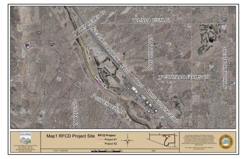
W TWIN PEAKS RD<br />
W LINDA VISTA BL<br />
N CASA GRANDE HY<br />
N HARTMAN LN<br />
Project #2<br />
N THORNYDALE RD<br />
E I10 W I10<br />
W CORTARO FARMS RD<br />
Project #1<br />
W I10 FRONTAGE RD<br />
N SILVERBELL RD<br />
N WADE RD<br />
<strong>Pima</strong> <strong>County</strong> Regional <strong>Flood</strong> <strong>Control</strong> <strong>District</strong><br />
97 E Congress - 3rd Floor<br />
Tucson, Arizona 85701-1207<br />
(520) 243-1800, FAX: (520)243-1821<br />
http://www.rfcd.pima.gov<br />
Map1 RFCD Project Site<br />
1 inch = 2,000 feet<br />
RFCD Project<br />
©<br />
Project #1<br />
Project #2<br />
0 500 1,000 2,000 3,000 4,000<br />
Feet<br />
Date:<br />
The information depicted on this display is the result<br />
of digital analyses performed on a variety of databases<br />
provided and maintained by several governmental agencies.<br />
The accuracy of the information presented is limited to<br />
the collective accuracy of these databases on the date<br />
of the analysis. The <strong>Pima</strong> <strong>County</strong> Regional <strong>Flood</strong> <strong>Control</strong><br />
<strong>District</strong> makes no claims regarding the accuracy of the information<br />
depicted herein.<br />
This product is subject to the GIS Division Disclaimer<br />
and Use Restrictions.
N ANWAY RD<br />
N TRICO RD<br />
N 1ST AV<br />
N CAMPBELL AV<br />
W SILVERBELL RD<br />
N PUMP STATION RD<br />
W EL TIRO RD<br />
W AVRA VALLEY RD<br />
N ANWAY RD<br />
G"/<br />
SC-12<br />
G<br />
SC-11<br />
W SILVERBELL RD<br />
W MARANA RD<br />
N SANDERS RD<br />
G<br />
E I10 W I10<br />
SC-10<br />
N SANDARIO RD<br />
G<br />
SC-09<br />
W AVRA VALLEY RD<br />
G<br />
W TWIN PEAKS RD<br />
W PICTURE ROCKS RD<br />
SC-08<br />
SC-07<br />
G<br />
W MOORE RD<br />
W TANGERINE RD<br />
G<br />
N WADE RD<br />
SC-06<br />
G<br />
G<br />
SC-05<br />
SC-04<br />
!( "/<br />
W TWIN PEAKS RD<br />
W LINDA VISTA BL<br />
SC-03<br />
Ina Rd WRF<br />
G<br />
N CAMINO DE OESTE<br />
!(<br />
N THORNYDALE RD<br />
N SHANNON RD<br />
W LAMBERT LN<br />
N LA CHOLLA BL<br />
W NARANJA DR<br />
W INA RD<br />
W HARDY RD<br />
W MAGEE RD<br />
E TANGERINE RD<br />
E LAMBERT LN<br />
E SKYLINE DR<br />
W MANVILLE RD<br />
W GOLDEN GATE RD<br />
N SILVERBELL RD<br />
W SUNSET RD<br />
G<br />
SC-02<br />
G<br />
!(<br />
SC-01<br />
W GORET RD<br />
Roger Rd WRF<br />
N LA CANADA DR<br />
N ORACLE RD<br />
E RIVER RD<br />
©<br />
N FREEWAY<br />
N STONE AV<br />
<strong>Pima</strong> <strong>County</strong> Regional <strong>Flood</strong> <strong>Control</strong> <strong>District</strong><br />
97 E Congress - 3rd Floor<br />
Tucson, Arizona 85701-1207<br />
(520) 243-1800, FAX: (520)243-1821<br />
http://www.rfcd.pima.gov<br />
Map 2<br />
Lower Santa Cruz River Sampling Sites<br />
1 inch = 10,000 feet<br />
!( ADEQ Sampling Sites<br />
"/ USGS Stream Gauge<br />
RWRD Sampling Sites<br />
G<br />
Study Reach (Lower Santa Cruz River)<br />
0 2,550 5,100 10,200 15,300 20,400<br />
Feet<br />
Date:<br />
The information depicted on this display is the result<br />
of digital analyses performed on a variety of databases<br />
provided and maintained by several governmental agencies.<br />
The accuracy of the information presented is limited to<br />
the collective accuracy of these databases on the date<br />
of the analysis. The <strong>Pima</strong> <strong>County</strong> Regional <strong>Flood</strong> <strong>Control</strong><br />
<strong>District</strong> makes no claims regarding the accuracy of the information<br />
depicted herein.<br />
This product is subject to the GIS Division Disclaimer<br />
and Use Restrictions.