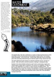
Geology of the Australian Alps - Australian Alps National Parks
Geology of the Australian Alps - Australian Alps National Parks
Geology of the Australian Alps - Australian Alps National Parks

You also want an ePaper? Increase the reach of your titles
YUMPU automatically turns print PDFs into web optimized ePapers that Google loves.
geology<br />
<strong>of</strong> THE AUSTRALIAN<br />
ALPS<br />
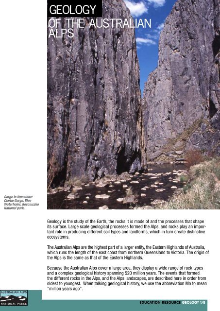
Gorge in limestone:<br />
Clarke Gorge, Blue<br />
Waterholes, Kosciuszko<br />
<strong>National</strong> park.<br />
<strong>Geology</strong> is <strong>the</strong> study <strong>of</strong> <strong>the</strong> Earth, <strong>the</strong> rocks it is made <strong>of</strong> and <strong>the</strong> processes that shape<br />
its surface. Large scale geological processes formed <strong>the</strong> <strong>Alps</strong>, and rocks play an important<br />
role in producing different soil types and landforms, which in turn create distinctive<br />
ecosystems.<br />
The <strong>Australian</strong> <strong>Alps</strong> are <strong>the</strong> highest part <strong>of</strong> a larger entity, <strong>the</strong> Eastern Highlands <strong>of</strong> Australia,<br />
which runs <strong>the</strong> length <strong>of</strong> <strong>the</strong> east coast from nor<strong>the</strong>rn Queensland to Victoria. The origin <strong>of</strong><br />
<strong>the</strong> <strong>Alps</strong> is <strong>the</strong> same as that <strong>of</strong> <strong>the</strong> Eastern Highlands.<br />
Because <strong>the</strong> <strong>Australian</strong> <strong>Alps</strong> cover a large area, <strong>the</strong>y display a wide range <strong>of</strong> rock types<br />
and a complex geological history spanning 520 million years. The events that formed<br />
<strong>the</strong> different rocks in <strong>the</strong> <strong>Alps</strong>, and <strong>the</strong> <strong>Alps</strong> landscapes, are described here in order from<br />
oldest to youngest. When talking geological history, we use <strong>the</strong> abbreviation Ma to mean<br />
“million years ago”.<br />
EDUCATION RESOURCE GEOLOGY 1/8
geology<br />
early<br />
history.<br />
deep oceans<br />
and ancient<br />
mountains<br />
Earth’s surface is continually being reshaped and modified by geological processes.<br />
Sou<strong>the</strong>astern Australia has only existed as a continuous landmass for about 350 million<br />
years, and its appearance has changed radically during that time. Before 350 Ma, <strong>the</strong>re<br />
were oceans and island chains where <strong>the</strong>re is now dry land.<br />
The oldest rocks in <strong>the</strong> alpine region are basalt lavas erupted onto <strong>the</strong> deep ocean<br />
floor about 520 Ma, in <strong>the</strong> Cambrian period. They occur in Victoria in <strong>the</strong> Howqua Valley and<br />
<strong>the</strong> remote Dolodrook Valley. At this time eastern Australia did not exist – <strong>the</strong> region<br />
was a deep ocean dotted with volcanic islands, similar to <strong>the</strong> western Pacific Ocean <strong>of</strong><br />
today.<br />
During <strong>the</strong> next 80 million years, in <strong>the</strong> Ordovician period, vast areas <strong>of</strong> <strong>the</strong> ocean<br />
floor were covered by a thick blanket <strong>of</strong> sand and mud, over time turning into <strong>the</strong><br />
sedimentary rocks sandstone and mudstone. These rocks form much <strong>of</strong> <strong>the</strong> <strong>Australian</strong><br />
<strong>Alps</strong>. In this time interval a large chain <strong>of</strong> volcanic islands formed in what is now New<br />
South Wales, erupting basalt and andesite lava. These rocks are seen in <strong>the</strong> Kiandra<br />
and Jagungal areas.<br />
Geological map <strong>of</strong> <strong>the</strong><br />
<strong>Australian</strong> <strong>Alps</strong> region.<br />
Neogene-Holocene river<br />
and coastal sediments<br />
Late Devonian<br />
sandstone and mudstone<br />
Ordovician-Silurian basalt<br />
and related rocks<br />
Paleogene-Neogene<br />
basalt<br />
Silurian-Devonian<br />
rhyolite and limestone<br />
Silurian schist<br />
and gneiss<br />
Triassic-Cretaceous<br />
granite<br />
Silurian-Devonian<br />
granite<br />
Ordovician deep<br />
marine rocks<br />
EDUCATION RESOURCE GEOLOGY 2/8
geology<br />
From 440 to 360 Ma (<strong>the</strong> Silurian and Devonian periods) a series <strong>of</strong> mountain-building<br />
events folded <strong>the</strong> sedimentary and volcanic rocks, lifted <strong>the</strong>m out <strong>of</strong> <strong>the</strong> sea to form land<br />
and moved blocks <strong>of</strong> crust tens to hundreds <strong>of</strong> kilometres along large faults. This was <strong>the</strong><br />
result <strong>of</strong> collisions <strong>of</strong> several small tectonic plates, crumpling rocks toge<strong>the</strong>r and thickening<br />
up <strong>the</strong> crust. In addition, some rocks were buried deep in <strong>the</strong> crust and heated, <strong>the</strong>reby<br />
becoming metamorphosed to produce rocks such as slate, schist and gneiss. Slate is<br />
common throughout <strong>the</strong> high country, with good examples at Mt Hotham and Mt Fea<strong>the</strong>rtop<br />
in Victoria. Schist and gneiss occur in <strong>the</strong> Victorian <strong>Alps</strong> around Mt Bogong, Falls Creek<br />
and Omeo. Some rocks were heated above 650º C, enough to melt <strong>the</strong>m.<br />
The Ca<strong>the</strong>dral on<br />
Mt Buffalo – large<br />
granite tors.<br />
Also in <strong>the</strong> Silurian and Devonian, large bodies <strong>of</strong> granite were emplaced into <strong>the</strong> crust<br />
and huge volcanoes erupted ash and lava over <strong>the</strong> newly created land. Granite forms<br />
much <strong>of</strong> <strong>the</strong> high country, such as <strong>the</strong> Kosciuszko Plateau in NSW, <strong>the</strong> Bimberi and Clear<br />
Ranges in <strong>the</strong> ACT, and Mt Buffalo, Mt Baw Baw and Mt Wills in Victoria. Many granite<br />
bodies are resistant to erosion, and hence form plateaus and ridges with large blocks,<br />
or tors, <strong>of</strong> rock sticking up, while surrounding rocks are more susceptible to erosion and<br />
form lower country. Not all granites are resistant, however, and some are more recessive<br />
(i.e. more easily eroded) than <strong>the</strong> surrounding rocks, forming broad valleys as at<br />
Cudgewa-Thowgla and Ensay-Swifts Creek in Victoria.<br />
EDUCATION RESOURCE GEOLOGY 3/8
geology<br />
The volcanoes <strong>of</strong> <strong>the</strong> Silurian and Devonian periods were quite explosive, erupting towering<br />
clouds <strong>of</strong> hot volcanic ash which formed a rock known as ignimbrite. In Victoria this<br />
type <strong>of</strong> rock occurs at lake Mountain, Mt Donna Buang and <strong>the</strong> Snowy River area, while<br />
similar rocks occur around Lake Talbingo and along <strong>the</strong> Fiery Range in New South Wales.<br />
During <strong>the</strong> Silurian and Devonian periods <strong>the</strong> geography <strong>of</strong> sou<strong>the</strong>astern Australia was<br />
complex, with small seas and large to small islands. Some islands developed coral reefs<br />
along <strong>the</strong>ir edges, which over time became limestone. This rock commonly has many<br />
fossils such as coral, shells and algae. Because limestone is soluble in slightly acidic<br />
groundwater, it easily dissolves to form caves and gorges, as seen at Yarrangobilly and<br />
Blue Water Holes in NSW, and Buchan in Victoria.<br />
By about 360 Ma much <strong>of</strong> sou<strong>the</strong>astern Australia was a mountain range. Note that this<br />
range had nothing to do with <strong>the</strong> present-day <strong>Australian</strong> <strong>Alps</strong>, and was part <strong>of</strong> an ancient<br />
cycle <strong>of</strong> plate tectonic movements. Wide valleys within and adjacent to <strong>the</strong> mountains<br />
were filled with river and lake sediments, forming sandstone and mudstone with a distinctive<br />
reddish colour. They can be seen in Victoria in <strong>the</strong> high plateaus stretching from<br />
Mt Cobbler to <strong>the</strong> Avon Wilderness area.<br />
geologically<br />
quiet time<br />
After <strong>the</strong> last episode <strong>of</strong> folding, about 340 Ma, sou<strong>the</strong>astern Australia entered a 200<br />
million year period where not much happened, geologically speaking. Australia was part<br />
<strong>of</strong> <strong>the</strong> supercontinent <strong>of</strong> Gondwana, lying in <strong>the</strong> interior <strong>of</strong> <strong>the</strong> landmass. The mountain<br />
ranges were slowly worn down to a low-lying plain and very few rocks <strong>of</strong> this period are<br />
preserved in <strong>the</strong> alpine region.<br />
Around 300-250 Ma <strong>the</strong> Earth entered a global ice age, and at this time Australia was close<br />
to <strong>the</strong> south pole. Ice sheets covered much <strong>of</strong> sou<strong>the</strong>rn Australia, and glacial deposits are<br />
preserved outside <strong>the</strong> alpine region in Victoria and New South Wales. Any such deposits<br />
within <strong>the</strong> <strong>Australian</strong> <strong>Alps</strong> have been since eroded away.<br />
latest<br />
period.<br />
formation<br />
<strong>of</strong> <strong>the</strong><br />
australian<br />
alps<br />
There is still debate about when <strong>the</strong> <strong>Australian</strong> <strong>Alps</strong> came into existence, with some<br />
geologists arguing that <strong>the</strong>y arose only a few million years ago, while <strong>the</strong> majority argue<br />
that <strong>the</strong> <strong>Alps</strong> arose around 100-60 Ma, based on evidence collected over <strong>the</strong> last 30<br />
years. This account takes <strong>the</strong> majority view.<br />
About 130 Ma stirrings in <strong>the</strong> deep mantle began to break up eastern Gondwana. Australia<br />
began <strong>the</strong> long process <strong>of</strong> breaking away from Antarctica and Zealandia (a now largely<br />
submerged continent stretching from New Zealand to New Caledonia). The process began<br />
with magma moving upwards into <strong>the</strong> lithosphere, causing it to heat and expand upward,<br />
forming a dome-shaped plateau running along what is now <strong>the</strong> east coast <strong>of</strong> Australia. By<br />
100 Ma <strong>the</strong> plateau was possibly over 2000 m high in its highest area, <strong>the</strong> site <strong>of</strong> today’s<br />
<strong>Australian</strong> <strong>Alps</strong>. Gondwana split apart along this line <strong>of</strong> magma upwelling, and a rift valley<br />
formed along <strong>the</strong> centre <strong>of</strong> <strong>the</strong> plateau, with an east-west trending branch where Tasmania<br />
moved southward away from Victoria. The rift valley, similar to today’s East African Rift<br />
Valley, was formed by stretching <strong>of</strong> <strong>the</strong> crust leading to <strong>the</strong> valley floor dropping along<br />
a series <strong>of</strong> faults.<br />
EDUCATION RESOURCE GEOLOGY4/8
geology<br />
Zealandia moved eastwards, with <strong>the</strong> Tasman Sea filling in <strong>the</strong> gap, while Tasmania only<br />
moved a short distance southwards, forming <strong>the</strong> shallow Bass Strait. The <strong>Australian</strong> <strong>Alps</strong><br />
were left behind as a remnant <strong>of</strong> <strong>the</strong> original plateau, with a steep seaward side and a<br />
gentle slope toward <strong>the</strong> inland. By 65 Ma <strong>the</strong> Tasman Sea and Bass Strait were in <strong>the</strong>ir<br />
current configuration and <strong>the</strong> <strong>Australian</strong> <strong>Alps</strong> were probably not much higher than <strong>the</strong>y<br />
are today. Since <strong>the</strong>n erosion has carved deep valleys into <strong>the</strong> plateau and rounded <strong>of</strong>f<br />
<strong>the</strong> landforms. In New South Wales most <strong>of</strong> <strong>the</strong> alpine area is one large tableland, while<br />
in Victoria erosion has proceeded fur<strong>the</strong>r, producing many smaller plateaus separated by<br />
rugged valleys.<br />
Over <strong>the</strong> last 50 Ma basalt lava has been erupted episodically over much <strong>of</strong> <strong>the</strong> alpine<br />
region. The lava came out <strong>of</strong> small volcanoes and flowed across <strong>the</strong> landscape and down<br />
valleys. Many <strong>of</strong> <strong>the</strong> high plains in Victoria are covered by basalt, such as <strong>the</strong> Bogong,<br />
Dargo and Nunniong High Plains. In New South Wales <strong>the</strong> Monaro Plain is a large area <strong>of</strong><br />
basalt lava flows. Because basalt lava is quite fluid, it quickly fills in <strong>the</strong> low-lying areas to<br />
form <strong>the</strong> flat landscapes <strong>of</strong> <strong>the</strong>se high plains.<br />
Although <strong>the</strong> <strong>Alps</strong> were mostly in place by about 90 Ma, <strong>the</strong>re have been several minor<br />
uplift episodes since <strong>the</strong>n in various parts <strong>of</strong> <strong>the</strong> <strong>Alps</strong>. These events have in many cases<br />
altered <strong>the</strong> course <strong>of</strong> rivers by tilting and faulting, in some cases reversing <strong>the</strong>ir flow and<br />
sending <strong>the</strong>m in new directions.<br />
Formation <strong>of</strong> <strong>the</strong><br />
<strong>Australian</strong> <strong>Alps</strong>.<br />
130 million yers ago 100 million yers ago<br />
80 million yers ago<br />
present<br />
EDUCATION RESOURCE GEOLOGY 5/8
geology<br />
The<br />
pleistocene<br />
ice age<br />
Most <strong>of</strong> <strong>the</strong> last 2 million years have been a time <strong>of</strong> global ice age, with ice caps forming on<br />
high ranges around <strong>the</strong> world, as well as at <strong>the</strong> poles. This cold period is known to geologists<br />
as <strong>the</strong> Pleistocene epoch. Because <strong>the</strong> <strong>Australian</strong> <strong>Alps</strong> are only <strong>of</strong> modest height,<br />
<strong>the</strong> highest point being Mt Kosciuszko at 2228 m, glaciers were formed only on <strong>the</strong> very<br />
highest parts (above 2000 m) in <strong>the</strong> vicinity <strong>of</strong> Mt Kosciuszko. Several tarns and cirques<br />
remain: <strong>the</strong>se result from glaciers scooping out hollows in <strong>the</strong> ground. Examples <strong>of</strong> tarns,<br />
which filled <strong>the</strong> bottom <strong>of</strong> cirques after <strong>the</strong> ice melted about 12,000 years ago, are Club<br />
Lake, Blue Lake and Hedley Tarn. Some <strong>of</strong> <strong>the</strong> small valleys near Mt Kosciuszko have <strong>the</strong><br />
U-shaped cross section typical <strong>of</strong> valleys carved by glaciers.<br />
Much <strong>of</strong> <strong>the</strong> <strong>Australian</strong> <strong>Alps</strong> outside <strong>the</strong> small glaciated area was still affected by cold<br />
conditions during <strong>the</strong> Pleistocene, indicated by periglacial features such as block streams,<br />
terracing and frost-shattered boulders. These features all require ice to be present in<br />
rocks and soil for much <strong>of</strong> <strong>the</strong> time.<br />
Are <strong>the</strong><br />
<strong>Australian</strong> <strong>Alps</strong><br />
geologically<br />
unique?<br />
The shape <strong>of</strong> <strong>the</strong> <strong>Australian</strong> <strong>Alps</strong> is quite different to that <strong>of</strong> <strong>the</strong> more famous<br />
mountain ranges such as <strong>the</strong> European <strong>Alps</strong> or <strong>the</strong> Himalayas. Those mountains<br />
contain many sharp peaks and deep glacial valleys. In contrast, <strong>the</strong> skyline <strong>of</strong> <strong>the</strong><br />
<strong>Australian</strong> <strong>Alps</strong> is ra<strong>the</strong>r flat and rounded. It is <strong>of</strong>ten said that this is because <strong>the</strong><br />
<strong>Australian</strong> <strong>Alps</strong> are much older than <strong>the</strong> European <strong>Alps</strong> and Himalayas, and erosion<br />
over time has worn <strong>the</strong>m down. However this is only a small part <strong>of</strong> <strong>the</strong> answer.<br />
There are two main reasons <strong>the</strong> <strong>Australian</strong> <strong>Alps</strong> are flat and smooth. Firstly, <strong>the</strong>y<br />
originated by a different plate tectonic process, continental splitting, ra<strong>the</strong>r than<br />
continental collision which formed <strong>the</strong> European <strong>Alps</strong> and <strong>the</strong> Himalayas. Uplift in<br />
continental collisions is much faster and <strong>of</strong>ten <strong>of</strong> greater magnitude than <strong>the</strong> slow<br />
process <strong>of</strong> uplift during continental splitting. Secondly, <strong>the</strong> <strong>Australian</strong> <strong>Alps</strong> were never<br />
high enough to have large ice sheets and glaciers, and it is <strong>the</strong> erosion by ice that<br />
produces <strong>the</strong> sharp and jagged peaks <strong>of</strong> <strong>the</strong> Himalayas and European <strong>Alps</strong>.<br />
Does this <strong>the</strong>n make <strong>the</strong> <strong>Australian</strong> <strong>Alps</strong> geologically unique? The answer is no, as<br />
around <strong>the</strong> world <strong>the</strong>re are many mountain ranges formed in <strong>the</strong> same way as <strong>the</strong><br />
<strong>Australian</strong> <strong>Alps</strong> (and <strong>the</strong> Eastern Highlands in general), such as <strong>the</strong> Drakensburg in<br />
South Africa, <strong>the</strong> Western Ghats in India and <strong>the</strong> mountains <strong>of</strong> Norway. And to see<br />
how our <strong>Alps</strong>’ Eastern Highlands may have looked at about 70 Ma, we can study <strong>the</strong><br />
mountains on each side <strong>of</strong> <strong>the</strong> Red Sea. Even though quite young, <strong>the</strong> Red Sea<br />
mountains have a similar topography to <strong>the</strong> <strong>Australian</strong> <strong>Alps</strong>, with large plateaus dropping<br />
steeply to <strong>the</strong> sea. However, erosion has not had time to round <strong>of</strong>f <strong>the</strong>ir shapes.<br />
EDUCATION RESOURCE GEOLOGY 6/8
geology<br />
Geological Time range<br />
period<br />
Holocene 10,000<br />
years ago to<br />
present<br />
Pleistocene 2.6 Ma to<br />
10,000 years<br />
ago<br />
Events<br />
The ice cap melted and sou<strong>the</strong>astern Australia became warmer and<br />
wetter. Erosion continued, but has recently been modified by <strong>the</strong> building<br />
<strong>of</strong> dams, clearing <strong>of</strong> forests and overgrazing.<br />
A global ice age affected <strong>the</strong> earth. Cold, dry conditions prevailed in<br />
Australia, and a small ice cap formed around Mt Kosciuszko.<br />
Neogene 23–2.6 Ma Several episodes <strong>of</strong> uplift along faults raised parts <strong>of</strong> <strong>the</strong> <strong>Alps</strong> even<br />
higher. Some basalt lava was erupted in several localities. Australia<br />
moved quickly northwards into warmer and wetter climate zones, and<br />
erosion continued to shape <strong>the</strong> <strong>Alps</strong>.<br />
Paleogene 65–23 Ma The <strong>Alps</strong> were in place as a high plateau along <strong>the</strong> sou<strong>the</strong>ast coast <strong>of</strong><br />
Australia. Australia began moving away from Antarctica into more nor<strong>the</strong>rly<br />
latitudes. Eruption <strong>of</strong> basalt lava occurred in many parts <strong>of</strong> <strong>Alps</strong>.<br />
Erosion <strong>of</strong> <strong>the</strong> <strong>Alps</strong> continued to deepen valleys and isolate plateaus.<br />
Cretaceous 130–65 Ma Australia started to separate from Gondwana, firstly India moved<br />
westwards from Australia, <strong>the</strong>n a large plateau arose along what is now<br />
<strong>the</strong> east coast <strong>of</strong> Australia – <strong>the</strong> beginnings <strong>of</strong> <strong>the</strong> <strong>Australian</strong> <strong>Alps</strong>. By<br />
100 Ma <strong>the</strong> plateau was riven by a rift valley that ran along <strong>the</strong> east<br />
coast <strong>of</strong> New South Wales and <strong>the</strong> south coast <strong>of</strong> Victoria. Antarctica<br />
and Tasmania moved southwards slightly while Zealandia move quickly<br />
eastwards, forming <strong>the</strong> Tasman Sea by 60 Ma.<br />
Carboniferous,<br />
Permian,<br />
Triassic,<br />
Jurassic and<br />
early<br />
Cretaceous<br />
Late Devonian<br />
to Early<br />
Carboniferous<br />
Silurian<br />
to Middle<br />
Devonian<br />
340–130 Ma A long period <strong>of</strong> erosion and wea<strong>the</strong>ring slowly wore down <strong>the</strong> early<br />
mountain ranges to a low plain covering most <strong>of</strong> eastern Australia. By<br />
now Australia was part <strong>of</strong> <strong>the</strong> supercontinent <strong>of</strong> Gondwana. Between<br />
300 Ma and 250 Ma glaciers covered much <strong>of</strong> sou<strong>the</strong>rn Australia during<br />
<strong>the</strong> Permian ice age.<br />
360–340 Ma A final period <strong>of</strong> folding and mountain building occurred, with sand<br />
and mud deposited in rivers and lakes in broad valleys between <strong>the</strong><br />
mountain ranges.<br />
440–360 Ma Several episodes <strong>of</strong> folding and mountain building, caused by tectonic<br />
plates colliding with each o<strong>the</strong>r, created islands and <strong>the</strong>n more<br />
continuous land masses. In <strong>the</strong> shallow seas next to <strong>the</strong> islands coral<br />
reefs grew and later turned into limestone. Generation <strong>of</strong> magma deep<br />
in <strong>the</strong> crust led to granite bodies being intruded into <strong>the</strong> crust and<br />
explosive volcanoes on <strong>the</strong> surface. Some rocks were buried deeply and<br />
metamorphosed into schist and gneiss.<br />
Ordovician 490–440 Ma Much <strong>of</strong> <strong>the</strong> area was still in <strong>the</strong> deep ocean. Several kilometres <strong>of</strong> sand<br />
and mud were deposited on <strong>the</strong> ocean floor. In New South Wales a chain<br />
<strong>of</strong> volcanoes formed a series <strong>of</strong> small islands in <strong>the</strong> ocean.<br />
Mid to late<br />
Cambrian<br />
520–490 Ma The area now occupied by <strong>the</strong> <strong>Australian</strong> <strong>Alps</strong> was a deep ocean, with<br />
basalt lava erupting onto <strong>the</strong> ocean floor and also forming scattered<br />
volcanic islands.<br />
EDUCATION RESOURCE GEOLOGY 7/8
geology<br />
References<br />
Birch W.D. (ed.). (2003). The <strong>Geology</strong> <strong>of</strong> Victoria. Geological Society <strong>of</strong> Australia (Victorian Division), Sydney.<br />
Branagan D. F. and Packham G. H. (2000) Field <strong>Geology</strong> <strong>of</strong> New South Wales, 3rd edn, NSW Department <strong>of</strong> Mineral<br />
Resources, Sydney.<br />
Johnson D. P. (2009) The <strong>Geology</strong> <strong>of</strong> Australia, 2nd edn, Cambridge University Press, Cambridge.<br />
Scheibner E. and Basden H. (ed.) 1998. <strong>Geology</strong> <strong>of</strong> New South Wales. Volume 2 Geological Evolution.<br />
Geological Survey <strong>of</strong> New South Wales Memoir 13. Department <strong>of</strong> Mineral Resources.<br />
VandenBerg A.H.M. (2010). Paleogene basalts prove early uplift <strong>of</strong> Victoria’s Eastern uplands. <strong>Australian</strong> Journal <strong>of</strong><br />
Earth Sciences 57, 291-315.<br />
Web sites: Geological history <strong>of</strong> Victoria: http://www.vic.gsa.org.au/Victorian_<strong>Geology</strong>.html<br />
Poster <strong>of</strong> Australia through time:<br />
https://www.ga.gov.au/products/servlet/controller?event=GEOCAT_DETAILS&catno=71079<br />
Glossary<br />
andesite: a black or dark green volcanic rock with intermediate amounts <strong>of</strong> silicon.<br />
basalt: a black volcanic rock with low silicon and high magnesium and iron.<br />
block stream: a “river” or field <strong>of</strong> rocks that have moved downhill as a mass, held toge<strong>the</strong>r by ice forming between <strong>the</strong> blocks.<br />
cirque: a bowl-shaped depression formed at <strong>the</strong> head <strong>of</strong> a glacier by <strong>the</strong> scraping action <strong>of</strong> <strong>the</strong> ice.<br />
crust: <strong>the</strong> uppermost layer <strong>of</strong> Earth. Crust forming <strong>the</strong> continents is 30 to 70 km thick; crust forming <strong>the</strong> ocean floor is 5<br />
to 7 km thick.<br />
gneiss: a layered metamorphic rock formed at high temperatures (> 600º C).<br />
Gondwana: <strong>the</strong> supercontinent consisting <strong>of</strong> Australia, Antarctica, New Zealand, India, Africa and South America. It was<br />
assembled over <strong>the</strong> period 500 Ma to 200 Ma, and began to break up into fragments about 180 Ma. Australia was one <strong>of</strong><br />
<strong>the</strong> last fragments to separate.<br />
granite: a common igneous rock formed at depth in <strong>the</strong> crust, consisting <strong>of</strong> interlocking crystals <strong>of</strong> quartz and feldspar<br />
and minor dark coloured minerals. Commonly forms large rounded tors.<br />
ignimbrite: a volcanic rock <strong>of</strong> high silicon content formed by hot ash accumulating around a volcano during an<br />
explosive eruption; generally whitish with small crystals <strong>of</strong> quartz and/or feldspar.<br />
lava: magma that has erupted onto <strong>the</strong> Earth’s surface.<br />
limestone: a sedimentary rock composed <strong>of</strong> calcium carbonate, formed by <strong>the</strong> accumulation <strong>of</strong> animal shells, coral and<br />
o<strong>the</strong>r biological matter.<br />
lithosphere: <strong>the</strong> outer rigid layer <strong>of</strong> Earth, consisting <strong>of</strong> <strong>the</strong> crust and <strong>the</strong> uppermost mantle.<br />
magma: molten rock, <strong>of</strong>ten containing solid crystals. When magma solidifies, it forms an igneous rock.<br />
metamorphism: changes in <strong>the</strong> mineral make-up and structure <strong>of</strong> a rock due to <strong>the</strong> application <strong>of</strong> heat and/or pressure.<br />
Temperature increases with depth in <strong>the</strong> Earth, so rocks buried deeply get hot as well as being put under immense<br />
pressure from <strong>the</strong> weight <strong>of</strong> <strong>the</strong> overlying rocks.<br />
periglacial: pertaining to areas that were not covered by glaciers, but underwent geomorphic processes related to <strong>the</strong><br />
freezing <strong>of</strong> water.<br />
plate tectonics: <strong>the</strong> formation <strong>of</strong> large structures on <strong>the</strong> Earth, such as continents, oceans and mountain ranges, by <strong>the</strong><br />
movement <strong>of</strong> large rigid blocks (plates) <strong>of</strong> lithosphere over <strong>the</strong> Earth’s surface at rates <strong>of</strong> a few cm per year. Plates may move<br />
toward or away from each o<strong>the</strong>r, or slide past east each o<strong>the</strong>r, each type <strong>of</strong> movement creating different structures.<br />
rift valley: a large valley bounded by faults and formed by stretching apart <strong>of</strong> <strong>the</strong> continental crust; <strong>of</strong>ten <strong>the</strong> first stage<br />
in <strong>the</strong> development <strong>of</strong> a new ocean.<br />
mantle: <strong>the</strong> largest part <strong>of</strong> <strong>the</strong> Earth, immediately below <strong>the</strong> crust and extending down to 2900 km depth; composed <strong>of</strong><br />
dense minerals rich in magnesium and iron.<br />
schist: a metamorphic rock containing a large proportion <strong>of</strong> aligned mica minerals which give it a sparking sheen.<br />
sedimentary rock: rock formed by <strong>the</strong> accumulation <strong>of</strong> sediment, such as sand grains, clay particles, pebbles, chemical<br />
precipitates, or by <strong>the</strong> accumulation <strong>of</strong> biologically produced material.<br />
slate: a fine-grained metamorphic rock formed at relatively low temperature (250º - 450º C), and characterised by an<br />
alignment <strong>of</strong> microscopic platy minerals which cause <strong>the</strong> rock split along parallel planes known as cleavage planes.<br />
tarn: a small lake filling <strong>the</strong> bottom <strong>of</strong> a cirque; also known as a cirque lake.<br />
tectonic plates: parts <strong>of</strong> <strong>the</strong> lithosphere that move relative to each o<strong>the</strong>r; typically thousands <strong>of</strong> kilometres across.<br />
terracing: steps formed on hill sides by mass movement <strong>of</strong> ice- and water-saturated soil down-slope<br />
A U S T R A L I A N A L P S<br />
TRADITIONAL OWNERS<br />
A NATIONAL HERITAGE<br />
LISTED SITE<br />
www.environment.gov.au/heritage<br />
EDUCATION RESOURCE GEOLOGY 8/8