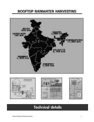
Chennai terrain guide - Rainwater Harvesting
Chennai terrain guide - Rainwater Harvesting
Chennai terrain guide - Rainwater Harvesting

Create successful ePaper yourself
Turn your PDF publications into a flip-book with our unique Google optimized e-Paper software.
TERRAIN GUIDE OF CHENNAI CITY<br />
Introduction<br />
<strong>Chennai</strong> and its suburbs – constituting the <strong>Chennai</strong> Metropolitan Area (CMA) are<br />
constantly plagued by water shortage. Rapid growth in population, coupled with<br />
irregular spells of monsoons has further intensified the problem in the past couple of<br />
years. The population of <strong>Chennai</strong> is expected to cross 4.5 million by the end of 2004.<br />
The city at the moment requires 848 million litres per day (MLD). Whereas the public<br />
system was able to supply only 433 MLD. The balance of nearly 50% of the daily<br />
consumption is met through private wells and borewells (groundwater). As a result of<br />
this unplanned large scale extraction of groundwater the water table in the city is<br />
depleting at an alarming rate causing serious quality problems. Hence it becomes<br />
essential to sustain the available limited groundwater sources through rainwater<br />
harvesting.<br />
To design a proper rainwater harvesting system for groundwater recharge,<br />
parameters such as Geology, Hydrogeology and Hydrometeorology is required. As<br />
the Geology of <strong>Chennai</strong> city is highly complex and heterogeneous in nature,<br />
rainwater harvesting systems designed without considering the local hydro geological<br />
set up will not yield the desired results. The present study is to bring out an over<br />
view of the sub <strong>terrain</strong> configuration in <strong>Chennai</strong> city based on which <strong>terrain</strong> specific<br />
water harvesting systems can be designed.<br />
CITY AT A GLANCE<br />
Location<br />
<strong>Chennai</strong> District is bounded by North Latitudes 12° 59’ 10” and 13° 08’ 50” and east<br />
Longitudes 80° 12’ 10” and 80° 18’ 20” and forms part of survey of India<br />
Topographical Maps Nos. 66 C / 4 & and 66 D 1 and 5. The Geographical area of<br />
<strong>Chennai</strong> district is 170 .98 Sq. km and the extent of <strong>Chennai</strong> Metropolitan Area is<br />
1170 Sq. km. (Refer Base map)
Land use and Administration.
The Forest Cover in <strong>Chennai</strong> district is only 300 ha (1.8 percent) and the rest 98.2<br />
per cent of the areas is used for industrial purposes. The residential areas can be<br />
grouped as Prime residential , Commerical, mixed residential and slum areas.<br />
Presentely there are five taluks in the district, namely<br />
(i) Purasavalkam Perambur<br />
(ii) Fort – Tondiarpet<br />
(iii) Mambalam- Guindy<br />
(iv) Mylapore –Triplicane<br />
(v) Egmore - Nungambakkam<br />
Profile of <strong>Chennai</strong> Metropolitan area (Part) - General Features – Statistics.<br />
1. Location <strong>Chennai</strong> city and part of Tambaram taluk.<br />
2. Total area 174 sq km.<br />
3. Population 42.16 lakh (city) 65.0 L (Metropolitan area)<br />
4. Major rivers traversing the area Adyar and Cooum, Otteri nullah.<br />
5. Canal Buckingham canal<br />
6. Mean Annual Rainfall (50 yr) 1320 mm<br />
7. Cooum and Adyar basin<br />
Rainfall 50% dependability<br />
SW<br />
445<br />
524<br />
NE<br />
765<br />
788<br />
Annual<br />
1245<br />
1385<br />
8. Population density 24,231 persons / sq km.<br />
9. Geology Crystalline basement rock, Upper<br />
Gondwanas, Tertiary and Recent to Sub<br />
Recent Alluvium.<br />
10. Terrain slope 1:1500<br />
11. Forest cover 274.57 hectare (1.5% of the total area<br />
under forest)<br />
12. Cultivable waste 3,48,497 hectare (8,60,788 acres)<br />
13. Cultivable Fallow 9,55,507 hectare (23,60,102 acres)<br />
14. Other fallow 11,10,728 hectare (27,43,498 acres)<br />
Total - 24,14,732 hectares (59,64,388<br />
acres)<br />
15. Sewerage generation 540 mld (city only)<br />
16. Garbage generation 3000 tones/ day. (2400 tones<br />
biodegradable in city only)<br />
17. Corporation roads 302 km<br />
18. Bus route& interior roads 1900 km<br />
19. Total vehicle population 13,00,000 (2001 approx)<br />
20. Industries in <strong>Chennai</strong> 770 (as on 2000)<br />
21. Coastline 22 km (city only)<br />
22. Water supply during normal RF 78 lit per capita a day (LPCD)<br />
313 mld<br />
23. During drought period 127 mld 32 LPCD.<br />
(Based on 1998 – 99 Tamil Nadu Land Use Board statistics).
GEOMORPHOLOGY<br />
<strong>Chennai</strong> district forms parts of Tamilnadu costal plains. Major part of the district is<br />
having flat topography with very gentle slope towards east. The altitude of land<br />
surface varies from 10 m above MSL in the west to sea level in the east. Fluvial,<br />
Marine transgression and regression and neo tectonic activity resulted in various<br />
present land forms.<br />
Meandering streams with small sand bars are present along the course of Adayar<br />
River. The river shows some sharp angular trends in its course which may be the<br />
indication of the hidden structural features below. The pediment and buried pediment<br />
in Guindy area in and around the reserved forest, are the only areas where the<br />
geological system is less disturbed while the other areas are completely disturbed by<br />
built up areas with large scale human interference and pollution.<br />
The number of water bodies existed in the district in the early period of this century<br />
were filled up with garbage, ( eg Valluvar kottam areas) transported sand and clay<br />
( number of small ponds). The sand dunes and beach ridges were also converted into<br />
residential areas and as a result the natural landform got altered. Marina beach is<br />
the most natural beach in the world with a width varying from 150m to 600 m and a<br />
length of 5.6Km, also encroached by human activity. The marshy land and lagoon<br />
existing north of Adayar river are also transformed into build up areas. Theosophical<br />
Society, located on the banks of Adayar river mouth is the only area with wellpreserved<br />
natural coastal morphology, sand dunes, beach ridges, flora etc.<br />
DRAINAGE<br />
Adayar river originates at the confluence (Thiruneermalai) of two streams that drain<br />
the upstream area of Chembarambakkam tank. It is a small river of 42km length<br />
and a catchment of 800 sq.km. The river carries flow all through 365 days of a<br />
year with an Average discharge of 89.43 MCM/ year at Kathipara cause way . It<br />
drains the southern part of the district and remains flooded during monsoon. During<br />
the high tides, the back waters from the Bay of Bengal enter inland upto 3-4 km.<br />
Cooum is the other main river flowing through the middle part of district and carries<br />
only drainage water which is highly polluted. It originates from the surplus flow of<br />
the cooum tank in Tiruvallore taluk and also from the tanks enroute which<br />
discharge their surplus water into the river during flood season. The flow of Cooum<br />
river at Korattur is 40.2 MCM/year for an average duration of 31 days in a year.<br />
The number of days of maximum flow are 78 in 1964-75 & 1977-78 and the<br />
maximum discharge was 25.4 MCM in a day (on 25-11-1976 ).<br />
Otteri Nulla is another small stream flowing in the northern part of the city.<br />
Buckingham canal is the main man-made channel used for navigational purposes<br />
in the area north of Ennore, but acts as sewerage carrier in the city.(Refer<br />
drainage map of <strong>Chennai</strong>)
There were about 162 small ponds and tanks in North <strong>Chennai</strong> north of Cooum river,<br />
20 ponds and tanks in central <strong>Chennai</strong> between Cooum and Adyar and 17 to the<br />
south of Adayar river. Of these 35 were temple tanks. These tanks acted as major<br />
recharge structures for the city area. But constant depletion of water table,<br />
encroachment of catchment and diversion of inlets has made most of these water<br />
bodies dry.<br />
HYDROMETEOROLOGY<br />
Climate<br />
<strong>Chennai</strong> district enjoys a tropical climate with mean annual temperature of<br />
24.3 o c{min} to 32.9 o c(max). the hottest and driest part of the year is April –<br />
May Temperature rise to 41.2 o c, the extremes recorded are 13.9 o c and 45 o c.<br />
The lowest temperatures recorded in the range of 18.1 o c to 25.9 o c are in<br />
January. The humidity is usually in the range of 58 to 84% and sea-breeze in the<br />
evening hours is a blessing to combat the high temperature and humidity during<br />
summer months. The weather stations are located at Meenambakkam and<br />
Nungambakkam.<br />
Rainfall<br />
The North East monsoon during the months of October , November and<br />
December chiefly contributes the rainfall for the district. Most of the precipitation<br />
occurs in the form of one or two cyclones caused due to depressions in Bay<br />
of Bengal. The southwest monsoon rainfall is highly erratic and summer rains<br />
are negligible. The average annual rainfall of the district is in the range of<br />
1285.6 to 1232.7mm.<br />
The analysis of rainfall pattern at Nungambakkam and Mennambakkam indicate<br />
a wide variation within short distances and also from year to year. The<br />
frequency of mild drought is noticed at 21 years in the last 90 years duration,<br />
which means mild drought is expected once in 4 years. With precipitation of 0 to<br />
-25% The moderate drought (-25 to -50%) is experienced only in 8 years(9%)<br />
in the 90 years period and severe drought is very rare. The average annual<br />
rainfall in the district is higher than the state average and rainy days are also<br />
distributed throughout the year and 4 to 10 days rain in June to December<br />
is common.<br />
GEOLOGY AND STRUCTURE<br />
<strong>Chennai</strong> district is underlain by various geological formations from the ancient<br />
Archaeans to the Recent Alluvium. (Refer Geology Map). The geological<br />
formations of the district can be grouped into three units , namely<br />
(i) Archaean crystalline rocks<br />
(ii) Consolidated Gondwana and Tertiary sediments and<br />
(iii) Recent alluvium .<br />
Most of the geological formations are concealed since overlain by the alluvial<br />
materials excepting for a few exposures of crystalline rocks like charnockites<br />
along the railway track in Guindy area
Archaean Crystallines<br />
The Archaean crystalline rocks of the district comprise chiefly of charnockites,<br />
gneisses, and associated basic and ultra basic intrusives . The charnockites<br />
represent the major rock type in the area extending from Saidapet to<br />
Ramapuram . The charnockites also constitute the residual hills around<br />
Pallavaram, St.Thomas Mount , Vandalur. The crystalline rocks are weathered<br />
and jointed /fractured. The degree and depth of weathering varies from place<br />
to place and thickness of weathered mantle varies from less than a metre to<br />
about 12m in the district. There are more than two sets of joints in the<br />
crystalline rocks. The successful borewells drilled tapping the deeper fractured<br />
aquifers in Saidapet , Adyar, Kasturba Nagar, Gandhi Nagar and Ashok Nagar<br />
revealed the existence of fracturing down to depths of 60m below ground<br />
level. Near the War Memorial 2km south of Adayar river borewells encountered<br />
fractures down to 60m. A basic dyke of 30m width has recently been noticed<br />
on the southern side of Velachery lake and extends over 200m.<br />
Gondwana and Tertiary Sediments<br />
The Gondwana rocks are seen along the Adyar river bed outside <strong>Chennai</strong>, but<br />
no exposures are observed in the city. The Gondwana sediments are<br />
represented by sandstones, shales and clays. The shales and clays are highly<br />
consolidated. The Goundwana shales are exposed in Adayar river near<br />
Ramavaram and the Gondwana-crystalline contact (refer cross section-1) is a<br />
probable fault contact concealed by alluvium. The Gondwana shales are<br />
jointed/fractured and their thickness varies from 24m in Kilpauk, 20m in Ashok<br />
nagar and 130m in Koyambedu.<br />
The Tertiary sandstones are reddish brown to grayish white and white in colours<br />
friable and mottled. The occurrence of Tertiaries in <strong>Chennai</strong> is not well demarcated.<br />
However. the Tertiary sediments seem to have been of limited thickness and<br />
often difficult to distinguish between compact alluvial sands during drilling .<br />
Recent Alluvium<br />
The alluvium covers the major part of the district, but for the localized<br />
crystalline pockets in south <strong>Chennai</strong> in Gandhi Mandapam – Saidapet Railway<br />
Station area. The alluvium consists of sand, silt and clay. The thickness of<br />
alluvium varies from place to place and a maximum of 28m is encountered in<br />
North <strong>Chennai</strong> near Perambur. Kilpauk water works area has 24m thick alluvium.<br />
Sub-Surface Geology<br />
The sub-surface basement configuration in <strong>Chennai</strong> district could not be precisely<br />
evolved due to paucity of data. Based on the lithological data collected from
various Government and Private agencies engaged in the construction of bore<br />
wells in <strong>Chennai</strong> district, the geological succession in the Madras district was<br />
prepared.<br />
The presence of Gondwana shale is established in T. Nagar, kodambakkam and<br />
Nungambakkam areas.. Basement high is noticed near Ashok Pillar and<br />
Jafferkhanpet areas. Basement high is also noticed in Villiwakkam area. The<br />
crystalline rocks are directly encountered below alluvium in Teynampet,<br />
Saidapet, Adayar and Velachery areas. The presence of thick black clay<br />
followed by fossil bed (old lagoon probably) and then crystalline rocks below<br />
6m depth is a common feature in the vast stretch between Lattice Bridge road<br />
to Velacherry.<br />
(Refer Cross Sections 1 and 2)<br />
Tectonics<br />
The presence of fault in crystalline basements is clear at Sterling road and at<br />
Nandyambakkam. The crystalline rock ridge running parallel to mount road has<br />
separated the district into two basins, southern basin shallow without Gondwana<br />
sediments. The northern side has extensive Gondwana sediments beneath the<br />
alluvium. The presence of bedding joints, shears and micro-folding are indicative of<br />
the extensive tectonic disturbance in the past Gondwana period. The recurrence of<br />
marine transgressions and regressions were inferred from the thick black marine clay<br />
beds (thickness 14m in Ashok Nagar) encountered in Gondwana shales. The<br />
presence of highly erratic thickness of sand and silt layers could be fluvial in origin<br />
.The coastal areas have sand dunes and beach ridges, resulting from the recent<br />
marine and fluvial interaction .The presence of the Thick shell bed below 2m clay in<br />
low grounds of Taramani, Velacherry is indicative of Old lagoon and marine<br />
regression activity.
HYDROGEOLOGY
Ground Water in <strong>Chennai</strong> district occurs in all the geological formations viz. the<br />
Archaean crystallines, Gondwanas, Tertiary and alluvium and is developed by means<br />
of ring wells, dug wells, filter point wells, bore wells and tube wells. Ground water<br />
availability of the various geological formations were described briefly below:<br />
Ground Water in Archaean Crystallines<br />
The Southern part of the district is underlain by the crystalline rocks and the<br />
occurrence of ground water is essentially limited to the weathered mantle and<br />
fracturing rocks. These hard rocks aquifers are heterogeneous in nature and the<br />
water bearing characteristics like weathering and fracturing vary very widely both<br />
laterally and vertically. (Refer Depth to hard Rock)Ground water occur under the<br />
water table conductions. The thickness of weathering is only 4 to 6 m in Raj Bhavan<br />
area and in other areas the soil cover is extensive . In Velacherry areas there is a<br />
sheet of black clay over crystalline rocks. The bore wells located in Velacheerry area<br />
are giving moderate yield and the yield of well varies from 0.5 to 1 m³ / day<br />
depending on the topography and thickness of weathering. Many wells are dry in<br />
summer months due to limited thickness of productive zones or over development.<br />
There are number of borewells in the city piercing the top 10 to 15 m thick alluvial<br />
cover and penetrate the crystalline rocks. Prominent fractures zone are reported in<br />
Sri Ram Colony Ashok Nagar area. However failure of many bore wells in Velacherry,<br />
Adambakkam, Nanganallur and Chrompet areas may be due to the absence of<br />
potential fractures.<br />
The Depth to basement map shows the occurrence of hard rock in <strong>Chennai</strong> city. The<br />
basement is shallow in south <strong>Chennai</strong> (adambakkam and south) and is at deeper<br />
depths 100m in north <strong>Chennai</strong>. The occurenec of hard rock in coastal areas is at an<br />
average depth of 25m lying beneath the coastal alluvium. In north <strong>Chennai</strong> the<br />
alluvium is followed by shale.<br />
Groundwater in Gondwana<br />
Groundwater occurs under water table conditions in the Gondwana sandstones. The<br />
Shales and clays are consolidated and fractured and act like weathered crystallines.<br />
Moderate yields of 0.5 to 1 lps are obtained in borewells drilled in Ashok Nagar –<br />
Kodambakkam area. The top unproductive alluvium is cased and DTH drilling is<br />
undertaken in Gondwana sediments. The fractures and bedding joints within<br />
sandstones and shale contribute moderate quality of water. The presence of iron<br />
bearing clay lenses contributes iron content to the groundwater.<br />
Groundwater in Tertiaries<br />
The presence of Tertiary sandstone and shale are not clearly demarcated in <strong>Chennai</strong><br />
city area. Ground water occur under unconfined conduction. The granular zones<br />
below the Kankar layer in the depth range of 20 to 28 m in Poes Garden probably<br />
represent the tertiary sandstone.<br />
Groundwater in Alluvium
Ground water occurs under water table conduction in the porous alluvial formation.<br />
Gravel coarse to fine sands, clays and silty clays constitute the alluvial material and<br />
of these, the gravels and sand forms potential aquifers. The alluvium deposited by<br />
Adayar, Cooum and Koratalaiyar are limited in thickness from 10 to 28 m. (Refer<br />
Depth to Sedimentary Map). The thickness of alluvium is highly erratic and<br />
the eroded surface of Gondwana basin is filled with clays of lagoon deposits<br />
or estuarine deposits and the fluvial action by rivers have deposited very<br />
irregular lenses of sand and silt layers. The beach sands in Tiruvanmiyur belt had<br />
yielded high in the past. The yield has considerably reduced due to constant water<br />
table depletion.<br />
The depth to sedimentary map prepared shows the occurrence and depth of<br />
sedimentary formations which is inclusive of Tertiary, Gondwana and alluvium.<br />
Individual sections prepared area wise gives the various formation encountered in<br />
the borewells drilled in these areas.
WATER LEVEL FLUCTUATION<br />
Over exploitation coupled with limited recharge to groundwater has caused constant<br />
depletion of water table in <strong>Chennai</strong> city and its environs. Open dugwells which were
the major groundwater extraction structures almost vanished from madras<br />
landscape, drilling of deeper borewells and frequent borewell failures were the<br />
indicators of constant water table depletion. The depletion of water table in coastal<br />
areas has resulted in seawater intrusion causing irreparable damage to the coastal<br />
aquifers. Borewells drilled in Triplicane, Royapettah, Besant nagar areas has already<br />
started yielding brackish water with very high TDS(3000 – 4000 ppm).<br />
In order to get an idea of the change water table in <strong>Chennai</strong> city, water table maps<br />
were prepared using the observation well data for 1991 and 2002 (Refer water<br />
level maps of 1991 and 2002). The map prepared for the year 2002 shows the<br />
extension of red polygon (ie., depth to water table between 7m and 10m ) extending<br />
in all directions with more predominance in north <strong>Chennai</strong> and coastal areas.<br />
GROUNDWATER QUALITY<br />
Because of the heterogeneous nature of the formations, quality of groundwater<br />
changes both seasonally and depth-wise. This may be due to the depositional<br />
environment, pollution and over development of groundwater. Analysis of shallow<br />
aquifers in an around <strong>Chennai</strong> indicates that the groundwater is alkaline in general<br />
with PH values ranging from 7.8 to 9.0. Many pockets have high chloride and<br />
sulphate making the water unsuitable for drinking purposes. Groundwater quality is<br />
good in select pockets like Besant Nagar, Kotturpuram, Annanagar, Kilpauk and parts<br />
of Nungambakkam. Excess iron is noticed in a number of pockets like Adyar, Shastri<br />
Nagar, K.K. Nagar, Ashok Nagar, Raja Annamalaipuram and Mylapore.<br />
The Buckingham canal constructed at sea level for navigation has resulted in<br />
seawater intrusion in the freshwater sediments. The intrusion of seawater due to<br />
over development of alluvial aquifer system is noticed in north <strong>Chennai</strong>. Floating<br />
lenses of freshwater and brackish water zones were observed in the Thiruvanmiyur –<br />
Covalam belt, which are the potential freshwater aquifers in dunes. The same is<br />
harnessed extensively resulting in local groundwater mining in Besant Nagar,<br />
Thiruvanmuyur, Kottivakkam, Neelangarai area and there is a danger of seawater<br />
intrusion locally.<br />
The presences of number of industrial units in Guindy and Ambattur area and in<br />
north <strong>Chennai</strong> area add to the pollution of groundwater. Generally dilution of<br />
groundwater by artificial recharge will help in improving the water quality by<br />
reducing the concentration of salts.
RECOMMENDED RWH STRUCTURES FOR GROUNDWATER RECHARGE<br />
In the coastal areas and in parts of north <strong>Chennai</strong> where the top soil is alluvium,<br />
shallow recharge wells of 3-4ft in diameter and depth up to 10ft is sufficient to<br />
harvest the roof top water.<br />
In the hard rock <strong>terrain</strong> in South <strong>Chennai</strong> where the top soil is followed by weathered<br />
and fractured rock shallow wells of 3-4ft in diameter and depth up to the weathered<br />
rock (loose rock) is suitable to harvest the rainwater. An in well bore of 4.5” in<br />
diameter drilled in the bottom of the well up to fractured rock (up to 60ft) will<br />
increase the water intake capacity of structure.<br />
In the Gondwana <strong>terrain</strong> where the top soil is clayey shallow recharge wells of 3-4ft<br />
in diameter and depth up to sandy strata would be ideal. The depth to sandy<br />
formation varies from place to place. In Annanagar the depth to alluvium is at<br />
around 20ft below ground level. An in well bore well inside the recharge well drilled<br />
to the full depth of the sandy bed and provided with slotted casing will facilitate<br />
down ward percolation of harvested rainwater.<br />
In locations where sufficient space is not available then percolation bore pits can be<br />
made. The dimension of the percolation pits should be 2ft x 2ft x 2ft provided with 9”<br />
brick work and bottom of the pit left unplastered. A bore of 8” can be drilled inside<br />
the pit up to porous formation and provided with slotted PVC casing. The intake<br />
capacity of percolation bore pit is much less when compared to recharge wells.<br />
In order to get an idea of the depth of porous formation at different location within<br />
the city the sub surface lithology for selected locations in given in the lithology map.<br />
(Refer Lithology Map and Zonewise Lithology)