DAMELLO BRENT A A - Parco Naturale Adamello Brenta
DAMELLO BRENT A A - Parco Naturale Adamello Brenta
DAMELLO BRENT A A - Parco Naturale Adamello Brenta

You also want an ePaper? Increase the reach of your titles
YUMPU automatically turns print PDFs into web optimized ePapers that Google loves.
A <strong>DAMELLO</strong> A <strong>DAMELLO</strong> <strong>BRENT</strong>A<br />
<strong>BRENT</strong><br />
A<br />
GeoPark<br />
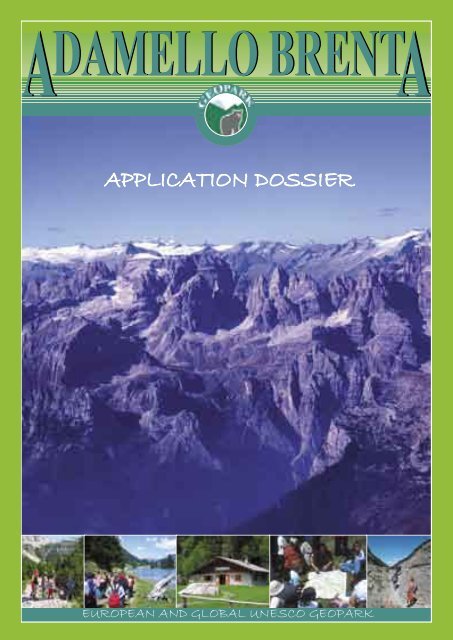
APPLICATION DOSSIER<br />
EUROPEAN AND GLOBAL UNESCO GEOPARK<br />
APPLICATION DOSSIER FOR THE NOMINATION AS EUROPEAN AND GLOBAL UNESCO GEOPARK<br />
1
2<br />
A<br />
A<br />
A A<br />
AA A<br />
A<br />
A A<br />
<strong>DAMELLO</strong> <strong>DAMELLO</strong> <strong>DAMELLO</strong> <strong>DAMELLO</strong> <strong>DAMELLO</strong> <strong>DAMELLO</strong> <strong>DAMELLO</strong> <strong>BRENT</strong> <strong>BRENT</strong> <strong>BRENT</strong> <strong>BRENT</strong> <strong>BRENT</strong> <strong>BRENT</strong> <strong>BRENT</strong>A<br />
<strong>DAMELLO</strong> <strong>DAMELLO</strong> <strong>DAMELLO</strong> <strong>DAMELLO</strong> <strong>DAMELLO</strong> <strong>DAMELLO</strong> <strong>BRENT</strong> <strong>BRENT</strong> <strong>BRENT</strong> <strong>BRENT</strong> <strong>BRENT</strong> <strong>BRENT</strong><br />
<strong>DAMELLO</strong> <strong>DAMELLO</strong> <strong>BRENT</strong> <strong>BRENT</strong><br />
<strong>DAMELLO</strong> <strong>DAMELLO</strong> <strong>BRENT</strong> <strong>BRENT</strong><br />
A A<br />
<strong>DAMELLO</strong> <strong>BRENT</strong><br />
GeoPark<br />
DOSSIER DI CANDIDATURA<br />
EUROPEAN GLOBAL UNESCO GEOPARK<br />
DOSSIER CANDIDATURA A EUROPEAN GLOBAL UNESCO GEOPARK<br />
Museo<br />
Tridentino<br />
Scienze<br />
Naturali<br />
Geological<br />
Service of the<br />
Autonomous<br />
Province of<br />
Trento<br />
1<br />
A <strong>DAMELLO</strong> <strong>BRENT</strong>A<br />
GeoPark<br />
<strong>DAMELLO</strong> <strong>BRENT</strong><br />
A A<br />
GEOPARK<br />
APPLICATION DOSSIER<br />
FOR THE NOMINATION OF<br />
THE TERRITORY OF THE<br />
A<strong>DAMELLO</strong> <strong>BRENT</strong>A<br />
NATURAL PARK AS<br />
EUROPEAN AND GLOBAL<br />
UNESCO GEOPARK<br />
BY:<br />
Violette Masè (<strong>Adamello</strong> <strong>Brenta</strong> Natural Park)<br />
Riccardo Tomasoni (Museo Tridentino Scienze Naturali)<br />
Marco Avanzini (Museo Tridentino Scienze Naturali)<br />
Giorgio Zampedri (Geological Service of the Autonomous Province of Trento)<br />
APPLICATION DOSSIER FOR THE NOMINATION AS AS EUROPEAN AND GLOBAL UNESCO GEOPARK
A <strong>DAMELLO</strong> <strong>BRENT</strong>A<br />
GeoPark<br />
<strong>DAMELLO</strong> <strong>BRENT</strong><br />
A A<br />
GEOPARK<br />
<strong>Adamello</strong> <strong>Brenta</strong> Geopark<br />
A DEFINITION OF THE TERRITORY OF THE EUROPEAN GEOPARK 2<br />
A.1 <strong>Adamello</strong> <strong>Brenta</strong> Geopark 3<br />
A.2 Location 3<br />
A.3 Surface areas – human and geographic elements 3<br />
A.4 Organization in charge of the European Geopark zone<br />
(Ente <strong>Parco</strong> <strong>Adamello</strong> <strong>Brenta</strong>) 4<br />
A.5 Attachments 5<br />
B SCIENTIFIC DESCRIPTION OF THE EUROPEAN AND<br />
GLOBAL UNESCO GEOPARK TERRITORY 6<br />
B.1 Defi nition of the geographical region where the territory is located 7<br />
B.2 General geological description 8<br />
B.2.1 History of geological studies and knowledge 8<br />
B.2.2 Geomorphological and geological description 10<br />
B.2.2.1 A brief picture of the geodynamic evolution<br />
B.2.2.2 Geology of the future <strong>Adamello</strong> <strong>Brenta</strong> Geopark<br />
B.2.2.3 Geomorphology of the future <strong>Adamello</strong> <strong>Brenta</strong> Geopark<br />
B.3 List and description of the geological sites existing on the Geopark territory and<br />
details of their importance (scientifi c, educational, historical, cultural, popular) 16<br />
B.3.1 Glacial and peri-glacial morphologies 17<br />
B.3.2 Karstic morphologies 21<br />
B.3.3 Sites of geological importance 24<br />
B.4 Existing or potential pressure on the territory and on these sites 28<br />
B.5 Existing measures for the preservation of these sites 28<br />
B.6 Data on the management of these sites 30<br />
B.7 List and description of non-geological sites in the territory,<br />
that can be connected to the sites of geological importance 31<br />
B.7.1 Sites of demo-ethno-anthropologic importance 31<br />
B.7.2 Non-geological sites of fl oristic and faunistic importance 34<br />
C ARGUMENTS FOR NOMINATING THE TERRITOTY<br />
AS EUROPEAN AND GLOBAL UNESCO GEOPARK 36<br />
C.1 Comprehensive analysis of the territory for the development of geo-tourism 37<br />
C.2 Overview of the geo-instututions and of the geo-activities existing in the Geopark area 39<br />
C.3 Policy for preservation, enhancement, and economic development<br />
of the existing geological heritage 40<br />
C.4 Interest of the territory to become part of the European<br />
and Global UNESCO Network of Geoparks 41<br />
D GENERAL INFORMATION ABOUT THE TERRITORY 42<br />
D.1 Economic fi eld. Description of the principal structures responsible for the policy<br />
of sustainable development and for the main economic sectors within the territory 43<br />
D.2 Future prospective for territorial protection 45<br />
D.3 Degree of protection of the territory 45<br />
D.4 Existing services 46<br />
D.5 Future services 47<br />
APPLICATION DOSSIER FOR FOR THE THE NOMINATION AS AS EUROPEAN AND GLOBAL UNESCO GEOPARK<br />
3
4<br />
A <strong>DAMELLO</strong> <strong>BRENT</strong>A<br />
GeoPark<br />
A DEFINITION OF THE TERRITORY<br />
OF THE EUROPEAN GEOPARK<br />
APPLICATION DOSSIER FOR THE NOMINATION AS EUROPEAN AND GLOBAL UNESCO GEOPARK
A <strong>DAMELLO</strong> <strong>BRENT</strong>A<br />
GeoPark<br />
A.1 <strong>Adamello</strong> <strong>Brenta</strong> Geopark<br />
The name of the area proposed for inclusion in the<br />
European and Global UNESCO Network of Geoparks<br />
is the “<strong>Adamello</strong> <strong>Brenta</strong> Geopark”. This<br />
area includes the whole territory of the <strong>Adamello</strong><br />
A.2 Location<br />
The area proposed as a Geopark is located<br />
on the west side of Trento Province, in<br />
north-eastern Italy. Located between Valli<br />
Giudicarie, Val di Non, and Val di Sole, the<br />
area includes the Trentino portion of the <strong>Adamello</strong><br />
Presanella Massif and the <strong>Brenta</strong> Dolomites.<br />
Between the two mountain ranges,<br />
which provide the name of the Natural Park<br />
and the future Geopark, is Val Rendena, with<br />
the Sarca river running from north to south.<br />
There are also many side valleys of great<br />
aesthetic and naturalistic value, and thus of<br />
considerable tourist appeal. Particularly worthy<br />
of mention are Val Genova, Val di Tovel,<br />
and Vallesinella, which have access roads<br />
regulated by the Natural Park with special<br />
minibuses that, during summer season, provide<br />
alternative transport for tourists.<br />
The area of the future Geopark is easily accessible<br />
by state road no. 237 from Brescia<br />
The area which is proposed to the European<br />
and Global UNESCO Net of the Geoparks,<br />
includes, as above mentioned, the whole protected<br />
territory of the Natural Park <strong>Adamello</strong><br />
<strong>Brenta</strong>, that involves a total surface of 62052<br />
ha, and the territory that is functionally linked<br />
to it.<br />
The borders of the future <strong>Adamello</strong> <strong>Brenta</strong> Geopark<br />
include a total surface of 114.645,62 ha.<br />
The area proposed as Geopark, includes the<br />
whole administrative territory of the 38 municipalities<br />
of the Natural Park and is totally<br />
included in the Provincia Autonoma of Trento<br />
(Trento Autonomous Administration). The municipalities<br />
are divided into 4 districts: Valle<br />
dell’Adige district (C5, the east side of the Ge-<br />
<strong>Brenta</strong> Natural Park plus an external portion on the<br />
borders of the protected area which includes the<br />
remaining territory of the municipalities partially<br />
located inside the boundaries of the Natural Park.<br />
(70km), or by state road from Trento or<br />
from S. Michele all’Adige, driving for<br />
about 40 km west of the A22 motorway<br />
exit. A good range of main and side roads<br />
is available inside the area: together with a<br />
full range of paths covering the future Geopark<br />
for a distance of 900km. The eastern<br />
and the northern sides of the area are<br />
served by a local railway, the Trento-Malè<br />
line and a bus service linked to the railways<br />
is available.<br />
In a larger scale, the area proposed as European<br />
and Global UNESCO Geopark is<br />
located in a strategic position, on the northsouth<br />
axis that links Italy with Europe.<br />
This is an extremely positive element for<br />
eventual admittance in the European and<br />
Global UNESCO Network of Geoparks,<br />
and also to support the important target of<br />
“establishing a network”.<br />
A.3 Surface areas - human and<br />
geographic elements<br />
opark), Val di Non district (C6, the east side),<br />
Valle di Sole district (C7, the north side) and<br />
Giudicarie district (C8, includes Val Rendena<br />
and the south side of the Geopark), for a total<br />
range of 41603 inhabitants (2006).<br />
The populated areas are completely external to<br />
the protected area, located on the valley floors<br />
where there is the main population density.<br />
During the tourist season (summer and winter),<br />
the north side of Val Rendena, that has a<br />
strong tourist appeal, and some areas in Val di<br />
Sole and on the Paganella upland, are subjected<br />
to a big increase of population. (for a deeper<br />
investigation concerning the economy of the<br />
area see paragraph D.1; for the geographic<br />
description see paragraph B.1).<br />
APPLICATION DOSSIER FOR THE NOMINATION AS EUROPEAN AND GLOBAL UNESCO GEOPARK<br />
5<br />
A
6<br />
The request for admission to the<br />
European and Global UNESCO<br />
Network of Geoparks is presented<br />
by the <strong>Adamello</strong> <strong>Brenta</strong> Park Authority,<br />
a functional body of the<br />
Provincia Autonoma di Trento (Autonomous<br />
Province of Trento). It<br />
enjoys full legal status in public law,<br />
instituted in 1988 with the provincial<br />
law 6.5.88, n.18: “Natural Parks<br />
Regulations”. The <strong>Adamello</strong> <strong>Brenta</strong><br />
Park Authority manages the largest<br />
protected area in Trentino, the<br />
<strong>Adamello</strong> <strong>Brenta</strong> Natural Park, with<br />
its 620.52 square kilometers. The<br />
bodies of the Authority comprise:<br />
Management Committee, Executive<br />
Committee, the President, the<br />
Director and the Audit Staff.<br />
The purpose of the Natural Park,<br />
defined in the first article of the<br />
provincial law, is “The protection<br />
of natural and environmental characteristics,<br />
the promotion of scientific<br />
study, and the social use of<br />
environmental resources”. Thanks<br />
to this purpose, the Natural Park<br />
has promoted an active protection<br />
A <strong>DAMELLO</strong> <strong>BRENT</strong>A<br />
GeoPark<br />
European Geopark zone<br />
(Ente <strong>Parco</strong> <strong>Adamello</strong> <strong>Brenta</strong>)<br />
of the environment, the spreading<br />
of an environmental culture, and<br />
sustainable development of local<br />
communities since its institution.<br />
In order to achieve these targets, in<br />
recent years the Natural Park has<br />
promoted numerous projects, under<br />
the following strategic lines:<br />
• Environmental and Biodiversity<br />
Protection: with the protection<br />
of species and habitats, not only as<br />
an institutional duty, but also as an<br />
opportunity for economic and civil<br />
improvement for the population,<br />
representing an additional value for<br />
the territory.<br />
• Territorial Maintenance and<br />
Landscape Protection: the Authority<br />
devotes substantial logistic<br />
and financial resources in order to<br />
achieve this target, being aware that<br />
a well managed territory becomes a<br />
fundamental resource, also for appropriate<br />
and lasting development.<br />
• Scientific Research: fundamental<br />
for the enrichment of collective<br />
knowledge, the Natural Park<br />
assigns special importance to this<br />
Excursion in the future Geopark – Photo Archive Pnab A.4 Organization in charge of the<br />
functional aspect, in terms of stimulations<br />
and ideas, as guidelines for<br />
steering its decisions.<br />
• Environmental Education: a<br />
very important target, increasing<br />
daily and becoming for the Natural<br />
Park an extraordinary means for<br />
spreading its culture and its deepest<br />
sense. This is closely tied to the<br />
training, that increases professionalism<br />
and competence, creating a<br />
high level occupational opportunity<br />
as part of the social and economic<br />
development for territorial<br />
protection.<br />
• Territorial Improvement: referring,<br />
besides the landscape and<br />
environmental qualities, to the aspects<br />
concerning the culture, tradition,<br />
and history, all basic elements<br />
of territorial identity.<br />
• Sustainable Development: in order<br />
to become a model and involve<br />
local communities in singling out<br />
new paradigms for the Human-Territory-Economic<br />
Improvement chain.<br />
The projects regarding sustainable<br />
mobility and energy conservation<br />
are important in this respect.<br />
It is necessary to add, to these six<br />
strategic targets, three main values,<br />
that affect the way the Natural Park<br />
works:<br />
• Participation: necessary requirement<br />
and main condition for the<br />
sustainability of the development.<br />
The Natural Park has promoted<br />
strategies, in agreement and with<br />
the support of local communities,<br />
as per the European Charter for<br />
Sustainable Tourism obtained in<br />
2006. Participation extends outside<br />
its territorial limits, aiming to<br />
establish strategic alliances for a<br />
global environmental policy.<br />
• Communication: as the ability to<br />
spread ideas and initiatives in order<br />
to demonstrate the importance and<br />
the utility of the Park, an in order<br />
to transmit values and appropriate<br />
APPLICATION DOSSIER FOR THE NOMINATION AS EUROPEAN AND GLOBAL UNESCO GEOPARK
Flavona Mountain Hut – Photo V. Masè<br />
behaviour patterns.<br />
• Quality: as a philosophy and<br />
working method that must inform<br />
every action of the Park, with the<br />
objective of extending this kind of<br />
purpose to the surrounding territory<br />
and to users, making them aware<br />
of it. First Park in Europe to obtain<br />
ISO 14001 certification (in 2001),<br />
since 2006 the Park is registered as<br />
EMAS.<br />
The strategic purposes, together<br />
with their values, are realized<br />
thanks to the many projects that the<br />
Park promotes with constant and<br />
coherent activity, being aware of<br />
the possibility of uniting the necessities<br />
of protection, research, and<br />
education with those of increasing<br />
and sustainable development.<br />
IDENTITY CARD OF THE A<strong>DAMELLO</strong><br />
<strong>BRENT</strong>A NATURAL PARK<br />
• Authority: <strong>Adamello</strong> <strong>Brenta</strong><br />
Park Authority<br />
• Administrative office: Via Nazionale,<br />
24 – I 38080 Strembo -<br />
ITALY<br />
• Tel: +39 0465 80 66 66<br />
• Fax: +39 0465 80 66 99<br />
A.5 Attachments<br />
Attachment 1:<br />
Map, list and description of geosites.<br />
A <strong>DAMELLO</strong> <strong>BRENT</strong>A<br />
GeoPark<br />
• Web site: http://www.pnab.it/<br />
• E-mail: mailto:info@pnab.it<br />
• Province: Trento<br />
• Municipalities (39): Andalo,<br />
Bleggio Inferiore, Bocenago,<br />
Breguzzo, Caderzone, Campodenno,<br />
Carisolo, Cavedago, Cles,<br />
Commezzadura, Cuneo, Daone,<br />
Darè, Denno, Dimaro, Dorsino,<br />
Flavon, Giustino, Massimeno,<br />
Molveno, Monclassico,. Montagne,<br />
Nanno, Paspardo (Brescia<br />
province), Pelugo, Pinzolo, Ragoli,<br />
San Lorenzo in Banale, Spiazzo,<br />
Spormaggiore, Sporminore,<br />
Stenico, Strembo, Tassullo, Terres,<br />
Tione, Tenno, Vigo Rendeva, Villa<br />
Rendeva.<br />
• Instituted with Provincial law<br />
no. 18 of 6 th of May 1988.<br />
• Park Plan: approved with the<br />
deliberation of the provincial<br />
committee no. 6266 of 23 rd of July<br />
1999.<br />
• Management Committee: 69<br />
members; 39 are municipalities,<br />
20 are main local bodies (Districts,<br />
ASUC, Comunità delle Regole<br />
Spinale e Manez), 10 are divided<br />
between Services of the Provincia<br />
Autonoma di Trento (Autonomous<br />
Province of Trento), Museum Tridentino<br />
of Natural Science, and<br />
other associations.<br />
• Executive Committee: 11 members;<br />
8 are representatives of the<br />
local communities and 3 are representatives<br />
of the Provincial Services:<br />
Antonello Zulberti (president),<br />
Paolo Ciardi (vice-president),<br />
Daniele Bolza, Federico Brunelli,<br />
Nicola Campidelli, Antonio Caola,<br />
Michele Cova, Alberto Flaim,<br />
Ugo Pellizzari; as provincial representatives:<br />
Giuseppe Sevignani,<br />
Lucio Sottovia, Roberto Zoanetti.<br />
• Director: Claudio Ferrari<br />
Referring person:<br />
Name: Claudio Ferrari<br />
Role: Director<br />
Authority: <strong>Adamello</strong> <strong>Brenta</strong> Park<br />
Authority<br />
Address: Via Nazionale, 24<br />
Town and Postcode: Strembo<br />
(TN), I - 38080<br />
Nation: Italy<br />
Tel:+39 0465 80 66 66<br />
Fax:+39 0465 80 66 99<br />
mailto: Claudio.Ferrari@pnab.it<br />
Attachment 2:<br />
Supporting letter of the local bodies (Municipalities,<br />
APT – Tourist Promotion Agency, SAT – Tridentina<br />
Alpinists Society, and other involved bodies).<br />
APPLICATION DOSSIER FOR THE NOMINATION AS EUROPEAN AND GLOBAL UNESCO GEOPARK<br />
School activities in the future Geopark<br />
7<br />
A
8<br />
A <strong>DAMELLO</strong> <strong>BRENT</strong>A<br />
GeoPark<br />
B SCIENTIFIC DESCRIPTION OF THE<br />
EUROPEAN AND GLOBAL GLOBAL UNESCO<br />
GEOPARK TERRITORY<br />
APPLICATION DOSSIER FOR THE NOMINATION AS EUROPEAN AND GLOBAL UNESCO GEOPARK
A <strong>DAMELLO</strong> <strong>BRENT</strong>A<br />
GeoPark<br />
B.1 Definition of the geographical region<br />
where the territory is located<br />
The area proposed as Geopark is<br />
located on the Retiche Alps, in the<br />
mid-southern Italian sector of the<br />
Alpine Range, including within its<br />
borders the Trentino portion of the<br />
<strong>Adamello</strong>-Presanella range and the<br />
whole <strong>Brenta</strong> Dolomitesrange .<br />
The core of the future Geopark is<br />
constituted by these two mountain<br />
ranges that, thanks to their uniqueness<br />
and geological-naturalistic<br />
peculiarities, represent its main elements.<br />
To this extended territorial<br />
portion, included in the <strong>Adamello</strong><br />
<strong>Brenta</strong> Natural Park, it is necessary<br />
to add wide ramifications of the<br />
<strong>Adamello</strong> and <strong>Brenta</strong> to achieve a<br />
total dimension of 114,645.62 ha.<br />
This would mean substantially<br />
increasing the dimensions of the<br />
existing protected area. While the<br />
“administrative” borders of the<br />
Geopark seem to be “frayed”, the<br />
physical and geographical ones are<br />
based on well defined morphological<br />
and structural elements that coincide<br />
with the main valleys of the<br />
area. This can be seen by looking<br />
at the external perimeter of the 38<br />
municipalities involved in the Natural<br />
Park. These valleys represent<br />
the structural grid that has guided<br />
the shaping of this territory, located<br />
where the structural NE-SW group<br />
of the Giudicarie district, crosses<br />
the Insurbic line with an E -W orientation.<br />
The north-eastern limits of the future<br />
Geopark are represented by<br />
the two valley axes followed by the<br />
Noce river, one of the main affluents<br />
of Adige river. These are the<br />
Val di Sole, which from 1880 mt.<br />
a.s.l. (Passo del Tonale) descends<br />
with a E-W orientation to the Stretta<br />
di Mostizzolo (594 mt. a.s.l.),<br />
and the Val di Non, that from this<br />
point defines, with an eastern orientation,<br />
the north-eastern portion<br />
of the <strong>Brenta</strong> Dolomites.<br />
The south-eastern borders are de-<br />
limited by the north-south orientated<br />
depression, containing Lake<br />
Molveno, and by the Upper Valli<br />
Giudicarie, followed in this area E-<br />
W, by the Sarca river.<br />
The south-western portion borders<br />
on Val di Fumo and on Valle di<br />
Daone.<br />
The west border of the future Geopark<br />
is the N-S ridge that divides<br />
Val di Fumo from Valle di Adamè;<br />
it coincides with the administrative<br />
limits of the Provincia Autonoma<br />
di Trento and the <strong>Adamello</strong> <strong>Brenta</strong><br />
Natural Park.<br />
Extensive mountain ranges surround<br />
this territory, in particular<br />
the impressive Ortles-Cavedale<br />
range, to the north of Val di Sole,<br />
and the Paganella-Monte Gazza<br />
range to the east.<br />
The area proposed as Geopark is<br />
distinguished by its rigorously<br />
mountainous morphology, with<br />
ridges separated by deep incisions,<br />
flowing into the main valleys. An<br />
example is Val Rendena which,<br />
with its NE-SW course, separates<br />
two contrasting geological and geomorphological<br />
“worlds”: the <strong>Adamello</strong>-Presanella<br />
and the <strong>Brenta</strong><br />
Dolomites. Its flanks are intersected<br />
by wild tributary valleys, (Val di<br />
Borzago, Val S. Valentino, Val di<br />
Genova, Val <strong>Brenta</strong>, Valagola).<br />
There are numerous peaks of above<br />
3000 m, with Cima Presanella the<br />
highest peak in the Geopark at<br />
3558 m, Crozzon di Lares (3406<br />
m), Carè Alto (3563 m) and, in<br />
the <strong>Brenta</strong> Dolomites, Cima Tosa<br />
(3159 m), Cima <strong>Brenta</strong> (3150 m).<br />
and Crozzon di <strong>Brenta</strong> (3135 m).<br />
In contrast with the peaks and ridges<br />
that dominate the <strong>Brenta</strong> and <strong>Adamello</strong><br />
Presanella ranges, there are<br />
the gentler, more rolling features of<br />
the morphological terraces of Val<br />
di Non, Bleggio, and Banale. These<br />
features represent the eastern and<br />
south-eastern limits of the future<br />
Geopark.<br />
From the heart of the two mountain<br />
ranges flows the Sarca river, formed<br />
from the union of the tributaries of<br />
Nambrone, Genova, and Nambino,<br />
that are fed by the the glaciers of<br />
<strong>Adamello</strong>-Presanella and by the<br />
Vallesinella tributary, that gushes<br />
out from the karst springs of <strong>Brenta</strong>.<br />
The Sarca, a tributary of Garda<br />
Lake, before entering into the<br />
most extended Italian river system,<br />
runs through the whole of<br />
Val Rendena and, when it reaches<br />
the Conca di Tione, diverts to the<br />
east flowing into a deep curving<br />
gorge, before flowing south into<br />
the “Sarca”valley and finishing its<br />
course near Torbole sul Garda.<br />
The Chiese river is the second main<br />
water course of the area arising<br />
from the Lobbia glacierand running<br />
the entire length of Val di Fumo and<br />
Valle di Daone before entering into<br />
Lake Idro.<br />
The area proposed as Geopark is<br />
an extremely articulated and diversified<br />
zone, withthe spectacular<br />
uniqueness of its mountain landscapes<br />
at its heart and the remarkable<br />
geological and geomorphological<br />
diversity of the two mountain<br />
ranges that dominate it. The peculiarities<br />
and diversities of the bordering<br />
sectors are distinctive and<br />
characterizing factors that in the<br />
past had a dermining influence on<br />
the lives of the people in these areas.<br />
This interaction underlines the<br />
indissoluble union between human<br />
activities and their geological-environmental<br />
context.<br />
APPLICATION DOSSIER FOR THE NOMINATION AS EUROPEAN AND GLOBAL UNESCO GEOPARK<br />
9<br />
B
10<br />
At the beginning of 19th century,<br />
Geology was an established Science.<br />
Many scholars studied the valleys in<br />
order to discover the mechanisms that<br />
had formed so many varied and dramatic<br />
landscapes. In 1836 the “Mineralogisch-geognostische<br />
Verein in<br />
Tirol” (Tirol mineralogy and geology<br />
Association) was established,<br />
the third geological association after<br />
London (1870), and Paris (1830). A<br />
few years later, in 1849, the “Wien<br />
Imperial Geology Institute” was established,<br />
and in a short time this city<br />
A <strong>DAMELLO</strong> <strong>BRENT</strong>A<br />
GeoPark<br />
B.2.1 HISTORY OF GEOLOGICAL STUDIES AND KNOWLEDGE<br />
had became the centre of Geological<br />
Research for South-Tirol.<br />
In the second half of the 1800s Ferdinand<br />
Freiher von Richthofen, worked<br />
out one of the boldest theories of the<br />
History of Geological Research: the<br />
theory that the tropical cliffs in the<br />
South Seas and parts of the Dolomite<br />
Mountains, would have had the same<br />
origin: corals, sponges, alga, and<br />
other sea animals had created rocky<br />
elements that later rose from the sea<br />
floor.<br />
Richthofen was convinced that a large<br />
Geological Map of <strong>Brenta</strong> Dolomites – Trevisan, 1939 B.2 General geological description<br />
part of the most important changes in<br />
the formation of the Dolomites were<br />
traceable to some slow movements of<br />
the earth’s crust and to a slow lowering<br />
of the sea floor and consequent<br />
rising of the reef. While Richthofen<br />
was working in the eastern Dolomites,<br />
H.Wolf (1856-57), R.Lepsius<br />
(1875-78), G. Stache (1879), and Bittner<br />
(1881,1883), began to explore<br />
the mountains in Val di Non and in<br />
Val di Sole, examining their many<br />
interesting features and considering<br />
how those valleys might represent<br />
a key zone for the union of eastern<br />
Trentino with the Lombardia area<br />
(west), where, in the same period, the<br />
first Italian geologists were beginning<br />
their activity.<br />
The first specific studies on the <strong>Adamello</strong>-<strong>Brenta</strong><br />
Range, are attributed<br />
to Gumbel who, around 1870, began<br />
his studies on the Mendola walls and<br />
on the <strong>Brenta</strong> Range, in order to relate<br />
them with the Dolomites Peaks.<br />
In the same years Richthofen concludes<br />
that these territories had a<br />
similar geological history.<br />
A few years later, G. Loss used the<br />
data of the Geologists of the Wien<br />
Federal Geological Institute and added<br />
it to his own, in order to describe<br />
the geological history of Val di Non.<br />
These studies are, overall, still valid.<br />
The studies of M. Vaceck and W.<br />
Hammer are older still, and aimed to<br />
realize the “Geologische Spezialkarte<br />
der Osterreichische-Ungarischen<br />
Monarchie”, published in 1903 (scale<br />
1:75,000).<br />
The approach to the study of the glacial<br />
and morphological environment<br />
of the Park was different, and began<br />
with the start of mountaineering on<br />
the <strong>Adamello</strong> and <strong>Brenta</strong> Ranges,<br />
even if several authors have already<br />
named these mountain landscapes as<br />
early as 1700 (Roschmann, 1738).<br />
The first citations of the Mandrone<br />
and Lobbia glaciers are found in the<br />
1800s (Suda, Merciai,1925).<br />
It was only after the conquest of<br />
Cima <strong>Adamello</strong> by Julius Payer that<br />
APPLICATION DOSSIER FOR THE NOMINATION AS EUROPEAN AND GLOBAL UNESCO GEOPARK
it was possible to see the first cartographic<br />
descriptions of the massif’s<br />
glaciers.<br />
The valuable cartographic surveys<br />
that describe most of the main glaciers<br />
in the <strong>Adamello</strong> range are attributed<br />
to Payer (1863), Sonklar,<br />
Loretz, and Richter.<br />
After a break during to the First World<br />
War, Schubert started his studies on<br />
foraminifers of the Mesozoic formation,<br />
and Salomon, Heiritsh, Spitz,<br />
and Klebersberg outlined a general<br />
stratigraphic and structural picture<br />
of the area. J.Pia extended his studies<br />
on Triassic formations in the Dolomites<br />
to the Ranges located on the<br />
west side of Valle dell’Adige. On the<br />
strength of this work he confirmed<br />
Richthofen’s intuitions. When these<br />
territories become Italian, the Italian<br />
geologists also started studying this<br />
area. The first studies were probably<br />
by Fabiani, dealing with the Tertiary<br />
features in Val di Non. This was the<br />
forerunner for the surveys of the new<br />
geological maps (scale 1:100,000)<br />
of the Italian Geological Service. At<br />
the beginning of the 30’s, Trevisan<br />
worked on a monumental monograph<br />
about the <strong>Brenta</strong> Range, published<br />
in 1939. The author established the<br />
main geological formations, that are<br />
still accepted, and underlined the<br />
clear diversity between the right side,<br />
completely included within the Massif,<br />
and the remaining section of Val<br />
di Non, with its own characteristics.<br />
In the same years, the new scientific<br />
understanding of structural geology,<br />
led to further investigation regarding<br />
the tectonic aspects of this area.<br />
In the same period the possibility<br />
of defining with close precision the<br />
nature of the intrusive rocks of the<br />
<strong>Adamello</strong> Range, and the possibility<br />
of correctly defining them in a<br />
chronological and evolutionary perspective<br />
become realistic. In the 50’s<br />
the first studies on natural radioactivity<br />
began in some sectors (ex. Val<br />
Genova) and the first explorations in<br />
order to find uranium mineralisations<br />
in the southern sector of <strong>Adamello</strong><br />
(Val di Daone).<br />
In the same period the studies on<br />
glaciers were continuing, highlighting<br />
the variations of the glacial<br />
mass, and suggesting research into<br />
A <strong>DAMELLO</strong> <strong>BRENT</strong>A<br />
GeoPark<br />
the mechanisms that, clearly, were<br />
leading to a progressive contraction<br />
of the glaciers (Merciai, Morandini,<br />
Castiglioni). In the second half of<br />
the 1900s, constant monitoring activity<br />
began by the Italian Glaciologic<br />
Committee, at the same time with<br />
the regular studies, which are supported<br />
by the Park. The information<br />
acquired (frontal measurements and<br />
pictures), have become an important<br />
database that is held at the headquarter<br />
of the Trento Alpine Club (SAT).<br />
After this first step, long term monitoring<br />
activities were instigated, with<br />
the aim of studying the main characteristics<br />
and distribution of rock glaciers<br />
in the Park area. Again in the<br />
50’s, the superficial water resources<br />
became a subject of study, to plan<br />
hydroelectric plants on the massifs<br />
surrounding the valleys. Almost simultaneously<br />
studies began on Karst<br />
formations in the carbonate massifs.<br />
These studies underlined, firstly the<br />
great potentialial of this scientific<br />
field, and, secondly, they analyse in a<br />
detailed way the karst formations as<br />
they were identified.<br />
The beginning of the 60’s saw the<br />
first absolute dating of <strong>Adamello</strong><br />
tonolite rocks, a process that was<br />
continued in later years and refined<br />
in recent times.<br />
In the 70’s and 80’s the basic knowl-<br />
edge of the geological structure of<br />
the territory was established. Attention<br />
was concentrated to achieving<br />
detailed descriptions on specific aspects<br />
of particular geographic zones.<br />
From the 80’s onwards, attention was<br />
given to the geology and geomorphology<br />
of the Quaternary period,<br />
with the creation of detailed geomorphological<br />
maps of <strong>Adamello</strong>, and<br />
the reconstruction of the modelling<br />
processes that had transformed the<br />
area into its present form.<br />
Today this extended area undergoing<br />
surveying in order to produce new<br />
maps for the Provincia Autonoma di<br />
Trento geological survey (National<br />
Project CARG).<br />
These studies have provided a con-<br />
vincing description of the processes<br />
that shaped the present day territory,<br />
with the merit of exhaustively covering<br />
all the geological aspects of the<br />
area. Also worthy of note is the work<br />
carried out for the creation of a map<br />
for the educational landscapes of the<br />
whole Park area, thanks to the cooperation<br />
between the <strong>Adamello</strong> <strong>Brenta</strong><br />
Natural Park and the Museo Tridentino<br />
Scienze Naturali; the studies on<br />
Rock glaciers with the collaboration<br />
of the SAT Glaciological Committee,<br />
and the recent studies into deep water<br />
circulation promoted by the Museum<br />
and Trento Province.<br />
APPLICATION DOSSIER FOR THE NOMINATION AS EUROPEAN AND GLOBAL UNESCO GEOPARK<br />
Lobbia and Mandrone Glaciers, as in J. Payer topographic map, 1965 B<br />
11
12<br />
A <strong>DAMELLO</strong> <strong>BRENT</strong>A<br />
GeoPark<br />
B.2.2 GEOMORPHOLOGICAL AND GEOLOGICAL DESCRIPTION<br />
The territory proposed as a European<br />
and Global UNESCO Geopark covers<br />
a key area in north-west Trentino,<br />
characterized by the presence of the<br />
tectonic border between the Austroalpine<br />
and Southern Alps, and by<br />
the union of three segments of the Periadriatic<br />
Alignment (Salomon, 1910;<br />
Dal Piaz e Bianchi, 1934; Exner, 1976;<br />
Schmid and others, 1989; Bigi and<br />
others, 1990). The territory extends to<br />
the northern limit of Southern Alps,<br />
in contact near Tonale with the internal<br />
area of the Alpine orogenic prism<br />
of European vergence, represented by<br />
Upper Austroalpine units. Both cases<br />
involve continental crust derived from<br />
the passive edge of the Adriatic plate,<br />
inverted during the alpine orogenesis,<br />
the Austroalpine close to the Mesozoic<br />
ocean, and the Southern Alps in a distal<br />
position. During the middle to upper<br />
Oligocene the Periadriatic Alignment<br />
generated the uplifting of this section<br />
of the chain, exposing the deep Austroalpine<br />
crust to erosion.<br />
In the area described above , the Southern<br />
Alps are divided into two different<br />
blocks, bordered by the fault system of<br />
Bacinal Triassic Succession – Photo R. Tomasoni<br />
the Giudicarie and Sabion, with NNE<br />
orientation, and characterized by contrasting<br />
lithologies:<br />
• In the eastern lowered block, the<br />
Mesozoic coverage of the <strong>Brenta</strong> Dolomites<br />
and the Insubrico Flysch.<br />
• In the western raised block, the Baiolite<br />
of <strong>Adamello</strong>, with the oligogenic<br />
plutons of Presanella and Nambrone,<br />
the metamorphic base, some intrusive<br />
Permian bodies and few shards of the<br />
original Permo-Triassic coverage.<br />
B.2.2.1 A BRIEF ANALYSIS OF THE<br />
GEODYNAMIC EVOLUTION<br />
The existing units of the Park territory<br />
and of the surrounding areas are proof<br />
of a long and complex geological evolution<br />
originating in the Lower Paleozoico.<br />
The main stages can be traced<br />
to the pre-Alpine orogenesis, the long<br />
phase of lithospheric extension that<br />
created the passive Adriatic margin,<br />
and the Alpine orogenesis, started<br />
during the Creatico and still underway<br />
(neotectonic, seismicity).<br />
The Austroalpine base rising on the<br />
North side of Tonale, outside the Park<br />
borders, contains a mafic-ultramafic<br />
metamorphites complex,<br />
which could represent,<br />
overall, the remains of<br />
an old pre-ercinic ocean<br />
(ophiolites) (Neubauer,<br />
1988), subducted and<br />
deformed in a mountain<br />
chain during the Ordovician.<br />
The collapse of this mountain<br />
chain (ercinic), caused<br />
by a progressive thinning<br />
of the lithosphere, began at<br />
the end of Carboniferous<br />
and increased during the<br />
Permian, (Piaz&Martin,<br />
1998). The lithospheric<br />
extension continued until<br />
the development of the<br />
Noric-Jurassic continental<br />
rifting . This crucial<br />
phase of the development<br />
of the pre-oceanic Tetide<br />
is well documented by the<br />
Mesozoic coverage of the<br />
<strong>Brenta</strong> Range, located in<br />
a transitional area within<br />
some sedimentary-suc-<br />
cessions of habitat with different batimetries.<br />
In this area the Mesozoic<br />
facies indicate a rapid passage from an<br />
structural rise Trento Platform), and a<br />
basin area (Lombardy Basin) (Aubuoin,<br />
1963), under the strict control<br />
of the sin-sedimentary faults. (Castellarin,1972,1082;<br />
Gaetani, 1975).<br />
During the Triassic, but particularly<br />
during the extensional evolution of the<br />
Noric-Liassic rift, the Giudicarie lines<br />
and the Sabion line, could have had an<br />
important role. The north oriented continuation<br />
of the Ballino Garda tectonic<br />
scarp, is clearly recognizable along<br />
the west side of the <strong>Brenta</strong> Range.<br />
The line of the Vedretta dei Camosci,<br />
during the Lower Jurassic, borders to<br />
the east the succession in carbonate<br />
platform facies, separating them from<br />
the contemporary ones, characterized<br />
by a basinal habitat, and appearing<br />
on the western side of Val Meledrio.<br />
On the eastern side of Monte Spolverino,<br />
there are traces of exposures of<br />
the Tofin Formation, with its typical<br />
associations of limestones flintstones<br />
and calcium torbidites and voluminous<br />
bodies of mega-breccia (Castellarin<br />
and others, 1993). Moreover, the<br />
Jurassic rifting controlled the distribution<br />
of facies of Grey-limestones.<br />
Between the Batonian and Lower Cretaceous,<br />
the events regarding the genesis<br />
of the oceanic crust in the Alpine<br />
Tetide and its expansion followed<br />
the rifting phase, with the consequent<br />
drifting of its continental margins that<br />
consequentially plunged.(Winter and<br />
Bosellini,1981). The stop in production<br />
of low-depth sediments in the<br />
platform areas and the improvement<br />
of batimetries in the basinal areas, are<br />
in fact proved by the emergence of<br />
bathypelagic facies, like the Ammonitic<br />
Red on the platform and the radiolarites<br />
on the basinal areas, followed<br />
by common successions of Majolica<br />
with a remarkable gap in their layers,<br />
passing from the zones of old platform<br />
to the basinal ones.<br />
In the Upper Cretaceous, the most<br />
extreme expression of the sin-sedimentary<br />
tectonism is represented by<br />
the contraposition of the terrigenous<br />
facies with the carbonate facies along<br />
the west limits of the <strong>Brenta</strong> Range<br />
APPLICATION DOSSIER FOR THE NOMINATION AS EUROPEAN AND GLOBAL UNESCO GEOPARK
Outctop of Megalodon – Photo M. Zeni<br />
(Doss del Sabion area) and, to the<br />
north, along the western side of the<br />
Giudicarie Line (Val di Sole and Val<br />
di Rumo). In order to explain this<br />
kind of contraposition, some direct<br />
sin-sedimentary faults with a medium<br />
angled immersion to the west were<br />
identified (Castellarin and others,<br />
1976). These kind of structures have<br />
controlled the sedimentary evolution<br />
of the area, creating the contrasting<br />
stratigraphic situation. Moreover,<br />
they had a significant palaeographic<br />
role, as they separated the leading<br />
trench of the neo-Alpine mountain<br />
chain and its accumulation of Insurbic<br />
Flysch (Val d’Agola) in the area<br />
of Samoclevo – Val di Sole, from the<br />
rise of the nearby platform, where the<br />
Scaglia Rossa, well recognizable in<br />
the area of Cles, was deposited at Tuenno<br />
(Castellarin and others, 1993).<br />
This kind of extending regime , has to<br />
be inserted in the orogenesis context<br />
in the face of an advancing chain, so<br />
the local direct faults are themselves<br />
expression of this kind of structural<br />
picture. The developing regime of peripheral<br />
bulging, in this area, was preceded<br />
in some cases and for a limited<br />
period, by a weak basinal inversion<br />
along the old Jurassic faults, as highangle<br />
compressive through currents<br />
(Sasso Rosso-M Peller-Val d Non (Picotti<br />
and others, 1988)).<br />
The alpine orogenesis started during<br />
the Cretacious, involving the Aus-<br />
A <strong>DAMELLO</strong> <strong>BRENT</strong>A<br />
GeoPark<br />
troalpine domination of the Adriatic<br />
continental margin. The progressive<br />
subduction of the Pennidic ocean<br />
(eastern extension of the Ligurian-<br />
Piedmont ocean) proceeded into the<br />
Eocene, generating acretion of ophiolitic<br />
units with eclogitic metamorphism<br />
or blue schist facies at the base<br />
of the Austroalpine fault prism and,<br />
finally, their collision with the European<br />
continental margin, represented<br />
by the Pennidic base faults and cover<br />
exhumed in the Hohe Tauern windowand<br />
other more external units.<br />
The cold regime led by subduction<br />
has changed into normal or warm<br />
conditions, due to the continental<br />
collision and, maybe to the rising of<br />
warm asthenosphere, made easier<br />
by a possible detachment<br />
of the subducted<br />
oceanic lithosphere.<br />
These new thermal<br />
conditions produced<br />
a recrystallization of<br />
the collision prism, accompanied<br />
by remarkable<br />
ductile deformations.<br />
The genesis of<br />
peri-Adriatic magmatism,<br />
that exploded in<br />
the Olgocene (around<br />
30-31 Moy) after the<br />
Eocenic symptoms, is<br />
due to the same tectonic-thermal<br />
causes,<br />
and is attributed only<br />
to southern <strong>Adamello</strong> and probably<br />
linked to favourable local tectonic<br />
conditions.<br />
The long tectonic history, along the<br />
NNE lines (southern Giudicarie Line)<br />
and along the EW oriented transfers<br />
(Tonale Line), seems to have been<br />
very important as regards the settling<br />
of the batholite on <strong>Adamello</strong>, whose<br />
triangular shape could be interpreted<br />
as the expression of this origin. The<br />
batholite, composite and polygenic,<br />
developed between 42 and 29 million<br />
years ago (Del Moro and others,<br />
1985; Martin and others, 1996), that<br />
is, between the end of middle Eocene<br />
and the beginning of Cattian, quite<br />
calm period in the orogenesis of the<br />
SouthernAlps.<br />
APPLICATION DOSSIER FOR THE NOMINATION AS EUROPEAN AND GLOBAL UNESCO GEOPARK<br />
Megalodon (Noric Dolomia) – Photo R. Trevisan<br />
Megalodon, Noric Dolomia – Photo E. Guella B<br />
13
Scaglia Rossa – Photo R. Tomasoni<br />
14<br />
B.2.2.2 GEOLOGY OF THE FUTURE<br />
A<strong>DAMELLO</strong> <strong>BRENT</strong>A GEOPARK<br />
As mentioned, the territory could be<br />
divided into two big sectors:<br />
• The eastern block, with its Mesozoic<br />
coverage of the <strong>Brenta</strong> Dolomites<br />
• The western block with the <strong>Adamello</strong><br />
Batholite, the metamorphic base,<br />
some intrusive Permian bodies and<br />
few shards of the original Permo-Triassic<br />
coverage.<br />
1) <strong>Brenta</strong> Area<br />
The oldest units of the eastern area of<br />
the future Geopark are volcanic-sedimentary<br />
deposits of the Lower Permian;<br />
they consist of lava, ignimbrites<br />
and pyroclastics, with intercalations<br />
of river-lake deposits, that can be explained<br />
as refilling products of a big<br />
basin near Tione (Cassinis and others,<br />
1982). Usually the percentage of riverlake<br />
deposits increases towards the<br />
North, achieving its maximum in the<br />
area near Massimeno.<br />
Basically, the volcanic succession of<br />
the Lower Premian (appearing in Val<br />
Rendena), could be divided into a lower<br />
unit, consisting of lava and pyroclasts,<br />
and a upper unit, where ignimbrites are<br />
prevalent (Bargossi and others, 1993;<br />
Cortesogno and others, 1998).<br />
Some clastic deposits of the Upper<br />
Premian (Verrucano Lombardo and<br />
Arenaria di Val Gardena) follow this<br />
succession. These deposits are well exposed<br />
on the South-East sector of the<br />
<strong>Brenta</strong> Range (Massimeno and Malga<br />
Plan, Val d’Algone, between Malga<br />
A <strong>DAMELLO</strong> <strong>BRENT</strong>A<br />
GeoPark<br />
Movlina and Malga Stablei).<br />
The Lower Triassic units are chiefly<br />
represented in western (Val Rendena)<br />
and in the south-western areas,<br />
the closest coverage to the Giudicarie<br />
Line. They are typical associations in<br />
“facies lombarda”, not existing in the<br />
eastern sector, or, if existing, characterized<br />
by other facies, generally of the<br />
“Venetian” or “transitional” type. The<br />
Werfen Formation well visible from<br />
Ragoli and Val d’Algone (on the south<br />
side of Malga Stablei) is a clearly recognizable<br />
exception that, despite its<br />
smallness, shows some gaps that are<br />
similar to the ones of the Dolomites;<br />
this exception is valid for the conglomerate<br />
of Richthofen in Val Perse.<br />
In the area of the Tione basin units are<br />
clearly shown, as the Prezzo Limestone,<br />
a formation represented by dark<br />
micritic limestones with ammonite<br />
moulds (Cima Durmont), and thick<br />
insertions of grey-green or yellow<br />
marly clay that have a volcanic origin<br />
(Buchestein).<br />
The sedimentary successions of the<br />
middle sector of the <strong>Brenta</strong> Range<br />
rest on middle Triassic formations, on<br />
Contrine limestone and on the Sciliar<br />
Formation, a succession of dolostones<br />
of the Upper Anisico Age – Ladinico,<br />
well exposed on the internal sides of<br />
<strong>Brenta</strong> Range (Val <strong>Brenta</strong> Alta, Rifugio<br />
Casinei, Val Perse). Above them,<br />
in the Middle <strong>Brenta</strong> Range sector<br />
(Val <strong>Brenta</strong> Alta, Rifugio Brentei, Val<br />
Perse) a succession of almost one hundred<br />
meters of dolostone and dolom-<br />
itic flinty limestones has been referred<br />
to the Breno Formation of Upper Triassico<br />
Age.<br />
The Dolomia Principale is a typical<br />
formation of platform – dolostones,<br />
constiting of a monotonic succession<br />
of peritidial cycles (Bosellini &Hardie,<br />
1985). It is placed in paraconcordance<br />
on top of the Breno Formation.<br />
The Dolomia Principale is the most<br />
frequent formation of the <strong>Brenta</strong> Dolomites,<br />
which take their name from<br />
the presence of this kind of rock. The<br />
most famous peaks of the mountain<br />
range are made of dolostones: Cima<br />
<strong>Brenta</strong>, Cima Tosa, the Grostè on<br />
whose sides the regular repetition of<br />
the strata are well shown; as well as<br />
the wide and impressive valleys like<br />
Valle di Tovel, Val delle Seghe, and<br />
Val <strong>Brenta</strong> Alta.<br />
Zu Limestone overlies the Dolomia<br />
Principale (Valle delle Seghe, Val<br />
d’Ambiez, Rifugio Grostè, Turion<br />
Basso sides, Perra Grande sides, Croz<br />
dell’Altissimo sides, Val d’Ambiez,<br />
Val Ceda). Very often, these kind of<br />
sediments are rich in bivalve and<br />
coral fossils, an example is the “fossil<br />
cemetery” north–west of the Rifugio<br />
del Cacciatore, located on upper<br />
Val d’Ambiez, a layer rich in bivalve<br />
Megalodonts, sometimes of remarkable<br />
dimensions.<br />
We can also find the Grey–Limestones<br />
Range, a sin-tectonic Unit of carbonatic<br />
platform, one of the most common<br />
during the sub-alpine Lower Jurassic,<br />
that developed under the control of<br />
the extensional tectonics of the Noric<br />
– Liassic rifting.<br />
These typical associations of Bahamian<br />
carbonatic platform are bordered<br />
on top by Oolites of S. Vigilio. This<br />
preceded the definitive sinking of the<br />
platform in the deeper areas, largely<br />
“aphotic”. This process is testified by<br />
the overhanging limestones of Rosso<br />
Ammonitico Veronese and Rosso Ammonitico<br />
della Maiolica. These kind<br />
of associations, in facies Veneta, are<br />
typical in the eastern sector of <strong>Brenta</strong><br />
(to the east of the Val d’Ambiez Line);<br />
they are missing or incomplete in the<br />
western sector.<br />
This chronological gap is characterized<br />
in a few sectors of the <strong>Brenta</strong><br />
Range by the presence of particular<br />
units, that testify to the articulate<br />
APPLICATION DOSSIER FOR THE NOMINATION AS EUROPEAN AND GLOBAL UNESCO GEOPARK
Grey Limestone in Pietra Grande – Photo A. Aprili<br />
Jurassic palaeography in this area of<br />
the Southern Alps. It is important to<br />
mention the Membro di Stenico (in<br />
the Formation of Monte Zugna), composed<br />
of bioclastic “sponge spicule”<br />
limestones, oolites and peloids, that<br />
represents the marginal fore-slope deposits.<br />
Another typical sedimentary body in<br />
the <strong>Brenta</strong> Range is the Membro di<br />
Tovel of Rotzo Formation, exclusively<br />
in the <strong>Brenta</strong> sector oriented towards<br />
Valle di Tovel, from here continuing<br />
to the south to the Valle del Sarca.<br />
The Ooloite di S. Vagilio as well,<br />
mainly composed of sands of reddish<br />
crinoids, shows such peculiar aspects<br />
in the north sector of <strong>Brenta</strong>, that for<br />
a long time it was named Encrinite<br />
del Peller. It is full of “brachiopodi”<br />
fossils; a few of them, like the Rhynchonella<br />
Pellerii, are typical of <strong>Brenta</strong>,<br />
and are wrapped in discontinuous<br />
lines (Val Formiga) in association<br />
with bivalves and ammonites.<br />
The tectonic fickleness of this sector<br />
between the Jurassic and Cretacious,<br />
is well shown by the impressing submarine<br />
slump cubbyholes that are fossilized<br />
in the Peller-Sasso Rosso and<br />
by the big accumulations of material<br />
A <strong>DAMELLO</strong> <strong>BRENT</strong>A<br />
GeoPark<br />
slumped in the surrounding basin. It<br />
is even possible to see bodies of polygenic<br />
breccia in big metric blocks,<br />
alternated in the Scaglia Rossa, with<br />
body thickness from 50m. (Castello di<br />
Stenico) to a few m. The gaps have an<br />
age included within the Turonian, the<br />
Coniacian, and the Upper Santonian.<br />
The Megabraccia are an expression<br />
of sin-sedimentary tectonism along<br />
the Ballino Garda slope, that finds its<br />
continuation in this sector, in the N-<br />
S oriented high angle fault system of<br />
M. Valandro and M. Ghirlo, where the<br />
Campanian and Maastrichtian Scaglia<br />
Rossa is directly superimposed in unconformity<br />
on the denuded substrate,<br />
formed by the middle-lower side of<br />
the Grey-Limestones. Sedimentary<br />
veins with Scaglia Rossa filling of<br />
this gap go into this substrate for some<br />
dozens of meters. The most remarkable<br />
cretaceous Megabreccia body in<br />
this zone is the Marugini relief (to the<br />
NE of Castello dei Camosci), with a<br />
total thickness of about 250 m. These<br />
clusters cover with erosional and unconformable<br />
contacts the limestones<br />
of the Fm. del Tofino (Member D)<br />
to the west and the Scaglia Variegata<br />
Alpina albiana, the Maiolica and<br />
the Rosso Ammonitico Veronese to<br />
the east, sealing the sin-sedimentary<br />
Jurassic faults of Salti –Vedretta dei<br />
Camosci and of Marugini.<br />
Another very important sedimentary<br />
cluster testifies the first phases of the<br />
lifting of the Alpine chain in this sector.<br />
This is the Formation of Val d’Agola,<br />
a prevalently terrigenous succession<br />
that is directly superimposed a few<br />
meters from the Scaglia Cenomanian<br />
and maybe Turonian. It represents the<br />
north-eastern equivalent of the Flynsch<br />
Lombardo, even named Flynsch<br />
Insubrico (Castellarin, 1977) that<br />
forms the sin-orogenic cluster of undeformed<br />
leading-trough of the neo-<br />
Alpine pre-<strong>Adamello</strong> chain.<br />
A discontinuous sediment-succession<br />
of the Paleogenic Age on the SE is superimposed<br />
on it: here the deep sea<br />
conditions were principally inherited<br />
from the Mesozoic evolution, above<br />
all by rifting (Upper Triassic- Lower<br />
Jurassic) and by drifting (Upper<br />
Jurassic – Lower Cretaceous). These<br />
kind of conditions were subsequently<br />
maintained, and intensified, during<br />
the neo- and meso- Alpine evolution<br />
of the marginal sector to the pre-<strong>Adamello</strong><br />
chain.<br />
APPLICATION DOSSIER FOR THE NOMINATION AS EUROPEAN AND GLOBAL UNESCO GEOPARK<br />
15<br />
B
Moraine of Little Ice Age in <strong>Adamello</strong> Massif – Photo R. Tomasoni<br />
16<br />
2) <strong>Adamello</strong> Sector<br />
In the <strong>Adamello</strong> sector the oldest<br />
rocks are represented by the South-<br />
Alpine base, that forms the “encasing”<br />
rock of the Lower Permian intrusions<br />
(Granodioriti on Doss del Sabion) and<br />
of the paleogenic batholite of <strong>Adamello</strong>.<br />
In Val Rendena the schists diffusely<br />
appear in Val Borzago, in low Val<br />
Rendena and with a minor density in<br />
Val Siniciaga. They are mica-schists,<br />
nodular paragneiss and selicitricochloritic<br />
phyllites with insertions of<br />
acid ortogneiss, whose protolites have<br />
furnished the cooling ages of 439-470<br />
million years (Moriani and Giobbi-<br />
Origoni, 1982). The Permiano batholite<br />
of Doss del Sabion intrudes into<br />
them. It consists 2/3 of granodiorites,<br />
well visible close to the Doss del Sabion<br />
Line. The granodiorites on the<br />
orographic rightof Val Rendena also<br />
belong to this unit, near the villages of<br />
Strembo and Caderzone (Caderzone<br />
Granodiorite).<br />
This sector is dominated by the paleogenic<br />
batholite of <strong>Adamello</strong>, the major<br />
intrusive body of peri-Adriatic magmatism.<br />
It is formed from several plutons<br />
of mainly tonalitic composition and by<br />
a few basic southern bodies.<br />
The “peri-Adriatic magmatic system”<br />
(Salomon, 1897), basically of oliogenic<br />
age, is represented by intrusive<br />
bodies, volcanic veins and rooms<br />
that outcrop along a belt of 700km,<br />
extending from Valle d’Aosta to the<br />
Austrian-Slovenian border.<br />
A <strong>DAMELLO</strong> <strong>BRENT</strong>A<br />
GeoPark<br />
The <strong>Adamello</strong> batholite is divided into<br />
several magmatic groups (Bianchi and<br />
others, 1970), partially ascribable to<br />
independent plutons with reference to<br />
the intrusive relations and to the xenoliths.<br />
It has been possible to define a<br />
sequence of intrusive events, fixed by<br />
radiometric dating between 42 (southern<br />
Re di Castello) and 30 million<br />
years (Val di Genova) (Callegari and<br />
dal Piaz gb., 1973; Del moro and others,<br />
1985b.; Martin and others, 1996).<br />
The southern basic bodies (Monte<br />
Buffione) were fed by mantling sources,<br />
previously contaminated by fluids<br />
coming from the subduction areas.<br />
The “Trondhiemitic-Dioritic” bodies<br />
of the middle-eastern sector (Corno<br />
Alto) were fed by “melts” contaminated<br />
by the lower crust. The northern<br />
tonalitic bodies (<strong>Adamello</strong> Val di<br />
Genova) by residual “melts”, coming<br />
from the subdivision of basic magma<br />
in deep rooms and contaminated by<br />
materials from the upper crust (Mendum,<br />
1976; Jhan &Blundy, 1993;<br />
brack, 1985; Zattin and others, 1995).<br />
B.2.2.3 GEOMORPHOLOGY<br />
OF THE FUTURE A<strong>DAMELLO</strong><br />
<strong>BRENT</strong>A GEOPARK<br />
The landscape of the future Geopark,<br />
shows some clear signs of the glaciation<br />
that deeply affected this territory,<br />
still active at the highest altitudes. Some<br />
erosive and depositional processes connected<br />
to water and gravity followed the<br />
glacial phase; these processes formed<br />
gorges, alluvial plains, fans, landslides,<br />
and detrital strata.<br />
Among the morpho-genetic phenomena,<br />
karstification is the one that more<br />
than any others has determined the clear<br />
diversification within the articulated<br />
landscapes of the <strong>Brenta</strong> Dolomites and<br />
the austere features of <strong>Adamello</strong>-Presanella.<br />
In the <strong>Brenta</strong> Range, due to the<br />
carbonatic nature of the emerging rocks,<br />
the karstic morphology finds its greatest<br />
expression; this is a kind of morphology<br />
that has partially obliterated or remodelled<br />
the glacial signs. It is still possible,<br />
however, to recognize the distinctive<br />
glacial features.<br />
On <strong>Adamello</strong> it is not possible to find<br />
karstic processes due to the plutonic origin<br />
of the rocks.<br />
The mountain massifs inside the Park<br />
area were affected by the big Pleistocene<br />
glacial expansions, in particular they<br />
were affected by the Last Glacial Maximum<br />
expansion (LGM) , by the successive<br />
Late-Glacial phase, and finally by<br />
the so called Little Ice Age (LIG) .<br />
During the LGM on the <strong>Adamello</strong> massif,<br />
the lobes of some of the biggest<br />
glaciers of the southern Alps branched<br />
out to the South. These were the Chiese<br />
Glacier and Oglio Glacier located in<br />
the homonymous valleys. A remarkable<br />
lobe came down from Val di Sole,<br />
and arrived to the Stretta di Mostizzolo<br />
where, joining with a ramification of the<br />
Atesino Galcier, flowed towards Val di<br />
Non trough Passo Palade and the Mendola<br />
saddles.<br />
This impressive ice-mass, bordered the<br />
east side of <strong>Brenta</strong> Dolomites, reaching<br />
an altitude of 2000 m, continuing to the<br />
South trough Val di Andalo, flowing into<br />
the Conca del Bleggio, and finally into<br />
Valle del Sarca trough Passo Ballino.<br />
The succeeding phases did not reach<br />
such extension, and were confined in<br />
limited sectors, till the last glacial expansion<br />
which occurred between the<br />
XVI and the XIX century (Little Ice<br />
Age). Impressive evidence of this can<br />
be found at the highest altitudes.<br />
The morpho-genetic action of the glaciers<br />
created shapes that are basically<br />
soft; some spectacular examples are the<br />
extended valleys with parabolic-transversal<br />
profiles (Val di Fumo), or by the<br />
longitudinal profile, recognizable in the<br />
extended basins or plains, alternated by<br />
steep rocky thresholds, that can reach<br />
APPLICATION DOSSIER FOR THE NOMINATION AS EUROPEAN AND GLOBAL UNESCO GEOPARK
an altitude of some hundreds of meters<br />
(Val di Genova).<br />
The mountainsides are marked by extended<br />
glacial sides; the large cirques<br />
of the highest sectors are surrounded<br />
by jagged tops and sharp peaks; examples<br />
are Upper Val d’Amola and the<br />
area of Laghi di Cornisello.<br />
In several valleys the trimlines are perfectly<br />
preserved from the LGM and to<br />
the LIA (Little Ice Age). Examples include<br />
Val di Genova and Val d’Amola.<br />
There are several lakes on the glacial<br />
over-deepening basins; some of them<br />
have formed in recent periods, due to<br />
the remarkable retreat of the glaciers<br />
in the last fifty years (Lago Nuovo del<br />
Mandrone and Lago Nuovo di Lares,<br />
on <strong>Adamello</strong>).<br />
Fields of roche moutonnèe and striations<br />
are especially widespread on the<br />
<strong>Adamello</strong> –Presanella Range, due to<br />
the crystalline nature of the rocks and<br />
to the recent de-glaciation of this sector.<br />
Often, the shapes of the glacial<br />
modelling process, follow and remark<br />
the structural motives that characterize<br />
these ranges.<br />
Depositional shapes that concern the<br />
main phases of the Late Glacial Period<br />
and the LIA, are present in many Park<br />
valleys. The glacial deposits of the LIA<br />
arevisible as lateral moraines with a<br />
ridged profile, located near the current<br />
glaciers, or near the ones that have recently<br />
become extinct. Remarkable examples<br />
of this kind of feature are visible<br />
in Val d’Amola and in Valagola.<br />
With reference to the peri-glacial<br />
sphere, in <strong>Adamello</strong> and <strong>Brenta</strong> rockglaciers<br />
are very common. These landforms<br />
have been deeply studied for a<br />
long time, and studies are in progress<br />
thanks to the Park in collaboration with<br />
some major research institutes.<br />
In the <strong>Brenta</strong> Dolomites, as mentioned<br />
above, glacio-karstic morphologies<br />
prevail; wide karstic basins and extended<br />
gently leaning surfaces, characterized<br />
by karstic clefts, sinkholes<br />
and dolinas, often aligned along tectonic<br />
structures (faults and fractures),<br />
dominate the middle-northern sector<br />
of the <strong>Brenta</strong> massif. Impressive examples<br />
are the Pian della Nana, Pozza<br />
Tramontana, and the Conca dei XII<br />
Apostoli, where the glacial signs surround<br />
an extremely suggestive karstic<br />
landscape.<br />
A <strong>DAMELLO</strong> <strong>BRENT</strong>A<br />
GeoPark<br />
Aladino Cave – Photo Museo Tridentino Scienze Naturali<br />
Even hypogean karstification is well<br />
developed and, several of the water<br />
courses on the Dolomite massif are fed<br />
by karstic sources. Examples are the<br />
sources of Rio Bianco, near Stenico<br />
and the celebrated Vallesinella Waterfalls,<br />
which are the source of a branch<br />
of the Sarca River, that gush out of<br />
some fracture systems and interbed<br />
leaks.<br />
Numerous caves, cavities,<br />
and karstic wells<br />
strongly influence<br />
the water, making the<br />
<strong>Brenta</strong> Dolomites a<br />
very important karstic<br />
acquifer. This is why<br />
the massif has been<br />
studied and monitored<br />
for many years (Borsato<br />
and others, 2000).<br />
Among the caves, studied<br />
since the Middle<br />
Ages, worthy of mention<br />
is the Bus de la<br />
Spia, near Sporminore.<br />
It floods at regular intervals,<br />
due to the rising<br />
of watersfrom a siphon<br />
located some hundreds<br />
of meters away from<br />
the entrance.<br />
Besides karstification,<br />
there are numerous<br />
morpho-genetic proc-<br />
esses that, not being linked to glacial<br />
action, are still active. Gravity leads to<br />
the genesis of strata and debris cones,<br />
located on the floor of almost all the<br />
canyons and the rocky areas. Alluvial<br />
fans are located on the floor of the<br />
main valleys, and torrential deposits,<br />
active fans and debris-flow are located<br />
at the higher elevations.<br />
Nardis Waterfalls – Photo Faganello<br />
APPLICATION DOSSIER FOR THE NOMINATION AS EUROPEAN AND GLOBAL UNESCO GEOPARK<br />
17<br />
B
Agola Glacier – Photo V. Masè<br />
18<br />
The previous section described the<br />
uniqueness and at the same time great<br />
geological diversity of the <strong>Adamello</strong><br />
<strong>Brenta</strong> Geopark, with several geological<br />
expressions of a certain relevance.<br />
In order to focus and characterize the<br />
geological and geo-morphological peculiarities<br />
of the future Geopark, four<br />
relevant categories representing the<br />
main processes that are responsible<br />
for the genesis and the evolution of the<br />
territory have been identified: glacial<br />
and peri-glacial morphologies, karstic<br />
morphologies, geological sites, and<br />
demo-ethno-anthropological sites.<br />
For each category the sites of high geological<br />
value are identified, representing<br />
one or more process. The evaluation<br />
of each sitemade according to the<br />
criteria of the census and cataloguing<br />
processes of the geo-morpho-sites of<br />
Trentino. This operation was coordi-<br />
A <strong>DAMELLO</strong> <strong>BRENT</strong>A<br />
GeoPark<br />
B.3 List and description of the geological sites existing<br />
on the Geopark territory and details of their importance<br />
(scientific, educational, historical, cultural, popular)<br />
nated by the University of Pavia in<br />
cooperation with the Museo Tridentino<br />
Scienze Naturali and was inserted<br />
in the research process COFIN–2001<br />
“Geo-sites in the Italian landscape: research,<br />
evaluation, assessment”.<br />
Attention was given to those elements<br />
that support in a clear and exemplar<br />
way a past core event, or a past event<br />
of the climate history, helping understand<br />
the territorial evolution of each<br />
territory involved.<br />
On this basis, a list was created ofall<br />
the elements that, together with their<br />
uniqueness, could significantly contribute<br />
to the understanding of the<br />
geological history of the territory<br />
proposed as European and Global<br />
UNESCO Geopark.<br />
The principal criteria applied in order<br />
to choose these elements, were integrity,<br />
uniqueness within the regional<br />
area, representative for a specific<br />
process, didactic importance, naturalness<br />
and conservation status, value<br />
(intended as evidence of the geologic<br />
history), scientific relevance, and<br />
their landscaping, historical, cultural,<br />
and ecological values. Moreover, the<br />
eventual geo-tourist exploitation of<br />
these sites was also considered, favouring<br />
the sites that, of equal value,<br />
are located in accessible areas and that<br />
would not suffer any obvious environmental<br />
damage.<br />
The location and the concise description<br />
of the 60 sites that are deeply<br />
linked to the glacial processes, are<br />
represented in the cartographic attachment.<br />
The next paragraphs represent a<br />
brief analysis of the 4 categories mentioned<br />
above; for each category some<br />
sites that represent a whole geological<br />
category are described.<br />
APPLICATION DOSSIER FOR THE NOMINATION AS EUROPEAN AND GLOBAL UNESCO GEOPARK
A <strong>DAMELLO</strong> <strong>BRENT</strong>A<br />
GeoPark<br />
B.3.1 GLACIAL AND PERI-GLACIAL MORPHOLOGIES<br />
All the sites that are inextricably<br />
linked to the glacial and peri-glacial<br />
processes belong to this category.<br />
Most of them are located in the <strong>Adamello</strong>-Presanella<br />
Range, because<br />
this Range is the centre of the main<br />
glacial areas of the whole territory<br />
proposed as Geopark; some of the<br />
main glaciers of the Alpine Arc are<br />
located here. The geological peculiarities<br />
of this sector have permitted<br />
a complete preservation both of the<br />
glacial morphologies referred to the<br />
Pleistocene LGM and to the subsequent<br />
“late glacial” and LIA expansions.<br />
Some very representative sites, evaluated<br />
according to the above mentioned<br />
criteria, are described in the<br />
following paragraphs.<br />
Agola Glacier<br />
The Agola is a small cirque glacier,<br />
with a surface of almost 220 ha; it is<br />
oriented towards the North-West. It<br />
has a sub-triangular shape, its front<br />
is located at an altitude of more than<br />
2850 m. Dolomitic rocky sides surround<br />
the glacier on the north side,<br />
for more than three quarters of its perimeter;<br />
to the south it is exposed and<br />
arrives on a detrital side that is almost<br />
flat. This glacier is fed by avalanches<br />
that fall from the surrounding rocky<br />
sides; avalanches that are basically<br />
settled on the central zone of the glacier,<br />
by a slope alteration. The result<br />
is an anomalous (irregular) distribution<br />
of the accumulation, referred to<br />
the central area of the glacier, but<br />
not to the top of it. This kind of accumulation<br />
is typical of many <strong>Brenta</strong><br />
Dolomites Glaciers, and is one of the<br />
most peculiar characteristic of them.<br />
Particularly impressive and significant<br />
are the erosion and accumulation<br />
glacial morphologies, that characterize<br />
the glacier’s surroundings.<br />
The lateral moraines of the LIA completely<br />
border the shape achieved by<br />
the glacier during the last expansive<br />
phase; a phase that finished around<br />
1850. They are two sharp bars, located<br />
on the borders of the glacier,<br />
whose crest is located about 40 m<br />
above the exisitng surface of the glacier.<br />
The Agola Glacier, at maximum<br />
LIA expansion, had an extension of<br />
about 55 ha; from that period it has<br />
suffered a frontal retreat of about<br />
800 m. Roche moutonnèe characterize<br />
the rocky sides on the borders of<br />
the glacier and the whole floor-area.<br />
Noteworthy, apart from during the<br />
intensive summer melting process, is<br />
the absence of a pro-glacial stream,<br />
is the meltwater being immediately<br />
captured by the karstic water- circulation<br />
system, that characterizes the<br />
whole <strong>Brenta</strong> Range.<br />
Lobbia Glacier<br />
The Lobbia Glacier is located in a<br />
wide valley groove, oriented North-<br />
South; it is bordered to East and West<br />
by two rocky ridges, with crests that<br />
sometimes surpass 3400 m in altitude.<br />
It is a complex glacier, characterized<br />
by several lateral glaciers flowing<br />
into a central upland. The upland creates<br />
two valley-tongues. The World<br />
Glacier Inventory classifies this glacier<br />
as “valley glacier with simple<br />
field”; by other classifications it is<br />
defined as “upland glacier with radial<br />
lobes”. The central flat area divides<br />
the impressive north lobe (descending<br />
to Val Genova), from the smaller<br />
lobe that goes to the South (to Val di<br />
Fumo). This glacier is basically characterized<br />
by immediate feeding, and<br />
by several crevassed zones, located<br />
in particular near the lateral feeding<br />
fields and near the slope alterations<br />
of the valley lobes.<br />
Around 1820, as described by Julius<br />
Payer, the glacier’s surface was about<br />
1200 ha; in 1925 it was about 930 ha.<br />
During the 60’s, the Italian Glacier<br />
Inventory calculated a surface of 760<br />
ha. Today the area has a total surface<br />
of 666 ha (2003). This is the second<br />
glacier of the <strong>Adamello</strong> Range (for<br />
extension). The front, today oriented<br />
to Val Genova has retreated by more<br />
than 2 km between 1850 and 1985-<br />
90. During the greatest action of LIA<br />
(around 1850), the glacier was extended<br />
as far as Malga Matarot, and<br />
nearly linked to the big glacial flow<br />
of the <strong>Adamello</strong>/Mandrone Glacier.<br />
In recent years the northern front has<br />
suffered a retreat of about 220 m.<br />
(between 1996 and 2005) and, due<br />
to its small thickness, it will soon to<br />
disintegrate.<br />
<strong>Adamello</strong>/Mandrone Glacier<br />
The <strong>Adamello</strong> Galcier has been classified<br />
as an unitary glacier only in<br />
the last years. Recent research permitted<br />
verification of the thickness<br />
and the most important glacial flow<br />
directions in the Passo Adamè area,<br />
and on the Pian di Neve. It has been<br />
deduced that this area is basically a<br />
APPLICATION DOSSIER FOR THE NOMINATION AS EUROPEAN AND GLOBAL UNESCO GEOPARK<br />
Lobbia and Mandrone Glaciers – Photo G. Alberti B<br />
19
In 1865, from a picture of J. Payer<br />
20<br />
large accumulation area; from this<br />
area several lobes are formed. The<br />
greatest of them flows to Val Genova<br />
(Mandrone Lobe) and is included in<br />
the area that is proposed as Geopark.<br />
The <strong>Adamello</strong>/Mandrone is the most<br />
extensive glacier of the Italian Alps,<br />
and represents the main element of<br />
the glacial system of the central area<br />
of the <strong>Adamello</strong> Range.<br />
The WGI defines this glacier as “a<br />
valley-apparatus with a composed<br />
field”, but it is possible to classify<br />
it as “an upland glacier with radial<br />
lobes”. Generally, the starting point<br />
of the glacial flow, that runs towards<br />
Val Genova (Mandrone Lobe), is located<br />
by Passo Adamè. The <strong>Adamello</strong><br />
Galcier is directly fed by snowfall.<br />
Several glacier zones are deeply crevassed,<br />
particularly near the slope alterations<br />
and on the most steep lateral<br />
sectors. As described by Julius Payer,<br />
at the end of the 1800s the glacier extended<br />
for 3000 ha; during the 1920s<br />
it had an extension of less than 2500<br />
ha. The last survey on the glacier’s<br />
area was in 1997 and calculated a total<br />
extension of 1763 ha.<br />
The lobe located on the head of Val<br />
Genova has suffered a retreat of<br />
about 2 km from 1820 when it arrived<br />
above Rifugio Bedole (about<br />
1650 m.) and the LIA was at its greatest.<br />
The glacier front, of very small<br />
thickness, suffered a retreat of more<br />
than 130 m from 1989 to 2005.<br />
Val d’Amola Rock Glacier<br />
This is a medium sized rock glacier,<br />
oriented to the north and located at<br />
an altitude between 2290 and 2490 m<br />
a.s.l..It consists of the tonolites and<br />
granodiorites of the tertiary Batho-<br />
A <strong>DAMELLO</strong> <strong>BRENT</strong>A<br />
GeoPark<br />
lite of <strong>Adamello</strong>. This rock glacier<br />
is constituted by an unitary inflated<br />
detrital body (“mono-morphic” rock<br />
glacier), that lacks a proper structure<br />
and/or undulations. The glacier is<br />
530 m long and about 250 m wide,<br />
with a surface of about 9.8 ha. On<br />
its sides the detrital body shows two<br />
longitudinal lengthened crests, while<br />
the central area is depressed. The<br />
frontal area is roughly divided in two<br />
lobes. The deposit is superficially<br />
constituted of enormous rocks; while<br />
the deeper levels are characterized by<br />
thin material. The bigger and well<br />
oriented boulders are affected by a<br />
wide coverage of lichens, while the<br />
superior/upper vegetation is totally<br />
missing.<br />
In accordance with several morphologic<br />
indications, this rock glacier<br />
is considered active and moving.<br />
Near the Val d’Amola Glacier there<br />
are two others rock glaciers: the first<br />
Lobbia and Mandrone Glaciers<br />
one is located on the right side of the<br />
main apparatus, the second one is located<br />
on a semi-cirque of the main<br />
rock glacier. The presence of active<br />
rock glaciers confirms the theory that<br />
the right side of Val d’Amola, as other<br />
zones characterized by the same<br />
conditions, is affected by inconstant<br />
permafrost that, in the well exposed<br />
areas achieves, towards the floor, an<br />
elevation of about 2300 m.<br />
Head of Val Genova<br />
The Val Genova enters for about 20<br />
km inside the heart of the <strong>Adamello</strong><br />
massif, dividing the Presanella and<br />
the <strong>Adamello</strong> Range. The wild look<br />
of its natural landscapes, basically<br />
linked to the impressive glacial and<br />
peri-glacial morphologies and the<br />
numerous waterfalls, makes the Val<br />
Genova one of the most interesting<br />
tourist attractions of the whole area.<br />
Its head in particular, maintains some<br />
APPLICATION DOSSIER FOR THE NOMINATION AS EUROPEAN AND GLOBAL UNESCO GEOPARK<br />
In 2006 – Photo A. Carton Val d’Amola Rock Glacier – Photo R. Seppi
In 1890 - Photo G.B. Untervegher<br />
of the clearest morphological signs<br />
connected with the evolution of the<br />
Lobbia and Mandrone glaciers, the<br />
two main ice masses of the future Geopark.<br />
The analysis of these enable a<br />
detailed reconstructionof the recent<br />
geological history of this habitat.<br />
Wide depressions of glacial overdeepening<br />
(Piana di Bedole, Pian<br />
Venezia, and Conca del Matarot),<br />
are divided by steep rocky terraces.<br />
From these terraces, a long time ago,<br />
descended the impressive ice-falls<br />
of the two glaciers. The Piana di<br />
Bedole (1580 m) is traversed by the<br />
Sarca River, that rises from Pian di<br />
Venezia. (1650 m). The river has its<br />
source in the union of the Mandrone<br />
Glacial streams, descending from the<br />
rocky ramparts of Acquapendente,<br />
and the Lobbia streams, coming from<br />
the Conca del Matarot (1720 m). The<br />
Conca del Matarot, a marvellous amphitheatre<br />
that overlooks the right<br />
side of the main valley, was filled, till<br />
the end of IX century, by the Lobbia<br />
Glacier’s tongue, whose front, now<br />
retreated by more than 2 km, is today<br />
at an altitude of about 2700 m. Inside<br />
this trough, the glacial lobe has left<br />
several well preserved signs of its<br />
passage. There are some lateral and<br />
frontal morainic levees that testify<br />
the glacier’s position during some<br />
phases of its retreat. These conditions<br />
make the site particularly interesting<br />
for scientific research. The<br />
relatively easy access to the area, and<br />
the excellent preservation of the glacial<br />
morphologies, have permitted a<br />
detailed reconstruction with precise<br />
temporal references, of the frontal<br />
variations of the hanging glacier dur-<br />
A <strong>DAMELLO</strong> <strong>BRENT</strong>A<br />
GeoPark<br />
Mandrone Glacier<br />
ing the LIA process.<br />
The gorge formed by the Sarca River<br />
is of special interest, produced by the<br />
morphological gap between the Pain<br />
di Venezia and the Piana di Bedole;<br />
it represents one of the most beautiful<br />
expression of fluvial erosion of<br />
the whole area. Several hanging valleys<br />
are modelled on the sides of Val<br />
Genova; their floors are located on<br />
higher elevations in comparison with<br />
the main floor; the water courses running<br />
trough these areas form spectacular<br />
waterfalls. These include the<br />
famous Cascate di Nardis and Cascate<br />
di Lares.<br />
A characteristic morphology of the<br />
right side of the upper Val Genova<br />
is the so called “Menecigolo Belt”,<br />
a sub-horizontal glacial cliff, interpreted<br />
as a glacial side. The “Mencigolo<br />
Belt” borders on the top a clear<br />
trough, formed by a very thick ice<br />
lobe, originating from the confluence<br />
between the Lobbia and Mandrone<br />
glaciers during their greatest expansion.<br />
Monte Peller<br />
A site located on the north-east side<br />
of the Monte Peller (2300 m a.s.l.),<br />
it represents the extreme limit of the<br />
future Geopark. It is a beautiful example<br />
of a relict cirque glacier; it is<br />
characterized by a circular shaped depression,<br />
surrounded by steep rocky<br />
sides and partially barred downhill<br />
by an unprominent threshold, that is<br />
bordered by morainic curved bars.<br />
It develops from an altitude of 1900<br />
m to the top of Monte Peller, about<br />
2300 m, with a diameter of 600 m.<br />
The rocky sides that surround it are<br />
formed by terrigenous Limestones<br />
that are closely stratified; their tonality<br />
goes from Grey to Dark Red.<br />
APPLICATION DOSSIER FOR THE NOMINATION AS EUROPEAN AND GLOBAL UNESCO GEOPARK<br />
Mount Peller – Photo R. Tomasoni<br />
In 2006 – Photo R. Tomasoni B<br />
21
Val di Fumo – Photo V. Masè<br />
22<br />
They belong to the Scaglia Rossa<br />
Formation (Cretaceous). In some<br />
zones the regular sub-horizontal attitude<br />
of the strata appear interrupted<br />
by chaotic intervals characterized<br />
by sin-sedimentery micro-folds<br />
that are the proof of old slumps. The<br />
sub-vertical sides reach an altitude<br />
of about 200 m, and are connected to<br />
the cirque-floor by colluvium faults;<br />
they have several debris flow channels.<br />
The two sides of the cirque<br />
form a semicircle oriented NE-SW:<br />
the southern side is connected to<br />
a morainic levee; a small niche is<br />
formed near this zone. The northern<br />
side, at whose top is the Rifugio Peller,<br />
is completely rocky.<br />
The rocky floor shows the features<br />
of an over-excavation depression<br />
that is now filled by detritus. Two<br />
small lakes are located on the most<br />
depressed zones and small sinkholes<br />
characterize the rocky sub-stratus.<br />
Val di Fumo<br />
Val di Fumo represents one of the<br />
most evident examples of a glacial<br />
erosion valley; it is North-South oriented<br />
with a total extension of about<br />
11 km in the southern sector of the<br />
<strong>Adamello</strong> Massif. The valley-floor,<br />
almost flat and uniform, goes from<br />
an altitude of 1800 m (Malga Bissina<br />
Lake) to an altitude of 2300 m<br />
(Conca delle Levade).The valley is<br />
formed by the igneous rocks of <strong>Adamello</strong><br />
Batholite. The lithological<br />
monotony of the area, permitted the<br />
glacial erosion to create impressive<br />
A <strong>DAMELLO</strong> <strong>BRENT</strong>A<br />
GeoPark<br />
perfect shapes.<br />
From the Rifugio Val di Fumo to<br />
the head area, it is possible to see<br />
a perfectly defined transversal “U”<br />
shape profile. It is locally covered<br />
by colluvia or other deposits. On the<br />
sides, particularly steep, and on the<br />
valley-floor, there are wide surfaces<br />
of Roche moutonnèe, smoothed<br />
and striated, that follow the flow<br />
of the glacier. The two sides of the<br />
glacier,right- and left-hydrographic,<br />
are well shown, interrupting the<br />
side-continuity. The eastern ridge<br />
has Cima Carè Alto on top, characterized<br />
by several cirques with small<br />
glaciers. In some cases they are characterized<br />
by impressing lateral-frontal<br />
moraines attributed to the LIA.<br />
A few glacial cirques are present up<br />
the main valley-side and they exist<br />
even on the west ridge of the valley<br />
where, however the, glaciers are<br />
now absent. In the valley-floor, the<br />
over-deepening depressions have<br />
created peaty and moist soil. From<br />
this area the Chiese Stream, fed by<br />
the melting waters of the Lobbia<br />
Glacier, winds its course.<br />
APPLICATION DOSSIER FOR THE NOMINATION AS EUROPEAN AND GLOBAL UNESCO GEOPARK<br />
Val di Fumo – Photo V. Masè
Vallesinella Waterfalls – Photo Archive Pnab<br />
B.3.2 KARSTIC MORPHOLOGIES<br />
The geological prominences that are<br />
representative of the karstic processes<br />
and features are representative of this<br />
category.<br />
Due to the geological and stratigraphic<br />
structure of the area proposed as<br />
Geopark, these kind of sites are located<br />
exclusively in the carbonatic<br />
Massif of the <strong>Brenta</strong> Dolomites and<br />
its ramifications.<br />
Very significant are the phenomena<br />
linked to the superficial karstifications<br />
that have covered the previous<br />
A <strong>DAMELLO</strong> <strong>BRENT</strong>A<br />
GeoPark<br />
glacial morphologies. Less diffused,<br />
but extremely significant, are the<br />
examples of hypogeal cavities and<br />
karstic sources.<br />
The following paragraphs describe<br />
some particularly significant sites,<br />
evaluated in accordance with the<br />
above mentioned criteria.<br />
Vallesinella Sources and Waterfalls<br />
Vallesinella is one of the most suggestive<br />
valleys of the <strong>Brenta</strong> Dolo-<br />
mite Range; among the most beautiful<br />
elements are the many waterfalls<br />
in this area. The carbonatic nature of<br />
the outcropping rocks of the area, and<br />
in general of the whole <strong>Brenta</strong> territory,<br />
has favoured the development of<br />
remarkable karstic phenomena. This<br />
process permits the water to flow on<br />
the surface for a while, then disappearing<br />
under the soil, re-emerging<br />
far down from an openingin the rock,<br />
generating a spectacular water show.<br />
The Vallesinella Waterfalls are the expression<br />
of an articulated and complicated<br />
karstic system, representative<br />
for the carbonatic massif. In some<br />
cases the water comes out directly<br />
from the rocky inter-strata, more or<br />
less stratified, of the Principal Dolomia.<br />
This is the case of the Cascate<br />
Alte waterfalls; located between 1550<br />
and 1610 m, which can be considered<br />
as the Source of the Sarca di Vallesinella<br />
river. A little far down the Sarca<br />
River flows into a restricted gorge,<br />
forming the Cascate di Mezzo waterfalls.<br />
Bus de la Spia<br />
Located above the village of Sporminore,<br />
near Castel Sporo-Rovina, not<br />
far from Val Goslada, the Bus de la<br />
Spia is one of the most famous and<br />
oldest natural caves in Trentino. At<br />
the beginning of the 1600s Marx Sittich<br />
von Volkenstein mentions it in his<br />
“Landebeschreibung von Sueditrol”:<br />
“…a big hole that seems to sink<br />
deeply in the Earth, but where no-one<br />
has ever had the courage to enter…”.<br />
The large entrance was used as a store<br />
by the Castellans; later the lower tunnel<br />
was built in order to prevent the<br />
cave from flooding caused by internal<br />
floods. The first exploration and the<br />
first detailed description was given by<br />
Cesare Battisti (a noted regional Geographer<br />
at the beginning of ‘900).<br />
The cave is formed along a fault<br />
plane, oriented towards the internal<br />
zone of the side; it perpendicularly<br />
cuts the strataof the Grey Limestones<br />
(Borsato, 1995). The Bus de la Spia<br />
has a single gallery about 300 m long<br />
with a diameter of about 3 m. It descends<br />
steeply to a terminal lake-siphon,<br />
whose minimal winter level is<br />
APPLICATION DOSSIER FOR THE NOMINATION AS EUROPEAN AND GLOBAL UNESCO GEOPARK<br />
23<br />
B
Bus de la Spia – Photo Mattei, 1993, Gruppo Grotte Rovereto<br />
24<br />
located at about minus 59 m from the<br />
entrance. It is possible to further proceed<br />
only by immersion. The gallery<br />
proceeds, descending for more than<br />
200 m (maximal difference of level<br />
minus 38 m) to the south.<br />
The Bus de la Spia is famous for a<br />
peculiar and unique phenomenon of<br />
rhythmic oscillation of the level of<br />
the terminal siphon (Battisti, 1905).<br />
Every 6-7 hours the water level<br />
starts to slowly rise, rumbling for<br />
the expulsion of the air bubbles that<br />
are trapped in the rock cracks. After<br />
about 45 minutes the water level<br />
starts to lower to the initial point. The<br />
cave flooding usually affects the long<br />
final slide down to the lake-siphon;<br />
the more external area is reached by<br />
the water only during particularly intense<br />
rainfalls when some small basins<br />
are filled, forming typical small<br />
lakes. The water rarely comes out the<br />
cave.<br />
Collalto Cave<br />
Located at an altitude of about 100 m,<br />
on the Principal Dolomia Formation<br />
(Noric), at the beginning of Val d’Ambiez,<br />
near S. Lorenzo in Banale. A brief<br />
conduit links several shafts of different<br />
wideness, that proceed one after<br />
another achieving a depth of 120 m.<br />
From this point on, the cave branches<br />
out in several sub-horizontal galleries<br />
A <strong>DAMELLO</strong> <strong>BRENT</strong>A<br />
GeoPark<br />
that have an average dimension of 3x3<br />
m. These galleries, in the deeper area,<br />
cross some wide halls, more than 100<br />
m long and 40 m high. On their floor<br />
it is possible to see accumulations of<br />
sand and clay, and a stream, fed by<br />
springs located on different levels,<br />
flows at intervals. The whole length of<br />
the cave is about 5km; this peculiarity<br />
makes the Collalto Cave the most<br />
extended karstic cavity of the <strong>Brenta</strong><br />
Dolomites, with the widest range of<br />
hypogeal habitats in Trentino.<br />
Arca di Fraporte<br />
Natural Bridge on the Grey Limestone<br />
Formation (Lower Jurassic),<br />
located at an altitude of 1436 m a.s.l.<br />
on the right side of the head of Val di<br />
Laone, above the village of Stenico<br />
in Val Giudicarie. Its dimensions are<br />
so remarkable that it is almost impossible<br />
to note the arched shape<br />
from a close distance. It appears as a<br />
wide cave 66 m long, 49 m high and<br />
42 m wide, tapering at its end. Only<br />
entering the cave it is possible to observe<br />
the enormous rocky bridge,<br />
about 40 m long and 31 m wide, at a<br />
height of 50 m. The arch is divided<br />
from the rear rocky wall by a wide<br />
crescent-shaped window of .<br />
The genesis of the Arca di Fraporte<br />
is traced in two evolutional phases:<br />
first a wide underground cavity<br />
formed under the rocky spring<br />
where the bridge is formed; next,<br />
the most external zone of the vault<br />
divided fromthe rest of the side; this<br />
happened due to the formation and<br />
enlargement of the crescent-shaped<br />
window. These processes are due to<br />
water action that entered the most<br />
fractured and permeable sectors of<br />
the rocky structure. On the vault’s<br />
opposite side it is possible to see a<br />
big circular hole, about 10 m wide,<br />
whose genesis is connected to the<br />
complex hydro-geologic evolution<br />
of this small valley.<br />
APPLICATION DOSSIER FOR THE NOMINATION AS EUROPEAN AND GLOBAL UNESCO GEOPARK<br />
Collalto Cave – Miorandi – Photo Gruppo Grotte Rovereto
Arca di Fraporte – Photo A. Ghezzo<br />
XII Apostoli Basin – Photo V. Masè<br />
A <strong>DAMELLO</strong> <strong>BRENT</strong>A<br />
GeoPark<br />
Conca dei XII Apostoli<br />
The Conca dei XII Apostoli is located in the<br />
mide-southern area of <strong>Brenta</strong> Dolomites; it is a<br />
wide area in upper Val Nardis, and is bordered<br />
on the upper side by Cima d’Ambiez (3096mt.),<br />
Cima Val d’Agola (2966 m), and Cima Pratofiorito<br />
(2909 m). The profile of the valley is<br />
characterized by a terrace morphologiy on a<br />
monoclinal structure, crossed by several wide<br />
faults. Of note is the Linea della Vedretta dei<br />
Camosci, where a spring at 1500 m, connects<br />
the Grey Limestones (on the west side), with<br />
the Principal Dolomia (on the east side). The<br />
structural asset, with the collaboration of the<br />
carbonatic nature of the appearing lythologies,<br />
has favoured the development of remarkable<br />
glacial-karstic morphologies, dominated by<br />
wide depressions that can reach dimensions of<br />
150-700 m and depths of about 20 m. At high<br />
altitudes, on the sidewalls, it is possible to see<br />
small cirque-glaciers of the Vedretta dei XII<br />
Apostoli, Agola, and Pratofiorito. On the floor<br />
fronts there are the de-glacialized areas, with<br />
roche moutonnèe, and the lateral-frontal morains<br />
of the LIA are obvious.<br />
The karstification find its maximum expression<br />
in the numerous wide glacio-karstic depressions,<br />
and it is identifiable even in restricted<br />
karstic gorges or in superficial micro-formations<br />
as “spray grooves”, “channelling”, “interlayer<br />
cavities”, “corrosion baths”, and karstic<br />
holes and clefts.<br />
APPLICATION DOSSIER FOR THE NOMINATION AS EUROPEAN AND GLOBAL UNESCO GEOPARK<br />
25<br />
B
26<br />
B.3.3 GEOLOGICAL SITES<br />
All the sites that have geologicalstratigraphic,<br />
sedimentary, palaeographic,<br />
paleontological and geomorphological<br />
characteristics can<br />
be put in this category (referring to<br />
those not put into the two previous<br />
categories).<br />
These phenomena are distributed in a<br />
more homogeneous way on the future<br />
Geopark territory, because they are<br />
representative for a wider number of<br />
geologic processes.<br />
The following paragraphs describe some<br />
particularly significant sites, evaluated<br />
with the above mentioned criteria.<br />
Fossil Mine of Val Formiga<br />
This is a rich fossil mine located on<br />
an altitude of 1900 m, at the head of<br />
Val Formiga, a small valley that from<br />
the glacio-karstic depression of Pian<br />
della Nana descends to Val di Tovel.<br />
The Mine was known from the early<br />
1900s, and has been deeply studied<br />
by several scholars, especially in the<br />
first half of the previous century (Vialli,<br />
1937). It is a small lens, created<br />
by the stratigraphic enclosure of the<br />
of “Encrinite del Peller” formation<br />
(Lower Toarcinano-Bajociano Age).<br />
The studiess have noted a remarkable<br />
fauna of brachiopods and cephalopods<br />
that can be traced in the Lower<br />
Toarcian and Aalenian; some of them<br />
are typical to the <strong>Brenta</strong> Massif, like<br />
the Rhynchonella Pellerii.<br />
The fossil concentration is due to the<br />
fact that they have filled a karstic depression<br />
that originated during the<br />
A <strong>DAMELLO</strong> <strong>BRENT</strong>A<br />
GeoPark<br />
Upper Pliensbachian, in the lower<br />
Massone Formation.<br />
Paleo-landslide of Sasso Rosso<br />
The detachment niches and part of the<br />
accumulation of big paleo-landslide<br />
of the Upper Cretaceous are exposed<br />
on the southern side of Sasso Rosso,<br />
a peak 2600 m high belonging to the<br />
northern ramifications of the <strong>Brenta</strong><br />
Range. They are “fossilized” in the<br />
karstic-silicoclastic sedimentarysuccession<br />
(Castellarin,1972).<br />
These are marvellous erosion and<br />
deposit formations, that involved the<br />
submarine slopes during the Middle-Upper<br />
Cretaceous, when the sea<br />
floors were passing a phase of general<br />
instability. This site is representative<br />
of the palaeographic cretaceous<br />
evolution of the <strong>Brenta</strong> Dolomites.<br />
Not far from the “paleo-landslide”,<br />
on the jutting northern side of the<br />
Sasso Rosso-Cima Uomo ridge, it<br />
is possible to see another spectacular<br />
geological structure: the Moud<br />
Madris, perfectly preserved in the<br />
structure of Lago di Tovel in the Grey<br />
Limestone. This is a dome structure,<br />
about 50 m wide, with a maximum<br />
thickness of 35 m. It represents a<br />
rare example of a mud mound, visible<br />
in the carbonate successions of<br />
the area.<br />
APPLICATION DOSSIER FOR THE NOMINATION AS EUROPEAN AND GLOBAL UNESCO GEOPARK<br />
Fossil Mine in Val Formiga – Photo R. Tomasoni<br />
Sasso Rosso paleo-landslide – Photo R. Tomasoni
Passo del Frate – Photo R. Tomasoni<br />
Limarò Gorge<br />
The Sarca River covers the distance<br />
between Ponte Pià Lake and<br />
Sarche, flowing on the floor of spectacular<br />
canyons. Due to the different<br />
lythologies and the articulated<br />
tectonic structures that are covered,<br />
the river has formed restricted and<br />
winding gorges that are dozens of<br />
meters deep; moreover it has formed<br />
ravines that are bordered by spaced<br />
jutting walls of hundreds of metres.<br />
The first typology of gorge characterizing<br />
the Sarca River is in the<br />
lower area of Diga di Ponte Pià and<br />
Ponte dei Servi, near Val di Comano<br />
Terme. In these zones it is possible<br />
to see the basinal Jurassic Formations<br />
of Val d’Oro and Tofino, the<br />
pelagic Limestones of Rosso Ammonitico<br />
(Middle Jurassic) and the<br />
cretaceous-tertiary units of Scaglia<br />
Rossa and Fm. of Ponte Pià, created<br />
by the succession of thick karstic<br />
and marly strata.<br />
The erosion has modelled these rocks,<br />
excavating winding canals that are<br />
characterized by smoothed and sinuous<br />
shapes, where dressed surfaces<br />
and small potholes predominate.<br />
This kind of morphology is typical<br />
of the Ponte Pià and Ponte Balandino<br />
gorges.<br />
The second typology of gorge is<br />
completely different from the first<br />
one: in this case enormous dimensions<br />
prevail with a variety of the<br />
rocks. These are ravines with depths<br />
of hundreds of meters, and a prevail-<br />
A <strong>DAMELLO</strong> <strong>BRENT</strong>A<br />
GeoPark<br />
ing rectilinear course; the ravines<br />
are excavated in the Grey Limestone<br />
Formation (Lower Jurassic), a carbonatic<br />
unit that tends to create vertical<br />
and jutting walls. The river’s<br />
bed is not particularly wide (10-15<br />
m) and with a slight slope. In some<br />
zones it is covered by live rock and<br />
in other zones by pebbles and cobbles<br />
that have been carried by the<br />
river-stream. The Limarò gorge, to<br />
the NW of Sarche, is the most representative<br />
and spectacular example of<br />
this canyon typology.<br />
Passo del Frate<br />
The Passo del Frate, 2246 m a.s.l., is<br />
named for the unusual shape of the<br />
high karstic pinnacle that is visible in<br />
the centre of the pass. Seen from a long<br />
way off, the pinnacle looks like a praying<br />
friar. The pass connects the Head<br />
of Val d’Arnò, the right side of Val di<br />
Breguzzo, with Val Daone. In this area<br />
there is a wide band of saccharoidal<br />
marbles, located by the contact metamorphic<br />
aureole located on the edges<br />
of the Tertiary batholite of <strong>Adamello</strong>,<br />
involving the Triassic sedimentary<br />
succession for about 1-2-km. This is<br />
formed by basinal formations (Prezzo<br />
Limestone; Livinallongo, La Valle) and<br />
platform formations (Fm. of Esino, Fm.<br />
of San Giovanni Bianco, Fm. of Breno,<br />
APPLICATION DOSSIER FOR THE NOMINATION AS EUROPEAN AND GLOBAL UNESCO GEOPARK<br />
Limarò Gorge – Photo R. Tomasoni B<br />
27
Turrion Basso – Photo Archive Pnab<br />
28<br />
and Principal Dolomia).<br />
The marbles are crossed by some<br />
levee intrusions of diorites and gabbrodiorites,<br />
oriented more or less<br />
NE-SW; the greater alterability of<br />
this kind of intrusive rock (in comparison<br />
to the marbles), has favoured<br />
the creation of deep incisions by the<br />
levees, making the karstic crests appear.<br />
This erosive process, over the<br />
years, isolated the friar-shaped pinnacle<br />
(about 20 mt high).<br />
The Passo del Frate and the Alpe di<br />
Maggiasone basin (on the pass floor,<br />
to the east), represent a preferential<br />
site for observing the effects of the<br />
contact metamorphism on the rocks<br />
that surround the <strong>Adamello</strong> Batholite.<br />
Moreover it is possible to note<br />
beautiful examples of glacial relict<br />
and selective erosion morphologies<br />
that affects the different visible<br />
lithotypes. The white marbles (metamorphised<br />
Esimo limestone) of this<br />
area were, within certain limits, extracted<br />
from 1400 onwards, in order<br />
to provide stone material for facings<br />
and sculptures.<br />
A <strong>DAMELLO</strong> <strong>BRENT</strong>A<br />
GeoPark<br />
Turrion Basso<br />
This is an isolated pinnacle with the<br />
shape of a spindle, it is N-S oriented,<br />
rises for 200 m from the Campo<br />
della Flavona (a wide depression at<br />
an altitude of 2100 m), located in the<br />
mid-eastern sector of the future Geopark.<br />
Two remarkable “transpressive”<br />
N-S oriented faults, divide the<br />
depression from the Grosté upland to<br />
the west and from the Campa peaks<br />
to the east. The Turrion is litologically<br />
formed from a karstic-marly unit<br />
of Zu Limestone (Retic). In a structural<br />
view it represents a klippen,<br />
that doubles the outcropping Retic<br />
succession of the area; the sub-horizontal<br />
dècollement flat is located on<br />
the floor of the pinnacle. The original<br />
morphology of the Turrion Basso can<br />
be connected to the particular structural<br />
asset of the area, where the glacial<br />
processes acted. The nearer sectors<br />
to the two “transpressive” faults<br />
have suffered a more intensive erosion<br />
process than the thrusted Turrion<br />
group ; this is due to the more intense<br />
fracturing process of the rocky substratus.<br />
The Turrion Basso represents<br />
a multidisciplinary site, where it is<br />
possible to note the effects of more<br />
than one morpho-selective process<br />
(litology, structural asset, glaciation,<br />
karstification).<br />
Campanil Basso<br />
The <strong>Brenta</strong> Dolomite Range is world<br />
famous for the steepness and austerity<br />
of its imposing rock walls, culminating<br />
in peaks and ridges of different<br />
and varied shape and size. The Campanil<br />
Basso (2883 m a.s.l.) is the most<br />
attractive pinnacle for thousands of<br />
alpinists and mountain addicts. The<br />
massive banks of Principal Dolomia<br />
(Noric) have been modelled by erosion,<br />
shaping this tall pinnacle, that<br />
is inserted directly in the heart of the<br />
<strong>Brenta</strong> Range, close to Cima Tosa<br />
and Campanil Alto, at the head of<br />
Val <strong>Brenta</strong>. The continuity of its high<br />
tapering walls, the absence of significant<br />
fissures and its isolated location,<br />
makes it a model of selective erosion.<br />
The Campanil Basso is also important<br />
because of the enormous historical<br />
and romantic value that it enjoys<br />
worldwide among mountaineers.<br />
APPLICATION DOSSIER FOR THE NOMINATION AS EUROPEAN AND GLOBAL UNESCO GEOPARK
Tovel Lake and submerged forest – Photo G. Volcan<br />
Lake Tovel and its Underwater Forest<br />
Lake Tovel is an enchanting lake, located<br />
on the floor of Val di Tovel. This<br />
area re-entersthe north-eastern ramification<br />
of the <strong>Brenta</strong> Dolomites for<br />
about 17 km. The existing lake basin,<br />
well known for a rare natural phenomenon<br />
that in the past dyed its water red,<br />
and for the amenity of the surrounding<br />
A <strong>DAMELLO</strong> <strong>BRENT</strong>A<br />
GeoPark<br />
landscape, represents an important site<br />
for interpreting the recent geomorphologic<br />
evolution of this area of the<br />
Geopark. Many scholars have studied<br />
this area, pointing out the complicated<br />
and extremely interesting genesis of<br />
the lake.<br />
The depression where the lake is located,<br />
originated after the retreat of<br />
the glacial lobe that, at the end of the<br />
Wurmian Ice-Age, affected Val di Tovel.<br />
About 15,000 years ago, the head<br />
of the valley was occupied by a wide<br />
mass of relic ice, whose melting process<br />
was slowed by the detrital coverage<br />
that had fallen from the surrounding<br />
rocky walls. It created a particular<br />
morphology of ridges and depressions;<br />
in the largest sector of these basins is<br />
the present Tovel Lake; during that<br />
period the depression was about 20 m<br />
below the present level.<br />
The incontestable evidence that the<br />
lake was on the lower sector of the basin<br />
is provided by several underwater<br />
tree trunks, still planted at a depth of<br />
about 18 m. The dendro-chronological<br />
analysis has determined the trees’ death<br />
as 1597 A.D. The regularity of the annual<br />
rings of the last years of their<br />
lives indicates sudden death, due to<br />
the abrupt rising of the lake level. This<br />
rising was probably due to the obstruction<br />
of the emissary by some landslide<br />
accumulations that had fallen from the<br />
eastern walls. The water, that has risen<br />
more that 3 m (from that period on),<br />
has successively formed an opening to<br />
the south, originating the present existing<br />
emissary and lowering the water<br />
level to the current one.<br />
APPLICATION DOSSIER FOR THE NOMINATION AS EUROPEAN AND GLOBAL UNESCO GEOPARK<br />
Campanil Basso – Photo H. Lorenzoni<br />
29<br />
B
30<br />
A <strong>DAMELLO</strong> <strong>BRENT</strong>A<br />
GeoPark<br />
B.4 Existing or potential pressure on the<br />
territory and on these sites<br />
The territory proposed as Geopark is<br />
an area with a strong tourist appeal; it<br />
is under pressure, above all during the<br />
summer and winter seasons. Excluding<br />
the winter tourism, that doesn’t<br />
damage the geo-sites, the summer<br />
tourism is basically naturalistic, and is<br />
strongly connected with environmental<br />
improvement and the use of the<br />
numerous paths that help to channel<br />
and control the tourist flows; these are<br />
the motivations that orient the Park<br />
towards social usage of the environmental,<br />
that has to be appropriate and<br />
sustainable.<br />
The significant geological, geo-morphological,<br />
archaeological and naturalistic<br />
sites located in the area of the<br />
future <strong>Adamello</strong> <strong>Brenta</strong> Geopark are<br />
not subject to damage or destruction.<br />
With reference to the most fragile<br />
sites, the fossiliferous and mineralogical<br />
areas, the recognition of the area<br />
as a Geopark, would be an interesting<br />
and significant occasion in order to<br />
preserve them, thanks to the increased<br />
value of the area. The value would increase<br />
thanks to two basic elements:<br />
the first is the effort to create preventive<br />
measures based on information,<br />
and the second is the effort to make<br />
visitors and locals (refuge-keepers,<br />
guards, etc.) responsible. At the same<br />
time it would be necessary to start an<br />
educational and sensitisation program<br />
to make people awre of the geological<br />
heritage and its value.<br />
B.5 Existing measures for the preservation<br />
of these sites<br />
With reference to the sites with a significant<br />
geologic relevance existing<br />
in the protected area of the <strong>Adamello</strong><br />
<strong>Brenta</strong> Natural Park, they are subjected<br />
to the preservation laws indicated in<br />
the Park Programme approved by the<br />
Provincial Council after the decision<br />
no. 6266 of 23.07.99; in particular in<br />
art. 22, par. 4: “ It is not permitted in<br />
these areas (geotopos and sites of relevant<br />
geo-morphologic relevance) to<br />
realize any transformation on the soi<br />
profile, or to insertmanmade structures<br />
of any nature, that will alter the<br />
existing appearance”. Moreover, according<br />
to the above mentioned law,<br />
the activity of mining and removing<br />
of minerals and fossils is forbidden in<br />
the whole Park Territory.<br />
With reference to the sites of geologic<br />
relevance that are not located in the<br />
protected area, but that will belong<br />
to the territory proposed as <strong>Adamello</strong><br />
<strong>Brenta</strong> Geopark, they are protected<br />
by several measures:<br />
• National Law no.1497 of 29/07/1939,<br />
that protects the geological rarities;<br />
• P.L. no. 37 of 31/10/1983, modified<br />
by the P.L. no. 1 of 04/01/1988, whose<br />
aim is: “The preservation of the mineralogical,<br />
palaeontological, paletnological,<br />
spelaeological and karstic<br />
heritage existing in the territory of the<br />
Provincia Autonoma of Trento”. Art.2<br />
follows: “ It being understood the existing<br />
laws refer to mines, quarries and<br />
peateries, and the mining, quarrying,<br />
and collection of minerals and fossils,<br />
even presenting themselves as loose<br />
superficial fragments, is allowed onlywith<br />
proper authorisation;exceptions<br />
as otherwise provided for in the following<br />
Art. 10”. Art.3: “The minerals<br />
and fossils mined or collected on the<br />
provincial territory can not be sold,<br />
except with specific authorisation to<br />
public Authorities or Associations that<br />
have didactical, scientific, or cultural<br />
APPLICATION DOSSIER FOR THE NOMINATION AS EUROPEAN AND GLOBAL UNESCO GEOPARK<br />
One of the 12 Park rangers at work – Photo M. Zeni
purposes, granted by the Provincial<br />
Council for the acquisition of a single<br />
item or entire collections”.<br />
• Provincial Planning Legislation,<br />
adopted with decision no. 2402 of<br />
27/11/2006, identifies the so named<br />
“invariants”, that are the territorial<br />
elements that represent the distinctive<br />
environmental characteristics<br />
and the ones of the territorial unit,<br />
as of stable configuration or of slow<br />
modification; in particular the elements<br />
that deserve preservation and<br />
improvement in order to guarantee a<br />
balanced and sustainable development<br />
with reference to the evolution<br />
processes provided and promoted<br />
by the territorial planning measures<br />
(Art. 8). The “invariants” include the<br />
main geological and geo-morphological<br />
sites (geo-sites) like peaks, gorges,<br />
waterfalls, morpho-sculptures,<br />
moraines, karstic areas, caves, glacial<br />
and peri-glacial morphologies,<br />
areas of palaeontological, mineralogical<br />
and stratigraphic relevance.<br />
The Municipalities are allowed to<br />
update and increase the list of the<br />
“invariants”. The candidature and<br />
the eventual entrance of the Area in<br />
the European and Global UNESCO<br />
Network of Geoparks represents an<br />
opportunity in order to preserve and<br />
develop the geological-environmental<br />
heritage; it is proposed by the<br />
A <strong>DAMELLO</strong> <strong>BRENT</strong>A<br />
GeoPark<br />
Municipalities through the attached<br />
list of Geo-sites.<br />
• General Plan of Usage of Public<br />
Water, adopted with D.P.R. of<br />
15/02/2006, that regulates the integral<br />
management of water in accordance<br />
with a quantitative and territorial<br />
security profile and according to<br />
a qualitative profile.<br />
It is believed that the System of<br />
Laws and Regulations adopted in<br />
the Provincia Autonoma di Trento,<br />
referring to the preservation of the<br />
heritage of geological, geo-morphological,<br />
hydro-geological, palaeontological<br />
and mineralogical<br />
relevance, could guarantee the adequate<br />
and satisfying conservation<br />
of these sites.<br />
Therefore, in terms of preservation,<br />
the geo-sites identified inside the territory<br />
proposed as Geopark can be<br />
considered exhaustively and effectively<br />
preserved and protected.<br />
APPLICATION DOSSIER FOR THE NOMINATION AS EUROPEAN AND GLOBAL UNESCO GEOPARK<br />
31<br />
B
Fascination on <strong>Brenta</strong> Dolomites – Photo F. Zibordi<br />
32<br />
The Authority responsible for the administration<br />
and the management of<br />
the Geo-sites is the <strong>Adamello</strong> <strong>Brenta</strong><br />
Park. It will act in agreement and in<br />
cooperation with the local Authorities<br />
involved (municipalities, sites<br />
properties, tourist offices, etc).With<br />
reference to the Geo-sites located in<br />
the protected area, they are objects<br />
of development, preservation and<br />
promotion in accordance with the<br />
indications included in the Rules of<br />
Institution of the Park Planning (art.<br />
22): the Park promotes the census of<br />
the geotopos of the sites of geo-morphological<br />
relevance, in particular<br />
with reference to kastic phenomena,<br />
dolinas, precipices, potholes, erratic<br />
boulders, moraines, erosion<br />
pyramids, springs, waterfalls, mineral<br />
layers, characteristic or rare<br />
A <strong>DAMELLO</strong> <strong>BRENT</strong>A<br />
GeoPark<br />
B.6 Data on the management of these sites<br />
deposits (…) it takes care of the<br />
distribution and the updating of the<br />
geo-morphologic research, in order<br />
to identify and classify as “natural<br />
monuments”, the sites that represent<br />
a remarkable environmental diversity,<br />
and that are relevant in scientific<br />
terms (…) It identifies the sites that<br />
are involved in the main geotopos<br />
with a geo-morphological relevance;<br />
these will be appropriately signalled<br />
to visitors, pointing out the appropriate<br />
behavioural rules for respecting<br />
the environment.<br />
With reference to the geo-sites that<br />
are located outside the protected<br />
area, today there are isolated management<br />
actions intended to improve<br />
the territory where the geo-site is located,<br />
promoted by local authorities:<br />
Municipalities, Turist Offices, etc.<br />
Because these actions are isolated,<br />
it is believed that entrance into the<br />
European and Global UNESCO Network<br />
of Geoparks could represent a<br />
valid opportunity in order to plan a<br />
management strategy shared with the<br />
local Authorities, permitting the improvement<br />
of the existing inestimable<br />
geological heritage, and favouring an<br />
increase in the local economy of the<br />
area involved. The <strong>Adamello</strong> <strong>Brenta</strong><br />
Geopark is offered as a leader as regards<br />
the proposals for improvement<br />
and for the coordination of the actions<br />
that need to be ideated and shared<br />
with the local Authorities. The conservation<br />
of the sites external to the<br />
Park, remains under the authority of<br />
the municipalities that have guaranteed<br />
it, after formal entrance into the<br />
Geopark Network.<br />
APPLICATION DOSSIER FOR THE NOMINATION AS EUROPEAN AND GLOBAL UNESCO GEOPARK
A <strong>DAMELLO</strong> <strong>BRENT</strong>A<br />
GeoPark<br />
B.7 List and description of the non-geological<br />
sites in the territory, that can be connected<br />
to the sites of geological importance<br />
B.7.1 SITES OF DEMO-ETHNO-ANTHROPOLOGICAL IMPORTANCE<br />
This category includes sites whose geological-environmental<br />
peculiarities<br />
have played a key-role in the sociocultural<br />
and economic development<br />
of the area proposed as Geopark.<br />
Particular attention was given to sites<br />
where the “geological asset” has represented<br />
in the past, an important resource<br />
for the territory. These include<br />
old quarries, old mines and the handicrafts<br />
that are associated with these<br />
activities. Also included are sites that<br />
in the past were favourable for the<br />
creation of human structures or activities,<br />
thanks to their unique territorial<br />
conformation.<br />
Old stone-quarries<br />
Inside the area of the future Geopark,<br />
there are several stone-quarries that<br />
have a remarkable historic importance;<br />
from these quarries some of<br />
the most important stone in Trentino<br />
was extracted. These stone varieties<br />
were widelyused to build and decorate<br />
palaces, churches, and monuments<br />
all over Italy. The traditional<br />
buildings of Val Rendena are commonly<br />
built with the local stone,<br />
making Tonalite a common element<br />
of the local architecture.<br />
The principal historic stone varieties<br />
are the marble from Breguzzo, tonalite<br />
from <strong>Adamello</strong>, and “nero” from<br />
Ragoli.<br />
Some of the historic quarries are still<br />
obvious and are of geo-mineral importance<br />
since the old quarry fronts<br />
show some litologic sections that can<br />
Old stone quarries of tonalite near Pimont - Photo Archive Servizio Geologico PAT<br />
easily be used for the observation of<br />
the petrographic characteristics of<br />
the exploited layers.<br />
The most significant historic excavation<br />
sites are located in Malga Trivena<br />
(Breguzzo marble), in Scariche<br />
(Nero di ragoli), and Pimont (<strong>Adamello</strong><br />
Tonalite).<br />
Old Pyrite quarries in Val San<br />
Valentino<br />
Inside the territory of the future Geopark,<br />
as in the rest of Trentino, the<br />
indelible remains of antique mining<br />
activity that affected these valleys in<br />
the past is still visible. This activity is<br />
documented, besides the real mines,<br />
above all in the associated legends<br />
and tales. From the late Middle Ages<br />
to the present time, they evoke an imaginary<br />
world of the most private aspect<br />
of the territory: the underground<br />
realm and its “treasures”.<br />
The San Valentino Quarries are located<br />
on the left side of the San Valentino<br />
Valley; they are set in the small valley<br />
of Malga Coel of Vigo. The quarry<br />
was already known in past centuries,<br />
and its activity ended during the 1960s.<br />
The mining activity was for the mixed<br />
APPLICATION DOSSIER FOR THE NOMINATION AS EUROPEAN AND GLOBAL UNESCO GEOPARK<br />
Tonalite through microscope – Photo Serv. Geol.<br />
33<br />
B
War cemetery at 2445 m of altitude – Photo M. Magnai Old glassworks in Carisolo – Photo R. Tomasoni<br />
34<br />
sulphides andthe existing galleries are<br />
evidence of a good mining activity, of<br />
ancient origins, that involved the right<br />
orographic side of Val Rendena (from<br />
Mortaso to the further areas near the<br />
Village of Verdesina).<br />
Inside the territory of the future Geopark<br />
there is other evidence of mining<br />
activity in Val di Breguzzo, Val<br />
Daone, and on the right orographic<br />
side of Val Rendena between Bocenago<br />
and Mortaso.<br />
Old Glassworks in Carisolo<br />
During the 1800s there were three<br />
Glassworks in the Giudicarie: the Bormioli<br />
and Garuti Glassworks in Val d’<br />
Algone, the Pernici and Bolognini<br />
“Glass Industry ” in Carisolo and the<br />
Venini glassworks in Tione. It was a<br />
flourishing and renowned industry that<br />
A <strong>DAMELLO</strong> <strong>BRENT</strong>A<br />
GeoPark<br />
produced sheets of glass for windows,<br />
bottles and, in the Glassworks of<br />
Carisolo, precious Boehmian Glasse,<br />
exporting their products to northern<br />
Italy and northern Europe. The Valli<br />
Giudicarie had all the requirements<br />
for glass production: a subsurface<br />
rich in precious quartz, an essential<br />
element for the production of the glass<br />
pulp; woods for supplying of the fuel;<br />
abundant flowing water used to drive<br />
the big hydraulic wheels of the quartz<br />
mills and sawmills.<br />
The Pernici e Bolognini (1805-1888)<br />
Glass Industry, located in Carisolo,<br />
employed about 70 people: quartz<br />
crushers, woodcutters, and master<br />
glassmakers from Bohemia and Alsatia,<br />
apprentices and maintenance. The<br />
production plant was like a small village,<br />
with the big “Halle” where the<br />
furnace was located with its impressive<br />
smokestack; the worker’s lodging;<br />
the “colombera”, were the offices<br />
were located; the country house;<br />
sheds and stables; the “venetian” sawmill,<br />
and the quartz mill.<br />
The minerals came from the mines of<br />
Borzago and Giustino, and were carried<br />
on mules or sledges. They were<br />
crushed in the impressive granite<br />
mill to produce the raw material for<br />
the production of the glass pulp. The<br />
Glasswork’s activity lasted about one<br />
century, representing an illuminating<br />
entrepreneurial example that transformed<br />
an isolated community into<br />
an open minded multicultural world.<br />
Testimony that particular period includes:<br />
the ruined smokestack of the<br />
Val d’Algone Glassworks and the<br />
“Fabrica Cristallorum” structure near<br />
Carisolo.<br />
Corno di Cavento<br />
The Corno di Cavento, climbed for<br />
the first time in 1868 by J. Payer,<br />
the first climber of <strong>Adamello</strong>, is a<br />
peak of 3402 m in height. It is on<br />
the N-S ridge, whose highest peak is<br />
the 3462 m high Cima Carè Alto,<br />
located in the <strong>Adamello</strong> Range.<br />
The great importance of Corno di<br />
Cavento is its historic role. During<br />
the First World War (1915-1918),<br />
it was the battlefield, as was most<br />
of the <strong>Adamello</strong>-Presanella Range,<br />
of hard combat between the Alpini<br />
and the Kaiserjaeger (the Italian and<br />
Austro-Hungarian mountain troops).<br />
This war is referred to as the “White<br />
War”.<br />
APPLICATION DOSSIER FOR THE NOMINATION AS EUROPEAN AND GLOBAL UNESCO GEOPARK<br />
Old glassworks in Val Algone – Photo Bosetti
The Corno di Cavento was an important<br />
advanced austro-hungaric<br />
stronghold that was connected to<br />
the rear lines thanks to fortifications<br />
and a tunnel system that had been<br />
dug in the ice. The traces of the old<br />
military posts on the Corno are still<br />
visible.<br />
The Corno di Cavento was conquered<br />
by the Alpini in 1917 after<br />
an attack by the Italian troops, anticipated<br />
by the shells of the “149”<br />
cannon , called the“ hippopotamus”,<br />
which had been positioned by the<br />
Alpini at a height of 3200 m on top<br />
of Cresta Croce, up the Lobbia Pass.<br />
The cannon is still on the Cresta, and<br />
the Cavento posts are some of the<br />
many war remains, that after about<br />
100 years since the tragedy, are still<br />
emerging from the ice. They are still<br />
common on the peaks. Sometimes<br />
the ice reveals the mortal remains<br />
of the fallen, that for so many years<br />
have been frozen inside the glacier.<br />
These indelible traces mark the suffering,<br />
courage, strenght, and sacrifice<br />
of thousands of men who were<br />
forced to fight for the absurdity of<br />
the war. Today, these places evoke a<br />
feeling of fraternity and friendship<br />
within the people.<br />
Cannon in Presanella Massif – Photo L. Pini<br />
A <strong>DAMELLO</strong> <strong>BRENT</strong>A<br />
GeoPark<br />
Castel Corona<br />
This is a Medieval fortification, built<br />
in a wide natural cave (in the local<br />
dialect named “corona”), located on<br />
rocky ledge on the Zu Formation<br />
(Upper Triassic). Today it is possible<br />
to see only the ruins of the ancient<br />
defensive structure. It was probably<br />
built during the XII century. The<br />
cave, that hosts the fortification, was<br />
formed as a result of a more erodible<br />
rocky level on the Dosso Corna<br />
wall.<br />
Archaeological Site of Campo<br />
Carlo Magno<br />
In 1979, near the Campo Carlo<br />
Magno col (a pass that divides Val<br />
Rendena from Val Meledrio), traces<br />
were found of stone working. At the<br />
site, located at an altitude of 1660 m<br />
between Malga Campo Carlo Magno<br />
and Malga Mondifrà, about 20 finds<br />
were discovered. These include a<br />
blade made from direct marginal<br />
working, a toothed blade, a hollowed<br />
out item, and a fragment of nucleus<br />
.The finds, conserved to the Museo<br />
Tridentino Scienze Naturali, were<br />
hidden just under the grass; and<br />
are attributed, with some doubt, to<br />
the facies field of the recent Mesolithic.<br />
APPLICATION DOSSIER FOR THE NOMINATION AS EUROPEAN AND GLOBAL UNESCO GEOPARK<br />
<strong>Adamello</strong> Peak seen from a trench – Photo P. Carestia<br />
Lookout post at Cavento Pass, 3191 m - Photo Centro Studi Judicaria<br />
35<br />
B
Cypripedium calceolus - Photo G. Pincelli<br />
36<br />
Flora and vegetation<br />
From a floristic point of view, the area<br />
proposed as Geopark, can be divided<br />
into two big sectors: the <strong>Adamello</strong>-<br />
Presanella Range and the <strong>Brenta</strong> Dolomites<br />
Range. They are characterized<br />
by a geo-diversity that has favoured<br />
the development of endemisms and of<br />
typical vegetal associations, that are<br />
particularly evident in the vegetation<br />
bands up to the tree line.<br />
<strong>BRENT</strong>A GROUP: the extraordinary<br />
floristic richness that is recognizable in<br />
the <strong>Brenta</strong> Range is due to the karsticdolomitic<br />
rocks that are characteristic<br />
of this area. They determine the presence<br />
of typical floristic band, with<br />
exclusive species of the karstic sector<br />
(Androsace Helvetica, Daphne striata,<br />
Gentiana lutea, Papaver rhaeticum,<br />
Paederota bonarota, Physoplexis comosa,<br />
Thlaspi rotundifolium).<br />
Interesting species exist in the surroundings<br />
of Valagola Lake, like the<br />
Scutellaria alpina, unique in Trentino;<br />
inside its waters lives the rare Potamogeton<br />
graminifolius.<br />
The endemism include:<br />
Nigritella buschmanniae Teppner &<br />
Ster, 1996: an extraordinary botanic<br />
rarity, and a strict endemism of the<br />
<strong>Brenta</strong> Range. Its presence has been<br />
verified, to date, only on the upper pastures<br />
located on the Grostè area. This<br />
species is classed as “threatened” in<br />
the Red List of Trentino Flora (Prosser,<br />
2001).<br />
A <strong>DAMELLO</strong> <strong>BRENT</strong>A<br />
GeoPark<br />
B.7.2 NON GEOLOGICAL SITES OF FLORISTIC AND FAUNISTIC RELEVANCE<br />
Erysimum auranttiacum Leybold: it is a<br />
gillyflower with orange-coloured flowers<br />
that is endemic of Southern <strong>Brenta</strong><br />
and of the Gazza-Paganella Range.<br />
Moreover, other floristic species that<br />
have been indicated in the community<br />
projects, are indicated in the Red List<br />
of the Trentino flora. (Prosser, 2001).<br />
Two examples are the Cypripedium<br />
calceolus and the Primula spectabilis.<br />
A<strong>DAMELLO</strong>: within the floristic peculiarities,<br />
remarkable in Val Siniciaga<br />
(secondary valley of Val Genova) the<br />
Linnea borealis L. It is an arctic plant<br />
that has installed itself after the ice<br />
ages; this represents its southern ex-<br />
Erysimum aurantiacum – Photo G. Volcan<br />
tensional limit in Europe. An endemic<br />
species of the <strong>Adamello</strong> and Ortles<br />
Ranges is the Primula daonensis, peculiar<br />
of the siliceous soils. Another<br />
remarkable species is the Trientalis<br />
europea, existing in Val S. Valentino,<br />
one of the two certain locations in<br />
Trento Province.<br />
Humid areas are abundant in the <strong>Adamello</strong>-Presanella<br />
Range, due to the<br />
nature of the rock that causes waterstagnation<br />
and the consequent maintenance<br />
of some peaty areas (the following<br />
are indicated as provincial biotopes:<br />
Pian degli Uccelli, Palù di Darè and di<br />
Bocenago, Val Meledrio).<br />
APPLICATION DOSSIER FOR THE NOMINATION AS EUROPEAN AND GLOBAL UNESCO GEOPARK<br />
Physoplexis comosa - Photo V. Masè<br />
Nigritella buschmannie – Photo G. Pincelli
Stambecchi – Photo Corradini<br />
Orso – Photo G. Volcan<br />
Fauna<br />
The fauna of the protected area is,<br />
like the flora, positively affected by<br />
the distinct and original geo-diversity,<br />
that determines the great environmental<br />
variety. The fauna of the<br />
area is in fact one of the richest of<br />
the Alpine Arc. It includes many alpine<br />
species like the steinbock (Capra<br />
ibex) and the brown bear (Ursus arctos).<br />
The brown bear is an animal of<br />
great geological relevance and the<br />
Park symbol. It was reintroduced at<br />
the end of the last century, thanks to<br />
the important project Life “Ursus”-<br />
that aimed to protect and preserve<br />
the bear population inside the <strong>Brenta</strong><br />
Range. It is co-financed by the European<br />
Union, and is implemented in<br />
A <strong>DAMELLO</strong> <strong>BRENT</strong>A<br />
GeoPark<br />
cooperation with the Provincia Autonoma<br />
di Trento and the National<br />
Institute for Wild Fauna. Nowadays<br />
there are 18-20 specimens living in<br />
the Range.<br />
The presence of Ungulates is very<br />
marked in the area: beside the deer,<br />
the roe, and chamois, there is also a<br />
steinbock colony, existing thanks to<br />
a reintroduction project, that started<br />
during the 1990s. The Mustedils include<br />
weasels, stoats, badgers, and<br />
beech-martens. There are 18 species<br />
of Chiropteran in the protected area;<br />
their presence is of zoological importance.<br />
From a naturalistic point of view there<br />
is a significant presence of Galliforms<br />
(ptarmigans, Greek partridges, caper-<br />
caillie, grouse, and mountain francolin),<br />
and of nesting predators (buzzards,<br />
goshawks, sparrow-hawks,<br />
perns, kestrels, and 14 pairs of golden<br />
eagles, with a total of 96 species of<br />
nesting birds). The erpetorfauna is<br />
represented by 11 species of reptile<br />
and 5 species of amphibian. With reference<br />
to the ichthyic fauna the char<br />
is or interest, as a glacial relict.<br />
There are also several vertebrate and<br />
invertebrate species, that even if less<br />
visible, are considered as important<br />
elements. These occur in the whole<br />
area of the future Geopark, and contribute<br />
to the biological diversity, reinforcing<br />
the food chain, and permitting<br />
the preservation of the faunistic<br />
heritage.<br />
APPLICATION DOSSIER FOR THE NOMINATION AS EUROPEAN AND GLOBAL UNESCO GEOPARK<br />
Capercaillie – Photo N. Angeli Ermellino – Photo L. Del Terra<br />
37<br />
B
38<br />
A <strong>DAMELLO</strong> <strong>BRENT</strong>A<br />
GeoPark<br />
C ARGUMENTS FOR NOMINATING THE<br />
TERRITORY AS EUROPEAN AND<br />
GLOBAL UNESCO GEOPARK<br />
APPLICATION DOSSIER FOR THE NOMINATION AS EUROPEAN AND GLOBAL UNESCO GEOPARK
A <strong>DAMELLO</strong> <strong>BRENT</strong>A<br />
GeoPark<br />
C.1 Comprehensive analysis of the territory for<br />
the development of geo-tourism<br />
As remarked in the previous chapter,<br />
the area of the future “<strong>Adamello</strong><br />
<strong>Brenta</strong> Geopark”, represents a territory<br />
of extraordinary geologic-environmental<br />
importance and value: in<br />
this area, many geological features<br />
are represented.<br />
The various sites of high geological<br />
value, under a scientifi c, educational,<br />
historical, and cultural point of<br />
view, represent the most signifi cant<br />
elements of a precious heritage that<br />
the Geopark wants to improve and<br />
preserve through suitable and sustainable<br />
forms of Geo-tourism.<br />
The area of the future Geopark includes<br />
different zones that have<br />
different economic functions, and<br />
in which tourism, even if basically<br />
diffused, is not homogeneously developed<br />
(Paragraph D.1).<br />
The tourism, both during winter and<br />
summer, is greatly developed in Upper<br />
Val Rendena, with its leading resort<br />
Madonna di Campiglio, and in<br />
the Andalo and Molveno area. The<br />
south-eastern sector is developed<br />
mainly thanks to the famous Comano<br />
Thermal Baths, that are known for<br />
their curative and therapeutic effects.<br />
This is an area dedicated to<br />
health and to psychophysical wellness.<br />
The above mentioned zones,<br />
where 2/3 of the municipalities included<br />
in the Geopark are located,<br />
are areas with a clear tourist appeal.<br />
In recent years, the trend has been to<br />
diversify the tourist offer, in order<br />
to guarantee high quality standards.<br />
With reference to the municipalities<br />
located in Val di Non, the main<br />
economic activity is agriculture, but<br />
in recent years a rural/farm tourism<br />
activity is developing.<br />
The present situation is that the<br />
well known tourist resorts are trying<br />
to diversify their offer towards<br />
sustainable tourism, giving clear<br />
importance to the environmental el-<br />
ement; on the other hand the areas<br />
whose tourism is not yet developed,<br />
are trying to improve the tourist sector,<br />
thanks to the rediscovery of their<br />
territories and to the improvement<br />
of their original characteristics; this<br />
trend represents an extraordinary<br />
opportunity for economic, cultural,<br />
and social development.<br />
The <strong>Adamello</strong> <strong>Brenta</strong> Natural Park<br />
represents, in this sense, a sort of<br />
guarantee; in fact for several years<br />
the Park policy has been oriented<br />
towards the development of sustainable<br />
tourism, intended in its wider<br />
meaning, where the attention given<br />
to the territory and its preservation<br />
are the driving elements for an economic<br />
and social improvement of<br />
these communities.<br />
Evidence of this is the Park’s adoption,<br />
in 2001, of the Environmental<br />
Certifi cation System ISO 14001,<br />
that is oriented towards quality and<br />
sustainability.<br />
There are other initiatives that<br />
should be mentioned, like the Life<br />
Tovel Project (a territorial plan created<br />
in order to develop the tourism<br />
of Tuenno, an area of high naturalistic<br />
and landscape value); the<br />
projects for sustainable mobility that<br />
aim to optimise the mobility in Val<br />
Genova, Val di Tovel, and Vallesinella;<br />
the “Park Quality” Project, a<br />
quality brand given to private companies<br />
that meet the requirements of<br />
environmental preservation and that<br />
have a direct connection with the<br />
territory, supporting in this way the<br />
Park policy; the European Chart for<br />
Sustainable Tourism and the EMAS<br />
registration, both obtained in 2006<br />
(see paragraph D.1).<br />
Also worthy of mention is the candidature,<br />
dated 23 th of September<br />
2005, of the <strong>Brenta</strong> Dolomites as a<br />
World Human Heritage of UNESCO,<br />
promoted by the Provincia Autonoma<br />
di Trento together with the Provincia<br />
Autonoma di Bolzano and<br />
the Provinces of Belluno, Pordenone,<br />
and Udine. This candidature<br />
represents fi rstly the recognition of<br />
the universal value of this heritage<br />
and, secondly, it imposes a sense of<br />
responsibility with reference to its<br />
preservation. If the Park is acknowl-<br />
APPLICATION DOSSIER FOR THE NOMINATION AS EUROPEAN AND GLOBAL UNESCO GEOPARK<br />
Geotourists in the future Geopark – Photo B. Tassoni<br />
39<br />
C
40<br />
edged as a World Human Heritage of<br />
UNESCO, this will mean worldwide<br />
recognition and visibility, and will<br />
represent great added value for the<br />
territory.<br />
On these assumptions, it can be foreseen<br />
that geo-tourism will probably<br />
have success within a short time;<br />
this aim will be achieved also thanks<br />
to a dense net of paths, that covers<br />
the whole area proposed as Geopark:<br />
more that 900 km of paths, constantly<br />
maintained by SAT (Trento<br />
Alpinistic Society) workers and by<br />
the Park itself, making it possible<br />
to enter the Geopark area and to<br />
reach the geological sites in safety.<br />
Several mountain refuges and high<br />
altitude camps represent an extraordinary<br />
means for the transmission<br />
of the geological culture and for appreciation<br />
of the landscape features,<br />
through the distribution of informative<br />
material, the organisation of<br />
events, or through excursion, tours,<br />
Geotouristic excursions – Photo Archive Pnab<br />
A <strong>DAMELLO</strong> <strong>BRENT</strong>A<br />
GeoPark<br />
and so on.<br />
Moreover, the path network may<br />
also ease the congestion of the most<br />
famous zones, permitting the discovery<br />
and revaluation of the less<br />
known zones and of their interesting<br />
and significant geological sites, developing<br />
them under a tourist point<br />
of view.<br />
Geo-tourism can thus become an interesting<br />
opportunity for the tourists<br />
that are interested in environmental<br />
matters and earth sciences, but aims<br />
to be, above all, an occasion to diversify<br />
the concept of “mountain<br />
holiday”, offering to the “ordinary”<br />
tourist a new interpretation of the<br />
territory, in order to give them the<br />
possibility to fully understanding<br />
and appreciating it.<br />
Several well known scholars came in<br />
these zones in the IX century; this is<br />
an interesting evidence of the interest<br />
and of the geologicalal importance<br />
of these areas, from a geological and<br />
School activities in Park guest quarter of Valagola (1592 m) – Photo Archive Pnab<br />
geo-morphological point of view.<br />
Nowadays many Italian and foreign<br />
Universities and Research- Institutes<br />
are working on the Geopark area.<br />
The presence, covering the whole<br />
territory, of logistical infrastructures,<br />
that are able to host the “Research<br />
Teams” and/or scholastic or university<br />
groups, would permit orientation<br />
of the “Scholastic geo-tourism” towards<br />
different directions, permitting<br />
a constant enrichment and updating<br />
of the geological knowledge, guaranteeing<br />
an immediate and adequate<br />
popularisation.<br />
At the same time, the geo-tourist<br />
policy has to give its attention to<br />
the preservation of the environment,<br />
minimizing its impoverishment and,<br />
above all, increasing its value. It is<br />
therefore necessary, to identify the<br />
most vulnerable sites, in order to<br />
define some “risky” areas that have<br />
to be preserved and less affected by<br />
the masses.<br />
APPLICATION DOSSIER FOR THE NOMINATION AS EUROPEAN AND GLOBAL UNESCO GEOPARK<br />
Mountain refuge in <strong>Brenta</strong> Massif – Photo Dalpez
A <strong>DAMELLO</strong> <strong>BRENT</strong>A<br />
GeoPark<br />
C.2 Overview of the geo-instututions and of the<br />
geo-activities existing in the Geopark area<br />
The Park Planning, in its essential<br />
principles, expresses a modern idea<br />
of preservation: beside the preservation<br />
of the beauties of nature, it<br />
wants to promote the social utilisation<br />
of the environmental heritage<br />
and scientific research. The territorial<br />
and town planning regulation, as<br />
the improvement of the Park peculiarities<br />
(both the naturalistic and the<br />
environmental ones), are matters of<br />
the Park Planning, adopted in 1999.<br />
The Plan, articulating the park area<br />
in integral, guided, and controlled reserves,<br />
contains the prohibitions, the<br />
limitations, and the instructions regarding<br />
territorial usage. In order to<br />
pursue the law’s aim, the Park intervenes<br />
preserving the territory and its<br />
infrastructures, even controlling and<br />
orienting the flow of visitors. During<br />
the summer period, the Natural Park<br />
promotes several initiatives in this<br />
sense. Attention is given to environmental<br />
education, thanks to several<br />
Info Points, at the visitors centres and<br />
the guesthouses, receiving long-stay<br />
scholastic groups. Several didactical<br />
projects are available for the schoolprojects,<br />
oriented to environmental<br />
education with the aim to introduce<br />
the protected area to pupils and students<br />
and to let them understand the<br />
importance of its preservation.<br />
With reference to Nature preservation<br />
and, more precisely, to Geo-preservation,<br />
it this kind of didactical projects<br />
are very important, oriented, above<br />
all, towards the younger generations;<br />
they must, in fact, be considered as<br />
the future users of the environmental<br />
heritage. This sensitising operation<br />
is possible through the realisation,<br />
every summer, of excursions, led<br />
by nature-experts and alpine guides,<br />
through meetings followed by slide<br />
shows, and through the realisation of<br />
educational paths, that can be easily<br />
run, where some stops are located in<br />
correspondence with the most interesting<br />
sites (for each path a brochure<br />
is available).<br />
The Park Area is perfect for addressing<br />
the geo-preservation theme;<br />
in fact in this area it is possible to<br />
find two sites that are risking extinction:<br />
the Glaciers and the Periglacial<br />
world. With reference to the<br />
Peri-glacial, the Park has financed a<br />
research-project that has the aim of<br />
identifying the Rock-glaciers, that<br />
in several cases are no longer viable<br />
with the existing morpho-climatic<br />
habitat (Seppi and others, 2002). The<br />
project is co-financed by MIUR and<br />
started at the end of 2004 under the<br />
title “The geologic heritage as a resource<br />
for sustainable tourism”, the<br />
Study Center <strong>Adamello</strong>-Julius Payer – Photo R. Tomasoni<br />
Natural park entered this project as<br />
a co-sponsor together with the Research<br />
Unity of Pavia. Within the<br />
project’s aim, there is, with reference<br />
to the Park area, the evaluation, inside<br />
the whole district, of the rock<br />
glaciers and the realisation of a glaciological<br />
path. Thanks to this project,<br />
a recently developed itinerary will be<br />
scientifically commented, covering<br />
the most spectacular glaciers of <strong>Adamello</strong><br />
and dedicated to Vigilio Marchetti,<br />
an alpine guide from Trentino,<br />
who dead in 1993. Inside the area of<br />
the Natural Park several structures<br />
have been created, whose aim is to<br />
permit the spreading of knowledge<br />
about the mountain habitat. Significant<br />
in this sense is the “Julius Payer<br />
Study Centre <strong>Adamello</strong> ”. This is the<br />
name of the structure realized by SAT<br />
in 1994 in cooperation with Museo<br />
Tridentino Scienze Naturali, dedicated<br />
in memory of the Bohemian<br />
Austrian Official and the first Alpinist<br />
that climbed <strong>Adamello</strong> (15th of<br />
September 1864). The Centre is located<br />
in the heart of the Natural Park,<br />
inside the old “Rifugio Mandrone”,<br />
been built by the Leipzig section of<br />
D.O. and A.V. in 1878. It was one of<br />
the first alpine refuges in Trentino.<br />
The principal aim of the Centre is to<br />
introduce glaciers and high moun-<br />
APPLICATION DOSSIER FOR THE NOMINATION AS EUROPEAN AND GLOBAL UNESCO GEOPARK<br />
41<br />
C
42<br />
tains habitats, and to promote studies<br />
and research on different matters,<br />
in order to spread the results.<br />
In the Centre a logistics point is also<br />
available that promotes courses and<br />
didactical meetings. Near the Study<br />
Centre the alpine refuge “Città di<br />
A <strong>DAMELLO</strong> <strong>BRENT</strong>A<br />
GeoPark<br />
Trento” is available, an important logistical<br />
base for permanent courses.<br />
The limnological Centre of Museo<br />
Tridentino Scienze Naturali, instituted<br />
not long ago, has a more specific<br />
geological and biological aim, and is<br />
located at Tovel Lake. The two-floor<br />
building is composed of a central<br />
hall for the microscopy, a chemical<br />
laboratory, and a small kitchen; this<br />
permits researchers and scholars to<br />
organize summer courses autonomously<br />
or in cooperation with the<br />
Museum’s researchers.<br />
C.3 Policy for preservation, enhancement,<br />
and economic development of the existing<br />
geologic heritage<br />
The preservation and protection projects promoted by the <strong>Adamello</strong> <strong>Brenta</strong> Natural Park, can be inserted in a wider and<br />
more articulated strategy for the preservation of the natural and historical-cultural heritage of the territory. Planning measures<br />
were adopted, in order to actively preserve the environment. The active preservation is pursued together with a socioeconomic<br />
development that aims to be adequate and consistent.<br />
The strategic aims of the Park, as already said in paragraph A.4, are oriented towards environmental preservation and biodiversity,<br />
towards scientific research, environmental education, territorial enhancement and sustainable development. They<br />
are strongly connected with the three main values that lead park activities: participation, communication, and quality.<br />
The geological heritage preservation and socio-economic development policy are strongly linked to these principles, and<br />
are oriented towards the following issues:<br />
• The preservation of the geological heritage and the promotion of its scientific study.<br />
• Educational activities oriented to natural science<br />
• Geo-tourism promotion, intended as a new tourist model, giving attention to the preservation of geological heritage<br />
• Increasing employment in the eco-tourism field<br />
• The participations of the local communities and increasing knowledge and consciousness of geological and geo-morphological<br />
territorial value<br />
• The promotion of a socio-economic increase in cooperation with the local administrative bodies, the tourist operators,<br />
and other public bodies<br />
• The popularising and the communication of the Park’s work<br />
In this sense the Natural Park aims to play a leading role, for the improvement of the geological and geo-morphological,<br />
and historical and cultural patrimonies. These elements have to be adequate and coherent with the active preservation<br />
principles and with the general administration, both institutional<br />
and not-institutional, that act on the territory<br />
and that are already used to cooperate with the Natural<br />
Park, thanks to the recent path followed after adoption<br />
of the European Chart for Sustainable Tourism. With<br />
reference to sustainable tourism, the Natural Park has<br />
promoted several ideas, underlining the geological and<br />
geo-morphological aspects (paragraph C.2 and D.4).<br />
The Natural Park is aware of the need to work together<br />
with the other administrative bodies, and the necessity<br />
of “forming a network”, in order to compare and elaborate<br />
new working strategies.<br />
Therefore, in order to plan and enact these strategies, the<br />
Natural Park is going to permanently collaborate with<br />
the Museo Tridentino Scienze Naturali and with the Geologic<br />
Service of the Provincia Autonoma of Trento, in<br />
order to interrelate with the different local structures<br />
that are involved.<br />
Informative board in Val Genova – Photo I. Giuliani<br />
APPLICATION DOSSIER FOR THE NOMINATION AS EUROPEAN AND GLOBAL UNESCO GEOPARK
A <strong>DAMELLO</strong> <strong>BRENT</strong>A<br />
GeoPark<br />
C.4 Interest of the territory to become part of<br />
the European and Global UNESCO<br />
Network of Geoparks<br />
As mentioned above, in paragraph B.2,<br />
after the approval of the Park Planning,<br />
in 1999 the Natural Park has promoted<br />
scientific research in a geological and<br />
geo-morphological field, giving great<br />
importance to the census of geo-sites and<br />
geomorpho-sites that have been indicated<br />
as “natural monuments”. The Park<br />
has even promoted the popularisation<br />
of these kind of studies. In 2005, thanks<br />
to this aim, the Natural Park started the<br />
process for its candidature as European<br />
and Global UNESCO Geopark, firstly<br />
through candidature in the variation of<br />
the Management Annual Programme of<br />
2006, approved by the Provincial Council<br />
resolution no. 1720 of 18 th August<br />
2006. It is important to underline that the<br />
Park wants to share the following Network<br />
aims:<br />
• Cooperation for the preservation of the<br />
geological heritage<br />
• Improvement of local sustainable development,<br />
through increasing the image<br />
of geological heritage<br />
• The promotion of Geo-tourism, in order<br />
to improve environmental education,<br />
development and popularisation of scientific<br />
research.<br />
The local bodies are in favour of the candidature<br />
of the Natural Park for the European<br />
and UNESCO World Network<br />
of Geoparks; it is possible to verify this<br />
with the supporting letters (attachment 2),<br />
signed by the municipal administrations<br />
and by other public and private bodies,<br />
acting within the scientific or tourist field.<br />
The <strong>Adamello</strong> <strong>Brenta</strong> Natural Park has<br />
already started its action towards increasing<br />
the natural heritage (Par. D.4),<br />
often dealing with geological and geomorphological<br />
themes. If the Park was<br />
acknowledged as a European and Global<br />
UNESCO Geopark, it would be a great<br />
opportunity to popularise and increase<br />
geological knowledge, educating and<br />
stimulating the younger generations to-<br />
wards geology, a highly articulated and<br />
fascinating subject.<br />
Within the area proposed as Geopark, rare<br />
and isolated projects for the preservation<br />
and enhancement of the geological heritage<br />
have already been promoted: the<br />
admittance in the European Network of<br />
the Geoparks would represent a great opportunity<br />
in order to unite these actions,<br />
making them common and shared.<br />
The mentioned area is characterized by<br />
a rich geo-diversity: it would represent<br />
an ideal setting for an open air laboratory<br />
and for environmental education<br />
with the aim to teach the value of the<br />
geological heritage, making people more<br />
conscious of it. This purpose would be<br />
very useful for the understanding and the<br />
preservation of this heritage, so that also<br />
future generations have the possibility of<br />
enjoying it. The admittance in the European<br />
Network, would also represent an<br />
important possibility in order to develop<br />
a new typology of tourism: Geo-tourism,<br />
representing one of the most important<br />
elements for the sustainable development<br />
of the local economy. It would offer<br />
the possibility of close cooperation<br />
with the local bodies, that thanks to the<br />
admittance to the European and global<br />
UNESCO Network would have a real<br />
occasion to get fully in touch with their<br />
territory and its geology, matters that<br />
have always influenced the lives of the<br />
resident populations.<br />
There would be the possibility of important<br />
cooperation with the Museo Tridentino<br />
Scienze Naturali, and with other<br />
bodies, like the Universities, with the aim<br />
of improving and extending research on<br />
geological and geo-morphological sites.<br />
The admittance to the European Network<br />
would give the Park an important<br />
brand, increasing the territorial value, and<br />
thanks to the participation of UNESCO,<br />
would be acknowledged worldwide.<br />
The admittance to the Network would<br />
enable the Park to keep touch with others<br />
Geoparks. Conversely, the Park could<br />
contribute to the overall Network, also<br />
thanks to the help that the Natural Park<br />
can offer, thanks to our operating experience.<br />
Furthermore, the Park would have<br />
the possibility to cooperate with projects<br />
promoted by the European and global<br />
UNESCO Network of the Geoparks, together<br />
with other Geoparks supported by<br />
European funds.<br />
APPLICATION DOSSIER FOR THE NOMINATION AS EUROPEAN AND GLOBAL UNESCO GEOPARK<br />
Geotouristic activities – Photo Archivio Pnab<br />
43<br />
C
44<br />
A <strong>DAMELLO</strong> <strong>BRENT</strong>A<br />
GeoPark<br />
D GENERAL INFORMATION<br />
ABOUT THE TERRITORY<br />
APPLICATION DOSSIER FOR THE NOMINATION AS EUROPEAN AND GLOBAL UNESCO GEOPARK
EMAS Certifi cate of registration<br />
A <strong>DAMELLO</strong> <strong>BRENT</strong>A<br />
GeoPark<br />
D.1 Economic field. Description of the principal<br />
structures responsible for the policy of<br />
sustainable development and for the main<br />
economic sectors within the territory<br />
The Territory of the future Geopark<br />
includes 38 administrative municipalities,<br />
involving different realities<br />
and diversifi ed economic fi elds.<br />
The predominating economic form is<br />
Tourism, in particular in Val Rendena,<br />
on the Paganella Upland, in Val<br />
di Sole, and in Comano (Thermal<br />
Baths). The winter tourism is striving,<br />
in recent years, to diversify its<br />
services and to orient itself toward<br />
a qualitative service. In this sense,<br />
the eco-tourist offer of the Natural<br />
Park, represent an important occasion<br />
in order to attract new clients.<br />
The summer tourism is basically oriented<br />
towards a nature based form of<br />
tourism.<br />
The Giudicarie Area, with Tione as<br />
its principal centre, is principally<br />
characterized by the Tertiary; this<br />
territory is trying to increase its<br />
economy through the rediscovery of<br />
handicrafts and of the ancient local<br />
traditions.<br />
The agricultural economy, based<br />
on apple monoculture, is typical of<br />
the 12 municipalities in Val di Non.<br />
In recent years, due to the national<br />
and international technical and productive<br />
competitiveness and to the<br />
fi eld being abandoned by the young<br />
generations, the apple economy is<br />
destined to decrease, even if it still<br />
maintains a determining role within<br />
the economic and social development<br />
both of the territory and of the whole<br />
provincial territory. These economic<br />
changes, have oriented agriculture<br />
towards diversifi cation, supporting<br />
apple cultivation with complementary<br />
activities, like Agritourism.<br />
The Provincia Autonoma di Trento<br />
has based its territorial policy on fi ve<br />
strategic aims (the most important<br />
being sustainability), fi rstly thanks to<br />
the P.L. no. 2 of 1988, that disciplines<br />
tourist development in Trentino, then<br />
with the Provincial Resolution no.<br />
1485 of 2005, that leads the territorial<br />
development. A sustainable development<br />
strategy requires a long-term<br />
vision, that involves increasing three<br />
determining elements - the environment,<br />
the socio-cultural area, and the<br />
APPLICATION DOSSIER FOR THE NOMINATION AS EUROPEAN AND GLOBAL UNESCO GEOPARK<br />
45<br />
D
46<br />
economic element – the cooperation<br />
and the coordination within the local<br />
bodies, in order to switch from a<br />
individualistic to a systemic model.<br />
This kind of strategy, that is founded<br />
on the principles of sustainable tourism,<br />
has oriented all the provincial<br />
bodies.<br />
The Natural Park, with the adoption<br />
of the Environmental Certification<br />
System ISO 14001 in 2001, started a<br />
course of sustainability and quality.<br />
The project “Life Tovel”, co-sponsored<br />
by the European Union through<br />
the LIFE Environment initiative, has<br />
experimented a model of territorial<br />
planning that is dedicated to the tourist<br />
development of Val di Tovel, an<br />
interesting area from a naturalistic<br />
and landscape point of view.<br />
The same direction was given to the<br />
projects “Sustainable Mobility” in<br />
Val Genova, Val Tovel and, from the<br />
summer 2006, in Vallesinella; these<br />
projects aim to reduce car traffic in<br />
the summertime; the project “Park<br />
Quality”: a quality brand given to the<br />
companies that have the requisites<br />
for environmental preservation and<br />
that are linked to the territory; in this<br />
way they agree with the culture of the<br />
Park. It represents an important occasion<br />
to increase the local economy<br />
and to stimulate the spreading of a<br />
new environmental sensitivity.<br />
After the adoption, in September<br />
2006, of the European Chart for the<br />
Sustainable Tourism of the protected<br />
areas, issued by Europarc (European<br />
Parks Federation), the Natural Park<br />
confirmed its super-partes position; it<br />
Certificate of the European Chart for Sustainable Tourism<br />
A <strong>DAMELLO</strong> <strong>BRENT</strong>A<br />
GeoPark<br />
has obtained a relevant role both for<br />
the territorial management and for<br />
the promotion of new modalities of<br />
tourist development.<br />
Another important target that the Natural<br />
Park has achieved is EMAS registration<br />
in December 2006, a means<br />
used by the European Community to<br />
promote new environmental models<br />
of sustainable development. Its peculiarities<br />
are a constant and progressive<br />
obligation and the involvement<br />
of the interested structures, being oriented<br />
towards a sustainable strategy.<br />
All these have been strategic projects<br />
in order to constructively agree with<br />
the socio-economic elements existing<br />
on the territory, that are very<br />
important means of knowledge and<br />
acceptance. Moreover, the private<br />
and public bodies operating on the<br />
Park area, have adopted a sustainable<br />
development strategy; several municipalities<br />
are undergoing the ISO<br />
14001 Certification, others are being<br />
registered EMAS. The “Società Funivie”<br />
of Pinzolo (“Cable-lift Company”)<br />
, like the Park, obtained ISO<br />
14001 Certification during the Winter<br />
Season 2004/2005. During the year<br />
2006, Caderzone and Molveno (two<br />
municipalities included in the Natural<br />
Park) achieved the “Orange Flag”,<br />
that is an important tourist-environmental<br />
brand given by TCI (Italian<br />
Touring Club) to those resorts that<br />
implement a sustainable and qualitative<br />
environmental strategy.<br />
APPLICATION DOSSIER FOR THE NOMINATION AS EUROPEAN AND GLOBAL UNESCO GEOPARK<br />
Rendena cows – Photo F. Polla<br />
Sustainable mobility in Val Genova – Photo. L. Nave
A <strong>DAMELLO</strong> <strong>BRENT</strong>A<br />
GeoPark<br />
D.2 Future prospective for territorial<br />
protection<br />
From the point of view of protection,<br />
the Natural Park is already subject<br />
to important preservation measures<br />
thanks to provincial and national laws<br />
and thanks to European directives.<br />
Nevertheless, the Park, in agreement<br />
with the Municipalities, in the case<br />
of acknowledgment as a European<br />
and Global UNESCO Geopark, will<br />
increase the measures of active preservation<br />
that are already operating.<br />
These actions would be basically<br />
oriented to the geological and geo-<br />
morphological aspects, increasing the<br />
enhancement actions. It is believed<br />
that, in order to preserve a geo-site<br />
and a territory in general, it is necessary<br />
to let it and its value be known;<br />
these aims could be achieved through<br />
enhancement, environmental education,<br />
and popularisation. After an<br />
eventual acknowledgment as European<br />
and global UNESCO Geopark,<br />
the Municipalities involved will undertake<br />
to indicate as “invariable” in<br />
the New Provincial Town Planning,<br />
all the geological and geo-morphological<br />
sites mentioned above and<br />
the ones identified within the external<br />
portion of the protected area, as mentioned<br />
in the supporting letter, signed<br />
by the Natural Park Authority. In this<br />
way the municipalities have the possibility<br />
of ensuring better preservation<br />
of the sites, using the protection<br />
criteria indicated by the Province and<br />
by the PUP, in order to enhance the<br />
geo-sites.<br />
D.3 Degree of protection of the territory<br />
The whole area candidate as “<strong>Adamello</strong> <strong>Brenta</strong> Geopark” is subjected to the preservation laws that are indicated in<br />
the new Provincial Town Planning, adopted with the Provincial Resolution no. 2402 of 27/11/2006. It represents<br />
the principal means for territorial and management planning of the Province with the aim to preserve environmental<br />
resources and to give value to the landscape, as an important element of the territorial identity and quality; its first<br />
principle is sustainability, intended as a rational usage of the soil and its resources.<br />
With reference to the territory included in the Natural Park area, the preservation laws are indicated in the Implementation<br />
Rules of the Park Planning;<br />
it indicates the targets and the means<br />
of town and territorial discipline of the<br />
environmental, natural historical, cultural,<br />
and economic resources available.<br />
It also indicates the forecasts<br />
and necessary innovations in order to<br />
preserve the territory in its social and<br />
tourist usage.<br />
A vast portion of the area is subjected<br />
to preservation laws promoted by the<br />
European Community; in fact inside<br />
the area proposed as Geopark there are<br />
25 sites that have a Community relevance<br />
(SIC), in accordance with the<br />
“Directive 99/43/CEE regarding habitat<br />
preservation” and 4 special protected<br />
zones (ZPS), in accordance with<br />
the “Directive 79/409/CEE regarding<br />
the preservation of wild birds”. These<br />
zones involve 81% of the total surface<br />
proposed as Geopark.<br />
APPLICATION DOSSIER FOR THE NOMINATION AS EUROPEAN AND GLOBAL UNESCO GEOPARK<br />
47<br />
D
Park guest quarter in S. Antonio di Mavignola<br />
48<br />
As above mentioned one of the main<br />
aims of the Park is the preservation<br />
and the active conservation of territory<br />
and environment; this aim is<br />
inserted in a wider strategy that has<br />
the aim to give value and to use the<br />
environmental heritage and to give<br />
an adequate environmental education.<br />
From this point of view the<br />
Park is operating in order to give<br />
value and to popularise the geological<br />
and geo-morphological heritage<br />
and, in general, the natural and historical-cultural<br />
habitats, in terms of<br />
tourist and didactical improvement.<br />
These include:<br />
•3 Nature-Courses provided with<br />
information panels that illustrate<br />
and easily explain the surrounding<br />
landscape, with its natural, historical<br />
and cultural peculiarities, giving<br />
attention to the geological and geomorphological<br />
aspects.<br />
• 5 Self-guided Courses, organized<br />
in stops; each observation post<br />
deals with a specific theme, that can<br />
be geological, geo-morphological,<br />
botanical, or faunistic. In particular<br />
the Self-Guide Course located in<br />
Val d’Ambiez “Men and Rocks” is<br />
completely dedicated to the geology<br />
and the geo-morphology of the area<br />
together with human traditions.<br />
All the illustrative material available,<br />
contains descriptions and gen-<br />
A <strong>DAMELLO</strong> <strong>BRENT</strong>A<br />
GeoPark<br />
D.4 Existing services<br />
eral indications about the geology<br />
and the geo-morphology of the area,<br />
giving indications about the existing<br />
paths.<br />
• Info Point and Guestroom at S. Antonio<br />
di Mavignola where panels are<br />
available that offer some indications<br />
about the geological elements of the<br />
Park. The Guestroom, together with<br />
another located in a “malga” (1600<br />
m a.s.l.) is able to host 24 people,<br />
in particular school pupils that have<br />
the possibility to experience direct<br />
contact with nature, thanks to an<br />
emotional and sensorial approach.<br />
The aim is to stimulate their desire<br />
for knowledge, and to make them<br />
respect and preserve the environment.<br />
• 4 Visitor’s Centres, dedicated to<br />
specific themes, like the Brown<br />
Bear, Tovel Lake, Fauna, Vegetation;<br />
the centres are used for didactical<br />
and popularising activities.<br />
• Study Centre “<strong>Adamello</strong> –Julius<br />
Payer”<br />
• 17 projects for environmental education.<br />
These are offered to schools<br />
and have the aim of introducing<br />
the natural environment, its understanding<br />
and preservation<br />
• Popularising and didactical activities<br />
for an adult public, dedicated<br />
to naturalistic faunistic, botanical,<br />
historical and cultural themes; it<br />
is possible to learn and understand<br />
the landscape from a geological and<br />
geo-morphological point of view.<br />
• A network of paths of more than<br />
900 km and cycle-tracks, that cover<br />
the whole area of the Park; it is possible<br />
to appreciate, thanks to them,<br />
the naturalistic elements, and in particular<br />
the geological and geo-morphological<br />
features.<br />
• Cooperation with the Trentino<br />
Glaciologic Committee of SAT, with<br />
reference to the didactical, popularising,<br />
and research areas; the collaboration<br />
has the aim to increase<br />
knowledge, preservation, and improvement<br />
of the glacial resource.<br />
• Cooperation with the Museo Tridentino<br />
Scienze Naturali, for scientific<br />
research.<br />
Several services are also available<br />
that deal with the history, culture,<br />
and traditions of the territory. The<br />
main services include: Museum<br />
of the Malga (Caderzone), Museum<br />
of the Val di Sole Community<br />
(Malè), Eco-museum of Judicaria<br />
“From Dolomites to Garda” (Bleggio<br />
Inferiore), Eco-museum of Valle<br />
del Chiese “The door of Trentino”<br />
(Condino), Museum of the Alpine<br />
War in <strong>Adamello</strong> (Spiazzo), Museum<br />
of Glass (Carisolo), and Historical<br />
Bourg of the 7 Villas (S. Lorenzo<br />
in Banale).<br />
APPLICATION DOSSIER FOR THE NOMINATION AS EUROPEAN AND GLOBAL UNESCO GEOPARK<br />
Visitors Center “Area Natura Rio Bianco” in Stenico
Vallesinella Waterfalls – Photo Archive Pnab<br />
D.5 Future services<br />
If the territory is accepted as a European<br />
and Global UNESCO Geopark,<br />
a specific strategy will be elaborated,<br />
whose aim is to create and plan<br />
actions to conserve the rich geological<br />
and geo-morphological heritage.<br />
This target would be achieved<br />
in cooperation with the municipal<br />
administrations, the tourist offices,<br />
and public and private local bodies.<br />
The Park has already planned<br />
some projects that aim to increase<br />
the value of the geological and geomorphological<br />
heritage, also from a<br />
didactic and popularising point of<br />
view. Some of these projects are already<br />
in phase of realisation:<br />
• Realisation of a path in Vallesinella,<br />
in accordance with the CRENO-<br />
DAT project. The path<br />
is dedicated to the theme of springs,<br />
with interesting geo-morphological<br />
didactical and educational characteristics<br />
of karstism.<br />
• Realisation of the glaciological<br />
path Vigilio Marchetti (see par.<br />
C.2)<br />
• Realisation of a geo-tourist path, in<br />
accordance to the Research Project<br />
supervised by the Earth Science Department<br />
of the University of Pavia<br />
named “The geological heritage as<br />
A <strong>DAMELLO</strong> <strong>BRENT</strong>A<br />
GeoPark<br />
a resource for sustainable tourism”.<br />
The path shows geo-morphological<br />
peculiarities from past glaciation<br />
and offers great aesthetic and didactic<br />
impact. It helps pupils and visitors<br />
to interpret and understand the<br />
landscape.<br />
• Ideation, realisation, and publication<br />
of two geo-tourist guides. It is<br />
desirable that these guides will be inserted<br />
in the collection of geo-tourist<br />
guides of the future Geopark.<br />
• Realisation and publication of<br />
a naturalistic guide for the “Val<br />
Algone Path”, a route already<br />
equipped with panels, that explain,<br />
beside other matters, the geological<br />
features of the extraordinary valley<br />
and the anthropic formations linked<br />
to geology (quartz quarries).<br />
• Ideation and creation of a project<br />
for environmental education, basically<br />
dedicated to the geological<br />
theme: “Geology within the Park”.<br />
• Design and construction of a Visitor<br />
Centre in Carisolo, basically<br />
dedicate to the water theme. It will<br />
be an interactive and multimedia<br />
centre, that will indicatively explain<br />
the following themes: springs,<br />
streams, and waterfalls in relation<br />
to energy production, and glaciers,<br />
Geotourists in the future Geopark – Photo F. Polla<br />
lakes and peateries, Val Genova and<br />
its geo-sites, karstification, and geology.<br />
• Didactical practical activities for<br />
university students<br />
• Creation of a specific section in<br />
the web site, dealing with the future<br />
Geopark and with the connected<br />
activities. More in general it will<br />
deal with the education-information<br />
about the geological heritage of the<br />
area<br />
• Creation and ideation of a mascot<br />
for the future Geopark<br />
• Creation and publication of explanatory<br />
material with the aim of<br />
promoting the conservation and<br />
knowledge of the geological and<br />
geo-morphological heritage of the<br />
future “<strong>Adamello</strong> <strong>Brenta</strong> Geopark”;<br />
it will be distributed by the Visitors<br />
Centres, by the Info-Points, and by<br />
the local tourist offices<br />
• Publication of this dossier, as a<br />
special number of the Park Magazine.<br />
About 20,000 copies of this<br />
magazine are distributed to the resident<br />
population.<br />
APPLICATION DOSSIER FOR THE NOMINATION AS EUROPEAN AND GLOBAL UNESCO GEOPARK<br />
49<br />
D
50<br />
Geologic Bibliography<br />
AA.VV. (1929) - Carta Geologica delle Tre Venezie, Foglio<br />
22, Trento. Magistr. Acque, Venezia.<br />
AA.VV. (1953) - Carta Geologica delle Tre Venezie, Foglio<br />
10, Bolzano. Magistr. Acque, Venezia.<br />
AA.VV. (1969) - Carta Geologica d’Italia, Foglio 21, Trento.<br />
Servizio Geologico d’Italia, Roma.<br />
AA.VV. (1992) - Carta Geologica d’Italia, 1:50.000, Guida<br />
al rilevamento. Servizio Geologico Nazionale, Quaderni serie<br />
III, 1, 203.<br />
Avanzini M., Carton A., Seppi R. e Tomasoni R. –<br />
Geomorphosites in Trentino: a fi rst census. Il Quaternario –<br />
Italian Journal of Quaternary Sciences 18(1), 2005 – Volume<br />
Speciale, 63-78.<br />
Baldi E., 1941, Ricerche idrobiologiche sul Lago di Tovel. In:<br />
Mem. Museo St. Nat. Venezia Trid., 9(6): 1-300.<br />
Bianchi A. (1934) - Studi petrografi ci sull’Alto Adige<br />
Orientale e regioni limitrofe, Mem. Ist. Geol. Univ. Padova,<br />
10: pp.243.<br />
Bianchi A., Callegari E., Jobstaibizer P.L. (1970) - I tipi<br />
pertografi ci fondamentali del plutone dell’<strong>Adamello</strong>. Tonalitiquarzodioriti-granodioriti<br />
e loro varietà leucocrate. Mem. Ist.<br />
Geol. Min. Univ. Padova, 27: 1-146.<br />
A <strong>DAMELLO</strong> <strong>BRENT</strong> <strong>BRENT</strong>A <strong>BRENT</strong><br />
A<br />
GEOLOGIC BIBLIOGRAPHY<br />
Bianchi A., Dal Piaz G.B. (1937a) - Il settore meridionale del<br />
Massiccio dell’<strong>Adamello</strong>. Relazione sul rilevamento e studi<br />
preliminari della zona compresa fra la Valle di Stabio e l’alta<br />
Val Caffaro. Boll. R. Uff. Geol. d’Italia, 62: 1-87.<br />
Bianchi A., Dal Piaz GB. (1937b) - Atlante geologicopetrografi<br />
co dell’<strong>Adamello</strong> meridionale. Regione fra lo Stabio<br />
e il Caffaro. Mem. Ist. Geol. Univ. Padova, 12: 1-16.<br />
Bianchi A., Dal Piaz GB. (1950). Il problema dell’età del<br />
Corno Alto nel massiccio dell’<strong>Adamello</strong>. Mem. Ist. Geol.<br />
Univ. Padova, 16: 1-22.<br />
Bigi G., Castellarin A., Coli M., Dal Piaz G.V., Sartori R.,<br />
Scandone P., Vai G.B. (1990) - Structural model of Italy. C.N.R.<br />
Geodynamic Project, Sheets 1 and 2, SELCA, Firenze.<br />
Bittner A. (1881) - Ueber die geologische Aufnahmen in<br />
Judikarien un Val Sabbia. Jahrb. k. k. geolog. Reichsant. Anst.,<br />
31 (3): 219-370.<br />
Bittner A. (1883) - Nachträge zum Berichte über die<br />
geologischen Aufnahmen in Judikarien und Val Sabbia. Jahrb.<br />
k. k. geolog. Reichsanst., 33: 405-443.<br />
Borgo-Fiera di Primíero, scala 1:75.000. Geol. R. Anstalt,<br />
Wien.<br />
Bosellini A. & Hardie L.A., 1985-Facies e cicli della Dolomia
Principale delle Alpi venete. Mem. Soc. Geol. lt., 30, pp. 245-<br />
266, Roma.<br />
Bosellini A. (1967) - La tematica deposizionale della Dolomia<br />
Principale (Dolomiti e Prealpi Venete). Boll. Soc. Geol. It.,<br />
86: 133-169.<br />
Bosellini a. E hardie l. A. (1985) - Facies e cicli della Dolomia<br />
Principale delle Alpi Venete. Mem. Soc. Geol. It., pp. 245-<br />
266.<br />
Bosellini A., 1967- La tematica deposizionale della Dolomia<br />
Principale (Dolomiti e Prealpi Venete). Boll. Soc. Geol. Il.,<br />
86, pp. 133-169, Roma.<br />
Brack P. (1985) - Multiple intrusions-examples from <strong>Adamello</strong><br />
batholith (Italy) and their signifi cance on the mechanism of<br />
intrusion. Mem. Soc. Geol. It., 26: 145-157.<br />
Callegari E., Dal Piaz GB. (1973) - Field relatioships between<br />
the main igneous masses of the <strong>Adamello</strong> intrusive massif.<br />
Mem. Ist. Geol. Min. Univ. Padova, 29: 1-39.<br />
Carta Geologia d’italia,1968-Foglio 21 Trento alla scala<br />
1:100.000, Il edizione, Serv. Geol. lt., Roma.<br />
Carta Geologica delle Tre Venezie,1929- Foglio 21 Trento<br />
alla scala 1:100.000, I edizione, Uffi cio idrografi co dei R.<br />
Magistrato alle Acque, Venezia.<br />
Cassinis G. & Neri C. (1990) - Collio and Tregiovo Permian<br />
continental basins (Southern Alps, Italy): a general comparison.<br />
Atti Ticin. Sc. Terra, 33 (b.): 11-15.<br />
Cassins G., Castellarin A., Peloso G.F., Sartori R., Vercesi<br />
P.L. (1982) – Il settore delle Giudicarie Sud: evoluzione<br />
paleotettonica permo-triassica ed assetto strutturale attuale.<br />
In: A. Castellarin and G.B. Vai (Eds): Guida alla Geologia del<br />
Sudalpino Centro- Orientale. Soc. Geol. It., (1982): 125-130.<br />
Cassins G., Perotti C.R. (1994) - Interazione strutturale<br />
permiana tra la linea delle Giudicarie ed i bacini di Collio,<br />
Tione e Tragiovo (Sudalpino centrale, N. Italia). Boll. Soc.<br />
Geol. It., 112: 1021-1036.<br />
Castellarin A. & Ferrari A. (1972) - Evoluzione paleotettonica<br />
sinsedimentaria del limite tra “Piattaforma Veneta” e “Bacino<br />
lombardo” a nord di Riva del Garda. Giorn. Geol., 38: 11-<br />
212.<br />
Castellarin A. & Picotti V. (1990) - Jurassic tectonic framework<br />
of the eastern border of the Lombardian basin. Eclogae geol.<br />
Helv., 83/3, 683-700.<br />
Castellarin A. (1972) - Evoluzione paleotettonica<br />
sinsedimentaria del limite tra “piattaforma veneta” e “bacino<br />
lombardo”, a Nord di Riva del Garda. Giorn. Geol., 38/1<br />
(1970), (2): 11-212.<br />
Castellarin A. (1977) - Ipotesi paleogeografi ca sul bacino del<br />
fl ysch subalpino cretacico. Boll. Soc. Geol. It.,95 (1976): 501-<br />
511.<br />
Castellarin A. (1982) - Lineamenti ancestrali sudalpini. In: A.<br />
Castellarin & G. B. Vai (a cura di:) Guida alla geologia del<br />
Sudalpino centro-orientale. Guide Geol. Reg S. G. I., 41-56.<br />
Castellarin A. (1982) - Lineamenti ancestrali Sudalpini. In:<br />
A. Castellarin e G.B. Vai (curatori): “Guida alla geologia del<br />
Sudalpino Centro Orientale”, Guide Geologiche Regionali,<br />
S.G.I., 41-55.<br />
A <strong>DAMELLO</strong> <strong>BRENT</strong> <strong>BRENT</strong>A <strong>BRENT</strong><br />
A<br />
GEOLOGIC BIBLIOGRAPHY<br />
Castellarin A. (1982) – Tettonica sinsedimentaria e associazioni<br />
di facies carbonatiche (con principali riferimenti al Giurassico<br />
Sudalpino). In Castellarin e Vai (Eds). Guida alla Geologia del<br />
Sudalpino Centro-Orientale. Guide Geol. Reg. Soc. Geol. It.,<br />
pp. 67-77.<br />
Castellarin A. e Vai G. B., 1982-Introduzione alla geologia<br />
strutturale del Sudalpino. In: A. CASTELLARIN e G. B. VAI<br />
(a cura di): Guida alla geologia del Sudalpino centroorientale.<br />
Guide geol. reg. S.G.I., 1-22, Bologna.<br />
Castellarin A., Cantelli L., Fesce A.M., Mercier J., Picotti V.,<br />
Pini G.A., Prosser G., Selli L. (1992) - Alpine compressional<br />
tectonics in the Southern Alps. Relationships with the N-<br />
Apennines. Annales Tectonicae, 6: 62-94.<br />
Castellarin A., Cantelli L., Fesce A.M., Mercier J.L., Picotti V.,<br />
Pini G.A., Prosser G., & Selli L. (1992) - Alpine compressional<br />
tectonics in the Southern Alps. Relationships with the N-<br />
Apennines. Annales Tectonicae, 6 (1): 62-94.<br />
Castellarin A., Corsi M., De Vecchi G.O., Largaiolli T., Mozzi<br />
G., Piccoli G., Sassi F.P., Zanettin B. & Zirpoli G. (1968) – Note<br />
illustrative della carta geolgica d’Italia alla scala 1:100.000.<br />
Casa editrice cartotecnica, Roma. 94p<br />
Castellarin A., Ferrari A. (1972) - Evoluzione paleotettonica<br />
sinsedimentaria del limite tra “Piattaforma Veneta” e “Bacino<br />
lombardo” a nord di Riva del Garda. Giorn. Geol., 38: 11-<br />
212.<br />
Castellarin A., Fesce A.M., Picotti V., Pini G.A., Prosser G.,<br />
Sartori R., Selli L., Cantelli L. & Ricci R. (1988) - Structural<br />
and kinematik analysis of the Giudicarie deformation belt.<br />
51
52<br />
Implications for compressional tectonics of Southern Alps.<br />
Miner. Petrogr. Acta, 30: 287-310.<br />
Castellarin A., Fesce A.M., Picotti V., Pini G.A., Prosser G.,<br />
Sartori R., Selli L., Cantelli L. (1987) - Structural and kinematic<br />
analysis of the Giudicarie deformation belt. Implications for<br />
compressional tectonics of Southern Alps. Miner. Petrogr.<br />
Acta, 30: 287-310.<br />
Castellarin A., Gatto G.O. & Semenza E. (1981) - Foglio 10<br />
Bolzano. In: A. Castellarin (ed), Carta tettonica delle Alpi<br />
Meridionali (alla scala 1:200.000), Pubbl. n. 441 Prog. Final.<br />
geodinamica (S.P. 5), CNR, 155-160.<br />
Castellarin A., Piccioni S., Prosser G., Sanguinetti E., Sartori<br />
R. & selli L. (1993) - Mesozoic continental rifting and neogene<br />
inversion along the South Giudicarie Line (Northwestern<br />
<strong>Brenta</strong> Dolomites). Mem. Soc. Geol. Ital., 49: 125-144.<br />
Castellarin A., Sartori R. (1982) - Geologia della Linea delle<br />
Giudicarie Sud (tra Pieve di Bono e Tione). In: A. Castellarin<br />
& G. B. Vai (a cura di:) Guida alla geologia del Sudalpino<br />
centro-orientale. Guide Geol. Reg. S. G. I., 103-113.<br />
Castellarin A., Selli L., Picotti V., Cantelli L. (1998) - La<br />
Tettonica delle Dolomiti nel quadro delle Alpi Meridionali<br />
Orientali. Mem. Soc. Geol. It., 53: 133-143.<br />
Castellarin A., Vai G.B. (1982) - Introduzione alla geologia<br />
strutturale del Sudalpino. In A. Castellarin & G.B. Vai, G.B.<br />
(Eds): Guida alla geologia del Subalpino centro-orientale.<br />
Guide Geologiche Regionali, Soc. Geol. It., 103-113.<br />
Castiglioni G.B. (1961) - Depositi morenici del gruppo<br />
<strong>Adamello</strong>-Presanella con particolare riguardo agli stadi<br />
glaciali postwürmiani. Mem. Ist. Geol. e Miner. Univ. Padova,<br />
23, 122 pp.<br />
Castiglioni G.B., 1979 – Geomorfologia. UTET.<br />
Cavinato A. (1927) - Studio petrografi co di alcune rocce<br />
dell’<strong>Adamello</strong>. Studi Trentini di Sc. Nat. 8: 129-156.<br />
Cornelius H.P. (1928) - Zur Alterbestimmung der <strong>Adamello</strong>-<br />
und Bergell Intrusionen. Sizber. Ak. Wiss., Math.-Naturw. Kl.,<br />
137: 541-562.<br />
Cornelius H.P., Furlani-Cornelius M. (1930) - Die Insubrische<br />
Linie vom Tessim bis zum Tonalepass. Denkschr. Akad. Wiss.,<br />
Math.-Naturw. Kl., 102: 207-301.<br />
Dal Piaz G. (1926) - Il confi ne alpino-dinarico dall’<strong>Adamello</strong><br />
al massiccio di Monte Croce nell’Alto Adige. Atti Acc. Sci.<br />
Veneto-Trentino-Istriana, 17: 1-7.<br />
Dal Piaz G. et al. (1953) - Carta geologica delle Tre Venezie,<br />
Foglio n. 20 Monte <strong>Adamello</strong>, 1:100.000. Magistrato alle<br />
Acque, Venezia (Mn.LL.PP.)<br />
Dal Piaz G., 1929 - Carta geologica delle tre Venezie. Foglio<br />
21, Trento, alla scala 1:100.000, Mag. Acque, Venezia (Mn.<br />
LL.PP.).<br />
Dal Piaz G., Andreatta C., Bianchi A., Boni A., Dal Piaz GB.,<br />
Di Colbertaldo D., Fenoglio M., Malaroda R., Riedel A.,<br />
Trener G.B., Schiavinato G. (1953) - Cartageologica de lle Tre<br />
Venezie 1:100.000, F. 20 Monte <strong>Adamello</strong>. Min. LL.PP., Uff.<br />
Idr. Magistrato alle Acque-Venezia.<br />
Dal Piaz G.V., Del Moro A., Martin S., Venturelli G. (1988)<br />
- Post-collisional magamtism in the Ortler-Cevedale Massif<br />
A <strong>DAMELLO</strong> <strong>BRENT</strong> <strong>BRENT</strong>A <strong>BRENT</strong><br />
A<br />
GEOLOGIC BIBLIOGRAPHY<br />
(Northern Italy). Jb. Geol. B-A Wien, 131: 533- 551.<br />
Del Moro A., Ferrara G., Pescia A., Callegari E. (1985a)<br />
- A geochemical study on the acid and basic rocks of the<br />
<strong>Adamello</strong> batholith. Mem. Soc. Geol. It., 26: 261-284.<br />
Del Moro A., Ferrara G., Tonarini S., Callegari E. (1985). Rb-<br />
Sr systematics on rocks from the <strong>Adamello</strong> batholith (Southern<br />
Alps). Mem. Soc. Geol. It., 26: 261-284.<br />
Del Moro A., Pardini G.C., Quercioli C., Villa I.M., Callegari<br />
E. (1985b) - Rb/Sr and K/Ar chronology of <strong>Adamello</strong><br />
granitoids, Southern Alps. Mem. Soc. Geol. It., 26: 285-299.<br />
Exner CH. (1976) - Die geologische Position der Magmatite<br />
des Periadriatischen Linaments. Verh. Geol. B-A. Wien,<br />
(1976): 3-64.<br />
Fabiani R. (1915) - Il Paleogene veneto. Mem. Ist. Geol. R.<br />
Univ. Padova, 3: 1-336.<br />
Fabiani R. (1919) - Sul Terziario dell’alta Val di Non<br />
(Trentino). Atti Acc. Scient. Veneto-Tridentino-Istriana, s. 3,<br />
10: 117-123.<br />
Fabiani R. (1922) - Il Terziario del Trentino. Mem. Ist. Geol.<br />
R. Univ. Padova, 6: 1-60.<br />
Fabiani r. (1924) – Cenni preliminari sulla geotettonica dei<br />
massicci montuosi del roen e della Paganella (Alpi Tridentine).<br />
Bollettino Soc. Geol. It., vol. XLIII, fasc. 2, pp. 200-204.<br />
Fabiani R. (1930) - Sviluppo e caratteri del Terziario del<br />
Trentino. Atti 19° Riunione Soc. It. Progr. Sc., 2, 119-150.<br />
FABIANI R., 1925-Carta Geologica delle Tre Venezie, 1929-<br />
Foglio 36 Schio alla scala 1:100.000, Uffi cio idrografi co dei<br />
R. Magistrato alle Acque Venezia.<br />
Fabiani R., Andreatta C., Dal Piaz G.B. & Vardabasso S.<br />
(1957) - Foglio 10 Bolzano, Carta Geologica delle Tre Venezie<br />
alla scala 1:10000, Magistrato alle Acque, Venezia.<br />
Fenoglio M. (1936) - Studi geologico-petrografi ci sulla Val<br />
Nambrone (Massiccio dell’<strong>Adamello</strong>). Mem. Ist. Geol. Univ.<br />
Padova, 13: 1-93.<br />
Ferrara G. (1962) - Primi risultati e considerazioni sulla<br />
datazione assoluta di rocce intrusive del Massiccio<br />
dell’<strong>Adamello</strong>. Atti Soc. Toscana S. Nat., A-69: 531-541.<br />
Ferrari A. (1982) – Note stratigrafi che sull’area Veneto-<br />
Trentina (dal Triassico superiore al Cretaceo). In Castellarin e<br />
Vai (Eds). Guida alla Geologia del Sudalpino centro-orientale.<br />
Guide Geol. Reg. Soc. Geol. It., pp. 67-77.<br />
Ferrari A. (1982) - Note stratigrafi che sull’area veneto-trentina<br />
(dal Triassico superiore al Cretacico), in A. Castellarin & G.B.<br />
Vai (Eds.), Guida alla geologia del Sudalpino centro-orientale,<br />
Guide Geologiche Regionali. S.G.I., pp. 59-66, Bologna.<br />
Ferrari A., 1982 - Note stratigrafi che sull’area veneto-trentina<br />
(dal Triassico superiore al Cretacico), in A. Castellarin & G.B.<br />
Vai (a cura di), Guida alla geologia del Sudalpino centroorientale,<br />
Guide Geologiche Regionali S.G.I., pp. 59-66,<br />
Bologna.<br />
Fuganti A. & Mosna S. (1966) - Studio stratigrafi co,<br />
sedimentologico, micropaleontologico delle facies giurassiche<br />
del Trentino occidentale. Studi Trent. Sc. Nat., sez. A, 43: 25-<br />
105.
Fuganti A., 1964 – Le “Pulsazioni tettoniche” turoniane nel<br />
Trentino occidentale (Alpi Orientali). Studi Trent. Sc. Nat.,<br />
XVI, 2, 139-158.<br />
Fuganti A.. (1964) - Le “pulsazioni tettoniche” turoniane nel<br />
Trentino occidentale (Alpi orientali). Studi Trent. Sc. Nat.,<br />
41(2): 138-158.<br />
Gaetani M., 1969 - Osservazioni paleontologiche e stratigrafi che<br />
sull’Anisico delle Giudicarie. Riv. Ital. Paleont. Strat., 75 (3),<br />
469-546.<br />
Gaetani M., 1983 - Il Triassico dell’<strong>Adamello</strong> meridionale.<br />
Mem. Soc. Geol. It., 26, 105-118.<br />
Gasparotto G., Bargossi G.M., Billi B.M., Simboli G. & Rottura<br />
A., 1996 - Calc-alkaline and alkaline basic to intermediate<br />
dykes in the Monte Sabion - Val Rendena area, Southern Alps.<br />
Riunione estiva della Società Geologica italiana, San Cassiano,<br />
Bolzano 16-18 settembre 1996, abstract.<br />
Hammer W. & Trener G.B. 1908 – Geologischer Spezialkarte<br />
der Oesterr.- Ungar. Monarchie. SW Gr. N. 78, Bormio und<br />
Passo del Tonale,1:75000, Geol. Reichanst. Wien.<br />
John B., Blundy J.D. (1993) - Emplacement-related deformation<br />
of granitoid magmas, soutthern <strong>Adamello</strong> Massif, Italy. Geol.<br />
Soc. Am. Bull., 105: 1517-1541.<br />
Klebersberg von, R. (1935) - Geologie von Tirol. Bornträger,<br />
Berlin, 872 pp.<br />
A <strong>DAMELLO</strong> <strong>BRENT</strong> <strong>BRENT</strong>A <strong>BRENT</strong><br />
A<br />
GEOLOGIC BIBLIOGRAPHY<br />
Lanaro A. (1995) - Studio geologico-strutturale del versante<br />
destro della media Val di Sole, Trentino; il basamento<br />
sudalpino e il plutone della Presanella. Tesi Laurea, Univ.<br />
Padova, pp.151.<br />
Lardelli T. (1981) - Die Tonalinie im unteren Veltlin. PhD Diss.<br />
Univ. Zurich, pp.222.<br />
Lepsius R. (1878) - Das westliche Südtirol W. Hertz, Berlin,<br />
372 pp.<br />
Lepsius R., 1876- Geologische Karte des westlichn Südtirol<br />
(Herausgegeben mit Untersützung der K. Ak.Wiss.). 1:144.000,<br />
Berlin.<br />
Lepsius R., 1878 – Das westliche Südtirol geologish dargestellt.<br />
1-375 pp., Berlin.<br />
Martin S., Zattin M., Del Moro A., Macera P. (1996) -<br />
Chronologic constraints for the evolution of the Giudicarie belt<br />
(Eastern Alps, NE Italy). Annales Tectonicae, 10: 175-189.<br />
Masetti D., Claps M., Avenzini M., Giacometti A., Pignatti<br />
P. (1996) – I Calcari Grigi della Piattaforma di Trento (Lias<br />
inferiore e medio, Prealpi Venete). Guida all’escursione della<br />
78° Riunione Estiva S.G.I., S.Cassiano 19-21 settembre 1996,<br />
1-98.<br />
Masetti D., Claps M., Giacometti A., Lodi P. e Pignatti P. (1998)<br />
- I Calcari Grigi della Piattaforma di Trento (Lias Inferiore e<br />
Medio, Prealpi Venete). Atti Tic. Sc. Terra 40, pp. 139-183.<br />
53
54<br />
Masetti D., Neri C., Stefani M., Zanella R. (1985) - Cicli e<br />
tempestiti nel “Retico” delle Dolomiti di <strong>Brenta</strong>. Mem. Soc.<br />
Geol. It., 30: 267-283.<br />
Mendum J.R. (1976) - The structural and metamorphic<br />
geology of the Tonale Pass area, northern Italy. PhD Univ.<br />
Edinburgh, pp. 261.<br />
Montana G. (1995) - Studio geologico del Dos del Sabion<br />
(Trentino Occidentale). Tesi Laurea Univ. Padova, pp.142.<br />
Montresor L., Rigatti G. (1995) - Le tonaliti foliate nel settore<br />
nord-orientale del Plutone della Presanella. Atti Tic. Sci. Terra,<br />
Ser. spec., 3: 41-44.<br />
Oetheimer C., 1989, Etude geomorphologique des<br />
eboulements remainies de la Vallee de Tovel: contribution à la<br />
connaissance des marocche du Trentin (Italie). In: St. Tr. Sc.<br />
Nat., Acta Geologica, Trento, Vol. 65 (1988), p. 3-47.<br />
Oetheimer C., 1990, La foresta sommersa del Lago di Tovel<br />
(Trentino): reinterpretazione e datazione dendrocronologica.<br />
In: St. Tr. Sc. Nat., Acta Geologica, Trento, Vol. 67 (1990),<br />
p. 3-23.<br />
Ogniben L. (1986) - Modello geodinamico della regione<br />
trentina ed aree circostanti. Studi Trent. Sci. Nat., Acta<br />
Geologica, 63: 1-165.<br />
Pasquini P., Vercesi P.L. (1993/1994) - Il Retico del M.<br />
Spinale e della Pietra Grande (Madonna di Campiglio).<br />
Caratteri stratigrafi co-sedimentologici e considerazioni<br />
paleogeografi che. Natura Bresciana, Ann. Mus. civico Sci.<br />
Nat., 29: 5-20.<br />
Peloso G.F., Vercesi P.L. (1982) - Geologia delle zone a NE di<br />
Tione di trento. In A. Castellarin e G.B. Vai (Eds.): Guida alla<br />
Geologia del Sudalpino orientale, Soc. Geol. It., 103-114.<br />
Perna G., Sauro U., 1978 - Atlante delle microforme di<br />
dissoluzione carsica superfi ciale del Trentino e del Veneto;<br />
Mem. MTSN vol. XXII.<br />
Pia J.,1919 - Zur Frage der Luckenhaftigkeit des alpinen Jura,<br />
besonders in den Lessinischen Alpen. Mitt. Geol. Gesell., vol.<br />
12, pp. 116-134, Wien<br />
Pia J.,1925 - Die Gliderung der alpinen Mitteltrias auf Grund<br />
der Diploporen. Anz.Ak. Wiss. Math. Nat.- Wiss. Kl., vol. 23,<br />
pp. 214-217, Wien<br />
Piccioni S. (1989) - Rilevamento geologico e analisi tettonica<br />
della zona circostante il Monte Sabion, la Pietra grande e<br />
la Pala dei Mughi (Pinzolo, Trentino). Tesi Laurea Univ.<br />
Bologna.<br />
Picotti V., Casolari E., Castellarin A. (1998) - Mesozoic basin<br />
evolution of the Central South-Alpine (Giudicarie): from<br />
Norian-Liassic rifting to the Mid-Late Cretaceous foreland<br />
transpression (partial basin inversion). Mem. Sci. Geol., 50:<br />
96-99.<br />
Picotti V., Prosser G., & Castellarin A. (1995) - Structures and<br />
kinematics of the Giudicarie-Val Trompia fold and thrust belt<br />
(Central Southern Alps, Northern Italy). Mem. Sci. Geol., 47:<br />
95-109.<br />
Picotti V., Prosser G., Castellarin A. (1995) - Structures and<br />
kinematics of the Giudicarie-Val Trompia fold and thrust belt<br />
(Central Southern Alps, Northern Italy). Mem. Sci. Geol., 47:<br />
A <strong>DAMELLO</strong> <strong>BRENT</strong> <strong>BRENT</strong>A <strong>BRENT</strong><br />
A<br />
pp.xx.<br />
GEOLOGIC BIBLIOGRAPHY<br />
Richthofen F. Von (1874) - Über Mendola- und Schlern<br />
Dolomite. Zeitschr. Deutsch. Geol. Gesell., 26: 225-256.<br />
Rinaldo M., Jadoul F. (1992) - La successione anisico superiorecarnica<br />
delle Dolomiti di <strong>Brenta</strong> (Trentino occidentale), Studi<br />
Trentini Sci. Nat. - Acta Geologica, 69: 93- 118.<br />
Rovereto und Riva, scala 1:75.000. K. K. geol. Reichs,<br />
Wien.<br />
Salomon W. (1886) - Geologisch-petrographische Studien im<br />
<strong>Adamello</strong>gebiet. Sitz. Akad. Wiss. Berlin, 40: 1033-1048.<br />
Salomon W. (1901) - Über neue geologische Aufnahmen in<br />
der östlichen Hälfte der <strong>Adamello</strong>gruppe. Sitzb. k. preuss<br />
Akad. Wiss., 1: 170-185.<br />
Salomon W. (1908-1910) - Die <strong>Adamello</strong> Gruppe. Eine alpin<br />
Zentral-Massive und seine Bedeutung für die Gebirgsbildung<br />
und unsere Kenntniss von dem Mechanismus der Intrusionen.<br />
Abh. Geol. Reichsanstalt, 21, Teil 1: 1-433, Teil 2: 435-603.<br />
Salomon W., 1908-1910 - Die <strong>Adamello</strong> Gruppe. Eine alpin<br />
Zentral-Massive und seine Bedeutung für die Gebirgsbildung<br />
und unsere Kenntniss von dem Mechanismus der Intrusionen.<br />
Abh. Geol. Reichsanst., 21, 1-433 (Teil 1) und 435-603 (Teil<br />
2)<br />
Seppi R., Baroni C., Carton A., 2002. Catasto dei Rock<br />
Glaciers del <strong>Parco</strong> <strong>Adamello</strong> <strong>Brenta</strong>. <strong>Parco</strong> <strong>Adamello</strong> <strong>Brenta</strong>,<br />
Società degli Alpinisti Tridentini, relazione non pubblicata,<br />
125 pp.<br />
Seppi R., Baroni C., Carton A., 2003. Rock glaciers inventory<br />
of the <strong>Adamello</strong> Presanella massif (Central Alps, Italy). In<br />
Permafrost, Extended Abstracts Reporting Current Research<br />
and New Information, Haeberli W and Brandová B (eds), 8th<br />
International Conference on Permafrost, Zürich: 145-146.<br />
Seppi R., Baroni C., Carton A., 2004. Distribution and<br />
behaviour of rock glaciers in the <strong>Adamello</strong>-Presanella Massif<br />
(Italian Alps). Permafrost and Periglacial Processes, 15: 243-<br />
259.<br />
Seppi R., Baroni C., Carton A., 2005. Proposta di nuova<br />
scheda per il censimento dei rock glaciers da fotografi e aeree:<br />
applicazione sull’Alta Val d’Ultimo (Gruppo Ortles-Cevedale).<br />
Geografi a Fisica e Dinamica Quaternaria Supplementi, 7:<br />
329-338.<br />
Seppi R., Baroni C., Carton A., Bassi L. (in stampa).<br />
Caratteristiche morfodinamiche di due rock glaciers attivi<br />
nel Gruppo <strong>Adamello</strong>-Presanella. Studi Trentini di Scienze<br />
Naturali, Acta Geologica, (2006).<br />
Seppi R., Baroni C., Carton A., Bassi L., 2006. Morphodynamic<br />
characteristics of two active rock glaciers in the <strong>Adamello</strong>-<br />
Presanella Group (Italian Alps). Book of Abstracts, 10th<br />
Alpine Glaciology Meeting, Munich, 23-24 February 2006:<br />
58-59.<br />
Seppi R., Baroni C., Carton A., Pilla G. 2005. Thermal and<br />
physico-chemical characteristics of springs issuing from<br />
rock glaciers in the Ortles-Cevedale Region (Italian Alps).<br />
Abstract, 2nd European Conference on Permafrost, Potsdam,<br />
12-16 June, Terra Nostra 2 (2005): 102-103.<br />
Spitz A. (1815) - Zum Alterbestimmung der <strong>Adamello</strong>
Intrusion. Mitt. Geol. Ges., Wien, 8: 227-245.<br />
Spitz A. (1920) - Die Nonsberg Störungbündel. Jb. Geol.<br />
Reichsanst., 49: 205-220.<br />
Spitz A., 1815 - Zum Alterbestimmung der <strong>Adamello</strong> Intrusion.<br />
Mitt. Geol. Ges., Wien, 8, 227-245<br />
TRENER G. B., 1909- Geologische Speziaikarte der<br />
Oesterreichischen Monarchie. Biatt<br />
Trener G.B. (1906) - Geologische Aufnahme in nördlichen<br />
Abhang der Presanella Gruppe. Jb. Geol. Reichsanstalt, 54 :<br />
405-483 .<br />
Trener G.B. (1911) - Età e giacitura del massiccio granitico del<br />
Corno Alto (<strong>Adamello</strong>). Tridentum, 13: 1-14.<br />
Trener G.B. (1912) - Die sechsfache Eruptionsfolge des<br />
<strong>Adamello</strong>. Das posträthische Alter der Tonalitzwillingsmasse.<br />
Verh. Geol. Reichsanstalt, 3, 98-112.<br />
Trevisan L. (1937) - Il motivo tettonico della regione montuosa<br />
tra l’Adige e la Linea delle Giudicarie e il suo signifi cato. Boll.<br />
Soc. Geol. It., 58: 34-42.<br />
Trevisan L. (1938) - Il fascio di fratture tra l’Adige e la Linea<br />
delle Giudicarie e i suoi rapporti con il massiccio intrusivo<br />
dell’<strong>Adamello</strong>. Studi Trent. Sc. Nat., 19(2): 177-188.<br />
Trevisan L. (1939) - Il Gruppo di <strong>Brenta</strong>. Mem. Ist. Geol. Univ.<br />
Padova, 13: pp.128.<br />
Trevisan L. (1941) – La struttura geologica dei dintorni di<br />
Trento. St. Trent. di Sc. Nat., Anno XXII, n. 3, pp. 127-148.<br />
Trevisan L., 1936, Le formazioni glaciali del Gruppo di <strong>Brenta</strong>.<br />
In: Boll. Comit. Glaciol. It., Torino, A. 14 (1936), n. 16, p. 117-<br />
142.<br />
A <strong>DAMELLO</strong> <strong>BRENT</strong> <strong>BRENT</strong>A <strong>BRENT</strong><br />
A<br />
GEOLOGIC BIBLIOGRAPHY<br />
Trevisan L., 1937 - La conca di Stenico (Trento). Vicende<br />
glaciali, fl uviali e morfologiche. St. Trent. Sc. Nat., 18, 1, 19<br />
pp.<br />
Trevisan L., 1939, Il Gruppo del <strong>Brenta</strong> (Trentino occidentale).<br />
Magistrato alle acque, Uffi cio idrografi co, Roma, n. 146, 1939,<br />
p. 1-128.<br />
Trient, scala 1:75.000. K. K. geol. Reichs, Wien.<br />
Vacek M. (1903) - Exkursion durch Etschbucht (Mendola,<br />
Trient, Rovereto, Riva). Führer für die Exkursionen in<br />
Österreich. IX International Geol. Kongr., 7: 1-49.<br />
Vacek M., 1894- Ober die geologischen Verháltnisse des<br />
Nonsberges. Verhandi. d. k.k. geol. R.-A., p. 431, Wien.<br />
Vacek M., 1895- Ober die geologischen. Verháltnisse der<br />
Umgebung von Trient. Verhandi. d. k.k. geol. R.-A., pp. 467-<br />
483, Wien.<br />
Vacek M.,1898- Ober die geologischen Verháltnísse des<br />
súdlichen Teifes der <strong>Brenta</strong>gruppe. Verhandi. d. k.k. geol. R.-<br />
A., pp. 200- 215, Wien.<br />
Vacek M.,1903 a-Geologische Spezialkarte der Oesterr.-<br />
Ungarischen Monarchie. Blatt<br />
Vacek M.,1903 b-Geologische Speziaikarte der Oesterr.-<br />
Ungarischen Monarchie. Blatt<br />
Vacek M.,1911a- Erlaúterun en zur Geologischen Karte der<br />
Osterr.-ungarischen Monarchie. SW-Gruppe Nr. 88 Trient.<br />
Veriag der K.K. Geol. Reischsanstalt, 104 pp.,Wien.<br />
Wiebols J. 1938 - Geologie der <strong>Brenta</strong>gruppe. Jahrb. Geol. B.-<br />
A., 88: 261-350.<br />
Winterer E.L. & Bosellini A. (1981) - Subsidence and<br />
55
56<br />
sedimentation on a Jurassic passive continental margin<br />
(Southern Alps, Italy). Amer. Assoc. Petrol. Geol. Bull., 65:<br />
394-421.<br />
Witerer E.L. & Bosellini A. (1981) - Subsidence and<br />
sedimentation on a Jurassic passive continental margin<br />
(Southern Alps, Italy). Amer. Assoc. Petrol. Geol. Bull., 65:<br />
394- 421.<br />
Zattin M. (1995) - Studio geologico del Plutone del Corno<br />
Alto, Batolite dell’<strong>Adamello</strong>. Tesi Laurea Univ. Padova ,<br />
pp.186.<br />
Zattin M., Bazzolo F., Giorio L., S. Martin S., Tornielli<br />
V. (1994) – Intrusioni multiple nell’area del Corno Alto,<br />
Massiccio dell’<strong>Adamello</strong>. Atti Ticinesi Sci. Terra, Ser. Spec.,<br />
3: 45-56.<br />
Quaternary<br />
Abele G.(1974) - Bergstürze in den Alpen. Wissenschaftl.<br />
Apenvereinshefte, Foglio 42 Malè 147 25, 1-230, München<br />
Andreatta C. (1951) - Carta Geologica delle Tre Venezie,<br />
Foglio N° 9 “Monte Cevedale”. Scala 1:100.000. Uff. Idr.<br />
Mag. Acque di Venezia, Firenze<br />
Andreatta C., Bianchi A., Di Colbertaldo D., Dal Piaz G.B.,<br />
Fenoglio M., Malaroda R., Riedel A., Schiavinato G. Trener<br />
G.B. & Trevisan L. (1953) – Carta Geologica delle Tre<br />
Venezie. Foglio 20,” M. <strong>Adamello</strong>”. Scala 1:100.000. Uff. Idr.<br />
Mag. Acque di Venezia. Firenze.<br />
Baroni C. & Carton A. (1991 b) - Variazioni oloceniche della<br />
Vedretta della Lobbia (Gruppo dell’<strong>Adamello</strong>, Alpi Centrali).<br />
Geogr. Fis. Din. Quat., 13 (1990), 105-119.<br />
Baroni C. & Carton A. (1992) - Variazioni glaciali oloceniche<br />
nel Gruppo del Monte <strong>Adamello</strong> (Alpi Centrali). Mem. Soc.<br />
Geol. It ., 45 (1990), 877-882.<br />
Baroni C. & Carton A. (1996) - Geomorfologia dell’alta Val<br />
di Genova (Gruppo dell’<strong>Adamello</strong>, Alpi Centrali). Geogr. Fis.<br />
A <strong>DAMELLO</strong> <strong>BRENT</strong> <strong>BRENT</strong>A <strong>BRENT</strong><br />
A<br />
GEOLOGIC BIBLIOGRAPHY<br />
Din. Quat., 19 (1), 3-17<br />
Baroni C. & Orombelli G. (1996) - The alpine “Iceman” and<br />
Holocene climatic change. Quaternary Research, 46, 78-83.<br />
Baroni C., Carton A., Leso M., Martin S.,Montresor L.&<br />
Rigatti G. (1998) - Note illustrative della Carta Geologica della<br />
Provincia di Trento, alla scala 1: 10.000. Sezione n. 042130<br />
Laghi di Cornisello . Prov. Aut. di Trento, Trento,1-40.<br />
Belloni S., Carton A., Dramis F., & Smiraglia C. (1994)<br />
- Distribution of rockglaciers as discontinuous permafrost<br />
indicator in the alpine belt in Italy Atti VI In ternational<br />
Conference on Permafrost. Beijng, China july 5-9, 1993.<br />
Carton A. et al (1988) - A fi rst approach to the systematic<br />
study of the rock glaciers in the Italian Alps. V International<br />
Conference on Permafrost, Throndheim, Norvay, August 2-5,<br />
1988<br />
Castiglioni G.B. (1961) - I depositi morenici del Gruppo<br />
<strong>Adamello</strong> - Presanella con particolare riguardo agli stadi<br />
postwürmiani. Mem. Ist. Geol. Min. Univ. Padova, 23, 1-<br />
131.<br />
Castiglioni G.B. (1986) - Geomorfologia. Edizioni UTET,<br />
(2^ediz.), 1- 463.<br />
Comitato Glaciologico Italiano, CNR (1962) - Catasto dei<br />
ghiacciai Italiani. Ghiacciai delle Tre Venezie escluso Ortes<br />
Cevedale.vol. 4, Torino<br />
Dal Piaz GB. (1935) - Antichi depositi morenici presso<br />
Madonna di Campiglio nel Trentino occidentale. Boll. Comit.<br />
Glaciol. Ital., 15, 57-60.<br />
Fenoglio M. (1939) - Studi geologico petrografi ci sulla Val<br />
Nambrone (Massiccio dell’<strong>Adamello</strong> ). Mem. Ist. Geol. Univ.<br />
di Padova, 13, 1- 95.<br />
Foglio 42 Malè 148<br />
Gruppo Di Lavoro Per La Cartografi a Geomorfologica -<br />
Servizio Geologico Nazionale e Gruppo Nazionale Geografi a<br />
Fisica e Geomorfologia - (1994) – Carta Geomorfologica
d’Italia - 1:50.000, Guida al rilevamento . Quaderni Serv.<br />
Geol. Naz., ser. 3, 4, 1-47.<br />
Gruppo Nazionale Di Geografi a Fisica E Geomorfologia C.N.R.<br />
(1986) - Ricerche geomorfologiche in Val di Pejo. Geogr. Fis.<br />
Din. Quat., 9, 137-191; con una carta geomorfologica scala<br />
1:15.000<br />
Hoetheimer C. (1989) – Etude géomorphologique des<br />
éboulements remaniés de la vallée de Tovel, contribution à la<br />
connaisance des „marocche“ (Trentin Italie). St. Trent. Sc. Nat.<br />
Acta Geologica, 65, 3-47.<br />
Hoetheimer C. (1990) – La foresta sommersa del Lago di Tovel<br />
(Trentino): reinterpretazione e datazione dendrocronologia. St.<br />
Trent. Sc. Nat. Acta Geologica, 67, 3- 23.<br />
Laeng W. (1913) - Il gruppo della Presanella (Alpi Trentine).<br />
Studio Topogr. Alpinistico. Boll. CAI 1912-13, 1-120 .<br />
Malaroda R. (1948) - Morfologia e terreni quaternari nella<br />
zona ad oriente del Passo del Tonale con particolare trattazione<br />
del morenico stadiale. Mem. Mus. Civ. Storia Nat. Verona,<br />
1,311-328.<br />
Marchetti V. (1953-1977) - Relazioni delle campagne<br />
glaciologiche: Gruppo <strong>Adamello</strong> - Presanella (versante<br />
trentino).anni 1952-1976; Boll. Com. Glac. It., ser.II, 4 (1953);<br />
5 (1954); 6 (1955); 7 (1956); 8 (1857); 8 (1) (1959); 9 (1)<br />
(1960); 10 (1) (1961); 11 (1962); 12 (1) (1962); 13 (1) (1963);<br />
14 (1) (1964); 15 (1) (1965); 17 (1969); 18 (1970); 19 (1971);<br />
20 (1972); 22 (1974); 25 (1977).<br />
MARCHETTI V. (1978-1992) - Relazioni delle campagne<br />
glaciologiche: Gruppo <strong>Adamello</strong> - Presanella (Trentino).anni<br />
1977-1990. Geogr. Fis. Dinam. Quat., 1 (1) (1978); 2 (2)<br />
(1979); 3 (2) (1980); 4 (2) (1981); 5 (2) (1982); 7 (2) (1985);<br />
9 (1) (1987); 9 (2) (1987); 10 (2) (1988); 11 (2) (1989); 12 (2)<br />
(1990); 13 (2) (1991); 14 (2) (1992).<br />
Marson L. (1906) - Sui ghiacciai dell’<strong>Adamello</strong> - Presanella<br />
(alto bacino del Sarca - Mincio ). Boll. Soc. Geogr. It., ser. IV,<br />
7, 546-568.<br />
Marson L. (1912) - Sui ghiacciai dell’<strong>Adamello</strong>-Presanella<br />
(alto bacino del Sarca- Mincio ). Boll. Soc. Geogr. It., ser. 5,<br />
1, 2, 166-171.<br />
Merciai G. (1923) - Osservazioni sui principali ghiacciai della<br />
Presanella . Boll. Com. Glac. It., ser. 1, 6,41-49.<br />
Merciai G. (1928-1939) - Relazioni delle campagne<br />
glaciologiche : Gruppi <strong>Adamello</strong>-Presanella. Anni 1924-1938.<br />
Boll. Com. Glac. It., ser. I, 7 (1927); 8 (1928); 9 (1929); 10<br />
(1930); 11 (1931); 12 (1932); 13 (1933); 14 (1934); 15 (1935);<br />
16 (1936); 17 (1937);18 (1938); 19 (1939).<br />
Monterin U. (1927) - Le variazioni periodiche dei ghiacciai<br />
italiani nel 1925: Gruppi dell’<strong>Adamello</strong> e della Presanella.<br />
Boll. Com. Glac. It., ser. 1, 7, 8-24.<br />
Morandini G. (1941-1950) - Relazioni delle campagne<br />
glaciologiche : Gruppi <strong>Adamello</strong>-Presanella. Anni 1940-51.<br />
Boll. Com. Glac. It., ser. 1, 21(1941); 22 (1942); 23 (1943);<br />
serie 2, 1 (1950).<br />
Morandini G. (1954) - Dieci anni di osservazioni glaciologiche<br />
nel gruppo della Presanella . Boll. Com. Glac. It. serie 2, 5,25-<br />
33.<br />
A <strong>DAMELLO</strong> <strong>BRENT</strong> <strong>BRENT</strong>A <strong>BRENT</strong><br />
A<br />
GEOLOGIC BIBLIOGRAPHY<br />
Panizza M., Baroni C., Bollettinari G., Carton A., Nardin M.<br />
(1996) – Il contributo della Geomorfologia nel rilevamento del<br />
Quaternario: l’esempio CARG nel Trentino. Atti Convegno<br />
Nazionale “Il ruolo della Geomorfolgia nella Geologia del<br />
Quaternario ”. Napoli 27-29 Febbraio 1996. Il Quaternario,<br />
Italian Journal of Quaternari Sciences, 9 (1), 239-248.<br />
Penck A. E Brückner E. (1909) - Die Alpen im Eiszeitalter.vol.<br />
3, Tauchnitz, Leipzig.<br />
Porter S.C. & Denton G.H. (1967) - Chronology of<br />
Neoglaciation in the North American Cordillera . Am. J. of<br />
Sci., 265, 177-210.<br />
Riccio A. (1999) - Analisi geomorfologica dei conoidi<br />
alluvionali in area alpina (Trentino nord-. occidentale). Tesi di<br />
Dottorato di Ricerca. Ciclo XII, Università di Padova.<br />
Salomon W. (1908-1910) - Die <strong>Adamello</strong>gruppe, Ein alpinen<br />
Zentralmassiv, und Bedeutung für die Gebirgsbildung und<br />
unsere Kenntnis von dem Mechanismus der Intrusionen.<br />
Abhandl. k.k. geol. R. Anst., 21.(1), 1-433, 22 , 435-603.<br />
Salomon W. (1910) - Die <strong>Adamello</strong>gruppe. Abhandl. K.u.K.<br />
Geol. Reichsanst., 21, (2), 1-603, e una carta geologica.<br />
Salomon W. (1989) - Il gruppo dell’<strong>Adamello</strong>. Un massiccio<br />
centrale e la sua importanza per la formazione della montagna<br />
e la nostra conoscenza del meccanismo delle intrusioni.<br />
Traduzione dal tedesco di Silvino Romano Tarsia. Quaderni<br />
Camuni, 1- 535 .<br />
Schwinner R. (1912) - Der Monte Spinale bei Campiglio und<br />
andere Bergstürze in den Südalpen. Mittteil. Der Geol.Ges.<br />
Wien, 5, 128-197.<br />
SEGRE A.G. (1948) - La val Stavel ed il Ghiacciaio della<br />
Presanella. Boll Com. Glac. It., ser. 2, 25, 47-73.<br />
Servizio Geologico Nazionale (1992) - Carta Geologica d’Italia<br />
1:50.000. Guida al Rilevamento . Quaderni serie 3, 1, 203 pp.<br />
Smiraglia C (1992) - Guida ai ghiacciai e alla glaciologia:<br />
forme, fl uttuazioni, ambienti. Zanichelli Bologna<br />
Trener G.B. (1912) - Die sechsfache Eruptionsfolge des<br />
<strong>Adamello</strong>. Das postrhätische Alter der Tonalitzwillingmasse.<br />
Verh. geol. Reichsanst., 3, 98-112<br />
Trener G.B. (1924) - Geologia delle Marocche. In “Gli impianti<br />
idroelettrici della Città di Trento “, Parte II, 25-33. Riportato in<br />
Studi Trentini Sc. Nat., 34, (1957<br />
Trevisan L. (1937) - La conca di Stenico (Trento). Vicende<br />
glaciali, fl uviali e morfologiche. St.Trent. Sc. Nat., 18 (1), 1-<br />
19.<br />
Trevisan, L. (1939) - Il Gruppo Di <strong>Brenta</strong> (Trentino<br />
Occidentale). Mem. Ist. Geol. Univ. Padova, 1-128, Padova<br />
V. Klebelsberg R. (1936) - Die Stadien der Gletscher in den<br />
Alpen. Verh. III Intern. Quartär-Konf. Vienna, 102-105.<br />
Vanni M. (1948) - Le variazioni frontali dei ghiacciai italiani<br />
negli ultimi 25 anni e l’opera del Comitato Glaciologico<br />
Italiano. Boll. Com. Glac. It., ser. II, 25, 75-85.<br />
Wiebols J. (1938) - Geologie der <strong>Brenta</strong>gruppe. Jahrb. Geol.<br />
B. Anst., 88 (3-4), 261- 350<br />
World Glacier Monitoring Service (1989) - World Glacier<br />
inventory. Status 1988. IAHS-UNEP-UNESCO, Teufen.<br />
57
58<br />
A <strong>DAMELLO</strong> <strong>BRENT</strong>A<br />
GeoPark<br />
<strong>DAMELLO</strong> <strong>BRENT</strong><br />
A A<br />
GEOPARK<br />
APPLICATION DOSSIER FOR THE NOMINATION AS EUROPEAN AND GLOBAL UNESCO GEOPARK