

savernake forest a report for the national mapping ... - English Heritage
savernake forest a report for the national mapping ... - English Heritage
savernake forest a report for the national mapping ... - English Heritage

You also want an ePaper? Increase the reach of your titles
YUMPU automatically turns print PDFs into web optimized ePapers that Google loves.
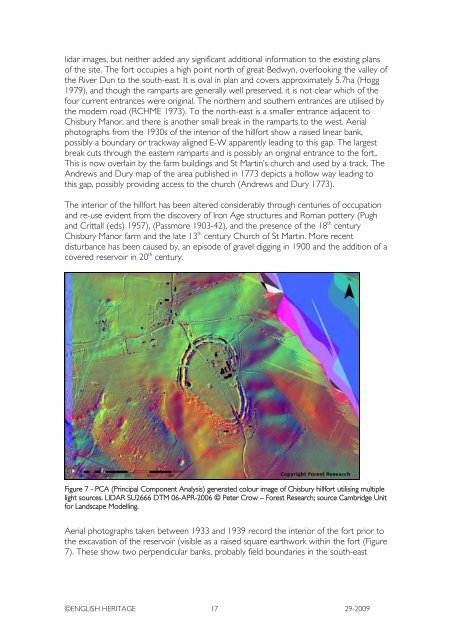
lidar images, but nei<strong>the</strong>r added any significant additional in<strong>for</strong>mation to <strong>the</strong> existing plans<br />
of <strong>the</strong> site. The <strong>for</strong>t occupies a high point north of great Bedwyn, overlooking <strong>the</strong> valley of<br />
<strong>the</strong> River Dun to <strong>the</strong> south-east. It is oval in plan and covers approximately 5.7ha (Hogg<br />
1979), and though <strong>the</strong> ramparts are generally well preserved, it is not clear which of <strong>the</strong><br />
four current entrances were original. The nor<strong>the</strong>rn and sou<strong>the</strong>rn entrances are utilised by<br />
<strong>the</strong> modern road (RCHME 1973). To <strong>the</strong> north-east is a smaller entrance adjacent to<br />
Chisbury Manor, and <strong>the</strong>re is ano<strong>the</strong>r small break in <strong>the</strong> ramparts to <strong>the</strong> west. Aerial<br />
photographs from <strong>the</strong> 1930s of <strong>the</strong> interior of <strong>the</strong> hill<strong>for</strong>t show a raised linear bank,<br />
possibly a boundary or trackway aligned E-W apparently leading to this gap. The largest<br />
break cuts through <strong>the</strong> eastern ramparts and is possibly an original entrance to <strong>the</strong> <strong>for</strong>t,.<br />
This is now overlain by <strong>the</strong> farm buildings and St Martin’s church and used by a track. The<br />
Andrews and Dury map of <strong>the</strong> area published in 1773 depicts a hollow way leading to<br />
this gap, possibly providing access to <strong>the</strong> church (Andrews and Dury 1773).<br />
The interior of <strong>the</strong> hill<strong>for</strong>t has been altered considerably through centuries of occupation<br />
and re-use evident from <strong>the</strong> discovery of Iron Age structures and Roman pottery (Pugh<br />
and Crittall (eds) 1957), (Passmore 1903-42), and <strong>the</strong> presence of <strong>the</strong> 18 th century<br />
Chisbury Manor farm and <strong>the</strong> late 13 th century Church of St Martin. More recent<br />
disturbance has been caused by, an episode of gravel digging in 1900 and <strong>the</strong> addition of a<br />
covered reservoir in 20 th century.<br />
Figure 7 - PCA (Principal Component Analysis) generated colour image of Chisbury hill<strong>for</strong>t utilising multiple<br />
light sources. LIDAR SU2666 DTM 06-APR-2006 © Peter Crow – Forest Research; source Cambridge Unit<br />
<strong>for</strong> Landscape Modelling.<br />
Aerial photographs taken between 1933 and 1939 record <strong>the</strong> interior of <strong>the</strong> <strong>for</strong>t prior to<br />
<strong>the</strong> excavation of <strong>the</strong> reservoir (visible as a raised square earthwork within <strong>the</strong> <strong>for</strong>t (Figure<br />
7). These show two perpendicular banks, probably field boundaries in <strong>the</strong> south-east<br />
©ENGLISH HERITAGE 17 29-2009


