Section 06 - UKOTCF
Section 06 - UKOTCF
Section 06 - UKOTCF

Create successful ePaper yourself
Turn your PDF publications into a flip-book with our unique Google optimized e-Paper software.
<strong>Section</strong> 6: Spatial Planning, Protected Areas and<br />
International Standards – assets or liabilities?<br />
Co-ordinators: Colin Hindmarch (<strong>UKOTCF</strong> Council) &<br />
John Cooper (CORE Initiatives, Rondebosch, South Africa)<br />
Issues relating to resource use in terrestrial and marine realms are clearly central to sustainable development.<br />
Used correctly, spatial planning, protected areas and international site designations are all tools that<br />
can contribute to the protection of livelihoods and the environment, whilst empowering stakeholders and<br />
ensuring resources and ecosystem services for the next generation. Equally, however, if such measures are<br />
poorly applied, or abused, they can become liabilities (actual or perceived) to communities, fail to deliver<br />
environmental protection, and even undermine the very concept of sustainability.<br />
This session of the Making the Right Connections conference heard presentations which drew on experiences<br />
(both good and bad) in a range of relevant areas. The increasing integration of environmental<br />
considerations into spatial and strategic planning in the UK and the European Union was examined. The<br />
consequences of an ineffectual planning process and suppression of environmental democracy in the<br />
Turks and Caicos Islands was the focus of an impassioned and eloquent presentation. An overview of the<br />
approach to marine planning and protected areas in the Isle of Man was followed by a brief presentation<br />
on a potentially globally significant marine reserve in the British Indian Ocean Territory. Following discussion<br />
of issues raised thus far, aspects of international designations (particularly under the Ramsar and<br />
World Heritage Conventions) were examined. Delegates then heard of progress and challenges in relation<br />
to protected areas and wider environmental management planning in Montserrat, the Pitcairn Islands<br />
and the British Virgin Islands. Further discussion followed. Key conclusions from the session included<br />
acknowledgement of the value of linking spatial planning, protected areas and internationally designated<br />
sites into more integrated approaches and broader strategic planning, whilst ensuring that stakeholders<br />
and wider communities have a voice in the process.<br />
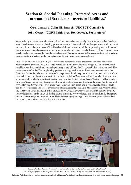
From left: Rob Thomas (rapporteur), Fiona Gell, Euwonka Selver and Colin Hindmarch<br />
(Photos of conference participants in this <strong>Section</strong> by Thomas Hadjikyriakou unless otherwise stated)<br />
Making the Right Connections: a conference on conservation in UK Overseas Territories, Crown Dependencies and other small island communities, page 181
Framework Document: Protected Areas: Developing<br />
Sustainable Policy Options<br />
Colin Hindmarch (<strong>UKOTCF</strong> Council)<br />
Hindmarch, C. 2010. Framework document: Protected Areas: Developing Sustainable<br />
Policy Options. pp 182-185 in Making the Right Connections: a conference<br />
on conservation in UK Overseas Territories, Crown Dependencies and other<br />
small island communities, Grand Cayman 30th May to 5th June 2009 (ed. by M.<br />
Pienkowski, O. Cheesman, C. Quick & A. Pienkowski). UK Overseas Territories<br />
Conservation Forum, www.ukotcf.org<br />
The widespread, historic failure to consider fully the environmental impacts of<br />
economic development activities which rely fundamentally on natural resources has<br />
severely undermined the sustainability of human endeavours. However, there is an<br />
increasing shift towards the integration of environmental considerations into highlevel<br />
policy development, as the need to protect biodiversity and ecosystem services<br />
becomes more urgent and apparent. Models for this new approach are emerging,<br />
including in the UK and the European Union.<br />
Many of the problems faced by the environment<br />
have been peripheral to the human exploitation of<br />
natural resources. As such, they have been tackled<br />
in an ad hoc, responsive, symptomatic way, without<br />
a coherent approach to the problem of such<br />
things as habitat loss.<br />
The growing realisation that the ‘natural’ environment<br />
is a key life support system that underpins<br />
innumerable economic activities (MEA 2005),<br />
suggested the need to factor the value of ecosystem<br />
services into the essence of economic planning<br />
(Hindmarch et al. 20<strong>06</strong>). The idea has been around<br />
for some time but it is becoming the new wisdom<br />
(POST 2007) and consequently, environmental<br />
concerns are now being incorporated into policy<br />
development at the highest levels.<br />
Dr Colin Hindmarch (<strong>UKOTCF</strong> Council) colinhindmarch@talktalk.net<br />
Although some UK territories have already moved<br />
along this road to varying degrees, it is worth<br />
looking first at an example from Europe, as a basis<br />
for discussion. Following the lead given by the<br />
Convention on Biological Diversity (CBD 1992),<br />
the EU Biodiversity Strategy gave momentum to<br />
the process of internalising conservation values by<br />
recommending that biodiversity concerns should<br />
be integrated into all EU policies (EUBS 1998).<br />
This was reinforced by a number of follow-up action<br />
plans (EUBAP 2001) that embraced Natural<br />
Resources, Agriculture, Fisheries and Economic<br />
Development. This process has helped to strengthen<br />
policy integration and is opening up a way for<br />
a new relationship between the environment and<br />
human activities.<br />
Part of this new relationship is an emergent type of<br />
strategic resource management that factors ecological<br />
concerns into economic thinking, thereby<br />
internalising the hidden costs of human activities<br />
(Hindmarch & Pienkowski 2000). This link will<br />
place economic limitations on over-exploitation,<br />
making it difficult, for instance, to roll out policies<br />
or implement plans that encourage farming practices<br />
(in the intensive farming systems of Europe)<br />
that erode the soil, pollute the water supply, threaten<br />
food security and degrade biodiversity.<br />
This will help protect the ecological processes that<br />
maximise the biological potential of the protected<br />
area ‘hot-spots’, and, indeed, the wider environment.<br />
These will be increasingly protected and<br />
supported by an approach to policy development<br />
that accounts for the economic value of ecosystem<br />
services (Hindmarch et al. 20<strong>06</strong>). This approach<br />
will need a ‘compatible planning’ system and an<br />
environmental movement that becomes active at<br />
all levels of the policy process and works with the<br />
business community to devise sustainable development<br />
options.<br />
Fortunately, recent reforms to the UK legislative<br />
system have produced a promising policy model<br />
Making the Right Connections: a conference on conservation in UK Overseas Territories, Crown Dependencies and other small island communities, page 182
Figure 1. 1: Integrating Integrating ecological ecological concerns into concerns development into plans: development policy process plans: and governance policy process (schematic and representation<br />
based (schematic loosely on new representation UK procedures). based SIA = Strategic loosely Impact on new Assessment; UK procedures). EIA = Environmental Impact<br />
governance<br />
Assessment. (References: UKLSP 2008, UKRSS 2004, UKSDS 2005),<br />
B) Governance: Basic Needs<br />
A) Policy Process: Basic Elements<br />
i) National Guiding Principles (UKSDS)<br />
National integrated vision on Living within limits<br />
key overarching concerns, e.g.: Sustainable economy<br />
Good governance<br />
Human well being etc.<br />
ii) Regional Strategies (UKRSS)<br />
Broad regional strategy (15-20<br />
yr timescale) on a range of<br />
interrelated themes, e.g.:<br />
Biodiversity<br />
Rural development<br />
Climate change<br />
Spatial planning (informs LDF)<br />
Robust evidence base<br />
Impact assessment (SIA, EIA)<br />
Published proposal<br />
Consultation process (inc. civil soc.)<br />
Proposal modification process<br />
Examination in public<br />
Appeals process (developers rights)<br />
Monitoring agreement<br />
Enforcement process (env. liability)<br />
Plan review process (timescale)<br />
iii) Local Development Framework (UKLSP)<br />
Shaping and delivering Community involvement<br />
sustainable, community - Monitoring reports (annual)<br />
endorsed spatially-explicit<br />
Development plan documents<br />
strategies (3yr timescale).<br />
iv) Development Control<br />
Ensuring that development<br />
complies with local, national<br />
and international policies.<br />
Development control<br />
(outlined very sketchily in Figure 1) in that it:<br />
Has a coherent policy process (Figure 1: A) with a<br />
nested suite of ‘tools’ ranging from an overarching<br />
general vision on key concerns (i), through broad<br />
regional strategies (ii), to local implementation<br />
frameworks (iii), to measures for the enforcement<br />
of policies on the ground (iv);<br />
Ensures that biodiversity and sustainability concerns<br />
are integral to each stage of the process (i<br />
-iv) and their related themes, and that it;<br />
Includes a system of governance (Figure 1: B) that<br />
ensures due process with respect to impact assessment,<br />
public involvement, monitoring, review,<br />
environmental liability and enforcement.<br />
This model is not necessarily one that will fit all<br />
situations; but it could be a useful starting point<br />
for thinking about how Territory administrations<br />
might enhance their support for the protection and<br />
sustainable management of their natural resources<br />
and at the same time meet some of the challenges<br />
posed by environmental governance.<br />
In preparation for discussions on this topic, delegates<br />
were asked to compare the workings of their<br />
own administrations with that of the developing<br />
UK model (Figure 1). Table 1 is provided as one<br />
framework by which systems in individual territories<br />
can be rapidly assessed, and compared to the<br />
evolving UK approach.<br />
References<br />
CBD (1992) No. 3<strong>06</strong>19, Multilateral Convention<br />
on Biological Diversity (with annexes),<br />
Making the Right Connections: a conference on conservation in UK Overseas Territories, Crown Dependencies and other small island communities, page 183
Table 1. Integration of ecological concerns into development plans: policy process and governance.<br />
Table 1: Integration of ecological concerns into development plans: policy process and governance. <strong>UKOTCF</strong><br />
assay of territory models.<br />
Name of Territory:<br />
Policy tools<br />
(Figure 1 A)<br />
Are there National<br />
Guiding Principles?<br />
Yes No Comments on sustainability issues – or other matters.<br />
Are there regional<br />
strategies?<br />
Are there local<br />
development<br />
frameworks?<br />
Are there development<br />
control procedures?<br />
Are the policy tools<br />
(above) part of an<br />
integrated package?<br />
Governance<br />
measures<br />
(Figure 1 B)<br />
Is there a requirement<br />
for impact assessment?<br />
Are plans and proposals<br />
published?<br />
Is there a process for<br />
public consultation?<br />
Is there a plan and<br />
proposal modification<br />
process?<br />
Are plans and proposals<br />
examined in public?<br />
Are there opportunities<br />
to appeal against<br />
decisions?<br />
Are agreed plans and<br />
development schemes<br />
monitored?<br />
Is there an enforcement<br />
process?<br />
Are plans and policies<br />
reviewed regularly?<br />
Making the Right Connections: a conference on conservation in UK Overseas Territories, Crown Dependencies and other small island communities, page 184
concluded at Rio de Janeiro on 5 June<br />
1992 www.cbd.int/doc/legal/cbd-un-en.pdf<br />
(accessed 14/04/09).<br />
EUBAP (2001) Biodiversity Action Plans<br />
for: Conservation of Natural Resources;<br />
Agriculture; Fisheries; Economic and<br />
Development Co-operation. http://<br />
biodiversity-chm.eea.europa.eu/stories/<br />
STORY1016812291 (accessed: 14/04/09).<br />
EUBS (1998) European Union Biodiversity<br />
Strategy. Com (1998) 42 final http://<br />
ec.europa.eu/environment/docum/pdf/9842en.<br />
pdf (accessed 25/03/07).<br />
Hindmarch, C., Harris, J. & Morris, J (20<strong>06</strong>)<br />
Growth and sustainability: integrating<br />
ecosystem services into economics. Biologist,<br />
Vol. 53 Number 3, June 20<strong>06</strong>, p135-142.<br />
Hindmarch, C. & Kirby, J. (2002) Corridors for<br />
birds within a Pan-European Ecological<br />
Network. Nature and Environment series No.<br />
123. ISBN 92-871-4907-6, Council of Europe<br />
Publishing.<br />
Hindmarch, C. & Pienkowski, M. (2000) Land<br />
management: the hidden costs. British<br />
Ecological Society ISBN <strong>06</strong>32056525<br />
Blackwell Science, Oxford.<br />
MEA (2005): Millennium Ecosystem Assessment.<br />
Ecosystems and Human Well-being:<br />
Synthesis. Preface. Island Press, Washington,<br />
DC. Copyright © 2005 World Resources<br />
Institute. www.maweb.org/documents/<br />
document.356.aspx.pdf (accessed 09/04/09).<br />
POST (Parliamentary Office of Science and<br />
Technology ) (2007) Ecosystem Services<br />
(2007) www.parliament.uk/documents/<br />
upload/postpn281.pdf (14/04/09).<br />
UKLSP (2008) Local Spatial Planning; Planning<br />
Policy Statement 12. www.communities.<br />
gov.uk/documents/planningandbuilding/pdf/<br />
pps12lsp.pdf (accessed 14/04/09).<br />
UKRSS (2004) Regional Spatial Strategies<br />
Planning Policy Statement 11. www.<br />
communities.gov.uk/documents/<br />
planningandbuilding/pdf/147423.pdf<br />
(accessed 14/04/09).<br />
UKSDS (2005) Securing the Future - UK<br />
Government Sustainable Development<br />
Strategy www.defra.gov.uk/sustainable/<br />
government/publications/uk-strategy/index.<br />
htm (accessed 14/04/09).<br />
Making the Right Connections: a conference on conservation in UK Overseas Territories, Crown Dependencies and other small island communities, page 185
Protected areas: a new economic context and a sustainable<br />
future<br />
Colin Hindmarch (<strong>UKOTCF</strong> Council)<br />
Hindmarch, C. 2010. Protected areas: a new economic context and a sustainable future.<br />
pp 186-194 in Making the Right Connections: a conference on conservation in<br />
UK Overseas Territories, Crown Dependencies and other small island communities,<br />
Grand Cayman 30th May to 5th June 2009 (ed. by M. Pienkowski, O. Cheesman,<br />
C. Quick & A. Pienkowski). UK Overseas Territories Conservation Forum, www.<br />
ukotcf.org<br />
In many countries, protected areas have been an effective way of preventing the<br />
destruction of some of our biodiversity hot-spots; however, these remain vulnerable<br />
because their fate is intertwined with that of a wider environment that continues to<br />
deteriorate due to unsustainable human activity. These changes not only threaten<br />
protected areas but also the natural ‘capital’ that is fundamentally important to human<br />
economic activity and even humanity itself. The only realistic way of challenging<br />
this situation is to integrate ecological concerns into the heart of human economic<br />
activities and support these with effective enforcement. There is a convincing<br />
rationale for this route to a sustainable future, and a practical way forward using<br />
emerging European and National (UK) policies.<br />
Dr Colin Hindmarch, <strong>UKOTCF</strong> Council, colinhindmarch@talktalk.net<br />
A short history of sustainable resource management<br />
and environmental protection<br />
Balancing human economic activity and the environment’s<br />
ability to recover from exploitation has<br />
become a critical issue, not least for island habitats,<br />
which suffer disproportionately from the global<br />
change.<br />
Unsustainable human activity has produced widespread<br />
environmental problems. Where these have<br />
been responded to locally, the corrective measures<br />
have often faltered and produced new problems.<br />
Whilst these measures highlighted unwanted<br />
change and provided a focus for conservation action,<br />
they were incapable of tackling the underlying<br />
causal processes, which intensified to the point<br />
where they threatened the means of production<br />
(Hindmarch & Pienkowski 2000) and the basis of<br />
human society (MEA 2005). These life threatening<br />
impacts compelled policymakers to address the<br />
issues behind environmental degradation and, at<br />
the same time, provided some insight into the processes<br />
that trigger ecological change. They also cast<br />
some light on the difficulties faced by protected<br />
areas.<br />
In accepting the gravity of the global environmental<br />
crisis and then “making the right connections”,<br />
policymakers are now beginning to develop and<br />
deliver policies that have the potential not only to<br />
secure the future of human economic development,<br />
but also safeguard the environment and support the<br />
work of protected areas.<br />
Connecting human activity and ecological<br />
processes.<br />
The relationship between human activities and<br />
ecological processes is predicted by the commonsense<br />
notion that, as the level of human exploitation<br />
increases, ecological and economic factors<br />
become linked, such that a change in one affects<br />
the status of the other (O’Neill et al. 1998).<br />
Making the Right Connections: a conference on conservation in UK Overseas Territories, Crown Dependencies and other small island communities, page 186
Figure 1 illustrates this process of ‘linkage’ in<br />
terms of the time taken for a ‘natural’ system to<br />
recover from increasing levels of human activity<br />
(perturbation). At low levels of activity recovery<br />
time is negligible (a), but as exploitation increases,<br />
‘natural’ and ‘economic’ processes become linked<br />
such that they affect one another. At low levels of<br />
exploitation, this linkage (b) is able to increase biodiversity<br />
(crops, livestock and production systems)<br />
(see also Figure 3 c,d,e,f) and ecosystem resilience;<br />
but as the level of exploitation increases, a point is<br />
reached when the exploited system becomes incapable<br />
of recovery (c) precipitating a shift in state<br />
and possible collapse.<br />
It is difficult to assess whether the current state of<br />
‘linkage’ is approaching a critical shift in state;<br />
but there are reasons to believe that human economic<br />
activity is degrading the environment to the<br />
point where the resilience of its ‘natural capital’<br />
(see Definitions) is being seriously reduced, along<br />
with its capacity to provide the ‘ecosystem services’<br />
(see Definitions) needed to sustain economic<br />
development, human well-being and even human<br />
life itself.<br />
Some definitions<br />
Natural capital: An extension of the economic notion<br />
of capital (manufactured means of production)<br />
to environmental ‘goods and services’. It refers<br />
to a stock (e.g. a forest) which produces a flow<br />
of goods (e.g. new<br />
trees) and services<br />
(e.g. carbon sequestration,<br />
erosion control,<br />
habitat). (EEA<br />
2009)<br />
Ecosystem services:<br />
“Ecosystem services<br />
are the benefits<br />
people obtain from<br />
ecosystems. These<br />
include provisioning<br />
services such as<br />
food, water, timber,<br />
and fibre; regulating<br />
services that affect<br />
climate, floods, disease,<br />
wastes, and water<br />
quality; cultural<br />
services that provide<br />
recreational, aesthetic,<br />
and spiritual<br />
benefits; and supporting<br />
services such as soil formation, photosynthesis,<br />
and nutrient cycling.… The human species, while<br />
buffered against environmental changes by culture<br />
and technology, is fundamentally dependent on the<br />
flow of ecosystem services.” (MEA 2005)<br />
Figure 1. Interaction between ‘natural’ and economic systems using data from O’Neill et al<br />
(1998).<br />
Free goods: “We have habitually counted natural<br />
capital as a free good. This might have been justified<br />
in yesterday’s empty world, but in today’s full<br />
world it is anti-economic. The error of implicitly<br />
counting natural capital consumption as income is<br />
customary in three areas: (1) the System of National<br />
Accounts; (2) evaluation of projects that deplete<br />
natural capital; and (3) international balance of<br />
payments accounting.” (Daly 1999).<br />
Short-term benefits – long-term consequences:<br />
“Historically, most responses to addressing ecosystem<br />
services have concentrated on the short-term<br />
benefits from increasing the productivity of provisioning<br />
services. Far less emphasis has been placed<br />
on the long-term consequences of ecosystem<br />
change and consequent effects for the provision of<br />
services. As a result the current management regime<br />
falls short of the potential for meeting human<br />
needs and conserving ecosystems.” (MEA 2005,<br />
p, 100)<br />
Connecting theory with reality<br />
These adverse impacts are linked with forms of<br />
Making the Right Connections: a conference on conservation in UK Overseas Territories, Crown Dependencies and other small island communities, page 187
economic activity that push production beyond<br />
sustainable limits on a large scale. An example<br />
of this phenomenon is provided by the European<br />
Union’s Common Agricultural Policy (CAP),<br />
probably the best supported ecological experiment<br />
since Genesis (Hindmarch et al. 20<strong>06</strong>). This aimed<br />
to provide cheap food and reduce imports, partly<br />
inspired by the hardships suffered by the drafters<br />
as young people during the Second World War.<br />
However, within a few decades, its hidden costs<br />
were revealed as the removal and simplification<br />
of semi-natural habitats, loss of locally distinctive<br />
crops and livestock, and the abandonment of farming<br />
systems that had a proven record of sustainable<br />
production and an ability to increase biodiversity<br />
(Hindmarch & Pienkowski 2000).<br />
Ecosystem breakdown: policy reaction<br />
The effect of this unsustainable economic activity<br />
was, for a long time, perceived as a random succession<br />
of ‘service’ disruptions that were addressed<br />
by a growing number of largely responsive, ‘downstream’<br />
environmental legislative fixes (Figure<br />
2). These struggled to deal effectively with the<br />
problem, because they were opposed by heavy ‘upstream’<br />
measures (production support) that perpetuated<br />
the problem (Hindmarch & Pienkowski<br />
2000).<br />
The protected area approach to conservation, for<br />
example, was developed to secure the long-term<br />
survival of important habitats. However, many<br />
‘protected’<br />
areas continue<br />
to suffer<br />
from damaging<br />
external<br />
influences and<br />
inappropriate<br />
management<br />
(Lee & Barrett<br />
2001; Allison<br />
et al. 1998),<br />
along with the<br />
associated loss<br />
of biodiversity<br />
(Eionet 2008)<br />
and ecological<br />
isolation<br />
(DeFries et al.<br />
2005). Efforts<br />
to deal with<br />
these issues<br />
increasingly involve such things as buffer zones<br />
(Shafer 1999), corridors (Jongman & Kamphorst<br />
2002) and networks (Natura 2000; EC 2000).<br />
However, since these are simply area-based approaches<br />
writ large (Hindmarch & Pienkowski<br />
2000), they are unlikely to provide a defence<br />
against background environmental change on their<br />
own.<br />
Figure 2. Number of items of EU environmental legislation adopted between 1996 and 2007 (data<br />
appoximated from Figure 2.1.1 of IEEP 2009)<br />
Notes: The bars show each year from 1966 to 2007. The decline in output from 2001 (yellow box)<br />
may reflect a change from responsive to integrative modes of policy development (see Figure 4).<br />
The ongoing limitations of site-based conservation<br />
and the pressing need to secure the economic<br />
potential and life-support functions of the wider<br />
environment are encouraging more of a ‘systemic’<br />
approach to environmental protection (EUBS<br />
1998) that involves ‘embedding ecosystem approaches’<br />
(Defra 2007) into conservation management<br />
(Smith & Maltby 2003) and spatial planning<br />
(Nowicki et al. 2005). Importantly, the need for<br />
this reform is being supported by an understanding<br />
of the need to re-establish a sustainable linkage<br />
between economic development and ecological<br />
processes, by integrating ecological concerns into<br />
the heart of economic planning (Hindmarch et al.<br />
20<strong>06</strong>).<br />
Discerning causes<br />
The unintended consequences of the CAP support<br />
for increased production and the subsequent<br />
difficulties in dealing with the ensuing problems<br />
using bottom-up remedies, gave some insight into<br />
the relationship between policy drivers and ecological<br />
impacts. It showed that high-level policies<br />
Making the Right Connections: a conference on conservation in UK Overseas Territories, Crown Dependencies and other small island communities, page 188
Figure 3. Simple policy<br />
measures can shift a system<br />
from one state to another.<br />
Comparison of European<br />
low- and high-input land<br />
management systems in<br />
terms of characteristics,<br />
environmental effects and<br />
conjectured causal processes.<br />
are able to manipulate environmental processes on<br />
a massive scale over a very short timescale and, by<br />
way of very simple measures, flip a system from a<br />
mode that maintains, or even augments, renewable<br />
resources (traditional land management systems) to<br />
one that undermines long-term productivity (intensive<br />
land management systems).<br />
Figure 3 arranges the discriminating features of<br />
both traditional and intensive land-management<br />
systems into contrasting causal patterns and, at<br />
each stage, notes a few of<br />
the more important outcomes.<br />
This shows that<br />
human exploitation, in the<br />
form of traditional lowinput<br />
production (column<br />
1), has a number of clear<br />
features:<br />
• it uses minimal external<br />
inputs (a) and a rate and<br />
scale of exploitation that is<br />
constrained by local circumstances<br />
(b).<br />
• it also has an inherent<br />
need for a wide range of<br />
locally adapted plants,<br />
animals, landscapes, technologies,<br />
economies and<br />
cultures (types) (d), and;<br />
• involves the ongoing<br />
selection of ‘types’ that can<br />
most effectively exploit<br />
locally-distinctive circumstances<br />
(e).<br />
Traditional forms of exploitation,<br />
therefore, constitute<br />
a divergent process that not<br />
only depends upon inherited<br />
diversity (d) but also<br />
maintains and augments<br />
it (c, e), and increases the<br />
provision of natural capital<br />
and ecosystem services (f).<br />
This suggests that they are not just sustainable, in<br />
the sense that they are activities that can be maintained<br />
indefinitely, but are evolutionarily active<br />
(see points 5-9 in Figure 1b) and able to enhance<br />
the productive base of the environment.<br />
The factor that triggers the movement from sustainable<br />
‘linkage’ (column 1) to collapse (column<br />
2) appears to be the use of heavy external inputs on<br />
a large scale (g). This overrides naturally occurring<br />
Making the Right Connections: a conference on conservation in UK Overseas Territories, Crown Dependencies and other small island communities, page 189
limits on production (h) and simplifies the environment<br />
by favouring a narrow range of productive<br />
types (i). This increases production (h), but causes<br />
widespread pollution, soil erosion and loss of<br />
biodiversity. It also displaces inherited diversity (j)<br />
in the form of locally adapted types and involves<br />
the convergent selection (k) of a narrow range of<br />
productive types dependent on the external inputs<br />
provided. This further simplifies the environment<br />
and compromises the provision of natural capital<br />
and ecosystem services (l).<br />
The processes illustrated by Figure 3 support the<br />
‘linkage’ model (O’Neill et al. 1998). They also<br />
provide policymakers with a conceptual tool for<br />
identifying ways of building restraints into economic<br />
policies by decreasing external inputs (g),<br />
protecting biodiversity (c, d, e) and integrating the<br />
value of natural capital and ecosystem services into<br />
economic processes (sensu Hindmarch et al. 20<strong>06</strong>),<br />
rather than counting them as ‘free goods’ (see<br />
Definitions).<br />
Emergence of sustainable development initiatives<br />
at a European level<br />
The adverse environmental impacts of the CAP<br />
experience provided a compelling argument for a<br />
rapid realignment of farming subsidies. However,<br />
there were also concerns that farm subsidies were<br />
becoming too expensive and would increase with<br />
the planned accession of the Central European<br />
States (Schröder 2002). It was also becoming apparent<br />
that these subsidies were beginning to complicate<br />
world trade negotiations (Europa 2004).<br />
These influences combined to favour an approach<br />
to policy development that increasingly addresses<br />
causes rather than symptoms (Figure 4). This has<br />
helped to put the concerns of biodiversity and sustainable<br />
development at the heart of European affairs<br />
through a succession of initiatives, including<br />
the European Union Biodiversity Strategy (EUBS<br />
1998), its related Action Plans (EUBAP 2001) and<br />
the ongoing Malahide process (EC 20<strong>06</strong>). Importantly,<br />
it has also informed the development and<br />
review of the European Sustainable Development<br />
Strategy (EUSDS 20<strong>06</strong>), which now includes provisions<br />
that will:<br />
• Eliminate policies that are ‘incompatible with<br />
sustainable development’ (EUSDS 20<strong>06</strong>, para.<br />
24);<br />
• Improve the ‘management and avoid overexploitation<br />
of natural<br />
resource’<br />
(EUSDS 20<strong>06</strong>,<br />
para. 13);<br />
• Encourage<br />
‘recognizing<br />
the value<br />
of ecosystem<br />
services’<br />
(EUSDS,<br />
20<strong>06</strong>, para.<br />
13).<br />
Figure 4. Development of European environmental policy: schematic representation. Adapted<br />
from Hindmarch et al. (20<strong>06</strong>).<br />
These paradigm-shifting<br />
provisions are<br />
part of a highlevel<br />
fiscal<br />
and regulatory<br />
framework<br />
for sustainable<br />
economic<br />
growth. Over<br />
time, this<br />
could help to<br />
protect the environment<br />
and<br />
its biodiversity<br />
Making the Right Connections: a conference on conservation in UK Overseas Territories, Crown Dependencies and other small island communities, page 190
hot-spots (including those with protected area status).<br />
This would be by fostering an approach to resource<br />
management that incorporates conservation<br />
into all decision-making processes, and factors the<br />
value of natural capital and the ecosystem services<br />
it provides into economic planning (Hindmarch et<br />
al. 20<strong>06</strong>; Steiner 20<strong>06</strong>). These overarching measures<br />
have profound implications for European<br />
member states and associated Overseas Countries<br />
and Territories (OCTs).<br />
National responses to the European policy<br />
reform<br />
The process of reform underpinning the European<br />
Sustainable Development Strategy (EUSDS 20<strong>06</strong>)<br />
has resulted in a cascade of compliant reforms<br />
throughout European institutions and is informing<br />
the development of a more coherent approach<br />
to Europe’s OCTs (OAD 2007; Hindmarch 2007;<br />
IUCN 2008). In the case of the UK, these reforms<br />
have already produced a promising joined-up<br />
policy model (outlined in Figure 5). Importantly,<br />
this provides:<br />
• A coherent policy process with a nested suite<br />
of ‘tools’ ranging from an overarching general<br />
vision on key concerns (i) through broad<br />
Figure 5. Integrating ecological concerns into development plans: policy process and governance<br />
(schematic representation based loosely on the UK approach)<br />
Making the Right Connections: a conference on conservation in UK Overseas Territories, Crown Dependencies and other small island communities, page 191
egional strategies (ii) to local implementation<br />
frameworks (iii) to measures for the enforcement<br />
of policies on the ground (iv);<br />
• Instruments that ensure the integration of biodiversity<br />
and sustainability concerns into each<br />
stage of the process (i -iv) and their related<br />
themes;<br />
• A system of governance that ensures due process<br />
with respect to impact assessment, public<br />
involvement, monitoring, review, environmental<br />
liability and enforcement (v).<br />
Although this model has been developed to suit the<br />
particular conditions of the UK, its flexible, ‘delegated’<br />
structure would provide a useful strategic<br />
context for UKOT administrations as part of their<br />
reform of environmental governance (<strong>UKOTCF</strong><br />
2007; FAC 2008). Importantly, it would establish<br />
local ownership of a fiscal and regulatory network<br />
that extended to the core of Europe, helping to access<br />
resources and influence the up-stream policy<br />
initiatives that may affect the Territories.<br />
Taking things forward<br />
It is possible that the various elements of the model<br />
will progress at different rates and that environmental<br />
concerns might lag behind. There is likely<br />
also to be some denial over such things as:<br />
• Whether there are in fact ‘limits to growth’ -<br />
even though this has been a widely accepted<br />
as a logical position for some time (sensu<br />
Malthus 1798);<br />
• To what extent humanity’s drive for population<br />
increase and economic growth is responsible<br />
for driving environmental change;<br />
• Whether integrating the value of hitherto ‘free’<br />
ecosystem services into economic development<br />
might be the best mechanism to moderate<br />
unsustainable activities and encourage effective<br />
husbandry of the earth’s resources.<br />
There may be resistance amongst conservationists<br />
to the idea of going beyond the safe and understandable<br />
site-based approach to habitat protection,<br />
because of its implications for established routines<br />
(Carpenter & Folke 20<strong>06</strong>) and historic investment.<br />
Overcoming these difficulties will take time, as<br />
well as the support of a social constituency (Jacobs<br />
1997) and an informed conservation movement<br />
that ‘runs’ with the ecosystem approach to habitat<br />
management and becomes involved in its development.<br />
It will also need the support of political institutions<br />
and the business community; in particular,<br />
those sections that struggle to understand the longterm<br />
economic value of the world’s natural capital<br />
and the services it provides to economic enterprises<br />
(see Definitions).<br />
References<br />
Allison, G. W., Lubchenco, J., Carr, M. H. 1998.<br />
Marine Reserves Are Necessary But Not<br />
Sufficient For Marine Conservation. ESA:<br />
Ecological Applications: Vol. 8, Suppl. 1:<br />
Ecosystem Management for Sustainable<br />
Marine Fisheries, pp. S79-S92. http://www.<br />
esajournals.org/doi/abs/10.1890/1051-<br />
0761(1998)8%5BS79:MRANBN%5D2.0.CO%3B2<br />
(accessed 17/04/09).<br />
Carpenter S. R. & Folke C. 20<strong>06</strong>. Ecology for<br />
transformation. Trends in Ecology and Evolution,<br />
621: in press, accessed electronically, Elsevier,<br />
www.sciencedirect.com .<br />
Daly, H. E. 1999. Five policy recommendations<br />
for a sustainable economy. Text of the speech<br />
on receiving the ‘Sophie Prize’ in Oslo on 15<br />
June 1999. Available at: http://www.feasta.org/<br />
documents/feastareview/daly2.htm (accessed<br />
17/04/09).<br />
Defra 2007. Securing a healthy natural environment: an<br />
action plan for embedding an ecosystem approach<br />
http://www.defra.gov.uk/wildlife-countryside/pdf/<br />
natural-environ/eco-action-exec.pdf<br />
DeFries, R., Hansen, A., Newton, A.C. & Hansen, M.<br />
C. 2005. Increasing Isolation Of Protected Areas<br />
In Tropical Forests Over The Past Twenty Years.<br />
Ecological Applications: Vol. 15, No. 1, pp. 19-26.<br />
doi: 10.1890/03-5258. http://www.esajournals.org/<br />
doi/abs/10.1890/03-5258 (accessed 17/04/09).<br />
EC 2000. Managing Natura 2000 sites : The provisions<br />
of Article 6 of the ‘Habitats’ Directive 92/43/EEC.<br />
Luxembourg: Office for Official Publications of<br />
the European Comm unities 2000, 69 pp. ISBN<br />
92-828-9048-1 http://ec.europa.eu/environment/<br />
nature/natura2000/management/docs/art6/<br />
provision_of_art6_en.pdf (accessed 25/04/09).<br />
EC 20<strong>06</strong>. Halting the loss of biodiversity by 2010 and<br />
beyond: sustaining ecosystem services for human<br />
well being. Communication from the Commission<br />
of the European Communities. COM(20<strong>06</strong>)<br />
216 final. http://eurosai.nik.gov.pl/en/site/<br />
px_COM_20<strong>06</strong>_216_Biodiversity.pdf (accessed<br />
09/04/09).<br />
EEA 2009. Environmental Terminology and Discovery<br />
Service (ETDS): European Environment Agency,<br />
Kongens Nytorv 6, DK-1050 Copenhagen K,<br />
Denmark. Available at: http://glossary.eea.eu.int/<br />
EEAGlossary/N/natural_capital (accessed<br />
09/04/09.Eionet (2008): European Environment<br />
Information and Observation Network Networking<br />
improving Europe's environment "losing<br />
biodiversity in protected areas" 2632, 07/10/08.<br />
European Environment Agency, Kongens Nytorv<br />
Making the Right Connections: a conference on conservation in UK Overseas Territories, Crown Dependencies and other small island communities, page 192
6, DK - 1050 Copenhagen K, Denmark - Phone:<br />
+45 3336 7100 http://www.eea.europa.eu/<br />
highlights/europe-is-losing-biodiversity-2013-<br />
even-in-protected-areas (accessed 17/04/09).<br />
ELSP 2008. Local Spatial Planning; Planning Policy<br />
Statement 12. http://www.communities.gov.uk/<br />
documents/planningandbuilding/pdf/pps12lsp.pdf<br />
(accessed 14/04/09).<br />
ERSS 2004. Regional Spatial Strategies Planning Policy<br />
Statement 11. http://www.communities.gov.uk/<br />
documents/planningandbuilding/pdf/147423.pdf<br />
(accessed 14/04/09).<br />
EUBAP 2001. Biodiversity Action plans for:<br />
Conservation of Natural Resources; Agriculture;<br />
Fisheries; Economic and Development cooperation.<br />
http://biodiversity-chm.eea.europa.eu/<br />
stories/STORY1016812291 (accessed 09/04/09).<br />
EUBS 1998. European Union Biodiversity Strategy.<br />
Com (1998) 42 final http://ec.europa.eu/<br />
environment/docum/pdf/9842en.pdf (accessed<br />
25/03/07).<br />
Europa 2004. Agriculture and Rural Development: The<br />
common agricultural policy – A policy evolving<br />
with the times http://ec.europa.eu/agriculture/publi/<br />
capleaflet/cap_en.pdf (accessed 09/04/09).<br />
EUSDS 20<strong>06</strong>. Review of the EU Sustainable<br />
Development Strategy Council Of The European<br />
Union, Brussels, 9 June 20<strong>06</strong> 10117/<strong>06</strong>. http://<br />
register.consilium.europa.eu/pdf/en/<strong>06</strong>/st10/<br />
st10117.en<strong>06</strong>.pdf (accessed 09/04/09).<br />
FAC 2008. House of Commons Foreign Affairs<br />
Committee Overseas Territories Seventh<br />
Report of Session 2007–08 Report, and formal<br />
minutes Ordered by The House of Commons<br />
HC 147-I. The Stationery Office. http://www.<br />
publications.parliament.uk/pa/cm200708/cmselect/<br />
cmfaff/147/147i.pdf (accessed 28/05/09).<br />
Hindmarch, C. & Pienkowski, M. 2000. Land<br />
management: The hidden costs. British Ecological<br />
Society ISBN <strong>06</strong>32056525 Blackwell Science,<br />
Oxford.<br />
Hindmarch, C. 2007. Biodiversity on the far-flung<br />
outposts of Europe. Biologist, Vol. 54 Number<br />
2, May 2007 http://www.iob.org/userfiles/File/<br />
biologist_archive/Biol_54_2_Hindmarch.pdf<br />
(accessed 25/05/09).<br />
Hindmarch, C., Harris, J. & Morris, J. 20<strong>06</strong>. Growth<br />
and sustainability: integrating ecosystem services<br />
into economics. Biologist, Vol. 53 Number 3,<br />
June20<strong>06</strong>, p135-142 http://www.iob.org/userfiles/<br />
File/biologist_archive/Biol_53_3_Hindmarch.pdf<br />
(accessed 25/05/09).<br />
IEEP 2009. Manual of Environmental Policy: The<br />
EU and Britain. The development of EU<br />
environmental policy, figure 2.1.1. Maney<br />
Publishing Suite 1C Joseph's Well, Hanover Walk,<br />
Leeds, LS3 1AB, UK<br />
IUCN 2008. Message from Reunion: The European<br />
Union and its overseas entities: strategies<br />
to counter climate change and biodiversity<br />
loss. Official event of the French Presidencu<br />
of the European Union. http://cmsdata.iucn.<br />
org/downloads/080711_reunion_msg_en.pdf<br />
(Accessed 29/05/09).<br />
Jacobs, M. 1997. Making Sense of Environmental<br />
Capacity. CPRE; June 1997, ISBN 0 946044 66 X.<br />
Jongman R. & Kamphorst, D. 2002. Ecological<br />
corridors in land use planning and development<br />
policies. Nature and Environment, No. 125.<br />
Council of Europe Publishing, ISBN 92-871-4936-<br />
4.<br />
Lee, D.R. & Barrett, C.B. (eds) 2001. Tradeoffs or<br />
synergies?: agricultural intensification, economic<br />
development, and the environment. Chapter 21,<br />
McNeely Agriculture, Biodiversity and agricultural<br />
development: The crucial institutional issues, p4<strong>06</strong><br />
(biodiversity and protected areas).Published by<br />
CABI, 2001 ISBN 0851994350, 9780851994352.<br />
Malthus, T. R. 1798. An Essay on the Principle of<br />
Population. London: John Murray http://www.<br />
econlib.org/library/Malthus/malPlong.html<br />
MEA 2005. Millennium Ecosystem Assessment.<br />
Ecosystems and Human Well-being: Synthesis.<br />
Preface. Island Press, Washington, DC. Copyright<br />
© 2005 World Resources Institute. http://www.<br />
maweb.org/documents/document.356.aspx.pdf<br />
(accessed 09/04/09).<br />
Natura 2000. Networking programme http://www.<br />
natura.org/about.html<br />
Nowicki, P., Young, J. & Watt, A.D. (eds) 2005. The<br />
Ecosystem Approach applied to Spatial Planning,<br />
a report of the BIOFORM project. For more<br />
information please visit the BIOFORUM website:<br />
www.nbu.ac.uk/bioforum<br />
O’Neill, R.V., Kahn, J.R. & Russell, C.S. 1998.<br />
Economics and Ecology: The need for détente<br />
in conservation ecology. URL: < http://www.<br />
consecol.org/Journal/vol2/iss1/art4/>.<br />
OAD 2007. Council Decision of 19 March 2007<br />
amending Decision 2001/822/EC on the<br />
association of the overseas countries and territories<br />
with the European Community (2007/249/EC).<br />
http://eur-lex.europa.eu/LexUriServ/site/en/<br />
oj/2007/l_109/l_10920070426en00330041.pdf<br />
(accessed 28/05/09).<br />
Schröder, U. (ed.) 2002. Runaway costs or willingness<br />
to reform – the two sides to enlargement. EU<br />
Enlargement Monitor Central and Eastern<br />
Europe. No. 8 (July 17, 2002). Deutsche Bank<br />
Research. Frankfurt am Main, Germany, E-mail:<br />
marketing.dbr@db.com. http://www.dbresearch.<br />
com/PROD/DBR_INTERNET_EN-PROD/<br />
PROD0000000000043632.pdf (accessed<br />
09/04/09).<br />
Shafer, C. L. 1999. US National Park Buffer Zones:<br />
Historical, Scientific, Social, and Legal Aspects.<br />
Environmental Management , vol 23, Number<br />
1, January, 1999. pages 49-73, DOI 10.1007/<br />
s002679900167.<br />
Smith, R.D. & Maltby, E. 2003. Using the Ecosystem<br />
Approach to Implement the Conservation on<br />
Biological Diversity: Key Issues and Case<br />
Making the Right Connections: a conference on conservation in UK Overseas Territories, Crown Dependencies and other small island communities, page 193
Studies. IUCN, Gland, Switzerland and<br />
Cambridge, UK; ISBN 2-8317-0742-0 http://<br />
books.google.co.uk/books?hl=en&lr=&id=_2xM<br />
bEO3zA0C&oi=fnd&pg=PP11&dq=protectedareas+ecosystem+approach&ots=uIB_W4yruV&<br />
sig=1JwqvX0OWKztP5ZMnX4AYiRzmrI#PPP4,<br />
M1 (accessed 17/04/09).<br />
Steiner, A. 20<strong>06</strong>. Time to Make Environment and<br />
Economics Team Players: Markets Need to Work<br />
With Earth’s Life Support Systems to Achieve<br />
Development Goals. Speech by Achim Steiner,<br />
Nairobi, June 20<strong>06</strong>. United Nations Environment<br />
Programme: environment for development. http://<br />
www.unep.org/Documents.Multilingual/Default.as<br />
p?DocumentID=480&ArticleID=5299&l=en .<br />
<strong>UKOTCF</strong> 2007. Evidence submitted by the UK<br />
Overseas Territories Conservation Forum to<br />
the Parliamentary Inquiry (Security and good<br />
governance in the Overseas Territories 14th<br />
October 2007 http://www.publications.parliament.<br />
uk:80/pa/cm200708/cmselect/cmfaff/memo/147/<br />
ucm6102.htm . (accessed 09/04/09).<br />
UKSDS 2005. Securing the Future - UK Government<br />
sustainable development strategy http://www.defra.<br />
gov.uk/sustainable/government/publications/ukstrategy/index.htm<br />
(accessed 14/04/09).<br />
Making the Right Connections: a conference on conservation in UK Overseas Territories, Crown Dependencies and other small island communities, page 194
The role of environmental democracy<br />
Euwonka Selver (Turks & Caicos Islands)<br />
Selver, E. 2010. The role of environmental democracy. pp 195-199 in Making the<br />
Right Connections: a conference on conservation in UK Overseas Territories,<br />
Crown Dependencies and other small island communities, Grand Cayman 30th May<br />
to 5th June 2009 (ed. by M. Pienkowski, O. Cheesman, C. Quick & A. Pienkowski).<br />
UK Overseas Territories Conservation Forum, www.ukotcf.org<br />
The general value of natural areas, both for conserving the natural heritage and the<br />
ecosystem services that these provide, has been widely acknowledged. The vital<br />
tourism trade depends on our natural and historical environment. Effective safeguarding<br />
of such areas is dependent on a planned land-use strategy, and open and<br />
wide-ranging consultation on proposed developments in their vicinity. Planning<br />
needs to be open to local public debate, and to comment by international experts,<br />
rather than being a closed process involving a small number of people – whether<br />
elected or appointed officials, or commercial interests.<br />
In several UKOTs, the public perception is that this vital open planning consultation<br />
process does not take place, and if it does, the views expressed are not taken note of.<br />
This presentation gives some examples from several UKOTs, and then focuses more<br />
specifically on my country of the Turks and Caicos Islands.<br />
On paper, the Turks and Caicos Islands has an impressive suite of protected areas.<br />
However, despite being protected legally or by declaration, it has become apparent<br />
in recent years that this protection has not prevented significant damage to many of<br />
the protected areas, and a reduction in their effective size to enable significant, major<br />
and damaging development. In some cases, decisions by the Planning Board have<br />
been overturned in favour of built development.<br />
At the heart of this has been the secrecy and lack of consultation about proposed<br />
developments. The first anyone has known about some of these has been when the<br />
bulldozers move in. The damage has included: tearing down mangrove trees; demolition<br />
of large sections of coral reefs; and removing land from National Parks and<br />
Nature Reserves to accommodate developers. Building permits have been granted<br />
to allow construction without Environmental Impact Assessments. Where Environmental<br />
Impact Assessments have been carried out, they are extremely difficult to<br />
access, and have not been circulated for comment and peer review. Effective public<br />
consultation rarely happens. The Turks and Caicos has seen perhaps it greatest period<br />
of the destruction of the environment in the last 6 years. Nearly all the islands<br />
have been affected.<br />
Protest groups have already had some small successes, in making legal challenges<br />
to developments in protected areas. We must continue the campaign to preserve<br />
and re-instate our protected areas, demand open and full consultation on development<br />
proposals, and insist that high quality Environmental Impact Assessments (paid<br />
for by the developer but commissioned independently) are made widely available<br />
throughout the whole territory and beyond, as hard copies and on-line.<br />
Euwonka Selver, Turks & Caicos Islands, euwonka@hotmail.com<br />
Making the Right Connections: a conference on conservation in UK Overseas Territories, Crown Dependencies and other small island communities, page 195
I bid you all a pleasant morning. I want to talk to<br />
you today about a problem common to several UK<br />
Overseas Territories, especially in the Caribbean.<br />
I will concentrate on my own home, the Turks &<br />
Caicos Islands. The problem is being caused by<br />
over-development and inappropriate development,<br />
and the failure to follow internationally recognised<br />
planning procedures. Examples include the “Star<br />
Island” project, Life Resorts International development,<br />
and Salt Cay Dock. I want to highlight the<br />
importance of civil society in bringing such issues<br />
to wider public attention, and in challenging planning<br />
proposals and changing outcomes.<br />
The general value of natural protected areas, both<br />
for conserving the natural heritage and the ecosystem<br />
benefits that these provide, has been widely acknowledged.<br />
Effective safeguarding of such areas<br />
is dependent on a planned land-use strategy, and<br />
open and wide-ranging consultation on proposed<br />
developments. Planning needs to be open to local<br />
public debate, and to comment by international<br />
experts, rather than being a closed process involving<br />
a small number of people – whether elected or<br />
appointed officials, or commercial interests.<br />
As we have seen from the previous presentation,<br />
it is accepted that international best standards for<br />
planning and development require these processes<br />
to be open, and readily accessible to the public,<br />
with independent Environmental Impact Assessments.<br />
This open, consultative process with proper independent<br />
Environmental Impact Assessments<br />
happens within the United Kingdom. It is the law.<br />
However, in some UKOTs, the public perception<br />
is that this vital open planning consultation process<br />
does not take place, and if it does, the views<br />
expressed are not taken note of. Thus, this process<br />
is frequently circumvented in some UKOTs, even<br />
when it is also the law there.<br />
Many of you will be aware that, in the Turks &<br />
Caicos Islands over the last few years, we have<br />
excelled ourselves in disregarding proper planning<br />
procedures and open consultation.<br />
However, I will start with some reference to the situation<br />
in some other Caribbean UKOTs. I will then<br />
present some specific examples from the Turks and<br />
Caicos Islands.<br />
In this afternoon’s session, we look forward to<br />
hearing some presentations very relevant to my<br />
topic, from the British Virgin Islands and from here<br />
in Grand Cayman. Therefore, I will not attempt<br />
to steal their thunder. I, for one, will be keen to<br />
see what we can learn from their experience. I see<br />
that there are also presentations from Bermuda.<br />
However, I will mention one example from there,<br />
because it has been in the press, but I do not think<br />
it is in the programme, and I suspect that we can<br />
learn from it it. I hope that the participants from<br />
Bermuda – and elsewhere – will bear with me and,<br />
later in the discussion, correct anything I get wrong<br />
as well as drawing out other points that they think<br />
are relevant.<br />
Bermuda is a prosperous, very densely populated<br />
territory and, as such, the pressure for further<br />
development is continuous. There is good environmental<br />
and planning legislation, but, as in<br />
many cases, there are provisions for over-ruling<br />
objections and giving the go-ahead for development<br />
- which is a common problem in the Turks<br />
and Caicos Islands. Fairly recently, it was proposed<br />
to construct a beach bar facility on Warwick<br />
Long Bay. There was concern locally about such a<br />
development in a National Park Conservation Area<br />
and on Bermuda’s last pristine large public beach.<br />
There was a suggestion that the proposal had been<br />
approved by the Environment Minister, over-ruling<br />
the previous rejection of the proposal by the Development<br />
Applications Board, and an independent<br />
planning inspection. A petition and other action<br />
opposing the project was organised by the Bermuda<br />
Environmental and Sustainability Taskforce.<br />
On March 6 2009 the petition, signed by over 5000<br />
people, was delivered to the Premier, Dr Ewart<br />
Brown. As one of those involved, Stuart Hayward,<br />
said: “What is the point of laws and regulations<br />
and the expert counsel of planners, conservation<br />
specialists, custodians of parklands and even an<br />
Independent Inspector, if a Minister can ignore it<br />
all, and in the process endorse the trashing of the<br />
very environment he is pledged to protect?”<br />
I do not know what the outcome of this was, or<br />
will be. There are people here from Bermuda who<br />
perhaps will be able to tell us in the discussion.<br />
However, it is clear that public opinion and civil<br />
society are making themselves heard in Bermuda.<br />
We have had some small successes, but have a long<br />
way to go in this regard in the Turks and Caicos<br />
Islands, to which I now turn.<br />
On paper, the Turks and Caicos Islands have an<br />
impressive suite of protected areas. There are 33<br />
Making the Right Connections: a conference on conservation in UK Overseas Territories, Crown Dependencies and other small island communities, page 196
of these, covering approximately 270 square miles,<br />
consisting of National Parks, Nature Reserves,<br />
Sanctuaries and Historic Sites. In addition, some<br />
are protected under the National Trust Ordinance,<br />
by virtue of being held, on behalf of the people of<br />
the territory, by the Turks & Caicos National Trust.<br />
However, despite being legally protected, it has<br />
become apparent in recent years that this protection<br />
has not prevented significant damage to many<br />
of the protected areas, and a reduction in their size<br />
to enable significant, major and damaging development.<br />
Decisions by the Planning Board have<br />
been overturned by Ministers. It is imperative that<br />
the Governor exercises his power under Chapter<br />
81 No. 13 of the National Trust Ordinance, which<br />
states, “That the Governor may grant to the Trust<br />
such land or interest in land over which he has the<br />
power of disposition as he may deem fit, and may<br />
grant to the Trust control over submarine areas, including<br />
control over access to such areas, activities<br />
within such areas and such other form of control<br />
as he may deem fit”. (There is also an extensive<br />
breakdown of the powers of the Trust in Chapter<br />
81 No. 5. I bring this to your attention in order to<br />
emphasise that the Turks and Caicos has the right<br />
legislation on the book - it needs only to be moved<br />
by the Governor [although “the Governor” means,<br />
in many circumstances the Governor as advised<br />
by Ministers]. I suggest that Government grant all<br />
the land in our Nature Reserves and National Parks<br />
to the National Trust. This has not been done in<br />
many cases, so the land is used commercially,<br />
instead of being preserved for the people of the<br />
Turks and Caicos.<br />
This is the fix needed to prevent situations where<br />
secrecy and lack of consultation about proposed<br />
developments exist. The first anyone has known<br />
about some of developments has been when the<br />
bulldozers move in.<br />
The damage has included:<br />
1. Shrinking of our National Parks<br />
Land has been removed from National Parks and<br />
Nature Reserves (formally or in practice) to accommodate<br />
developers. I am sure you read the<br />
headlines about “Star Island”, which boasted of the<br />
construction of a Dubai-style artificial island. This<br />
involved major dredging in the Princess Alexandra<br />
National Park, leading to the destruction of coral<br />
reefs and invaluable fish nurseries. The world’s<br />
only conch farm was affected as well. However,<br />
my friends in Bermuda should be encouraged by<br />
the fact that there is power in numbers, as the people<br />
of the Turks and Caicos came together in protest<br />
and forced an injunction putting a stop to the<br />
artificial island. Pressure and protest groups have<br />
had significant successes, in legally challenging<br />
developments in protected areas. Petitions against<br />
Star Island, and outcries led by Tanya Streeter<br />
(professional free diver) against the dolphinarium,<br />
and countless others, seem to have caused the<br />
project to discontinue.<br />
2. Development in Nature Reserves<br />
Life Resorts International was sold land in a Nature<br />
Reserve, in Frenchman’s Creek, to construct a<br />
“Christian hotel”. This should not have happened.<br />
No development is permitted in Nature Reserves<br />
“on our books” - even visitation is said to be limited<br />
and by permit only. That needs to be enforced,<br />
and I am looking for full support from my fellow<br />
environmentalists should they continue any further<br />
with this particular project. We must maintain the<br />
campaign to preserve and re-instate our protected<br />
areas, demand open and full consultation on development<br />
proposals, and insist that high-quality<br />
Environmental Impact Assessments (paid for by<br />
the developer but commissioned independently)<br />
are made widely available throughout the whole<br />
territory, as hard copies and on-line.<br />
3. Knowingly Endangering the Population<br />
Unplanned and uncontrolled development has<br />
been allowed to encroach into flood-prone localities,<br />
placing some segments of the community in<br />
unsafe areas. Inadequate (or non-existent) drainage<br />
systems have also contributed to serious flooding<br />
problems. The third point (which the Government<br />
was aware of) relates to ad-hoc tourism-related<br />
developments. These have led to a policy shift that<br />
promotes a high concentration of hotels and condominiums<br />
within the coastal zone, in some cases set<br />
back less than 100 ft from the edge of vegetation,<br />
bringing concerns about the impact of storm-surge<br />
during storms and hurricanes. All this, knowing<br />
that the smallest increase in sea-level or other climate<br />
change effects could result in a catastrophic<br />
disaster in the islands.<br />
4. Secrecy<br />
Building permits have been granted to allow<br />
construction, without Environmental Impact Assessments<br />
or allowing any public consultation or<br />
comment from international experts. Where Envi-<br />
Making the Right Connections: a conference on conservation in UK Overseas Territories, Crown Dependencies and other small island communities, page 197
onmental Impact Assessments have been carried<br />
out, they are extremely difficult to access, and have<br />
not been circulated for comment and peer review.<br />
Public consultation does not happen, as all EIAs<br />
are copyright and property of the developers. Even<br />
since the advent of the Commission of Inquiry, I<br />
have not been able to see specific EIAs that I have<br />
requested, as the Planning Department has recently<br />
denied that the projects (the Salt Cay Marina<br />
development, the Christian Hotel and the dolphinarium<br />
project) even existed.<br />
5. Boards Bullied<br />
I could not conclude without mentioning the recent<br />
crisis in Salt Cay, where planning officials complained<br />
publicly of being “bullied” by Ministers<br />
over the Board’s refusal to allow a developer to<br />
“cut the 1.5 mile island in half”. Hon. Misick,<br />
the former Premier, was quoted as saying that the<br />
“Board’s decision was unacceptable.” The Chairman<br />
of the Board tendered his resignation dubbing<br />
it, “a matter of conscience”. The developer<br />
intended to dredge through a Historic Site, The<br />
White House (which is hundreds of years old),<br />
through the Salinas, and right through to the other<br />
side of the tiny island to an industrial dock and golf<br />
course in the historic heart of Salt Cay. This would<br />
have completely isolated the developer’s half of<br />
the island.<br />
6. Destruction of Coral Reefs and Mangroves<br />
Large sections of coral reef have been lost, as was<br />
the situation with the Carnival Cruise deal, where a<br />
significant section of the coral reef was torn down<br />
to accommodate the ships’ passage into Grand<br />
Turk. Additionally, the large influx of persons<br />
has lead to damage to shoreline sections of coral,<br />
which has encouraged the development of artificial<br />
reef systems, stimulated electronically. There was<br />
also an incident in Providenciales (in North West<br />
Point), involving a treasure hunter with a permit<br />
from the Premier, giving him permission to unearth<br />
long-lost treasure at any cost. Whether or not<br />
his quest was successful is a secret affair but, at<br />
present, heavily damaged reefs are the only evidence<br />
left of his time spent with us.<br />
Mature mangrove trees have been bull-dozed<br />
to accommodate the development of marinas in<br />
North Caicos and Providenciales. This destruction<br />
of our coral reefs and mangroves also makes us<br />
more vulnerable when Category 5 storms (such as<br />
Hurricane Ike) hit, as the ecosystems act as natural<br />
barriers against huge waves and a defence against<br />
erosion.<br />
7. We Don’t Recycle<br />
There is no proper waste disposal system. In TCI,<br />
we do not recycle anything; garbage is currently<br />
burnt in the open, which is affecting the health of<br />
many residents in Casher Garden in Grand Turk,<br />
where clusters of cancer exist, and in Blue Hills<br />
in Providenciales, where residents complained of<br />
smoke inhalation leaving the taste of burnt plastic<br />
in their mouths. There have also been reports of<br />
increased respiratory problems, blistering and other<br />
skin blemishes, since the public dump was moved<br />
to that area. The Consultancy Terms of Reference<br />
for the National Physical Sustainable Development<br />
Plan (Revised April 2008), in Paragraph 5.2 under<br />
the heading Environmental Challenges, has pointed<br />
to population growth in the context of serious planning<br />
and development challenges. The Government<br />
was fully aware of the situation of the good people<br />
of Chaser Garden in Grand Turk and Blue Hills<br />
in Providenciales, as the document goes on in the<br />
next paragraph to note “ increased population has<br />
resulted in increased volumes of liquid and solid<br />
waste, so much so, that the existing waste disposal<br />
systems do not have the capacity to adequately<br />
process the waste. The result is a serious impact<br />
on the physical environment, particularly ground<br />
water resources”.<br />
8. Straining Resources<br />
Personally, I would like to see some investigation<br />
into the Darden project, which is directly affiliated<br />
with the Red Lobster company, that entered into<br />
an agreement with the TCI Government to undertake<br />
lobster farming. There have been reports that<br />
a few thousand specimens have been taken from<br />
nurseries by the scientists for studies. However,<br />
if you live in the Turks and Caicos, you would appreciate<br />
the fact that, over the years, our resources<br />
have been dwindling from export and local consumption.<br />
So I can only imagine what next season<br />
will be like, if thousands more are being removed.<br />
In short, over the last few years, it has become<br />
apparent that the only importance of our precious<br />
natural resources to the powers-that-be is cashing<br />
it in for its monetary value. The fine words of the<br />
then Minister of Natural Resources, Fisheries and<br />
the Environment, in declaring 2007 the “Year of<br />
the Environment” (theme “Give Mother Nature a<br />
Making the Right Connections: a conference on conservation in UK Overseas Territories, Crown Dependencies and other small island communities, page 198
Helping Hand”), and endorsing 2008 as the “Year<br />
of the Coral Reef”, have not been backed up by<br />
conservation actions. Rather than giving Mother<br />
Nature a Helping Hand, she was given the back of<br />
the hand instead.<br />
The Turks and Caicos saw perhaps its greatest<br />
period of the destruction of the environment under<br />
the leadership at that time. Nearly all the islands<br />
were affected.<br />
We are a very bright and very talented people in<br />
the Caribbean. We face many common problems<br />
and I truly believe that, if we combine our resources<br />
and intelligence, we can overcome our many<br />
environmental challenges collectively. I have often<br />
said that we operate as if we are not connected in<br />
the territories, when in fact we are connected in<br />
many ways. If we work together through a collaborative<br />
effort, we will combat common problems<br />
and we will overcome. I am not a scientist<br />
and have no background in any sort or formal<br />
education when it comes to the environment. I am<br />
just a simple person who cares very deeply about<br />
environmental preservation for my people and the<br />
future generations. I have been considered somewhat<br />
of an activist. I have, in my quest to establish<br />
an environmental protection agency, contacted<br />
our Caribbean neighbours to see if I could utilize<br />
a template from them, only to discover that there<br />
were virtually no environmental protection agencies<br />
in the Caribbean, the nearest being in Puerto<br />
Rico. I contacted all our neighbours, and found<br />
that most rely for environmental protection on bodies<br />
that work hand-in-glove with the governments<br />
and not as independent agencies. I would like<br />
to send out a challenge to the conference participants<br />
to seek to develop protection agencies in our<br />
respective countries which act independently and<br />
only in the best interest of the environment.<br />
3.<br />
4.<br />
problems. In the Caribbean and in the Territories,<br />
we face many common threats and challenges;<br />
working together we can address them<br />
collectively.<br />
Planning processes should be open to public<br />
debate and comment by international experts.<br />
Where the Planning Board, EIAs and the<br />
public interest are in agreement with not allowing<br />
a proposed project, a Minister should not<br />
have the power to overturn their decisions at<br />
the stroke if a pen. That right should be taken<br />
away.<br />
Have we already gone too far?<br />
Is it too late to curtail what has been done?<br />
What, if anything, can be done?<br />
It is very important that the answer to these questions<br />
is to affirm that something can and must be<br />
done.<br />
We have the opportunity to do this now, and we<br />
must seize it.<br />
A large number of people in the Turks and Caicos<br />
Islands are now aware of the terrible plight of the<br />
environment (and the country). They realise that<br />
our natural areas are our capital and our legacy.<br />
The vital tourism trade depends on leaving enough<br />
natural areas to protect our natural and historical<br />
environment.<br />
To recap:<br />
1.<br />
2.<br />
We must have the protected areas transferred to<br />
the National Trust to ensure their protection.<br />
We must work together and be open to help<br />
from international experts in combating our<br />
Making the Right Connections: a conference on conservation in UK Overseas Territories, Crown Dependencies and other small island communities, page 199
The Marine Perspective on Spatial Planning, Protected Areas<br />
and International Standards<br />
Fiona Gell (Senior Wildlife and Conservation Officer – Marine, Wildlife and<br />
Conservation Division, Isle of Man)<br />
Gell, F. 2010. The Marine Perspective on Spatial Planning, Protected Areas and<br />
International Standards. pp 200-208 in Making the Right Connections: a conference<br />
on conservation in UK Overseas Territories, Crown Dependencies and other<br />
small island communities, Grand Cayman 30th May to 5th June 2009 (ed. by M.<br />
Pienkowski, O. Cheesman, C. Quick & A. Pienkowski). UK Overseas Territories<br />
Conservation Forum, www.ukotcf.org<br />
The marine environment is diverse and often little studied and may be less actively<br />
protected compared to terrestrial systems. Uses of our coasts and seas are diversifying<br />
and intensifying all the time and it is essential to ensure that conservation<br />
of marine species and habitats forms part of new initiatives to exploit and manage<br />
marine resources.<br />
A formal approach to planning in the marine environment is a relatively new development<br />
in many jurisdictions. Effective Marine Spatial Planning could put marine<br />
conservation considerations at the core of marine decision-making but waiting for<br />
the implementation of complex MSP schemes could also be seen to delay effective<br />
marine conservation initiatives in the shorter term.<br />
For any new initiative associated with the marine environment a major challenge can<br />
be the lack of understanding of marine ecosystems at every level. How we tackle<br />
this underlying issue on small islands, when we may already be overwhelmed with<br />
the day to day work of taking forward marine conservation, is critical for the future<br />
of our marine biodiversity.<br />
Marine Protected Areas (MPAs) present particular challenges and opportunities,<br />
from the start of decision-making on their designation through to daily running of<br />
a site, monitoring and adapting management to longer term changes. Could we do<br />
more to exchange information and best practice between geographical regions?<br />
Would it be useful to develop more collaborative work on the special MPA issues<br />
that small jurisdictions may need to address – e.g. developing appropriate legislation<br />
and management systems, lack of local scientific expertise and difficulties with<br />
funding?<br />
Here, I develop these themes and hope that this will also be an opportunity to share<br />
good practice and case studies on how challenges have been met in different jurisdictions.<br />
Main issues discussed:<br />
1. The development of formal Marine Spatial Planning.<br />
2. Effective Marine Environmental Impact Assessment and good practice in<br />
coastal casework<br />
3. The challenges associated with establishing new Marine Protected Areas and the<br />
effective management and monitoring of existing Marine Protected Areas.<br />
4. Cross-boundary co-operation (regional and international) to support effective<br />
monitoring and support compliance with international obligations/regional best<br />
practice.<br />
5. Education and awareness-raising at every level – a special challenge for marine<br />
management.<br />
Dr Fiona Gell, Senior Wildlife and Conservation Officer – Marine, Wildlife and<br />
Conservation Division, Isle of Man Government, Knockaloe Farm, Patrick, IM5<br />
3AJ, Isle of Man, British Isles. Email: fiona.gell@gov.im<br />
Making the Right Connections: a conference on conservation in UK Overseas Territories, Crown Dependencies and other small island communities, page 200
Forestry. Responsibilities for marine management<br />
issues are divided between a number of Government<br />
Departments. The Department of Local<br />
Government and the Environment is responsible<br />
for marine pollution issues, the Department of<br />
Transport owns the seabed and has responsibility<br />
for managing coastal erosion, sewage disposal and<br />
drainage. The Department of Trade and Industry is<br />
responsible for seabed minerals and their exploration<br />
and extraction.<br />
Figure 1. The Isle of Man<br />
The development of formal Marine Spatial<br />
Planning<br />
Introduction and Isle of Man Background<br />
In this paper I aim to give an overview of some<br />
of the uniquely marine challenges associated with<br />
spatial planning, protected areas and international<br />
standards, using the Crown Dependency of the Isle<br />
of Man as a case study (Fig 1).<br />
The Isle of Man has a population of just over<br />
80,000 (20<strong>06</strong> Census) and is located in the middle<br />
of the Irish Sea, approximately 50km from Britain<br />
and 50km from Ireland. The island is approximately<br />
52 km long by 22 km wide and has a land area<br />
of 572 km 2 , with 160 km of coastline. The Manx<br />
Territorial Sea extends out to 12nm (22.2km) from<br />
shore, with a total sea area of nearly 4000km 2 .<br />
The Isle of Man has full jurisdiction out to the 3<br />
nautical miles (nm) (5.6km) limit. From 3nm to<br />
12nm the Isle of Man has responsibility for marine<br />
conservation, ownership of the seabed and mineral<br />
rights but fisheries management decisions have to<br />
be made with the agreement of the neighbouring<br />
jurisdictions (England, Northern Ireland, Wales,<br />
Scotland and the Republic of Ireland).<br />
The first Conservation Officers were employed<br />
by the Isle of Man Government in 1998 and the<br />
first Marine Conservation Officer was employed<br />
in 2004. Chief Wildlife and Conservation Officer<br />
Liz Charter heads the Wildlife and Conservation<br />
Division, a team of five permanent officers and<br />
an additional Assistant Marine Officer, appointed<br />
in 2008 on a 3 year fixed term contract. With two<br />
dedicated Marine Officers it has been possible to<br />
begin to develop a much more pro-active approach<br />
to marine conservation.<br />
The Wildlife and Conservation Division is part<br />
of the Department of Agriculture, Fisheries and<br />
Marine Spatial Planning is a process of managing<br />
the marine environment and marine resources<br />
sustainably through the allocation of space. It has<br />
recently become the focus for a number of pilot<br />
studies and strategies in the British Isles. In 20<strong>06</strong><br />
the Isle of Man had some involvement in a pilot<br />
project to look at the feasibility of Marine Spatial<br />
Planning in the Irish Sea and the Wildlife and Conservation<br />
Division are now leading a cross-government<br />
initiative to develop Marine Spatial Planning<br />
for the Manx Territorial Sea. It is hoped that this<br />
national initiative will also link into an EU-funded<br />
INTERREG project to look at Marine Spatial Planning<br />
across national borders in the Irish Sea.<br />
Challenges:<br />
On the Isle of Man, it has been a challenge to address<br />
the big issues in Marine Spatial Planning as<br />
individual officers with specialist responsibilities,<br />
so a co-ordinated project is a good way to take this<br />
forward.<br />
Marine Spatial Planning can sometimes be presented<br />
as the solution to all marine conflicts and<br />
management challenges – it is important to see it<br />
is one core tool amongst others. Marine Spatial<br />
Planning can also be seen as a way of delaying<br />
decision-making on difficult issues, but if implemented<br />
effectively it is hoped that it will allow<br />
more effective decision-making in future.<br />
Rapid development of new uses of the Isle of Man<br />
marine environment is currently overtaking the<br />
measured Marine Spatial Planning project. A major<br />
airport runway extension (Fig 2) and marine aggregate<br />
prospecting (Fig 3) have already taken place<br />
and there are discussions about marine aggregate<br />
extraction, offshore renewable energy development<br />
and possible hydrocarbon exploration. Our Marine<br />
Nature Reserve project will develop in parallel<br />
Making the Right Connections: a conference on conservation in UK Overseas Territories, Crown Dependencies and other small island communities, page 201
Figure 2. The Isle of Man Airport runway extension<br />
(Photo: Clive Hanley)<br />
with the Marine Spatial Planning project. Ensuring<br />
that best practice is followed in the interim period<br />
before a formal Marine Spatial Planning system is<br />
established is vital.<br />
Opportunities:<br />
The appointment of a project officer will give a<br />
focus to Marine Spatial Planning in the Isle of Man<br />
and will bring relevant expertise together.<br />
Small jurisdictions like the Isle of Man provide<br />
good trial sites for Marine Spatial Planning and<br />
numbers of marine developments and marine management<br />
initiatives are manageable so they can be<br />
easily understood by all involved.<br />
Sharing of Marine Spatial Planning tools and protocols<br />
between UKOTs and CDs and other small<br />
island jurisdictions could be<br />
very beneficial.<br />
Effective Marine Environmental<br />
Impact Assessment<br />
and good practice in<br />
coastal casework<br />
What should we expect to see<br />
in a Marine Environmental<br />
Impact Assessment? In the<br />
Isle of Man we have recent<br />
experience of inadequate information<br />
in Marine EIAs and<br />
one case of a major coastal<br />
development where a desk<br />
based coastal/marine EIA was<br />
deemed insufficient through<br />
the terrestrial Planning system<br />
and a more extensive EIA<br />
Figure 3. Aggregate prospecting in Manx<br />
waters (Photo: DAFF)<br />
(which included original survey work and baseline<br />
data collection for monitoring) was a planning<br />
condition of the development.<br />
Recently, the UK Institute of Ecology and Environmental<br />
Management released a draft version of<br />
their new Marine and Coastal Ecological<br />
Impact Assessment Guidelines:<br />
www.ieem.net/docs/IEEM%20marine%20<br />
EcIA%20article.pdf<br />
Once finalised, we hope that these guidelines will<br />
help consultants carrying out marine and coastal<br />
EIAs and those commissioning and assessing the<br />
EIAs.<br />
Challenges:<br />
A lack of case studies on marine development<br />
issues can mean that there are few guidelines on<br />
what we should be expecting and what is good<br />
practice.<br />
Wide remits of conservation staff in small jurisdictions<br />
often mean that specialist staff are working<br />
outside their specialist area and need external advice<br />
on technical issues – e.g. aggregate extraction,<br />
marine pollution.<br />
Opportunities:<br />
Sharing case studies between UKOTs and CDs and<br />
other small island jurisdictions could support better<br />
decision-making and developing a contact list of<br />
marine expertise would also be useful.<br />
This summer (2009) the Isle<br />
of Man Wildlife and Conservation<br />
Division have commissioned<br />
an MSc study by a<br />
student from the University of<br />
York to produce specific Isle<br />
of Man Guidelines for Marine<br />
Environmental Impact Assessment.<br />
It would be useful to<br />
know who already has similar<br />
guidelines and whether we<br />
could come up with something<br />
that would be useful for other<br />
jurisdictions.<br />
Making the Right Connections: a conference on conservation in UK Overseas Territories, Crown Dependencies and other small island communities, page 202
The challenges associated with establishing<br />
new Marine Protected Areas (MPAs) and<br />
ensuring effective management and monitoring<br />
of existing Marine Protected Areas.<br />
Established MPAs in the Isle of Man<br />
In the Isle of Man we have one well-established<br />
Marine Protected Area, the Port Erin Closed Area.<br />
This area was originally closed in 1989 as part<br />
of scallop dredging experiments carried out by<br />
Liverpool University’s Port Erin Marine Laboratory.<br />
When the Marine Laboratory closed down in<br />
20<strong>06</strong>, the Department of Agriculture, Fisheries and<br />
Forestry took on responsibility for the area and it<br />
became a permanent fisheries management area,<br />
closed to all scallop fishing (Fig 4).<br />
The area has been extremely well-studied over the<br />
past twenty years and has shown dramatic increases<br />
in the numbers of scallops inside the closed<br />
area. Fishermen also report seeing the wider benefits<br />
of increased production of young scallops from<br />
the area, seeding adjacent fishing grounds. Fishing<br />
the line, where vessels fish up to the boundaries of<br />
the area, is often seen.<br />
Fishermen were initially resistant to the closure of<br />
the Port Erin Closed Area, part of one of the most<br />
heavily fished scallop grounds in Manx waters.<br />
However, in the past few years most have become<br />
convinced of the fisheries benefits of the closure,<br />
leading to the main scallop fishermen’s organisation,<br />
the Manx Fish Producers’ Organisation,<br />
instigating the closure<br />
of a second area as<br />
a scallop replenishment<br />
area. The second<br />
Fisheries Closed Area<br />
is in Douglas Bay, the<br />
capital of the Isle of<br />
Man and main port.<br />
This area was closed<br />
in February 2008<br />
and trends in scallop<br />
populations and<br />
other effects are being<br />
monitored (Fig 5).<br />
New Manx Marine<br />
Nature Reserve<br />
Project<br />
Figure 4 – The Port Erin Closed Area<br />
The Isle of Man is<br />
making good progress<br />
with MPAs for fisheries<br />
management and this is bringing clear conservation<br />
benefits, protecting areas of seabed from scallop<br />
dredging. However, there are no Marine Protected<br />
Areas in Manx waters that have been designated<br />
specifically for conservation. Legislation for Marine<br />
Nature Reserves was introduced into Manx<br />
law in 1990 as part of the Isle of Man Wildlife Act.<br />
In 1992 the Port Erin Marine Laboratory was key<br />
in a bid to establish the Calf of Man as the first<br />
Marine Nature Reserve. Extensive research was<br />
carried out and a detailed draft management plan<br />
put together, but a misunderstanding with the consultation<br />
on the draft management plan led to local<br />
residents fearing that they had no say in the management<br />
of the area and the whole project was boycotted.<br />
Since then there has been no real attempt to<br />
try and designate an MPA for marine conservation<br />
although the Manx Wildlife Trust kept working on<br />
Figure 5. King scallops – one of the main commercial<br />
fishery species in Manx waters<br />
Making the Right Connections: a conference on conservation in UK Overseas Territories, Crown Dependencies and other small island communities, page 203
Figure 6. Horse mussel reef habitat in Manx waters<br />
(Photo: Rohan Holt)<br />
marine conservation issues raised through the process<br />
via their Marine Committee.<br />
There are a wealth of marine habitats and species<br />
around the Isle of Man that need more active protection<br />
and would benefit from the designation of a<br />
Marine Nature Reserve. The Calf of Man has rich<br />
rocky reef and wall habitats and a high diversity of<br />
invertebrate life, with some species that have only<br />
been described from the site, and others that are<br />
extremely rare or restricted in distribution. However,<br />
there are many other sites that would meet MPA<br />
designation criteria elsewhere. The horse mussel<br />
(Modiolus modiolus) reef off the Point of Ayre (Fig<br />
6) is one of only a few substantial horse mussel<br />
reefs in the British Isles and is an important habitat<br />
for many associated species. Maerl beds (a highly<br />
diverse habitat formed of calcareous seaweed),<br />
seagrass beds and important spawning grounds are<br />
also likely candidate sites. Recent research into<br />
cetaceans and basking sharks in Manx waters has<br />
also indicated the seasonal importance of coastal<br />
sites for these highly mobile protected species.<br />
In October 2008, the Wildlife Division of DAFF<br />
launched a three year project to select and designate<br />
a Marine Nature Reserve, using a high<br />
level of community participation and stakeholder<br />
consultation. We met first with local fishermen to<br />
brief them on the project before it was advertised<br />
elsewhere and then launched the process with a<br />
one day invited stakeholder workshop (Fig 7). The<br />
workshop was designed by independent facilitators<br />
Dialogue Matters (www.dialoguematters.co.uk)<br />
who trained a local team of facilitators for group<br />
work and a series of activities to get the best possible<br />
information and discussion from participants.<br />
Our target is to establish the first Marine Nature<br />
Reserve which provides active protection to important<br />
marine species and habitats by summer 2011.<br />
The high level of stakeholder consultation will<br />
continue over the next two years and social and<br />
scientific selection criteria will be used to identify<br />
candidate sites.<br />
We have also run a series of eight open meetings in<br />
communities around the Island (Figs 8 & 9). These<br />
have been attended by a wide variety of marine<br />
stakeholders. We are currently drafting Marine<br />
Nature Reserve selection criteria (scientific and<br />
socio-economic) using best practice guidance from<br />
elsewhere (for example the OSPAR guidelines for<br />
selecting Marine Protected Areas) also incorporating<br />
information collected from community meetings.<br />
These criteria will be used to draw up a list of<br />
candidate sites for further consultation.<br />
Challenges:<br />
Manx fishermen are under pressure from all<br />
directions as fuel prices increase, scallop prices<br />
decrease and more sea areas are earmarked for developments.<br />
It is a priority to ensure that the Manx<br />
fishing community is fully involved, hence the<br />
ongoing community meetings to make the process<br />
accessible to all.<br />
Figure 7. Manx Marine Nature Reserve stakeholder<br />
workshop, November 2008<br />
Marine conservation staff are also increasingly<br />
involved in new marine and coastal developments<br />
and other case work and this can reduce the time<br />
dedicated to pro-active and positive measures such<br />
as establishing effective MPAs.<br />
Opportunities:<br />
There is extensive experience of establishing Marine<br />
Protected Areas for conservation throughout<br />
the UKOTs and CDs and from other small island<br />
jurisdictions. Sharing experiences and best practice<br />
could support jurisdictions at an early stage in<br />
establishing MPAs.<br />
Making the Right Connections: a conference on conservation in UK Overseas Territories, Crown Dependencies and other small island communities, page 204
Figure 8. Marine Nature Reserve community meeting<br />
in the Isle of Man, February 2009 (Photo: Stephanie<br />
Halsall)<br />
Effective networks of MPA practitioners are in<br />
place in many regions – e.g. the Indian Ocean.<br />
Can there be more sharing and co-ordination of resources<br />
between small island jurisdictions globally<br />
to address those issues specifically faced by small<br />
islands?<br />
Establishing communication between marine<br />
stakeholders in the same sector in different jurisdictions<br />
could also be very positive. For example,<br />
promoting links between fishermen, anglers or<br />
divers in areas at different stages in establishing<br />
networks of MPAs.<br />
Cross-boundary co-operation (regional and<br />
international) to support effective monitoring<br />
and support compliance with international<br />
obligations/regional best practice.<br />
The Isle of Man has its own environmental and<br />
wildlife protection legislation but it is not subject<br />
to the EU Directives which drive much of the<br />
site protection and active conservation measures<br />
implemented in EU countries – most notably the<br />
EU Habitats Directive. Many marine conservation<br />
initiatives in the Isle of Man are therefore aiming<br />
for some level of EU or global best practice but are<br />
not enshrined in law.<br />
Agreement on realistic island-scale goals for monitoring<br />
and wildlife protection could support small<br />
jurisdictions to take steps towards larger scale<br />
reviews of legislation in line with larger countries.<br />
The Isle of Man has a long history of monitoring<br />
sea temperature and other environmental variables.<br />
Figure 9. Marine Nature Reserve community meeting –<br />
participatory techniques, February 2009 (Photo: Laura<br />
Hanley)<br />
Sea temperature monitoring began in 1904 and has<br />
continued since then, first by the Port Erin Marine<br />
Laboratory and then taken over by the Government<br />
Laboratory on the closure of the Marine Laboratory<br />
in 20<strong>06</strong>. This monitoring has shown an increase<br />
in sea surface temperatures of at least 1 O C over the<br />
century since records first commenced, with most<br />
of the increase occurring since the mid-1990s. It<br />
also showed mean local temperature for 2007 to<br />
have been the warmest on record (Government<br />
Laboratory 2007).<br />
Marine biological monitoring is developing in<br />
Manx waters. The closure of Liverpool University’s<br />
Port Erin Marine Laboratory was a great loss<br />
for marine monitoring and research around the<br />
Isle of Man. For decades the Laboratory was at the<br />
forefront of marine research in fields such as rocky<br />
shore ecology and fisheries assessment and biology.<br />
Without local marine science expertise it is<br />
important for Government departments to develop<br />
in-house capacity and also to build new links with<br />
universities, conservation counterparts and research<br />
institutions.<br />
A good example of this is a joint monitoring initiative<br />
that the Wildlife and Conservation Division of<br />
DAFF has with the Countryside Council for Wales<br />
(CCW), the statutory nature conservation agency<br />
in Wales. CCW have an excellent marine monitoring<br />
programme in place in Wales and an active<br />
Marine Monitoring Team with staff divers who<br />
have extensive experience of marine research and<br />
survey. In 2007 a reciprocal agreement was established<br />
whereby CCW divers have set up permanent<br />
monitoring stations on the horse mussel reef in the<br />
Isle of Man (Fig 10) and a Manx marine consultant<br />
is providing expertise in analysing video and<br />
Making the Right Connections: a conference on conservation in UK Overseas Territories, Crown Dependencies and other small island communities, page 205
Figure<br />
10. CCW<br />
diver on<br />
horse mussel<br />
survey<br />
in Manx<br />
waters<br />
provided an opportunity for education and awareness<br />
raising.<br />
Manx Birdlife (formerly the Manx Bird Atlas) is a<br />
Manx research organisations that has been in existence<br />
since 1997 and has carried out a comprehensive<br />
survey of Manx birds, resulting in the publication<br />
of the first Manx Bird Atlas in 20<strong>06</strong>. In 1999<br />
Manx Birdlife carried out a survey of coastal birds<br />
around the Isle of Man and they are embarking on<br />
a new round of comparable surveys this year which<br />
will provide a 10 year comparison.<br />
Manx Birdlife also carried out seal haul out site<br />
surveys between 20<strong>06</strong> and 2008 which have<br />
provided valuable baseline data on seal use of the<br />
Manx coast.<br />
photographic imagery of the site. The Isle of Man<br />
has gained valuable external marine monitoring<br />
expertise and CCW have gained an external control<br />
site with which to compare trends observed at their<br />
Welsh sites. It is hoped that in future this collaboration<br />
could develop into a much wider programme<br />
of research and survey into horse mussel reefs<br />
which are diverse biogenic habitats, vulnerable to<br />
damage and a conservation priority regionally.<br />
Bangor University in Wales has been employed to<br />
provide fisheries management advice and as part of<br />
a diverse programme of fisheries research, Bangor<br />
scientists have carried out a broad drop down<br />
camera and video survey of Manx waters (Fig 11)<br />
to aid fisheries stock assessment and also to assess<br />
habitats. This is the first systematic survey of Manx<br />
marine habitats and we are awaiting the results<br />
which will assist in fisheries management and marine<br />
conservation.<br />
The loss of the Port Erin Marine Laboratory has<br />
also led to the development of much more community<br />
monitoring and data collection which has also<br />
In 2005 two marine organisations developed as<br />
part of the Manx Wildlife Trust. Manx Basking<br />
Shark Watch started out co-ordinating public<br />
sightings of basking sharks in Isle of Man waters.<br />
Basking sharks are the second biggest fish in the<br />
world, second only to whale sharks, and can grow<br />
to well over 10m (Fig 12). The Isle of Man is now<br />
thought to be a global hotspot for the species and<br />
is one of the best places in the world to see basking<br />
sharks from shore. The scheme now records over<br />
500 sightings of basking sharks each year and has<br />
hundreds of regular recorders who not only report<br />
sightings but also detailed accounts of behaviour,<br />
photographs and videos. Manx Basking Shark<br />
Watch is now developing leading basking shark research<br />
and in 2007 a shark tagged in Manx waters<br />
was the first to be recorded crossing the Atlantic<br />
(Gore et al. 2008). This research has attracted international<br />
attention and has led to the Isle of Man<br />
hosting the first international basking shark conference<br />
in August 2009.<br />
www.manxbaskingsharkwatch.com<br />
Figure 11. Bangor University seabed survey photograph<br />
(Photo: Bangor University)<br />
Figure 12. Basking shark in Manx waters<br />
Making the Right Connections: a conference on conservation in UK Overseas Territories, Crown Dependencies and other small island communities, page 2<strong>06</strong>
Figure 13. Seasearch divers collect biological data on a<br />
recreational dive<br />
Manx Whale and Dolphin began as part of the<br />
Manx Wildlife Trust and has since evolved into an<br />
independent organisation. This organisation also<br />
started out collecting public sightings of cetaceans<br />
but has since developed into a research operation,<br />
carrying out systematic offshore surveys of whales<br />
and dolphins in the Manx Territorial Sea. MWDW<br />
has also started the first photo-identification catalogue<br />
for Risso’s dolphins which frequent Manx<br />
waters and are finding matches locally and further<br />
afield.<br />
MWDW also has a network of hundreds of regular<br />
reporters who contribute sightings and a smaller<br />
number of observers who do regular effort-based<br />
watches.<br />
www.mwdw.net<br />
SCUBA diving is a popular hobby in the Isle of<br />
Man and is also attracting increasing numbers of<br />
visitors. We are slowly developing schemes to<br />
encourage recreational divers to record important<br />
information on marine species and habitats. The<br />
UK Marine Conservation Seasearch programme<br />
involves initial classroom training to fill in two different<br />
levels of survey forms. A number of Manx<br />
divers have been trained in the Seasearch methods<br />
and we are slowly increasing the number of recreational<br />
dives that contribute important marine<br />
information (Fig 13).<br />
http://seasearch.wisshost.net/<br />
Challenges:<br />
Lack of local scientific expertise, especially after<br />
the loss of a well-respected research laboratory is<br />
an ongoing challenge but a combination of developing<br />
local capacity and external links is working<br />
slowly to fill the gaps.<br />
Funding is an issue for larger marine survey and<br />
monitoring projects, particularly more comprehensive<br />
seabed surveys. Collaboration with universities<br />
with access to European funding, UK Research<br />
Council grants and other scientific funding sources<br />
may be an option.<br />
Opportunities:<br />
Working in partnership with other organisations to<br />
develop effective survey and monitoring has been<br />
beneficial. Developing more links with universities<br />
would be very positive.<br />
Working with UKOTs and CDs to share ideas and<br />
resources on cost-effective approaches to marine<br />
survey and monitoring would be beneficial.<br />
Education and awareness raising at every<br />
level – the special challenge for marine<br />
management.<br />
Environmental education is discussed in detail<br />
elsewhere but marine conservation presents a<br />
special challenge. The majority of the species and<br />
habitats which we are trying to conserve are invisible<br />
to all but a minority of the population. This is<br />
perhaps more of an issue in the cooler waters of<br />
temperate islands where it is much more difficult<br />
to get people face to face with the marine environment.<br />
In the Isle of Man we are benefitting from the current<br />
interest of the UK media in British marine and<br />
coastal life. A number of different TV series have<br />
featured underwater footage from the British Isles,<br />
including the Isle of Man.<br />
In the Isle of Man, the Manx Wildlife Trust takes<br />
an important role in environmental education and<br />
employs a part time Education Officer who works<br />
with schools and other organisations to raise environmental<br />
awareness and encourage fieldwork.<br />
Manx Basking Shark Watch has taken a key role in<br />
marine awareness raising through the best known<br />
Manx marine species, the basking shark. Their<br />
visibility and accessibility make basking sharks an<br />
excellent focus for generating interest in the marine<br />
environment. Basking sharks can been seen easily<br />
from land at two of the island’s coastal towns and<br />
this gives people a real connection with the Manx<br />
marine environment.<br />
The Wildlife and Conservation Division have been<br />
Making the Right Connections: a conference on conservation in UK Overseas Territories, Crown Dependencies and other small island communities, page 207
Conservation” evening classes over the past year<br />
and they have been very well received and there<br />
is a lot more interest in developing open access<br />
marine education opportunities further. A great advantage<br />
of such classes is that it is a dialogue and<br />
the tutor constantly learns from the class as they all<br />
bring diverse marine experience.<br />
Figure 14. Cool Seas Roadshow visits Isle of Man school<br />
promoting marine environmental education since<br />
2004. The Division has run a regular public lecture<br />
series, promoted visits of the Cool Seas Roadshow<br />
(life-size marine animals such as basking sharks<br />
and associated interpretation – Fig 14) to primary<br />
schools and run training courses on a variety of<br />
marine topics. The Division is also working with<br />
the Department of Education to incorporate more<br />
marine education into the Manx curriculum. In the<br />
Isle of Man there is now a tailor-made Manx curriculum<br />
in some subject areas such as history but<br />
the Manx marine environment is not yet formally<br />
incorporated into the curriculum.<br />
There is the need for more Manx marine and<br />
coastal education resources. DAFF and the Department<br />
of Education co-funded the UK Field Studies<br />
Council to produce the Manx Rocky Shore Resources<br />
pack which has been very successful and<br />
helped primary school teachers to get their pupils<br />
doing rocky shore fieldwork.<br />
Sharing experience of how to engage the whole<br />
community in marine conservation will be very<br />
beneficial. Whether it is economic benefits to<br />
convince Government Treasury of the value of our<br />
seas, or linking marine litter to stranded leatherback<br />
turtles to make an impact on teenagers, the<br />
more evidence we can gather collectively, the more<br />
effective we can all be in protecting the marine<br />
environment (Fig 15).<br />
References<br />
Gore, M.A., Rowat, D., Hall, J., Gell, F.R. & Ormond,<br />
R.F. (2008) Transatlantic migration and deep midocean<br />
diving by basking shark. Biology Letters, 4:<br />
395–398.<br />
Government Laboratory. 2007. Marine Monitoring<br />
2007 - General Report. Government Laboratory,<br />
Department of Local Government and the<br />
Environment, Isle of Man Government.<br />
MSPP Consortium. 20<strong>06</strong>. Marine Spatial Planning Pilot:<br />
Final Report. www.abpmer.net/mspp/<br />
Challenges:<br />
Informing politicians and decision-makers about<br />
the importance and value of the marine environment<br />
is a huge challenge and a priority. Very little<br />
marine education targets these groups but they<br />
often have the most influence on the big issues that<br />
threaten the marine environment. Is this a challenge<br />
elsewhere? How have people addressed it?<br />
Opportunities:<br />
Many resources and ideas exist for improving marine<br />
education provision in schools, and fostering<br />
a sense of wonder in and responsibility for the marine<br />
environment in children is a priority. To ensure<br />
that the wider community understands the need for<br />
active marine conservation I suggest that continuing<br />
or adult education holds great possibilities. I<br />
have run two community “Introduction to Marine<br />
Figure 15. Pollack and kelp in Manx waters. (Photo:<br />
Caroline Perry)<br />
Making the Right Connections: a conference on conservation in UK Overseas Territories, Crown Dependencies and other small island communities, page 208
The Chagos Archipelago: Its Nature and Future<br />
Dr John Turner (Chagos Conservation Trust & Bangor University)<br />
Turner, J. 2010. The Chagos Archipelago: Its Nature and Future. pp 209-210 in<br />
Making the Right Connections: a conference on conservation in UK Overseas Territories,<br />
Crown Dependencies and other small island communities, Grand Cayman<br />
30th May to 5th June 2009 (ed. by M. Pienkowski, O. Cheesman, C. Quick & A.<br />
Pienkowski). UK Overseas Territories Conservation Forum, www.ukotcf.org<br />
Dr John Turner, Chagos Conservation Trust & Bangor University,<br />
School of Ocean Sciences, Marine Science Laboratories, Menai Bridge,<br />
Anglesey, Wales LL59 5AB, UK. j.turner@bangor.ac.uk<br />
New Ocean Monuments Give President<br />
Bush a Blue Legacy<br />
In January 2009, President Bush designated three<br />
new Marine National Monuments in the Pacific<br />
Ocean totalling more than 505,000 km 2 (95,000<br />
square miles):<br />
• Rose Atoll Marine National Monument<br />
(MNM) in American Samoa<br />
• 7 uninhabited islands as the Pacific Remote<br />
Islands MNM<br />
• Mariana Trench MNM in the Northern Mariana<br />
Islands<br />
Together with the north-western Hawaiian Islands<br />
(Papahānaumokuākea) Marine National Monument,<br />
which was established in 20<strong>06</strong>, President<br />
Bush designated monuments protecting 869,000<br />
km 2 (335,561 sq.miles) of ocean, a larger area of<br />
the world’s marine environment than protected by<br />
any other person in history!<br />
Global Legacy Reserves<br />
The Pew Environment Group of the Pew Charitable<br />
Trusts have proposed world-scale marine<br />
reserves, places where no fishing or extractive<br />
activity is allowed, to protect our global marine<br />
heritage for future generations and to celebrate our<br />
shared ocean legacy. Such Strict Marine Reserves<br />
are defined as ocean areas that are permanently and<br />
fully protected from activities that remove animals<br />
and plants or alter habitats, except as needed for<br />
scientific monitoring. They are not seasonal or<br />
short term; they must be enforced. Strict Marine<br />
Making the Right Connections: a conference on conservation in UK Overseas Territories, Crown Dependencies and other small island communities, page 209
The latest proposal is to create the Chagos Marine<br />
Park, on the scale of an Ocean Legacy Reserve.<br />
The plans are outlined in the brochure The Chagos<br />
Archipelago: Its Nature and Future (CCT 2009).<br />
The aim is to encourage the British Government to<br />
make Chagos a very large marine protected area,<br />
comparable with those of the Galapagos or Great<br />
Barrier Reef. Sites like this are few in the world<br />
today – those left need the greatest protection<br />
References<br />
Size of the Chagos Archipelago relative to southern UK<br />
Reserves cover 0.01% of the world’s ocean compared<br />
with Marine Protected Areas which cover<br />
0.6% (although recent Ocean Legacy Reserves will<br />
increase these figures by an order of magnitude)<br />
CCT [Chagos Conservation Trust] 2009. The Chagos<br />
Archipelago: its nature and the future. Chagos<br />
Conservation Trust, London (available via the<br />
www.chagos-trust.org).<br />
The British Indian Ocean Territory (BIOT) consists<br />
of the Chagos Archipelago, and covers an area<br />
equivalent to mid-southern England, consisting of<br />
55 islands in a quarter of a million square miles<br />
(over half a million km 2 ) of ocean. It is the most<br />
pristine tropical marine environment on the planet,<br />
and Britain’s greatest area of marine diversity. Because<br />
of the coral reefs that occur in BIOT and the<br />
other UKOTs, the UK is ranked 12th in reef area in<br />
the world. The Chagos Conservation Management<br />
Plan has recently been expanded, proposing to protect<br />
30% of the atolls and reef areas (this is awaiting<br />
implementation by the BIOT Administration).<br />
A little of the exceptional biodiversity of the Chagos<br />
Making the Right Connections: a conference on conservation in UK Overseas Territories, Crown Dependencies and other small island communities, page 210
Discussion<br />
The discussion and questions to speakers centred<br />
on three main themes, and are summarised below<br />
under corresponding headings.<br />
Protected Areas and Spatial Planning<br />
The benefits that would accrue from more research<br />
into the effectiveness of Protected Areas and their<br />
integration into Sustainable Development Strategies<br />
and similar frameworks were noted. It was<br />
suggested that the approach to marine spatial planning<br />
and Protected Areas in the Isle of Man provided<br />
a good model, particularly where different<br />
marine zones existed in close proximity. The Isle<br />
of Man experience also emphasised the benefits<br />
of actively involving stakeholders (in this case,<br />
fishermen) in the process of spatial planning and<br />
Protected Area management.<br />
Environmental Democracy<br />
There was widespread dismay at the situation that<br />
had arisen in the Turks and Caicos Islands, and<br />
warm appreciation and support for all those locally<br />
who had fought to protect the environment under<br />
such difficult conditions. It was acknowledged that<br />
‘environmental activism’ was particularly challenging<br />
in such circumstances; although it could<br />
lead to positive results, considerable courage was<br />
required to champion environmental causes and<br />
good governance where a climate of fear prevailed.<br />
It appeared that some of the excesses reported from<br />
the Turks and Caicos had been reduced as a result<br />
of UK Government intervention, in a general sense<br />
and (for example) in relation to the availability<br />
of EIAs on previous developments, allowing for<br />
the challenging of specific projects. However,<br />
the process of ‘recovery’ in TCI was inhibited by<br />
day-to-day challenges, such as lack of funds to<br />
pay civil service salaries. It was agreed that many<br />
lessons needed to be learnt from the recent experience<br />
in the Turks and Caicos, and that these would<br />
be valuable in guiding future advocacy for good<br />
governance and environmental protection in the<br />
UKOTs and more widely.<br />
UKOTs; some assumed that their common status as<br />
UK Territories implied a harmonisation of environmental<br />
(and other) legislation. Whilst relevant local<br />
legislation needed to reflect local circumstances,<br />
it was felt that a greater degree of commonality in<br />
approach (and, where appropriate, detail) would<br />
be useful, for example, in fostering cross-Territory<br />
cooperation and mutual support.<br />
The Marine and Coastal Access Bill currently<br />
before Parliament in the UK was noted. This was<br />
essentially a piece of British domestic legislation,<br />
and did not encompass UKOTs, although<br />
<strong>UKOTCF</strong> had (through the consultation on the<br />
Bill) lobbied for it to include access for UKOTs to<br />
technical and advisory bodies. It was noted also<br />
that the mention of UKOTs in the EU Sustainable<br />
Development Strategy was a consequence of<br />
petitioning from <strong>UKOTCF</strong>.<br />
As with Protected Areas, it was noted that robust<br />
enforcement measures were required to ensure that<br />
policy, and particularly legal, frameworks were effective<br />
and adhered to.<br />
Legal and policy frameworks<br />
There was some surprise at the extent of differences<br />
in relevant legislation that existed across the<br />
Making the Right Connections: a conference on conservation in UK Overseas Territories, Crown Dependencies and other small island communities, page 211
Declaring international protected areas in UK Crown<br />
Dependencies and Overseas Territories: the role of the<br />
Ramsar and World Heritage Conventions<br />
John Cooper (CORE Initiatives, South Africa)<br />
Cooper, J. 2010. Declaring international protected areas in UK Crown Dependencies<br />
and Overseas Territories: the role of the Ramsar and World Heritage Conventions.<br />
pp 212-220 in Making the Right Connections: a conference on conservation in UK<br />
Overseas Territories, Crown Dependencies and other small island communities,<br />
Grand Cayman 30th May to 5th June 2009 (ed. by M. Pienkowski, O. Cheesman,<br />
C. Quick & A. Pienkowski). UK Overseas Territories Conservation Forum, www.<br />
ukotcf.org<br />
Currently there are 23 inscribed or designated Wetlands of International Importance<br />
listed under the Ramsar Wetland Convention in 11 of 19 UK Overseas Territories<br />
and Crown Dependencies (UKOTCDs), with a total area of 493,040 ha. In contrast,<br />
there are only two Natural Properties inscribed on the World Heritage Convention<br />
list within UKOTCDs: Henderson Island, Pitcairn Islands and Gough and Inaccessible<br />
Islands, Tristan da Cunha, totalling 401,600 ha. Seven UKOTCDs (Anguilla,<br />
Ascension, British Antarctic Territory, Gibraltar, Montserrat, South Georgia and the<br />
South Sandwich Islands and St Helena) currently have no registered international<br />
sites or natural properties. A <strong>UKOTCF</strong> report to Defra in 2005 proposed 76 new<br />
Ramsar sites in UKOTCDs, including in those that currently do not support a Ramsar<br />
site. Eight of these have now been designated. No proposed World Heritage<br />
Natural Properties within UKOTCDs are currently listed on the UK’s tentative list,<br />
although a review of UK’s approach to World Heritage Sites is currently underway.<br />
The <strong>UKOTCF</strong>’s regional working groups seem ideally suited to pursue the further<br />
declaration of international sites within UKOTCDs, by actively advising and by<br />
producing proposals, which could extend to producing draft nomination texts. Consideration<br />
should be given to the steps needed to ensure that all UKOTCDs support<br />
at least one internationally protected area, and to develop priorities for additional or<br />
extended sites for those UKOTCDs which already have at least one such area.<br />
John Cooper. CORE Initiatives, c/o 9 Weltevreden Avenue, Rondebosch 7700, South<br />
Africa; Animal Demography Unit, Department of Zoology, University of Cape<br />
Town, Rondebosch 7701, South Africa; and DST/NRF Centre of Excellence for<br />
Invasion Biology, Department of Botany and Zoology, University of Stellenbosch,<br />
Pvt Bag X1, Matieland 7602, South Africa. john.cooper61@gmail.com<br />
Introduction<br />
Gaining an international status for a protected area<br />
can bring several advantages. Firstly, awareness<br />
of the protected area is enhanced on a global scale.<br />
This increased awareness, can, and often does,<br />
bring an increased level of eco-tourism with its<br />
ability to “plough back” financial resources into<br />
management. Secondly, an international status<br />
can smooth the way for funding applications for<br />
management and research funds, including to the<br />
international registering bodies themselves. Thirdly,<br />
and perhaps most importantly, gaining (or even<br />
the act of applying for) an international status helps<br />
both move the environmental issues the protected<br />
area faces “further up the agenda” of the governmental<br />
environmental authorities and develops<br />
a sense of pride among (and thus a willingness<br />
to lend support from) the local population. This<br />
enhanced sense of pride in the local natural environment<br />
may be particularly significant in isolated<br />
communities, where close familiarity might have<br />
resulted in the special habitats and endemic species<br />
they husband being taken somewhat for granted.<br />
Making the Right Connections: a conference on conservation in UK Overseas Territories, Crown Dependencies and other small island communities, page 212
An international status will help open eyes domestically<br />
as to how the World values the communities’<br />
natural resources, and to their intrinsic worth.<br />
Two major conventions award an international<br />
status to natural areas:<br />
The Convention on Wetlands of International<br />
Importance especially as Waterfowl Habitat (Wetlands<br />
Convention, http://www.ramsar.org), signed<br />
in Ramsar, Iran in 1971, is an intergovernmental<br />
treaty which provides the framework for national<br />
action and international cooperation for the conservation<br />
and wise use of wetlands and their<br />
resources. There are presently (updated 11 January<br />
2010) 159 Contracting Parties to the Convention,<br />
with 1881 wetland sites, totalling 185 million<br />
hectares, designated for inclusion in the Ramsar<br />
List of Wetlands of International Importance. The<br />
definition of a Ramsar Wetland is a broad one, that<br />
allows, for example, the designation of peat bogs,<br />
Table 1. Criteria for Identifying Wetlands of International Importance<br />
Group A. Sites containing representative, rare or unique wetland types<br />
Criterion 1: A wetland should be considered internationally important if it contains a representative, rare,<br />
or unique example of a natural or near-natural wetland type found within the appropriate biogeographic<br />
region.<br />
Group B. Sites of international importance for conserving biological diversity<br />
Criteria based on species and ecological communities<br />
Criterion 2: A wetland should be considered internationally important if it supports vulnerable, endangered,<br />
or critically endangered species or threatened ecological communities.<br />
Criterion 3: A wetland should be considered internationally important if it supports populations of plant<br />
and/or animal species important for maintaining the biological diversity of a particular biogeographic<br />
region.<br />
Criterion 4: A wetland should be considered internationally important if it supports plant and/or animal<br />
species at a critical stage in their life cycles, or provides refuge during adverse conditions.<br />
Specific criteria based on waterbirds<br />
Criterion 5: A wetland should be considered internationally important if it regularly supports 20,000 or<br />
more waterbirds.<br />
Criterion 6: A wetland should be considered internationally important if it regularly supports 1% of the<br />
individuals in a population of one species or subspecies of waterbird.<br />
Specific criteria based on fish<br />
Criterion 7: A wetland should be considered internationally important if it supports a significant proportion<br />
of indigenous fish subspecies, species or families, life-history stages, species interactions and/or<br />
populations that are representative of wetland benefits and/or values and thereby contributes to global<br />
biological diversity.<br />
Criterion 8: A wetland should be considered internationally important if it is an important source of food<br />
for fishes, spawning ground, nursery and/or migration path on which fish stocks, either within the<br />
wetland or elsewhere, depend.<br />
Specific criteria based on other taxa<br />
Criterion 9: A wetland should be considered internationally important if it regularly supports 1% of the individuals<br />
in a population of one species or subspecies of wetland-dependent non-avian animal species.<br />
Making the Right Connections: a conference on conservation in UK Overseas Territories, Crown Dependencies and other small island communities, page 213
coastal cliffs and shallow marine waters, as well<br />
as what are more usually considered as wetlands<br />
(essentially lakes and rivers). Indeed, in practice,<br />
what is acceptable is even broader, as witnessed by<br />
the inclusion of territorial waters extending out to<br />
12 nautical miles (and this very much deeper than<br />
six metres at low tide) within several Ramsar sites,<br />
including the UK’s Gough Island and Inaccessible<br />
Island Nature Reserves in the Tristan da Cunha<br />
Group. To qualify for listing, a site must fulfill<br />
at least one of the nine criteria developed by the<br />
Convention, which relate to such aspects as biodiversity,<br />
numbers of water birds and the presence of<br />
threatened species (Table 1). In practice, sites are<br />
usually designated on more than one criterion.<br />
The Convention Concerning the Protection of<br />
the World Cultural and Natural Heritage (World<br />
Heritage Convention; http://whc.unesco.org),<br />
signed in Paris, France in 1972, seeks to encourage<br />
the identification, protection and preservation<br />
of cultural and natural heritage around the world<br />
considered to be of outstanding value to humanity.<br />
There are currently (updated 11 January 2010) 186<br />
States Parties, with 890 inscribed properties, of<br />
which, however, only 176 are deemed to be natural<br />
sites. A natural property nomination is produced<br />
addressing up to four criteria, covering aspects of<br />
the geomorphology, habitats, ecological processes,<br />
biodiversity and threatened species occurring<br />
within the site (Table 2).<br />
The United Kingdom, including its Overseas Territories<br />
(less British Antarctic Territory) and Crown<br />
Dependencies, is a Contracting Party to the Ramsar<br />
Convention (entered into force in 1976) and<br />
a States Party of the World Heritage Conventions<br />
(ratified in 1984). Currently the UK has designated<br />
169 Ramsar Sites (with a total area of 1.274 million<br />
hectares). In contrast, the UK has only four<br />
natural sites inscribed on the World Heritage List,<br />
with a total listed area of 404 220 ha.<br />
International Ramsar Sites and World Heritage<br />
Natural Properties within UK Overseas<br />
Territories and Crown Dependencies<br />
Twenty-three (13.7%) of the UK’s 168 Ramsar<br />
sites fall within its Overseas Territories and Crown<br />
Dependencies (UKOTCDs). These sites, however,<br />
have a total area of 493 040 ha, or 42.6% by area<br />
of the UK’s designated sites (Table 3). Of the four<br />
UK World Heritage natural sites, two (Gough and<br />
Inaccessible Islands, Tristan da Cunha and Hend-<br />
Table 2. Criteria for assessing natural properties for nomination to the World Heritage<br />
Convention<br />
The World Heritage Committee considers natural properties to have Outstanding Universal Value if they<br />
meet one or more of the following four criteria:<br />
(vii) contain superlative natural phenomena or areas of exceptional natural beauty and aesthetic importance;<br />
(viii) be outstanding examples representing major stages of earth's history, including the record of life,<br />
significant on-going geological processes in the development of landforms, or significant geomorphic or<br />
physiographic features;<br />
(ix) be outstanding examples representing significant on-going ecological and biological processes in the<br />
evolution and development of terrestrial, fresh water, coastal and marine ecosystems and communities of<br />
plants and animals; and<br />
(x) contain the most important and significant natural habitats for in-situ conservation of biological diversity,<br />
including those containing threatened species of outstanding universal value from the point of view<br />
of science or conservation.<br />
Notes<br />
1. The protection, management, authenticity and integrity of properties are also important considerations.<br />
2. Criteria (i) to (vi) apply to cultural properties.<br />
Making the Right Connections: a conference on conservation in UK Overseas Territories, Crown Dependencies and other small island communities, page 214
Table 3. Ramsar Sites within United Kingdom<br />
Crown Dependencies and Overseas<br />
Territories<br />
Crown Dependencies<br />
Bailiwick of Guernsey, including also Alderney<br />
and Sark (3)<br />
Alderney West Coast and the Burhou Islands,<br />
24/08/05 15 629 ha<br />
Lihou Island and L’Erée Headland 01/03/<strong>06</strong> 427<br />
ha<br />
Gouliot Caves and Headland, Sark 09/04/07 4 ha<br />
Isle of Man (1)<br />
Ballaugh Curragh <strong>06</strong>/09/<strong>06</strong> 193 ha<br />
Jersey (4)<br />
Les Écréhous & Les Dirouilles 02/02/05 5459 ha<br />
Les Minquiers 02/02/05 9575 ha<br />
Les Pierres de Lecq (the Paternosters) 02/02/05<br />
512 ha<br />
South East Coast of Jersey 10/11/00 3210 ha<br />
UK Overseas Territories<br />
Bermuda (7)<br />
Hungry Bay Mangrove Swamp 11/05/99 2 ha<br />
Lover’s Lake Nature Reserve 11/05/99 2 ha<br />
Paget Marsh 11/05/99 11 ha<br />
Pembroke Marsh East 11/05/99 8 ha<br />
Somerset Long Bay Pond 11/05/99 1 ha<br />
Spittal Pond 11/05/99 10 ha<br />
Warwick Pond 11/05/99 2 ha<br />
British Indian Ocean Territory (1)<br />
Diego Garcia 04/07/01 35 424 ha<br />
British Virgin Islands (1)<br />
Western Salt Ponds of Anegada 11/05/99 1071 ha<br />
Cayman Islands (1)<br />
Booby Pond & Rookery 21/09/94 82 ha<br />
Cyprus Sovereign Base Areas (1)<br />
Akrotiri 20/03/03 2171 ha<br />
Falkland Islands (2)<br />
Bertha’s Beach 24/09/01 4000 ha<br />
Sea Lion Island 24/09/01 1000 ha<br />
Tristan da Cunha (2)<br />
Gough Island 20/11/08 229 811 ha<br />
Inaccessible Island 20/11/08 126 524 ha<br />
Table 4. World Heritage Natural Properties<br />
within UK Overseas Territories<br />
Pitcairn Islands<br />
Henderson Island 1988 3700 ha<br />
Tristan da Cunha<br />
Gough and Inaccessible Islands 2004 397 900 ha<br />
Notes<br />
1. The Gough Island World Heritage Natural<br />
Property was inscribed in 1998 and included<br />
territorial waters to the then limit of three nautical<br />
miles. In 2004 the property was extended to<br />
include Inaccessible Island and renamed, with the<br />
boundaries of both islands reaching to 12 nautical<br />
miles, the new territorial limit.<br />
2. Although the 12-nautical mile boundaries of<br />
the Gough and Inaccessible Islands World Heritage<br />
Property and the Gough Island and Inaccessible<br />
Ramsar Sites are the same, different measuring<br />
methods have resulted in their areas being listed as<br />
of different sizes by the two conventions.<br />
erson Island, Pitcairn Islands) fall within UKOTs<br />
(Table 4), with a total area of over 401 600 ha<br />
(99.4%). The high area percentages for UKOTs<br />
(there are no World Heritage natural sites within<br />
UK Crown Dependencies) are due to the inclusion,<br />
with Gough and Inaccessible Islands, of their territorial<br />
waters extending out to 12 nautical miles,<br />
in both the Wetlands and World Heritage Conventions.<br />
Eleven of the 19 UKOTCDs (or 13 of 21 if Alderney<br />
and Sark are counted separately) support Ramsar<br />
sites and two (Tristan da Cunha and Pitcairn)<br />
support World Heritage natural properties. Only<br />
Tristan has sites registered with both conventions.<br />
Seven UKOTCDs (Anguilla, Ascension, British<br />
Antarctic Territory, Gibraltar, Montserrat, South<br />
Georgia and the South Sandwich Islands and St<br />
Helena) currently have no registered international<br />
sites or natural properties with either convention.<br />
Turks & Caicos Islands (1)<br />
North, Middle & East Caicos Islands 27/<strong>06</strong>/90 58<br />
617 ha<br />
Making the Right Connections: a conference on conservation in UK Overseas Territories, Crown Dependencies and other small island communities, page 215
Table 5. Proposed Ramsar Sites within United Kingdom Crown Dependencies and<br />
Overseas Territories (After Pienkowski 2005)<br />
Site Name<br />
Overseas Territory/<br />
Crown<br />
Dependency<br />
Site Name<br />
Overseas Territory/<br />
Crown<br />
Dependency<br />
The Ayres<br />
Southern Coasts & Calf of Man<br />
Central Valley Curragh<br />
Gob ny rona, Maughold Head &<br />
Port Cornaa<br />
Dalby Peatlands<br />
North Herm and Les Amfrocques<br />
Orchid Fields at Rocquaine Bay<br />
St Ouen’s Bay and Les Mielles<br />
Bay of Gibraltar<br />
Devonshire Marsh East and West<br />
Basins<br />
Trott’s Pond and Mangrove Lake<br />
Walsingham Formation – Karst<br />
and Caves<br />
Harrington Sound and Notch<br />
Reef areas<br />
Castle Bay Islands and reef<br />
Central Mangrove Wetland, Little<br />
Sound, Ponds and associated<br />
Marine Zones<br />
Little Cayman Crown Wetlands<br />
and Marine Parks<br />
Salina Reserve<br />
Barker’s Wetland<br />
Grand Turk salinas, ponds and<br />
shores<br />
Salt Cay creeks and salinas<br />
Turks Bank Seabird Cays<br />
Crown Dependencies<br />
Isle of Man<br />
Isle of Man<br />
Isle of Man<br />
Isle of Man<br />
Isle of Man<br />
Guernsey<br />
Guernsey<br />
Jersey<br />
Overseas Territories<br />
Gibraltar<br />
Bermuda<br />
Bermuda<br />
Bermuda<br />
Bermuda<br />
Bermuda<br />
Bermuda<br />
Cayman Islands<br />
Cayman Islands<br />
Cayman Islands<br />
Cayman Islands<br />
Turks and Caicos<br />
Islands<br />
Turks and Caicos<br />
Islands<br />
Turks and Caicos<br />
Islands<br />
Sombrero Island<br />
Dog Island & Middle Cay<br />
Prickly Pear Cays<br />
Scrub & Little Scrub Islands<br />
Anguilla mainland wetlands<br />
Montserrat NW coasts and marine<br />
shallows<br />
Centre Hills and forested ghauts<br />
Ascension Island<br />
St Helena Central Peaks<br />
St Helena inshore waters, stacks<br />
and cliffs<br />
Fisher’s Valley<br />
Nightingale Group<br />
Tristan Island<br />
East Bay, Lake Sulivan and River<br />
Doyle<br />
Pebble Island East<br />
Cape Dolphin<br />
Concordia Beach & Ponds, Limpet<br />
Creek and Cape Bougainville<br />
Seal Bay<br />
Volunteer Point<br />
Kidney Island and Kidney Cove<br />
Cape Peninsula, Stanley Common<br />
and Port Harriet<br />
Swan Inlet and Ponds<br />
Flats Brook and Bombilla Flats<br />
Lafonia ponds and streams catchment<br />
Bull Point<br />
Beauchêne Island<br />
Jason Islands Group<br />
Keppel Island<br />
Anguilla<br />
Anguilla<br />
Anguilla<br />
Anguilla<br />
Anguilla<br />
Montserrat<br />
Montserrat<br />
Ascension Island<br />
St Helena<br />
St Helena<br />
St Helena<br />
Tristan da Cunha<br />
Tristan da Cunha<br />
Falkland Islands<br />
Falkland Islands<br />
Falkland Islands<br />
Falkland Islands<br />
Falkland Islands<br />
Falkland Islands<br />
Falkland Islands<br />
Falkland Islands<br />
Falkland Islands<br />
Falkland Islands<br />
Falkland Islands<br />
Falkland Islands<br />
Falkland Islands<br />
Falkland Islands<br />
Falkland Islands<br />
Caicos Bank Southern Cays<br />
West Providenciales Wetlands<br />
West Caicos saline lake and coral<br />
reef system<br />
Leeward-Going-Through Cays<br />
Anegada Eastern Ponds and The<br />
Horseshoe Reef<br />
Fat Hogs and Bar Bays<br />
Turks and Caicos<br />
Islands<br />
Turks and Caicos<br />
Islands<br />
Turks and Caicos<br />
Islands<br />
Turks and Caicos<br />
Islands<br />
British Virgin<br />
Islands<br />
British Virgin<br />
Islands<br />
Hawks Nest Ponds<br />
Bird Island<br />
New Island Group<br />
South Georgia<br />
South Sandwich Islands<br />
Chagos Banks<br />
Ducie Island<br />
Falkland Islands<br />
Falkland Islands<br />
Falkland Islands<br />
South Georgia<br />
and the South<br />
Sandwich Islands<br />
South Georgia<br />
and the South<br />
Sandwich Islands<br />
British Indian<br />
Ocean Territory<br />
Pitcairn Islands<br />
Making the Right Connections: a conference on conservation in UK Overseas Territories, Crown Dependencies and other small island communities, page 216
Site Name<br />
Henderson Island<br />
Oeno Island<br />
Browns Water, Pitcairn<br />
Coastal waters, Pitcairn<br />
Overseas Territory/<br />
Crown<br />
Dependency<br />
Pitcairn Islands<br />
Pitcairn Islands<br />
Pitcairn Islands<br />
Pitcairn Islands<br />
Proposed international Ramsar Sites and<br />
World Heritage Natural Properties within<br />
UK Overseas Territories and Crown Dependencies<br />
In 2005 the UK Overseas Territories Conservation<br />
Forum (<strong>UKOTCF</strong>) submitted a report commissioned<br />
by the UK Department for Environment,<br />
Food and Rural Affairs (Defra) that reviewed existing<br />
and potential Ramsar sites within UKOTCDs<br />
(Pienkowski 2005). A total of 76 potential sites<br />
was identified in the review for consideration for<br />
designation to the Wetlands Convention, each with<br />
a draft account prepared in the format required by<br />
the Wetlands Convention Secretariat (see below).<br />
Nine of these potential sites have subsequently<br />
been designated as Ramsar sites by the UK Government;<br />
the most recent designations being of<br />
the Gough Island and Inaccessible Island Nature<br />
Reserves, leaving a total of 67 identified potential<br />
sites within UKOTCDs (Table 5).<br />
No proposed World Heritage Natural properties are<br />
currently on the UK’s tentative list. However, in<br />
December 2008 the UK Department for Culture,<br />
Media and Sport (DCMS) released for comment a<br />
consultation paper aimed at identifying, protecting<br />
and promoting the UK’s World Heritage, including<br />
within UKOTCDs (DCMS 2008).<br />
Applying for Ramsar and World Heritage<br />
international status<br />
The UNESCO World Heritage Committee publishes<br />
operational guidelines (http://whc/unesco.<br />
org/en/guidelines/), which set out procedures for<br />
inscription of sites on the World Heritage List,<br />
detail criteria for the judgment of outstanding universal<br />
value (see Table 2) and provide guidance on<br />
the submission of nominations. Nominations are<br />
then reviewed by the World Conservation Union<br />
(IUCN), prior to their being formally considered<br />
for inscription by the committee. Before a site can<br />
be formally nominated it has to be placed on the<br />
tentative list held by the convention. Nomination<br />
documents tend to be bulky and require maps and<br />
photographs. Texts may run to 100 pages or more,<br />
not counting the often numerous annexes, such<br />
as the texts of management plans. The need to<br />
undertake a comparative analysis (not required for<br />
Ramsar site designations) adds to the complexity<br />
of the task. Because World Heritage properties are<br />
regarded as of “outstanding value to humanity”,<br />
there is no certainty that a nominated site will be<br />
accepted, and an unfavourable review usually leads<br />
to the withdrawal of a nomination before it comes<br />
before the World Heritage Committee.<br />
Further, countries with a number of World Heritage<br />
Properties listed (such as the UK) are currently<br />
discouraged from submitting new sites, including<br />
from, it may be assumed, UKOTCDs. Because of<br />
this complexity, it is likely that many (if not most)<br />
UKOTCD governments will see the preparation of<br />
a World Heritage nomination as a daunting task, to<br />
be placed in the “too hard” box, as more immediate<br />
environmental issues take up their available capacity.<br />
In contrast, designating a Ramsar wetland site is a<br />
relatively simple exercise, that appears to be more<br />
within the reach of UKOTCDs to effect. There<br />
is no comparative analysis required, and once a<br />
Party has designated a site, the Ramsar Secretariat<br />
restricts its role to assessing that the site meets<br />
the requirements of the Convention for defining a<br />
wetland of international importance (see Table 1)<br />
and that the text (for which a format called an “Information<br />
Sheet on Ramsar Wetlands (or RIS) is<br />
available) has been properly completed along with<br />
the required map. The RIS should be “succinct”<br />
and not normally exceed 12 pages in length. An<br />
“Explanatory Note and Guidelines for completing<br />
the Information Sheet on Ramsar Wetlands (RIS)”<br />
document (http://www.ramsar.org/ris/key_ris_e.<br />
htm#note) sets out in comprehensive detail how to<br />
prepare a designation.<br />
Further, there is no formal requirement for a management<br />
plan for a prospective Ramsar site to be<br />
in place, unlike for the World Heritage Convention<br />
where it is stated as a requirement for a nomination.<br />
For the Wetlands Convention, the Contracting<br />
Party makes the decision by designation, again<br />
Making the Right Connections: a conference on conservation in UK Overseas Territories, Crown Dependencies and other small island communities, page 217
unlike for the World Heritage Convention, where<br />
the States Party make a nomination with no certainty<br />
it will be successful.<br />
Finally, both conventions allow for existing sites<br />
and properties to be extended. Such extensions<br />
may well be a simpler process to follow than<br />
proposing a new international site. Within a<br />
UKOTCD context, this route has already been<br />
followed, when the UK successfully applied in<br />
2004 for an extension of the Gough Island Wildlife<br />
Reserve to include both a larger marine component<br />
and the Inaccessible Island Nature Reserve, under<br />
the new name of Gough and Inaccessible Islands<br />
World Heritage Property (see footnotes to Table 4).<br />
A way forward for UK Overseas Territories<br />
and Crown Dependencies<br />
The <strong>UKOTCF</strong>’s regional working groups seem<br />
ideally suited to pursue the further declaration of<br />
international sites within UKOTCDs, by actively<br />
advising and by producing proposals, which could<br />
extend to producing draft nomination texts. Where<br />
capacity and/or available finances are limiting<br />
within UKOTCDs (as seems to be the usual case),<br />
then the <strong>UKOTCF</strong> could work in tandem with the<br />
various UKOTCD governments to make funding<br />
applications and help appoint contractors to draft<br />
texts. Such a procedure was broadly followed by<br />
Tristan da Cunha in successfully applying in 2007<br />
for a small grant (GBP 3000) to the UK’s Overseas<br />
Territories Environment Programme (a joint<br />
programme of the Department for International<br />
Development (DFID) and the Foreign and Commonwealth<br />
Office; www.ukotcf.org/OTEP/index.<br />
htm) to complete Ramsar Information Sheets for<br />
the Gough Island and Inaccessible Island Nature<br />
Reserves. The Tristan Government then contracted<br />
with Conservation and Restoration (CORE) Initiatives,<br />
a South African-based environmental consultancy,<br />
to produce the two RISs and electronic<br />
maps. This task was made easier by the existence<br />
of draft RISs for the two island reserves, produced<br />
by <strong>UKOTCF</strong> two years previously (Pienkowski<br />
2005). In fact, draft RISs prepared by the UKO-<br />
TCF exist for all 67 of the proposed Ramsar sites<br />
within UKOTCDs (see Table 4), making any<br />
UKOTCD government able to “hit the ground running”<br />
in working towards a designation.<br />
The situation for World Heritage Sites is, as stated<br />
above, more complex. However, the principle of<br />
utilizing the skills and knowledge base and interest<br />
of the <strong>UKOTCF</strong> and the members of its regional<br />
working groups still applies, although it seems<br />
likely that more input from the responsible UK<br />
Government departments will be required.<br />
Working towards a “wish list” for new international<br />
sites in UK Overseas Territories<br />
and Crown Dependencies<br />
It is proposed that, in principle, all UKOTCDs<br />
should support at least one internationally protected<br />
area. Currently Anguilla, Ascension, British<br />
Antarctic Territory (BAT), Gibraltar, Montserrat,<br />
South Georgia and the South Sandwich Islands,<br />
and St Helena have no designated sites. BAT falls<br />
within the competence of the Antarctic Treaty<br />
and is thus a special case, which is not considered<br />
further here (and anyway has not been included<br />
within the UK ratification of the Wetlands Convention).<br />
Ramsar Sites have been proposed (Table 5) for all<br />
six of these UKOTCDs, totalling 14 sites. For two<br />
UKOTs (Ascension and South Georgia and the<br />
South Sandwich Islands) the whole territory has<br />
been proposed for listing in the Wetlands Convention<br />
(Pienkowski 2005). Designation of a site (or<br />
sites) within the latter UKOT may be seen as problematic<br />
as the territory is claimed by Argentina.<br />
However, this dispute did not deter the UK from<br />
designating in 2001 two Ramsar sites (Table 3)<br />
within the Falkland Islands (which are also claimed<br />
by Argentina). The list of sites on the Ramsar web<br />
site notes that the Argentine Republic has disputed<br />
the Falkland sites “by diplomatic notification”,<br />
which, it can be assumed, it would do once more if<br />
the UK designated a site within South Georgia and<br />
the South Sandwich Islands. The situation with<br />
the BIOT and Mauritius appears broadly analogous<br />
(Chagos Conservation Trust 2009).<br />
Which Ramsar sites are first chosen for designation<br />
from (or from outside) the potential list will<br />
largely depend on each UKOTCD determining its<br />
own priorities, but the following have been suggested<br />
for consideration (M. Pienkowski in litt.):<br />
Sombrero Island and Dog Island & Middle Cay,<br />
Anguilla; Ascension (most protected areas on island<br />
as a consolidated site); Centre Hills, Montserrat;<br />
South Georgia (effectively whole island); and<br />
Central Peaks, St Helena. Given the dry nature of<br />
much of Ascension, the proposed extent includes<br />
the cloud forest, the island’s turtle beaches and<br />
seabird colonies, and certain other areas important<br />
Making the Right Connections: a conference on conservation in UK Overseas Territories, Crown Dependencies and other small island communities, page 218
for wetland invertebrates and marine organisms.<br />
Such an argument may also be applied to leaving<br />
out the glaciated and mountainous interior of South<br />
Georgia (D. Christie pers. comm.).<br />
In relation to the World Heritage Convention, in<br />
the first instance UKOTCDs would need to request<br />
that the properties they would wish to be<br />
nominated be added by the UK to its tentative list.<br />
Once that step had been achieved, then a process of<br />
applying for funds and contracting out the preparation<br />
of a nomination document would need to be<br />
followed. The World Conservation Union usually<br />
(but not always, as was the case with the Gough<br />
and Inaccessible Islands World Heritage Property -<br />
where no inspections were carried out, due largely<br />
to the difficulties of arranging short-time access)<br />
provides an expert to make an on-site evaluation of<br />
a nominated site, so UKOTCDs would need to factor<br />
this into their work schedule and budgets.<br />
In the absence of a UKOTCD-wide review of<br />
prospective properties, and based on the very high<br />
value and status expected of a World Heritage<br />
natural property, the Chagos Archipelago, British<br />
Indian Ocean Territory and the Island of South<br />
Georgia appear worthy of inclusion on the UK’s<br />
tentative World Heritage list (see DCMS 2008).<br />
Nomination of the former site could perhaps be<br />
linked with a large Marine Protected Area that<br />
has been proposed for the archipelago (Chagos<br />
Conservation Trust 2009; Turner, this volume). It<br />
has been recommended that the UK’s tentative list<br />
be revised (DCMS 2008), so the time seems right<br />
to consider proposing the inclusion of these two<br />
UKOT sites. It is interesting to note that both these<br />
localities are considered to be managed as if they<br />
were already registered as World Heritage natural<br />
properties (Sheppard & Spalding 2003, Pasteur &<br />
Walton 20<strong>06</strong>, DCMS 2008, Chagos Conservation<br />
Trust 2009). However, the disputed status of both<br />
Overseas Territories makes either nomination to<br />
the World Heritage Convention particularly problematic<br />
(D. Christie & J. Turner pers comm.).<br />
In addition, it is suggested that consideration could<br />
be given by the Pitcairn Islands to motivating for<br />
the extension of the existing Henderson Island<br />
World Heritage Natural Property (Brooke et al.<br />
2004) to include a marine component. Extensions<br />
to existing World Heritage properties do not have<br />
to be first placed on the Party’s tentative list, so the<br />
process will be simplified.<br />
extended international sites in those UKOTCDs<br />
which already have at least one such area, as well<br />
as giving consideration to updating regularly the<br />
2005 potential list of Ramsar sites (Table 5) with<br />
new sites and/or changed boundaries.<br />
Acknowledgements<br />
Thanks are due to Mike Brooke, Darren Christie,<br />
Mike Pienkowski and John Turner for valued<br />
discussions and for pointing the way to relevant<br />
literature. Attendance at the Making the Right<br />
Connections Conference in the Cayman Islands<br />
was funded by the UK Overseas Territories Conservation<br />
Forum.<br />
References<br />
Brooke, M. de L., Hepburn, I. & Trevelyan, R.J.<br />
2004. Henderson Island World Heritage Site<br />
Management Plan 2004-2009. London: Foreign &<br />
Commonwealth Office. 40 pp. (Available at www.<br />
ukotcf.org)<br />
Chagos Conservation Trust 2009. The Chagos<br />
Archipelago: its nature and the future. London:<br />
Chagos Conservation Trust. 25 pp.<br />
DCMS [Department for Culture, Media and Sport]<br />
2008. Identifying, Protecting and Promoting our<br />
World Heritage. A Consultation Paper 2 December<br />
2008. Department for Culture, Media and Sport.<br />
52 pp. www.culture.gov.uk/images/publications/<br />
whconsultation_engversion.pdf.<br />
Pasteur, L. & Walton, D.D.W. 20<strong>06</strong>. South Georgia:<br />
Plan for Progress Managing the Environment<br />
20<strong>06</strong>-2010. Stanley: Government of South<br />
Georgia and the South Sandwich Islands. 74 pp.<br />
Pienkowski, M.W. 2005. Review of existing<br />
and potential Ramsar sites in UK Overseas<br />
Territories and Crown Dependencies April<br />
2005. Peterborough: UK Overseas Territories<br />
Conservation Forum. 152 pp + 4 annexes. www.<br />
ukotcf.org/pubs/ramsarReview.htm.<br />
Sheppard, C. & Spalding, M.D. 2003. Chagos<br />
Conservation Management Plan. For British<br />
Indian Ocean Territory Administration Foreign<br />
& Commonwealth Office London. 52 pp. www.<br />
reefnewmedia.co.uk/cmt_chagos/uploads/PDF/<br />
Science/Chagos_Conservation_Management_<br />
Plan_2003.pdf.<br />
Priorities should also drawn up for additional or<br />
Making the Right Connections: a conference on conservation in UK Overseas Territories, Crown Dependencies and other small island communities, page 219
Left: Existing World Heritage<br />
and Ramsar site: Gough<br />
Island, showing non-forested<br />
peat bogs (a Ramsar wetland<br />
category) and the Critically<br />
Endangered Tristan<br />
Albatross (Photo: author)<br />
Below: Some sites which<br />
ought to be Ramsar Wetlands<br />
of International<br />
Importance but not yet so<br />
designated (Photos: Dr Mike<br />
Pienkowski)<br />
Ascension Island: female Green Turtles return to the<br />
ocean after laying.<br />
St Helena: Tree ferns in cloud forest<br />
Some of the salt-pans at Grand Turk, Turks & Caicos<br />
Islands: hugely important for wildlife, closely viewable ,<br />
but unprotected and being destroyed<br />
Cayman Islands: aerial view of the Central Mangrove<br />
Wetlands<br />
South Georgia: King Penguin colony and glacier<br />
Dog Island, Anguilla: Sooty Terns land back in their<br />
nesting colony with Brown Noddies<br />
Making the Right Connections: a conference on conservation in UK Overseas Territories, Crown Dependencies and other small island communities, page 220
Montserrat Centre Hills Management Plan: an example of<br />
planning and implementing protected areas at a site scale<br />
Stephen Mendes (Montserrat Department of Environment)<br />
Mendes, S. 2010. Montserrat Centre Hills Management Plan: an example of planning<br />
and implementing protected areas at a site scale. pp 221-225 in Making the<br />
Right Connections: a conference on conservation in UK Overseas Territories,<br />
Crown Dependencies and other small island communities, Grand Cayman 30th May<br />
to 5th June 2009 (ed. by M. Pienkowski, O. Cheesman, C. Quick & A. Pienkowski).<br />
UK Overseas Territories Conservation Forum, www.ukotcf.org<br />
Montserrat is currently subjected to volcanic activity which has restricted use of two<br />
thirds of the island. In the remaining third, the forested highlands make up about<br />
27% of the inhabited area. They are of particular importance in providing communities<br />
with a wide variety of useful goods and services, including the only water<br />
source. The forest suffers from human-related pressures, such as agricultural encroachment,<br />
unregulated hunting, and limited enforcement of wildlife and environmental<br />
legislation due to capacity constraints, increasing pressure for infrastructural<br />
development and the increasing prevalence of invasive species.<br />
Increased efforts have now been made, building on recommendations made since<br />
2000, to ensure that the remaining forests and their wildlife are maintained and protected.<br />
A spatial planning exercise was carried out 1998 to address the future needs<br />
of the island. This exercise earmarked areas for conservation, including the Centre<br />
Hills.<br />
In 2005, a Defra Darwin Initiative-funded project was launched. Supported by<br />
numerous local and international partners, it planned for the creation of a National<br />
Park. As part of the process, the local community was engaged through extensive<br />
outreach, and legislative frameworks were reviewed. An economic valuation of the<br />
area in question was also conducted; preliminary findings are demonstrating that the<br />
benefits of a management system, which can enhance and sustain the forest value,<br />
far outweigh the costs.<br />
Despite the many challenges faced, especially compounded by the global economic<br />
crisis, a comprehensive management plan has been created for the Centre Hills,<br />
largely informed through the efforts of spatial data collection. It is sincerely hoped<br />
that, with increased capacity, this plan can be implemented and that it will serve as<br />
a blueprint for management of other biologically diverse areas on island and across<br />
the Caribbean.<br />
Stephen Mendes, Montserrat Department of Environment, P.O. Box 262,<br />
Mahogany Loop, Woodlands, Montserrat. mendess@gov.ms<br />
Montserrat, a quaint little island of 102 km 2 , is<br />
located in the Leeward archipelago of islands, 16 O<br />
45’ N 61 O 10’ W, 27 miles (44 km) south west of<br />
Antigua. It is one of the founding Members of<br />
CARICOM and the sub-regional Organisation of<br />
Eastern Caribbean States (OECS).<br />
formed in late 20<strong>06</strong>. The Department is yet to have<br />
a full compliment of staff to carry out its mandate.<br />
An NGO, the Montserrat National Trust, also has<br />
responsibility to ensure that the island’s heritage,<br />
both natural and built, is preserved for future generations.<br />
It too is in need of enhanced capacity.<br />
Currently, the biodiversity of the island is under<br />
the stewardship of the Department of Environment,<br />
The natural environment of Montserrat has been<br />
wrought over the years by habitat destruction.<br />
Making the Right Connections: a conference on conservation in UK Overseas Territories, Crown Dependencies and other small island communities, page 221
Montserrat<br />
ghauts (streams/rivers) on the island. This encouraged<br />
the prolific planting of fruit trees that still remains<br />
a tradition today. Most ghauts are filled with<br />
breadfruit, mangos, mammie apple and hogplums.<br />
Since the seventeenth century, at least 30% of the<br />
lowlands were totally cleared for colonial sugar<br />
production. By 1670, the island’s ecosystems came<br />
under increasing pressure as a law was passed<br />
that contributed to the drastic destruction of forest<br />
cover. It stipulated that “all owned land be cleared<br />
every year as a condition, confirming continued<br />
ownership.” Unfortunately, the colonial Governors<br />
of the time also clung to myths that the forests<br />
exuded harmful vapours which caused “fevers and<br />
agues”. Thus the slaves of the day were ordered to<br />
chop the forests down.<br />
An initial attempt to curb the unchecked damage<br />
came in 1702, when a law was passed to protect all<br />
Since the mid-1990s, the ongoing volcanic eruption<br />
has effectively wiped out at least 60% of the<br />
island’s natural vegetation, and impacted marine<br />
fauna and flora with ash deposition. Of the 39.5<br />
square miles of land, only 14 square miles can now<br />
be occupied by the human population.<br />
The Centre Hills remain the last forested area of<br />
the island and occupy approximately 27% of the<br />
usable land.<br />
Following the start of volcanic activity, planners<br />
realized that they would have to mobilize quickly<br />
to ensure that development on the northern third<br />
of the island could be expedited. The Centre Hills,<br />
though home to species of global importance, and<br />
providing the prime watershed for the entire island,<br />
was becoming subject to many pressures:<br />
1. Volcanic ash, debris and acid rain<br />
Making the Right Connections: a conference on conservation in UK Overseas Territories, Crown Dependencies and other small island communities, page 222
2.<br />
3.<br />
Development pressure: land for agriculture,<br />
pasture, road infrastructure, and housing<br />
A growing number of invasive species that<br />
could impact on biodiversity. Many of the<br />
problems resulted from the departure of farmers<br />
who had to abandon their livestock as a<br />
result of the eruption. Such animals include<br />
goats, sheep, cattle and pigs.<br />
Physical Development plan for the north of Montserrat<br />
Early attempts at conservation included the proposed<br />
protection of all lands over 1500 feet (500<br />
m) in elevation, although laws have not been made<br />
to implement this. However, the Forestry Act<br />
of 1956 gave some measure of management and<br />
protection. Specifically more targeted to the Centre<br />
Hills, the Wildlife and Protected Areas Act of 1996<br />
was passed; this demarcated the Centre Hills Forest<br />
boundary as we know it today. This measure<br />
of protection was complemented by the Physical<br />
Development Plan 1998-2008, which suggested the<br />
designation of the area as a protected forest.<br />
Officials from the Physical Planning Unit were<br />
quoted as saying;<br />
• “Montserrat is a small island and it is essential<br />
that we have a balance between the natural and<br />
the built environment.<br />
• “Centre Hills is critical to the Island’s development,<br />
based on what it contributes (watershed,<br />
biodiversity, mitigation for soil erosion, storm<br />
protection).<br />
• “Planning needs to be organised so that the<br />
built environment can co-exist with the natural<br />
one.”<br />
Through a Darwin Initiative grant, the Centre Hills<br />
Project came into existence in mid-2005. This<br />
Making the Right Connections: a conference on conservation in UK Overseas Territories, Crown Dependencies and other small island communities, page 223
3-year project was intended to<br />
enable the people of Montserrat<br />
to conserve the Centre Hills. The<br />
project included:<br />
• In-depth biodiversity assessment<br />
within the forest boundary.<br />
This included the creation<br />
of numerous biodiversity<br />
assessment points throughout<br />
the forest, and recorded data<br />
for birds, bats, insects, plants,<br />
amphibians and reptiles. A<br />
report was complied and is<br />
available on the Durrell website<br />
(www.durrell.org/library/<br />
Document/Durrell_Cons_<br />
Monograph_1_Full_Report.<br />
pdf).<br />
• An economic valuation of the<br />
area. This was a pilot study in<br />
order to introduce techniques<br />
in valuing the ecosystem services<br />
of the Centre Hills. It was<br />
thought that placing a monetary<br />
value on these services,<br />
would make it easier for the<br />
person on the street to better<br />
appreciate the value of biodiversity.<br />
It is also a good tool<br />
to persuade decision-makers.<br />
The study highlighted also<br />
the need for additional data<br />
to be collected in order to get<br />
optimal results.<br />
• Awareness raising, so that the<br />
general public would better<br />
appreciate the values of the<br />
natural area.<br />
As the project progressed, it was<br />
realized that there would be a<br />
need to review current legislation,<br />
to take into account, the project<br />
findings, to meet multilateral<br />
agreement requirements, and to<br />
provide a legal framework for the<br />
Department of Environment. This<br />
legislation is still under review.<br />
The Management Plan<br />
The costs of full implementation of this Plan, developed<br />
by the project, is estimated (including staff<br />
costs) at US$ 900,000 per annum.<br />
The Plan’s aims are to:<br />
• Promote sustainable livelihoods of resource<br />
users in and around the Centre Hills<br />
• Conserve biodiversity, habitats, and ecosystem<br />
Making the Right Connections: a conference on conservation in UK Overseas Territories, Crown Dependencies and other small island communities, page 224
services of the Centre Hills<br />
• Provide recreational and educational opportunities<br />
in the Centre Hills for the people of<br />
Montserrat and visitors<br />
• Enable effective legislative, institutional and<br />
fiscal structures to support sustainable management<br />
and stewardship of the Centre Hills.<br />
The Spatial Planning Department played a major<br />
role in pulling the Plan together. Using the Physical<br />
Development Plan as a base for the forest boundary,<br />
the total area was electronically mapped. All<br />
biodiversity points were recorded. All trails were<br />
marked. Human and animal activity were logged<br />
into a database. This information, transposed on to<br />
a map in layers, highlighted areas which appeared<br />
to be rich in species abundance. Other data could<br />
then be used to determine why this was the case.<br />
It could usually be linked to a) access to water, b)<br />
planned eradication of rats, or c) low human traffic.<br />
As the Centre Hills is 60% privately owned, the<br />
Spatial Planning Department assisted also in building<br />
a database of landowners, and in forming comanagement<br />
agreements. The process also highlighted<br />
the various organisations that may have<br />
interests in the forest, such as the water authority,<br />
and suggested better mechanisms for monitoring<br />
without duplicating effort.<br />
It is difficult to achieve all that was set out in the<br />
Management Plan, due to financial constraints. Inevitably,<br />
the Department of Environment may have<br />
to seek project funding to carry out some of the<br />
activities. However, the Plan is modular, and various<br />
activities can be implemented out of sequence<br />
if funds are not available for all elements. With the<br />
Plan, and suggested activities and spatial planning<br />
in place, there is now a need for the Department to<br />
formalize interdepartmental agreements with other<br />
agencies and to involve the public and other stakeholders<br />
more closely to make the Plan effective.<br />
While spatial planning is a powerful tool, if the<br />
information is not shared between all parties with<br />
an interest, one will continue to see areas being<br />
designated for purposes that could have significant<br />
impacts on biodiversity - all because the stakeholders<br />
were not informed or consulted (or didn’t<br />
see the map!)<br />
Making the Right Connections: a conference on conservation in UK Overseas Territories, Crown Dependencies and other small island communities, page 225
Challenges for a small isolated island group - progress on the<br />
Pitcairn Islands environment management plan, designated<br />
protected areas and sustainable development<br />
Noeleen Smyth (National Botanic Gardens, Dublin, Ireland; for Pitcairn<br />
Islands Council)<br />
Smyth, N. 2010. Challenges for a small isolated island group - progress on the<br />
Pitcairn Islands environment management plan, designated protected areas and<br />
sustainable development. pp 226-228 in Making the Right Connections: a conference<br />
on conservation in UK Overseas Territories, Crown Dependencies and other<br />
small island communities, Grand Cayman 30th May to 5th June 2009 (ed. by M.<br />
Pienkowski, O. Cheesman, C. Quick & A. Pienkowski). UK Overseas Territories<br />
Conservation Forum, www.ukotcf.org<br />
The Pitcairn Islands are exceptionally remote, lying at the south-eastern extremity of<br />
the central Polynesian island chain, south of the Tropic of Capricorn. The people of<br />
Pitcairn have always been astutely environmentally aware, as their lives have always<br />
depended on the fine balance between population size and resource availability.<br />
Current plans revitalise Pitcairn with new infrastructure, but also bring environmental<br />
risks, and mitigating against these presents a major challenge.<br />
The Pitcairn Islands need to develop and safeguard their unique environmental<br />
features and develop ways to enable visitors to experience these special features<br />
without damaging or downgrading the environment. Local Government Ordinances<br />
provide much of the basis for environmental management in the Pitcairn Islands, and<br />
these are integrated and commented on within the new Environment Management<br />
Plan for the island group.<br />
Dr Noeleen Smyth (for Pitcairn Islands Council), National Botanic Gardens Dublin,<br />
Glasnevin, Dublin 9, Republic of Ireland. nsmyth@tcd.ie<br />
The Pitcairn Island group comprises four islands<br />
located in the South Central Pacific Ocean. The<br />
islands, a UK Overseas Territory, are exceptionally<br />
remote, lying at the south-eastern extremity of the<br />
central Polynesian islands south of the Tropic of<br />
Capricorn (1570km west of Easter Island; 5350km<br />
north-east of New Zealand, Fig.1). The group<br />
consists of two atolls, Oeno and Ducie (the most<br />
southerly atoll on earth), the raised atoll of Henderson<br />
(a World Heritage Site) and the high volcanic<br />
island of Pitcairn itself.<br />
The people of Pitcairn have always been astutely<br />
environmentally aware, as their lives have always<br />
depended on the fine balance between population<br />
size and resource availability. The Pitcairn<br />
laws through the 19th Century reflect the people’s<br />
concerns about the environment and its sustainability.<br />
Pitcairn Island itself is very isolated and only<br />
in recent months has regular shipping to the island<br />
been arranged. There is no safe port or harbour for<br />
ships to land (Figure 2), and recent infrastructure<br />
projects have begun to address this issue. A new<br />
harbour or safe port is planned for Tedside on the<br />
west side of the island.<br />
Currently plans are underway to revitalise all<br />
aspects of Pitcairn Island with new infrastructure,<br />
power generation, communications, and transport<br />
links through French Polynesia, which will<br />
Making the Right Connections: a conference on conservation in UK Overseas Territories, Crown Dependencies and other small island communities, page 226
Figure 1. The location of the Pitcairn Island group.<br />
bring tourism and more cruise ships to Pitcairn<br />
and other islands in the group (Jaques 20<strong>06</strong>). This<br />
development will also bring environmental risks,<br />
and mitigating against these risks presents a major<br />
environmental challenge for the group.<br />
Ducie, Oeno and Pitcairn Island have sites identified<br />
for listing under the Ramsar Convention<br />
(Pienkowski 2005). Pitcairn has mostly disturbed<br />
habitat (with less than 30% of the island covered<br />
in native forest) but complimentarily analysis has<br />
highlighted that most of the vegetation types and<br />
many of the threatened species on Pitcairn would<br />
be conserved if three areas were to be set aside<br />
as nature reserves (Tautama, High Point & Down<br />
Rope) (Kingston & Waldren 2005). There is also a<br />
need for new reserve areas to include areas of cultural<br />
importance such as Down Rope, Christian’s<br />
Cave and Henderson’s Caves.<br />
No marine protected areas<br />
are listed for any of the island<br />
group.<br />
and recommendations under four main headings:<br />
Environmental Development, Economic Development,<br />
Biodiversity and Supporting Measures<br />
which would help the Pitcairn group protect and<br />
safeguard the environment while this stage of development<br />
is underway (see discussion under The<br />
Pitcairn Islands Environment Management Plan<br />
poster, <strong>Section</strong> 2).<br />
Using some the unique biodiversity on Pitcairn to<br />
support the actions outlined in the Management<br />
Plan to protect the environment is one way of providing<br />
funding. Currently an eco-trail on the island<br />
is proving very popular with cruise-ship visitors.<br />
On this trail, signage has been erected highlighting<br />
the endemic plant species, problems with invasive<br />
species and local uses of plants. A small charge to<br />
visitors for use of this trail is one way to fund some<br />
The Pitcairn Islands need to<br />
develop and safeguard their<br />
unique environmental features<br />
and develop ways to<br />
enable visitors to experience<br />
these special features without<br />
damaging or downgrading the<br />
environment. The Pitcairn Environment<br />
Management Plan<br />
has set out a series of actions<br />
Figure 2. Bounty Bay, Pitcairn Island, the current harbour.<br />
Making the Right Connections: a conference on conservation in UK Overseas Territories, Crown Dependencies and other small island communities, page 227
of the actions outlined in the Management Plan.<br />
Other resources such as a proposed guidebook to<br />
the flora and fauna of the islands could also help<br />
support conservation actions.<br />
One of Pitcairn’s most charismatic and attractive<br />
endemic plants Abutilon pitcairnense (Figure<br />
3) is under consideration for commercialisation,<br />
and funding is currently being sought to raise an<br />
ornamental hybrid for sale using this critically<br />
endangered endemic as a parent. This funding<br />
method was employed very successfully at the<br />
Eden project in Cornwall where retail sales of<br />
Impatiens “Ray of Hope”, bred using the critically<br />
endangered Impatiens gordonii as a parent,<br />
raised money for the conservation of other rare and<br />
endangered Seychelles plants with profits from the<br />
sales directly going back to the Seychelles.<br />
The need for long-term funding, and novel and<br />
sustainable ways of raising funds to ensure the<br />
long-term protection of the environment, are a<br />
crucial step in this development phase of the Pitcairn<br />
group. A recent article in the New Scientist<br />
magazine (Young 2009) highlighted the fact that,<br />
to save and maintain global biodiversity, we need<br />
to be investing funds in tropical islands where the<br />
most important and “endemic rich” biodiversity<br />
is found. This “endemism richness” factor makes<br />
islands nine times more valuable than continental<br />
areas in terms of global biodiversity.<br />
References<br />
Jaques, L. 20<strong>06</strong>. Pitcairn, The way forward. Address:<br />
to BNZTC March 20<strong>06</strong>. Unpublished address to<br />
New Zealand Business Community available from<br />
Pitcairn Island Administration, PO Box 105696,<br />
Auckland, New Zealand. Admin@pitcairn.gov.pn.<br />
Kingston, N. & Waldren, S. 2005. A Conservation<br />
appraisal of the rare and endemic vascular plants<br />
of Pitcairn Island. Biodiversity and Conservation<br />
14: 781-800.<br />
Pienkowski, M. 2005. Review of existing and potential<br />
Ramsar sites in UK Overseas Territories and<br />
Crown Dependencies. Commissioned by<br />
DEFRA (available from www.ukotcf.org/pubs/<br />
ramsarReview.htm).<br />
Smyth, N. 2008. The Pitcairn Islands Environment<br />
Management Plan. S. Waldren, P. Perrin, J.<br />
Martin & N. Kingson Eds. (available from BEC<br />
Consultants, 27, Upper Fitzwilliam Street, Dublin<br />
2. Ireland or noeleen.smyth@opw.ie; and on-line at<br />
www.ukotcf.orf)<br />
Treadwell, P. J. 2001. The Laws of Pitcairn, Henderson,<br />
Ducie and Oeno Islands. Revised Edition.<br />
Printlink.<br />
Young, E. 2009. Invest in Islands to save most species.<br />
New Scientist Issue 2708<br />
The Local Government Ordinances developed by<br />
the Island Council (Treadwell 2001) on environmental<br />
management of the Pitcairn Islands, integrated<br />
with the Environmental Management Plan<br />
for the island group, provides both the direction<br />
and actions needed to maintain and enhance the<br />
local environment.<br />
Figure 3. Abutilon pitcairnense a critically endangered<br />
Pitcairn endemic plant<br />
Making the Right Connections: a conference on conservation in UK Overseas Territories, Crown Dependencies and other small island communities, page 228
BVI’s System Plan: an example of planning and<br />
implementing protected areas at a national scale<br />
Joseph Smith Abbott (Director, British Virgin Islands National Parks Trust)<br />
Smith Abbott, J. 2010. BVI’s System Plan: an example of planning and implementing<br />
protected areas at a national scale. pp 229-233 in Making the Right Connections:<br />
a conference on conservation in UK Overseas Territories, Crown Dependencies and<br />
other small island communities, Grand Cayman 30th May to 5th June 2009 (ed. by<br />
M. Pienkowski, O. Cheesman, C. Quick & A. Pienkowski). UK Overseas Territories<br />
Conservation Forum, www.ukotcf.org<br />
A comprehensive approach to protected area planning was followed during the process<br />
leading to final approval of the System Plan for Parks and Protected Areas in the<br />
British Virgin Islands in 2008. Prior versions of the System Plan were prepared in<br />
1981and 1986, with the assistance of the Eastern Caribbean Natural Areas Management<br />
Programme (ECNAMP). The latest review of the Plan built on the outcomes<br />
of an OTEP funded project designed to assess the status and health of Territorial<br />
coastal and marine resources in 20<strong>06</strong>. Baseline information gathered throughout<br />
the two-year process led to the design of various options related to the design of the<br />
Protected Area system, which was derived from a collaborative effort between international<br />
partners. MARXAN software was employed as the planning tool to explore<br />
options related to Protected Area design. Assumptions ranging from target species<br />
and habitats to be included and protected, the selection of marine areas to increase<br />
resiliency within the system, and target percentage of representation within the<br />
Protected Area system were entered into the software, and various maps were prepared<br />
and presented to all stakeholders on the four major islands. A multi-sectoral,<br />
year-long process of consultation led to the determination of a preferred Protected<br />
Area design which was submitted and approved by both the Board of the National<br />
Parks Trust and ultimately, the Government of the British Virgin Islands. The tenyear<br />
plan articulates the complement of Protected Areas declared under the National<br />
Parks and Fisheries Acts, which serve conservation and sustainable development<br />
purposes, the policy direction and institutional arrangements guiding Protected Area<br />
management at the national level.<br />
Joseph Smith Abbott, Director, BVI National Parks Trust, P.O. Box 860, 57 Main<br />
Street, Road Town, Tortola BVI VG 1110 Tel: +1 (284) 494-3904 Fax: +1 (284)<br />
494-6383 director@bvinationalparkstrust.org www.bvinationalparkstrust.org<br />
The policy support for Protected Area system planning<br />
was established in 1980, when the Government<br />
of the British Virgin Islands (BVI) requested<br />
the assistance of the Eastern Caribbean Natural<br />
Areas Management Programme (ECNAMP, now<br />
CANARI) in the identification of marine areas for<br />
inclusion in the system of National Parks and Protected<br />
Areas. That study resulted in the preparation<br />
of the first System of Marine Parks and Protected<br />
Areas for the British Virgin Islands in 1981. The<br />
study was further amplified by an additional assessment<br />
undertaken in 1986, which defined terrestrial<br />
areas for inclusion into the system. Inclusion<br />
of terrestrial areas took place as of 1986 resulting<br />
in the declaration of 20 terrestrial and one marine<br />
National Parks. Moreover, the National Parks<br />
Trust managed a distributed network of marine<br />
areas through its Moorings Programme; however,<br />
these areas lacked formal designation, thereby<br />
limiting the scope of protective measures available<br />
to ensure the protection of marine resources<br />
in these areas. This sub-system became a network<br />
of “parks without the paper” as opposed to “paper<br />
parks”.<br />
A parallel and complementary process to system<br />
planning was the revision of the National Parks<br />
Ordinance and the Marine Parks Ordinance. The<br />
latest legislative reform effort was undertaken as<br />
part of an institutional strengthening exercise in<br />
Making the Right Connections: a conference on conservation in UK Overseas Territories, Crown Dependencies and other small island communities, page 229
conjunction with the Island Resources Foundation<br />
starting in 2004. That process culminated with the<br />
update of Protected Area legislation in 20<strong>06</strong>. The<br />
inclusion of the requirement for the production<br />
of a System Plan for the Territory was an integral<br />
part of the legislative review process. Specifically,<br />
<strong>Section</strong> 10 of the National Parks Act entitled<br />
Establishment of a Network or System of Protected<br />
Areas states that:<br />
“The parks and other protected areas established<br />
under this Act comprise a protected areas system<br />
and to guide the development and management of<br />
the system and specific areas within the system,<br />
the Trust shall prepare and periodically update, as<br />
needed, a protected areas system plan.”<br />
Figure 1. Coastal resources map for the British Virgin Islands<br />
The Protected Areas System Plan for the British<br />
Virgin Islands 2007-2017 was approved by Cabinet<br />
in January 2008 and tabled in the House of<br />
Assembly March 2008. Various Protected Areas<br />
were established under the National and Marine<br />
Parks Ordinances from the Trust’s inception. Most<br />
declared Protected Areas were terrestrial in nature.<br />
Various agencies within the Territory have the<br />
ability to declare Protected Areas. For instance, in<br />
addition to the National Parks Trust, the Conservation<br />
& Fisheries Department can declare Fisheries<br />
Protected Areas and can set aside Marine Parks<br />
under the Fisheries Act and its Regulations. Additionally,<br />
the Physical Planning Act has provisions<br />
for the declaration of Environmental Protection<br />
Areas. Whilst the emphases for the declaration of<br />
individual areas may vary based on the primary<br />
purpose the area may serve, there was a collective<br />
recognition amongst all agencies with responsibility<br />
for Protected Area declaration and management<br />
that in order to further the conservation of Territorial<br />
natural resources and to avoid fragmentation<br />
and dissipation of effort, it was beneficial to<br />
integrate all types of Protected Areas beyond those<br />
declared under the National Parks Act into the latest<br />
version of the System Plan. The System Plan,<br />
therefore, articulates the need for the protection of<br />
various types of Protected Areas, which have or<br />
may be declared under the National Parks Act, the<br />
Fisheries Act or the Physical Planning Act. The<br />
System Plan excludes detailed site development<br />
issues thereby apportioning that discussion to site<br />
management plans.<br />
Information required for the formulation of the<br />
System Plan was derived from the implementation<br />
of multi-year, UK-funded activities. An Overseas<br />
Territories Environment Programme project, managed<br />
by the National Parks Trust in collaboration<br />
with the Conservation & Fisheries Department, led<br />
to the update of the Territory’s coastal atlas between<br />
2004 -20<strong>06</strong> (Figures 1 & 2). Work also included<br />
an assessment of the efficacy of the Trust’s<br />
Marine Conservation Programme (MCP). Assess-<br />
Making the Right Connections: a conference on conservation in UK Overseas Territories, Crown Dependencies and other small island communities, page 230
Figure 2. Diving of marine areas under the coastal<br />
resources and atlas update project<br />
ment of the MCP was important, as the Trust managed<br />
various marine sites throughout the Territory<br />
without formal designation. In the British Virgin<br />
Islands there are de facto “parks without papers” as<br />
opposed to “paper parks”. Secondly and equally<br />
important, work implemented under a Darwin Initiative<br />
Project assessing the biodiversity of Anegada,<br />
spearheaded by the University of Exeter’s Marine<br />
Turtle Research Group, in collaboration with the<br />
National Parks Trust, Conservation & Fisheries<br />
Department, Royal Botanic Gardens Kew and the<br />
Royal Society for the Protection of Birds, provided<br />
critical site information to support the creation of<br />
various types of Protected Area on that island.<br />
Figure 3. Marxan software was utilized to analyse areas<br />
containing target marine resources.<br />
System-wide Protected Area design was conducted<br />
using MARXAN software (Figure 3). MARXAN<br />
was used to process and analyse GIS-based data,<br />
which was collated as part of an integrated national<br />
effort of data collection and sharing, to derive various<br />
Protected Area network options. The Nature<br />
Conservancy (TNC) facilitated the process of<br />
capacity building, training and assisting with the<br />
Figure 4. The Territory was divided into three regions<br />
and MARXAN was employed to analyse areas containing<br />
target habitats. 30% of target habitats were ultimately<br />
identified inside of each Territorial region.<br />
design of the system. The marine component of<br />
the network was designed with resilience in mind.<br />
Therefore, to ensure representativeness and build<br />
resiliency within the Protected Area network, the<br />
Territory was divided into regions which were individually<br />
processed through MARXAN to achieve<br />
inclusion of target habitats (Figure 4). System<br />
design parameters included the determination of a<br />
target to conserve 30% of marine habitats by clustering<br />
areas of high biodiversity value and lock in<br />
special areas such as existing Marine and Fisheries<br />
Protected Areas. Existing and proposed terrestrial<br />
areas comprising at least 10% of land area were<br />
included in the final system design. Terrestrial site<br />
selection was based on: (a) the criteria and work<br />
performed in 1986 during that year’s revision of<br />
the System Plan, (b) areas which were acquired<br />
or donated by Government or private landowners,<br />
and (c) areas identified on Anegada as part of the<br />
Darwin Initiative’s biodiversity study.<br />
Three rounds of public meetings took place over<br />
the span of two years. Public meetings were held<br />
on all four of the major islands (Tortola, Virgin<br />
Gorda, Anegada and Jost Van Dkye) during each<br />
consultative phase. The first round of meetings<br />
focused on the presentation of various options<br />
generated by MARXAN of an ideal Protected Area<br />
network. Stakeholders, through a process facilitated<br />
by TNC, were presented with three options<br />
which varied by the degree of clustering of Protected<br />
Areas (Figure 5).<br />
Scenarios ranged from the first, which comprised a<br />
larger number of areas of smaller size, to the third,<br />
which comprised fewer areas of greater relative<br />
size. Stakeholders were asked to select their opti-<br />
Making the Right Connections: a conference on conservation in UK Overseas Territories, Crown Dependencies and other small island communities, page 231
Figure 5. Marine Protected Area scenarios presented to<br />
stakeholders during the consultative phase<br />
mal choice. Conflicts in terms of an area’s active<br />
use and conservation goals were identified during<br />
the consultative process. Wherever a conflict arose<br />
between an area’s current use and the proposed<br />
conservation goals, this was identified on maps<br />
which were marked up by users, and highlighted<br />
for further discussion. Insofar as possible, overall<br />
conservation targets were achieved by “swapping”<br />
the area actively being used with another of equal<br />
conservation value not being used. Ultimately,<br />
stakeholders opted for a network with fewer areas<br />
of greater size. Finally, a critical and useful output<br />
Figure 6. Stakeholder maps generated through the consultative<br />
phase of system design<br />
of the public meetings was the generation of a<br />
stakeholder use map which documented the manner<br />
in which areas were being employed (Figure<br />
6).<br />
The preferred choice for the network of Protected<br />
Areas was presented to the same stakeholders to<br />
assure them that their input was recognised and<br />
adopted (Figure 7). Final consensus on system<br />
Making the Right Connections: a conference on conservation in UK Overseas Territories, Crown Dependencies and other small island communities, page 232
Figure 7. Consultative phases of the network of Protected Areas and the System Plan<br />
design was sought and secured during this consultative<br />
round. The System Plan was re-drafted<br />
taking into account all of the information and input<br />
received at various meetings related to Protected<br />
Area network design.<br />
A preliminary draft of the Plan, inclusive of<br />
its goals and objectives, was presented to various<br />
stakeholders at a third round of consultation<br />
facilitated by Island Resources Foundation. Input<br />
was sought and the Plan was refined. The Plan,<br />
upon completion, was approved by the Board of<br />
the National Parks Trust, the Ministry of Natural<br />
Resources & Labour, Cabinet and the House of<br />
Assembly in 2008. The Plan contains maps detailing<br />
all of the marine and terrestrial Protected Areas<br />
which have been declared under either the National<br />
Parks or Fisheries Acts (Figure 8).<br />
Ultimately, the System Plan provides the policy<br />
framework for the management of Protected Areas<br />
in the British Virgin Islands by:<br />
• Defining the network of Protected Areas to be<br />
managed by various agencies with responsibility<br />
over the subject matter;<br />
• Stating the overarching goals for the system of<br />
Protected Areas;<br />
• Articulating the institutional arrangements<br />
established for Protected Area management;<br />
• Defining the support systems needed for system<br />
development and management during the<br />
Plan period;<br />
• Prioritising major issues to be addressed in<br />
Protected Area management for the next ten<br />
years; and<br />
• Affording opportunities for evaluating progress<br />
in Protected Area system development over the<br />
next five years.<br />
Acknowledgements<br />
The National Parks Trust would like to thank the<br />
following local and international partners which<br />
have supported system planning in the British<br />
Virgin Islands:<br />
International Partners:<br />
CANARI<br />
Darwin Initiative<br />
IUCN Iguana Specialists Group<br />
Island Resources Foundation<br />
Royal Botanic Gardens, Kew<br />
Royal Society for the Protection of Birds<br />
The Nature Conservancy<br />
UK Overseas Territories Conservation Forum<br />
UK Overseas Territories Environment Programme<br />
Warwick University<br />
Local Partners:<br />
Attorney General’s Chambers,<br />
Government VI, UK<br />
Conservation of Fisheries, Government<br />
VI, UK<br />
BVI Tourist Board<br />
Survey Department, Government<br />
VI, UK<br />
Town & Country Planning, Government<br />
VI, UK<br />
Figure 8. System Plan's map with<br />
Protected Areas declared under the<br />
National Parks or Fisheries Acts<br />
Making the Right Connections: a conference on conservation in UK Overseas Territories, Crown Dependencies and other small island communities, page 233
Discussion<br />
The discussion and questions to speakers centred<br />
on two main themes, and are summarised below<br />
under corresponding headings.<br />
International Conventions and Site Designations<br />
The role of the UK Government in the designation<br />
of international sites in UK Overseas Territories<br />
and Crown Dependencies (UKOTCDs) was discussed.<br />
The UK Government is responsible for extending<br />
its ratification of international conventions<br />
to cover a given UKOTCD, where the Territory<br />
concerned wishes to be included. Similarly, the<br />
UK Government is responsible for the international<br />
designation of World Heritage Natural Properties<br />
and Ramsar Wetland Sites of International Importance<br />
in a UKOTCD, where the Territory or Dependency<br />
itself wishes to advance this.<br />
Experience, including from small islands outside<br />
the UKOTCDs, suggests that obligations under<br />
international conventions (such as those relating<br />
to site designations) could put pressure on the<br />
resources available in small, local communities.<br />
Whether such pressure is real or perceived, it could<br />
result in local reluctance to sign up to such obligations,<br />
particularly if the necessary support was<br />
not readily available from (for example) the UK<br />
Government. Some designations (including those<br />
related to EU mechanisms, which are not applicable<br />
to most UKOTCDs) were seen as very complex<br />
in their requirements, and could involve unforeseen<br />
pitfalls. Also, some designations required, in<br />
practice or principle, consideration of the built (as<br />
well as the natural) environment in landscape-level<br />
planning, and issues such as the integration of ongoing<br />
consumptive use of natural resources within<br />
plans.<br />
In response to a question as to what happens when<br />
it is the UKOTCD Government that transgresses<br />
the terms of the designated status, UK officials<br />
indicated that UK Government should intervene,<br />
possibly with reference to an environmental lawyer.<br />
Management Plans<br />
It was noted that the process of designation of<br />
World Heritage properties and Ramsar sites required<br />
that a management plan be produced and<br />
submitted as part of the designation process, or<br />
within reasonable time - as is good practice also<br />
for protected areas designated domestically. These<br />
management plans tended not to be prescriptive in<br />
terms of methodology, focusing instead on outcomes.<br />
In addition, there was an on-going duty<br />
to report on the condition status of each site to the<br />
relevant convention. It was noted that several (but<br />
not all) existing management plans for UKOTs<br />
were available on the <strong>UKOTCF</strong> website (www.<br />
ukotcf.org) - and that additional plans could be<br />
added as they became available. Submission of<br />
other relevant documents was always welcome.<br />
CANARI also maintained a database of documents<br />
that might provide useful reference material, e.g.<br />
relating to other Caribbean countries.<br />
From left: Rob Thomas, Noeleen Smyth, Stephen Mendes, John Cooper and Joseph Smith Abbott<br />
Making the Right Connections: a conference on conservation in UK Overseas Territories, Crown Dependencies and other small island communities, page 234