Technology Today Volumn 3 Issue 1 - Raytheon
Technology Today Volumn 3 Issue 1 - Raytheon
Technology Today Volumn 3 Issue 1 - Raytheon

Create successful ePaper yourself
Turn your PDF publications into a flip-book with our unique Google optimized e-Paper software.
SATELLITE Sensors<br />
Space-borne Microwave<br />
Remote Sensing<br />
Microwave remote sensing has evolved into<br />
an important all-weather tool for monitoring<br />
the atmosphere and planetary object<br />
surfaces, which emphasizes the characterization<br />
of the earth phenomenology. This<br />
type of sensing encompasses the physics of<br />
radio wave propagation and interaction<br />
with material media, including surface and<br />
volume scattering and emissions. “Active”<br />
remote sensors include scatterometers,<br />
Synthetic Aperture Radar (SAR) and altimeters,<br />
whereas “passive” sensors are known<br />
as microwave radiometers. <strong>Raytheon</strong> has<br />
a 30-plus-year history in space Satellite<br />
Communications (SATCOM) and within the<br />
last decade, has added remote sensing payloads<br />
to our repertoire of outstanding<br />
orbital performances.<br />
The SeaWinds remote sensor has a specialized<br />
Ku-band radar (scatterometer),<br />
designed to accurately measure the amplitude<br />
scattering return from the ocean and<br />
convert the data into global ocean surface<br />
wind speeds and directions. A normalized<br />
radar backscatter coefficient of the ocean<br />
surface is measured at the same point on<br />
the ocean surface at four different incident<br />
angles, and is a function of the angle of<br />
incidence and the sea state. Receive power<br />
is determined by measuring the power in<br />
narrow- and wide-band filters, then solving<br />
two simultaneous equations from the<br />
received power and the ubiquitous receiver<br />
noise. The science community experimentally<br />
and analytically established a geophysical<br />
model of wind vectors and wind geometry<br />
over the last two decades to achieve<br />
this complex indirect measurement from<br />
space. The Scatterometer Electronic<br />
Subsystem (SES) was designed and developed<br />
by <strong>Raytheon</strong> St. Petersberg for the<br />
NASA/JPL program, and is currently on orbit<br />
and fully operational. Examples of previous<br />
wind vector maps of the Atlantic and<br />
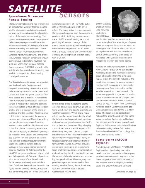
Pacific oceans and newly acquired data<br />
from QuikScat’s SeaWinds are shown in the<br />
figure (center column). The radar operates<br />
at a carrier frequency of 13.402 GHz with a<br />
10<br />
nominal peak power of 110 watts, pulse<br />
rate of 192 Hz and pulse width of 1.5<br />
m/sec. The highly stable receiver measures<br />
the return echo power from the ocean to a<br />
precision of 0.15 dB. Key measurements<br />
are a 1,800 km swath during each orbit<br />
providing 90 percent coverage of the<br />
Earth’s oceans every day, with wind speed<br />
measurement range from 3 to 30 m/sec<br />
with a 2 m/sec accuracy and wind direction<br />
accuracy of 20 degrees at a vector resolution<br />
of 25 km.<br />
Fifteen times a day, the satellite beams<br />
collected science data to NASA ground stations,<br />
which relay the data to scientists and<br />
weather forecasters. Winds play a major<br />
role in weather systems and directly affect<br />
the turbulent exchanges of heat, moisture<br />
and greenhouse gases between the Earth’s<br />
atmosphere and the ocean. They also play<br />
a crucial part in the scientific equation for<br />
determining long-term climate change.<br />
Data from SeaWinds’ two-year mission will<br />
greatly improve meteorologists’ ability to<br />
forecast weather and understand longerterm<br />
climate change. SeaWinds provides<br />
ocean wind coverage to an international<br />
team of climate specialists, oceanographers<br />
and meteorologists interested in discovering<br />
the secrets of climate patterns and improving<br />
the speed with which emergency preparedness<br />
agencies can respond to fastmoving<br />
weather fronts, floods, hurricanes,<br />
tsunamis and other natural disasters.<br />
Operating as NASA’s next<br />
El Nino watcher,<br />
QuikScat will be<br />
used to better<br />
understand<br />
global El Nino<br />
and La Nina weather abnormalities. A<br />
recent example of the advantages of spaceborne<br />
sensing was demonstrated when an<br />
iceberg the size of Rhode Island had elluded<br />
ship-borne and airborne surveillance<br />
devices and was drifting undetected off<br />
Antarctica until Quikscat located it and<br />
mapped its location (see figure above).<br />
Another on-orbit remote sensor is the US<br />
Navy GeoSAT Follow-On Ku-Band Radar<br />
Altimeter, designed to maintain continuous<br />
ocean observation from the GFO Exact<br />
Repeat Orbit. This satellite includes all the<br />
capabilities necessary for precise measurement<br />
of both mesoscale and basin-scale<br />
oceanography. Data retrieved from this<br />
satellite is useful for ocean research, offshore<br />
energy production, ocean circulation<br />
patterns and environmental change. GFO<br />
was launched aboard a TAURUS launch<br />
vehicle on Feb. 10, 1998, from Vandenberg<br />
Air Force Base in California and still provides<br />
valuable data sets for the U.S. Navy<br />
today. The radar uses co-boresighted<br />
radiometers, a <strong>Raytheon</strong> design, for water<br />
vapor correction. Radiometer calibration<br />
has become a niche area of research, and<br />
<strong>Raytheon</strong> holds several patents in calibrating<br />
radiometers using variable Cold Noise<br />
Sources based on MHEMT technology that<br />
have been validated at NIST.<br />
Space-borne SATCOM<br />
Payloads<br />
From Iridium to MILSTAR to FLTSATCOM,<br />
<strong>Raytheon</strong> has played a key role in the<br />
development of commercial military space<br />
satellite communications. <strong>Raytheon</strong> is the<br />
major supplier of UHF SATCOM products<br />
and services to the warfighter, including<br />
space and ground hardware, software,<br />
Continued on page 30