Parks, Recreation, Greenways, and Open Space ... - Town of Apex
Parks, Recreation, Greenways, and Open Space ... - Town of Apex
Parks, Recreation, Greenways, and Open Space ... - Town of Apex

You also want an ePaper? Increase the reach of your titles
YUMPU automatically turns print PDFs into web optimized ePapers that Google loves.
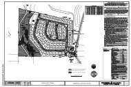
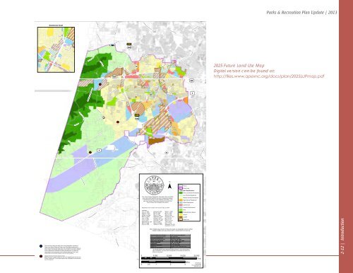
HUNTER ST2025 L<strong>and</strong> Use Plan<strong>Town</strong> <strong>of</strong> <strong>Apex</strong>, North Carolina<strong>Parks</strong> & <strong>Recreation</strong> Plan Update | 2013E FERRELL RDCHAP EL HILL RDCARPENTER UPCHURCH RDDowntown InsetN SALEM STGREEN LEVEL CHURCH RDHIGH HOUSE RDKW YNW CARY PNW MAYNARD RDWHITE OAK CHURCH RDUPCHURCH STCHATHAM STHOLLEMAN STHUGHES STCENTER STN MASON STCASTLEBERRY RDkGREEN LEVEL WEST RDROBERTS RDTOLL")540NC 55 HWYH OL T RDOL D APEX RDW WILLIAMS STSW CARY PKWYS SALEM STE WILLIAMS STHORTO N RDB ARKE R RDNEW HILL OLIVE CHAPEL RDAmerican Tobacco TrailkWIMBERLY RDUS 64 HWY W£¤ 64kkk£¤ 1RI C HARDSON RDHUMIE OLIVE RDOLD US 1 HWYOLIVE CHAPEL RDFRI ENDSHIP RDJENKS RDNC 540 HWYKELLY RDGREEN LEVEL CHURCH RDAPEX BARBECUE RDWOO DS CREEK RD")S SALEM ST55TOLL")540W WILLIAMS STOLD JENKS RDAPEX PEWYTINGEN RDOLD HOLLY SPRINGS APEX RDHUNTER STDAVIS DRAPEX PEWYSALEM CHURCH RDN SALEM ST")LAURA DUNCAN RDCENTER STE WILLIAMS STNC 55 BYPASS55OLD RALEIGH RDN MAIN STLAKE PINE DR£¤ 64£¤ 1TEN TEN RDSTEPHENSON RDSMITH RDPENNY RDKILDAIRE FARM RDSUNSET LAKE RDHOLLY SPRINGS RD2025 Future L<strong>and</strong> Use MapDigital version can be found at:http://files.www.apexnc.org/docs/plan/2025LUPmap.pdfUS 1 HWYNEW HILL HOLLEMAN RDHOLLY SPRINGS NEW HILL RDNEW HILL RDW HOLLY SPRINGS RDSHEARON HARRIS RD¯GB ALFORD HWYS MAIN STBASS LAKE RDParcelStudy AreaL<strong>and</strong> Use Classification:Very Low Density ResidentialAVEN T FERRY RDThe <strong>Town</strong> <strong>of</strong> <strong>Apex</strong> Geographic Information Services (GIS)shall not be held liable for any errors concerning contentor postitional accuracy <strong>of</strong> this mapped information. Theuser must consult the primary sources from which the<strong>Town</strong> <strong>of</strong> <strong>Apex</strong> GIS compiled this product.HONEYCUTT RDLow Density ResidentialMedium Density ResidentialN BROAD STHigh Density ResidentialOffice EmploymentkkThe mixed-use (<strong>of</strong>fice <strong>and</strong> retail) area in the southwestern quadrant <strong>of</strong>Green Level Church Road <strong>and</strong> Green Level West Road is planned forsmall scale <strong>of</strong>fice <strong>and</strong> retail uses which are compatible with the architecture,mass, height, <strong>and</strong> building relationships <strong>of</strong> the Green Level Historic District,so as to preserve the character <strong>of</strong> existing development, to protect thevisual pattern <strong>of</strong> the community, <strong>and</strong> to promote harmony in the visualrelationships <strong>and</strong> transition between new <strong>and</strong> older buildings.Neighborhood Commercial Activity Center:Market forecasts suggest viability for one to two Neighborhood CommercialActivity Centers only. Not all sites depicted are anticipated for developmentover the long term.BARTLEY HOLLEMAN RDCASS HOLT RDSWEET SPRINGS RDREX R DNC 42COKESBURY RDAdopted by <strong>Town</strong> <strong>of</strong> <strong>Apex</strong> <strong>Town</strong> Council: May 18, 2004Amended:June 15, 2004 February 6, 2007 March 17, 2009August 3, 2004 March 6, 2007 April 21, 2009August 17, 2004 May 15, 2007 May 19, 2009October 19, 2004 August 7, 2007 April 20, 2010March 15, 2005 September 4, 2007 February 15, 2011June 7, 2005 October 2, 2007 April 19, 2011June 21, 2005 November 20, 2007 May 10, 2011July 19, 2005 December 4, 2007 March 20, 2012September 20, April 15, 2008 June 5, 20122005March 7, 2006 August 19, 2008 July 17, 2012June 20, 2006 October 21, 2008 September 18, 2012December 18, 2012BUCKHORN DUNCAN RDCASS HOLT RDMIMS RDDUNCAN COOK RDROUSE RDBURT RDO C HESTER RDW ACADEMY STWADE NASH RDSPENCE FARM RDFLEMI NG RDTHREE PONDS DRPINEY GROVE WILBON RDWAGSTAFF RDOLD POWELL RDWILBON RDPHELPS WEST RDFLEMIN G LOO P RDCommercialIndustrial EmploymentParkProtected <strong>Open</strong> <strong>Space</strong>SchoolL<strong>and</strong>fillMixed UseNote: Striped areas that do not have the mixed use designation (brown outline)indicate multiple l<strong>and</strong> uses allowed with no requirement for mixed use.C OLEY FARM RDL<strong>and</strong> Use Plan Classification Allowable Zoning DistrictsVery Low Density Residential RA, RR, PUDLow Density ResidentialRA, RR, LD, PUDMedium Density ResidentialMD, PUD, MH, MHPHigh Density ResidentialHDSF, HDMF, PUD, TNDOffice EmploymentO&I, TF, PUD, MECCommercialB1, B2, PC, PUDIndustrial EmploymentLI, TF, PUD, MECMixed UseMORR*, PUD, TND, MEC, SD<strong>Parks</strong> <strong>and</strong> <strong>Open</strong> <strong>Space</strong>CB*The MORR (Mixed Office-Residential-Retail) District is only allowed where<strong>of</strong>fice, residential, <strong>and</strong> retail uses are depicted by the striped area within theMixed Use boundary.0 5,000 10,000 15,000 20,000Miles0 0.5 1 2 3S MAIN STHERBERT AKINS RDJAMES SLAUGHTER RDFeetPrepared by:<strong>Town</strong> <strong>of</strong> <strong>Apex</strong>Planning DepartmentDecember 20122-12 | Introduction