navis 3700 navis 3700 navis 3700 navis 3700 navis 3700 navis ...
navis 3700 navis 3700 navis 3700 navis 3700 navis 3700 navis ...
navis 3700 navis 3700 navis 3700 navis 3700 navis 3700 navis ...

You also want an ePaper? Increase the reach of your titles
YUMPU automatically turns print PDFs into web optimized ePapers that Google loves.
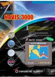
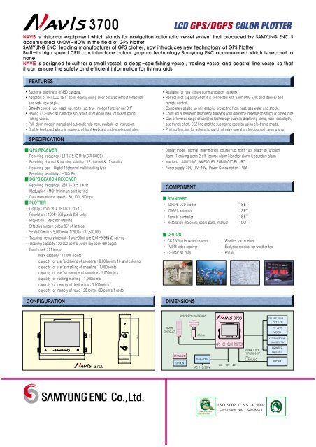
FEATURES<strong>3700</strong>LCD GPS/DGPS COLOR PLOTTERNAVIS is historical equipment which stands for navigation automatic vessel system that produced by SAMYUNG ENC’Saccumulated KNOW-HOW in the field of GPS Plotter.SAMYUNG ENC, leading manufacturer of GPS plotter, now introduces new technology of GPS Plotter.Built-in high speed CPU can introduce colour graphic technology Samyung ENC accumulated which is second tonone.NAVIS is designed to suit for a small vessel, a deep-sea fishing vessel, trading vessel and coastal line vessel so thatit can ensure the safety and efficient information for fishing aids. Supreme brightness of 450 candela. Adoption of TFT LCD 15.1”color display giving clear pictures without reflectionand wide view angle. Smooth course-up, head-up, north-up, true-motion function per 0.1。 Having 2 C-MAP NT cartridge slot which offer world map for ocean goingfishing vessel. Pull-down mode in manual and automatic help menu available for instruction. Double key board which is made up of front keyboard and remote controller. Available for new fishery communication network. Perfect pilot capacity(when it is connected with SAMYUNG ENC pilot device) andremote control. Completely sealed up unit enables protecting from heat, sea water and shock. Count actual navigation distance by displaying color difference. depends on straight or curved route. Can offer wide range of updated technology such as displaying slime, rock, sea depth,sea trench chart, EEZ line and the submarine cable by using electronic charts. Printing function for automatic switch of valve operation for disposal carrying ship.SPECIFICATION GPS RECEIVER∙ Receiving frequency : L1 1575.42 MHz(C/A CODE)∙ Receiving channel & tracking satellite : 12 channel & 12 satellite∙ Receiving type : Digital 12channel multi tracking type∙ Receiving sensitivity : -143dBm DGPS BEACON RECEIVER∙ Receiving frequency : 283.5~ 325.0 KHz∙ Modulation : MSK(minimum shift keying)∙ Data transmission speed : 50, 100, 200 bps PLOTTER∙ Display : color VGA TFT LCD (15.1”)∙ Resolution : 1024×768 pixels 256 color∙ Projection : Mercator drawing∙ Effective range : below 85。of latitude∙ Scale 0.2mile ~ 5,000 mile(1/2000~1/37,500,000)∙ Tracking memory interval : 1sec~60minute(0.01~9,99NM) set-up∙ Tracking capacity : 20,000 points , work log book (99 pages)∙ Event mark : 21 kindsMark capacity : 10,000 pointscapacity for user’s drawing of shoreline : 8,000points 16 land coloringcapacity for user’s marking of shoreline : 1,000pointscapacity for user’s character of shoreline : 1,000pointscapacity for tracking marking : 1,000pointscapacity for memory of destination : 1,000pointscapacity for memory of route : 20 routes (20 points/1 route)CONFIGURATION∙ Display mode : normal, true-motion, course-up, north-up, head-up function∙ Alarm 1)arriving alarm 2)off-course alarm 3)anchor alarm 4)boundary alarm∙ Interface : SAMYUNG, NMEA0183, FURUNO(CIF), JRC∙ Power supply : DC 10V~40V, Power Consumption : 40WCOMPONENT STANDARD∙ (D)GPS LCD plotter∙ (D)GPS antenna∙ Remote controller∙ Installation materials, spare parts, manual OPTION∙ CCTV/under water camera∙ TV/FM video receiver∙ C-MAP NT mapDIMENSIONS1SET1SET1SET1LOT∙ Weather fax receiver∙ Exclusive receiver for weather fax∙ Printer406.0 110.0GPS/DGPS ANTENNA<strong>3700</strong>under water camera 1CCTV 3426.0327.0<strong>3700</strong>110.0115.0349.0REMOTECONTROLLERSTANDARDOPTIONRG-58USAN-130AAC 110/220VGPS LCD COLOR PLOTTERNMEA 0183FURUNO(CIF)JRCSAMYUNGDC+10V~40VTV ANTVIDEOExclusive receiverfor weather faxPRINTERDPU-414RADARISO 9002 / KS A 9002Certificate No. : QSC92073