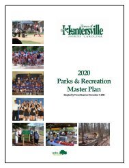
History of the Town of Huntersville
History of the Town of Huntersville
History of the Town of Huntersville

You also want an ePaper? Increase the reach of your titles
YUMPU automatically turns print PDFs into web optimized ePapers that Google loves.
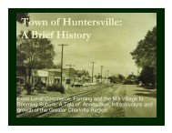
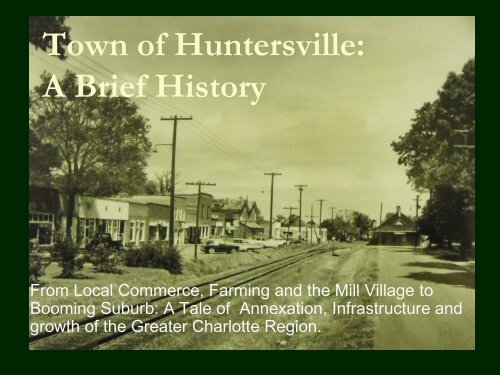
<strong>Town</strong> <strong>of</strong> <strong>Huntersville</strong>:A Brief <strong>History</strong>From Local Commerce, Farming and <strong>the</strong> Mill Village toBooming Suburb: A Tale <strong>of</strong> Annexation, Infrastructure andgrowth <strong>of</strong> <strong>the</strong> Greater Charlotte Region.
Early Settlers Connected to Local Churches• Most <strong>of</strong> <strong>Huntersville</strong>’s early communities(farm land) developed around churchesRamah Presbyterian ChurchCaldwell Station (Mayes Rd.) – Rail stopGilead Community (ARP church)Hopewell Presbyterian (Beatties Ford Rd.)St Marks Episcopal (Mt Holly/<strong>Huntersville</strong>)Catawba Presbyterian – <strong>the</strong> original site is underLake Norman near where Southlake Academy istoday (it now resides <strong>of</strong>f McCoy Rd. and itscemetery remains <strong>of</strong>f Brown Mill Road)
<strong>Huntersville</strong> from a Postal Perspective• <strong>Huntersville</strong> covered everything East <strong>of</strong><strong>the</strong> Catawba River into Cabarrus County• It stretched South from Cornelius’s1900’s town limit to Harris Blvd/I-85• <strong>Town</strong> went south along Beatties Ford Rd.past Long Creek to Sunset Road.• As far east to include Mallard Creek,including all <strong>of</strong> Eastfield Road.
<strong>Huntersville</strong> through <strong>the</strong> 1900s• <strong>Town</strong> renamed to <strong>Huntersville</strong> from Craighead(local minister) for prominent “Hunter” family• <strong>Town</strong> was 1 square mile (railroad at its center)Main Street – stores, bank, laundromat<strong>Town</strong> limit was just west <strong>of</strong> Dallas St. (across from<strong>Huntersville</strong> Elementary School)• Early housing (pre-1950) were custom built bylocal men (farmers, carpenters, bricklayers,etc.)• Most paid cash or got loans from <strong>the</strong> Bank <strong>of</strong>Cornelius, which had a branch in downtown<strong>Huntersville</strong>
A Look Back at Downtown <strong>Huntersville</strong>• Cross Chevrolet (<strong>Town</strong> Center)• Bus stop (where Fire Station is today)• Auten Ford (NC115/Mt Holly-<strong>Huntersville</strong>)• General Store on Maxwell/<strong>Huntersville</strong>-ConcordRd. (burned to <strong>the</strong> ground)• Banks• 2 GroceryStores
A Look Back at Downtown <strong>Huntersville</strong>• Doctor Craven’s Office and Pharmacy (Lupie’s)• Neil’s Drug Store (where Lupie’s is today)• Lane Clothing Store (same block as Lupie’s, lived whereCafe 100 is today)• A 2 nd doctor located on Gilead (west <strong>of</strong> DPK)
The Early Economy• After WWI, Duke Powerand Bellsouth were <strong>the</strong>prominent employers.• After WWII, nearly allfamilies had at least onefamily member workingin Charlotte –DukePower, Bellsouth, at one<strong>of</strong> <strong>the</strong> banks, in general<strong>of</strong>fice work, at <strong>the</strong>hosiery mills or teaching.
Area Jobs• Former Anchor Mill site, east <strong>of</strong> railroad• Most people who worked in <strong>the</strong> mill lived around <strong>the</strong>mill• O<strong>the</strong>r <strong>Huntersville</strong> families lived and worked onfarms, in community commerce (retail/commercial)jobs or in Charlotte.• Prison Camp and Highway Maintenance yard waslocated on Mt Holly-<strong>Huntersville</strong> Road – behindwhere <strong>the</strong> Park is today and owned by NCDOT(helped get state and county roads cleanedregularly, though <strong>the</strong>re weren’t many at <strong>the</strong> time.)
The Early EconomySome families moved to <strong>Huntersville</strong> for <strong>the</strong>irchildren to go to Grey’s Academy (whereHES is today)
1950s Development• <strong>Town</strong>’s first subdivision: GreenfieldLower Greenfield – divided and sold to individualsUpper Greenfield – Dallas and Hillcrest Streets, laid out like asubdivision• Developed under <strong>Town</strong>’s first planning / zoning ordinance tocontrol type <strong>of</strong> development in area• <strong>Town</strong> expanded to strip shopping center whereCaptains Galley is today – voluntary annexation inlate 50s. <strong>Town</strong>’s first involuntary annexation came many years later –land along Sam Furr Road (including Cambridge Grove andGreenfarm to NC73/Catawba Ave near <strong>the</strong> Breckenridgearea
A Snapshot from <strong>the</strong> 1950’s“<strong>Huntersville</strong>, 13 milesnorth <strong>of</strong> Charlotte on <strong>the</strong>Statesville highway, No.21, is currently in <strong>the</strong>spotlight as perhaps <strong>the</strong>only municipality in <strong>the</strong>United States whoseevery foot <strong>of</strong> streets ispaved.”The <strong>Town</strong> has been referredto by speakers and inwritten notices as <strong>the</strong>municipality in NorthCarolina having <strong>the</strong> largestpercentage <strong>of</strong> collegetrained citizens.<strong>Huntersville</strong> wasalso one <strong>of</strong> <strong>the</strong> firstcommunities inrural Mecklenburgto obtain modernfacilities, includingelectricity andwater.“The town has anexcellent financialrating with a lowindebtedness andample revenue tohandle itsobligations. Thecurrent tax rate is$1.
Western <strong>Huntersville</strong>• West side (<strong>of</strong> NC-115)developed first• Primarily because <strong>of</strong> waterfrom <strong>the</strong> lake• Intake on Lake Norman1 st water treatment plant waswhere Regency Village is today.<strong>Huntersville</strong> supplied water todevelopers along NC73 andLake Norman for developmentoutside <strong>Huntersville</strong> <strong>Town</strong> limits.
Water and Sewer Feeds Growth• In 1979, hooked into McDowell Creek regionalwastewater system• Anything west <strong>of</strong> <strong>the</strong> railroad was gravity-fedRamah Church to <strong>Huntersville</strong>-Concord (East <strong>Huntersville</strong>) hadsewer – to <strong>the</strong> <strong>Huntersville</strong> water treatment plant out GibsonPark Drive (Vermillion) to Clark Creek.• CMU converted it from a treatment plant to a lift stationand pumps it across <strong>the</strong> railroad out to <strong>the</strong> treatmentplant <strong>of</strong>f Neck Rd. (where it is today).• 75% <strong>of</strong> cost paid by <strong>the</strong> Federal government and12.5% each by <strong>the</strong> State and Mecklenburg County.• Some areas developed with Septic – such asWestminster Park (<strong>of</strong>f MH-H at <strong>Town</strong>’s sou<strong>the</strong>rn edge)
Residential Development in <strong>the</strong> 1980s• Shepherd’s Vineyard<strong>Town</strong>’s second subdivision (just north <strong>of</strong> <strong>the</strong>downtown area, <strong>of</strong>f NC-115)Developed in <strong>the</strong> 1980s• BreckenridgeProposed at <strong>the</strong> same time (<strong>of</strong>f NC73 – DavidKenney Farm Rd./Birkdale Area)
<strong>Huntersville</strong> Business Park Sparks Growth• Now known as “The Park – <strong>Huntersville</strong>”• Created in <strong>the</strong> 80’s by NCNB (now Bank <strong>of</strong>America) – land <strong>of</strong>f Gilead Road was not intown limits at <strong>the</strong> time.• First tenant was an Ace Hardware distributioncenter – large building on south area <strong>of</strong>Reese Blvd.• Old rock quarry backs up to Park (<strong>of</strong>f MH-H)• Created need for housing for managers andexecutives
W/S Spurs Residential Growth• Cedarfield, Wynfield Creek and Wynfield Forest werebuilt in <strong>the</strong> late 80’s to mid 90’s.• MacAulay was built in <strong>the</strong> early 2000’s.• On NC73, Greenfarm was <strong>the</strong> first, followed byCambridge Grove and <strong>the</strong> Hamptons as W/Sexpanded• No sewer to <strong>the</strong> east <strong>of</strong> Vermillion and Centennial,limiting fur<strong>the</strong>r development• Ramah Creek – important as it will providewater/sewer along <strong>the</strong> rail road for future economicdevelopment, which is why <strong>the</strong>re’s a creek overflow inNorthstone
Residential Development in <strong>the</strong> 1990s• Group <strong>of</strong> area business people saw need forhousingGreenfarm had already been built at this point.Land was bought for Wynfield and Cedarfield in <strong>the</strong>late 80s / early 90s• Power neighborhoods <strong>of</strong> <strong>the</strong> 1990s• Annexed into town through <strong>the</strong> 90s, large part<strong>of</strong> exponential growth
Schools• North Mecklenburg opened in 1951, firstclass graduated in 1953• Served Long Creek, Davidson, Cornelius, <strong>Huntersville</strong>and Derita• District went beyond North Tryon St. because Garingerhadn’t been built yet.• Torrence-Lytle School• Known as <strong>the</strong> <strong>Huntersville</strong> Colored School until 1952-53)• Built in 1937, closed in 1966• Students integrated into North Meck HS in 1965• Hopewell High School opened in 2001
Schools• J.M. Alexander Junior High built in <strong>the</strong> 1960s• Later Bradley Middle opened on <strong>the</strong> west side• <strong>Huntersville</strong> Elementary School• Former home <strong>of</strong> <strong>Huntersville</strong> High Schooland <strong>Huntersville</strong> Academy• Ag buildings still standing at HES and Long Creek.• Elementary Schools developed as population grew• Bly<strong>the</strong> Elementary• Torrence Creek and Barnette Elementary Schools opened inpast 10 years• O<strong>the</strong>r options also opened as Lake Norman Charter(now grades 5-12) began in 1998-1999.
Highways / Interstate• NC 115 used to be US 21, was moved in <strong>the</strong>late 1950s to where US21 is now.When ROW for 21 was purchased, landownerswere told it was also for I-77• Two 150 year old homesteads were taken for 21/77 (poorhistoric preservation)• 1975: I-77 completed from Charlotte to Elkin• Rail line didn’t transport residents from<strong>Huntersville</strong>/North Mecklenburg after WWII,though it continued carrying freight.• 2 Exits fuel access and growth
Exit 25 – 1993 Aerial (Exit opened in 1994)
Exit 25 – 2007 Aerial
The Lake• Duke Power finished <strong>the</strong> Cowans Ford Dam on <strong>the</strong>Catawba River, <strong>of</strong>ficially creating Lake Norman in1963.• The largest manmade body <strong>of</strong> fresh water in NorthCarolina 1963 – 520 miles <strong>of</strong> shoreline.• Lake named for Duke Power president NormanCocke.• Big impact on growth <strong>of</strong> area, however through <strong>the</strong>1980s, many people only had weekend/vacationhomes on <strong>the</strong> lake.It wasn’t until <strong>the</strong> 90s/2000s that development intensified.It also wasn’t always socially acceptable for many <strong>of</strong> <strong>the</strong>execs that call LKN home today to live north <strong>of</strong> I-85.
Early Public Safety• Police – from 1 to nearly 80+today• Volunteer Fire Departmentssettled around communities(<strong>Huntersville</strong>, Gilead, LongCreek, etc.)• <strong>Huntersville</strong> Fire Dept – attribute alot to Chief Allen Irvin andAssistant Chief Dwight Cross, Jr.– <strong>the</strong> staff from Cross Chevroletwould answer calls during <strong>the</strong> day(Chief John Albert Rape, killed in<strong>the</strong> line <strong>of</strong> duty – Jan. 1, 1938.)
Early Public Safety• The North MecklenburgVolunteer Rescue Squad wasfounded in 1959 in <strong>the</strong> town <strong>of</strong><strong>Huntersville</strong>, North Carolina. Thesquad was established andstaffed by members <strong>of</strong> <strong>the</strong>nor<strong>the</strong>rn Mecklenburg Countycommunities in order to provideambulance and rescue servicesto nor<strong>the</strong>rn Mecklenburg Countyincluding <strong>the</strong> communities <strong>of</strong>Cornelius, Davidson, Gilead,Long Creek, and <strong>Huntersville</strong>.(training exercise from 1960s)
O<strong>the</strong>r Historical Sites <strong>of</strong> Note• Historic Latta Plantation• Rural Hill• Hugh Torrance House and Store• EnergyExplorium at McGuire Nuclear Station• Hopewell Presbyterian Church• Beatties Ford Road Corridor• Torrence-Lytle School