Landuse - Calaveras County Government Services
Landuse - Calaveras County Government Services
Landuse - Calaveras County Government Services

You also want an ePaper? Increase the reach of your titles
YUMPU automatically turns print PDFs into web optimized ePapers that Google loves.
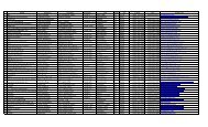
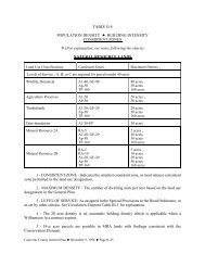
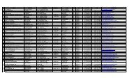
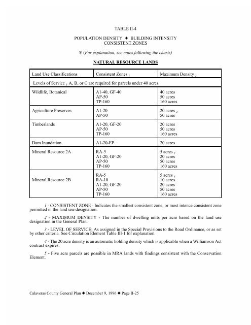
TABLE II-4POPULATION DENSITY J BUILDING INTENSITYCONSISTENT ZONES_ (For explanation, see notes following the charts)NATURAL RESOURCE LANDSLand Use Classifications Consistent Zones 1 Maximum Density 2Levels of Service 3 A, B, or C are required for parcels under 40 acresWildlife, BotanicalA1-40, GF-40AP-50TP-16040 acres50 acres160 acresAgriculture Preserves A1-20AP-5020 acres 450 acresTimberlandsA1-20, GF-20AP-50TP-16020 acres50 acres160 acresDam Inundation A1-20-EP 20 acresMineral Resource 2AMineral Resource 2BRA-5A1-20, GF-20AP-50TP-160RA-5RA-10A1-20, GF-20AP-50TP-1605 acres 520 acres50 acres160 acres5 acres 510 acres20 acres50 acres160 acres1 - CONSISTENT ZONE - Indicates the smallest consistent zone, or most intence consistent zonepermitted in the land use designation.2 - MAXIMUM DENSITY - The number of dwelling units per acre based on the land usedesignation in the General Plan.3 - LEVEL OF SERVICE: As assigned in the Special Provisions to the Road Ordinance, or as setby other criteria. See Circulation Element Table III-1 for explanation.4 - The 20 acre density is an automatic holding density which is applicable when a Williamson Actcontract expires.5 - Five acre parcels are possible in MRA lands with findings consistent with the ConservationElement.<strong>Calaveras</strong> <strong>County</strong> General Plan z December 9, 1996 z Page II-25