
Create successful ePaper yourself
Turn your PDF publications into a flip-book with our unique Google optimized e-Paper software.
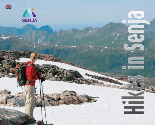
<strong>Hikes</strong> <strong>in</strong> <strong>Senja</strong>
View from Breit<strong>in</strong>d©BSLeikvika©HPP<strong>Senja</strong> på langs©EMThe adventurer <strong>in</strong> <strong>Senja</strong>Langdalsvatnet©JOG2Hike <strong>in</strong> <strong>Senja</strong><strong>in</strong> peaceful <strong>in</strong>ner calmwith a keen eye, and open m<strong>in</strong>d -and amazement -between the blue yonder andwide open spaces<strong>Senja</strong> is full of contrasts,most of which are close byIt’s never far from the coast to the mounta<strong>in</strong>s <strong>in</strong> <strong>Senja</strong>,from steep mounta<strong>in</strong>s between narrow fjordsto birch-covered mounta<strong>in</strong>sides and p<strong>in</strong>e ridges,from lowland and waste level perennials,to high mounta<strong>in</strong>s and crustose lichens underwell worn hik<strong>in</strong>g boots.Hik<strong>in</strong>g <strong>in</strong> <strong>Senja</strong> is hik<strong>in</strong>g <strong>in</strong> an adventure.<strong>Senja</strong> is the adventure island.The hiker is the explorer, the adventurer.
Northern Wheatear©JOGStormoa©RSÅnderdalen©EMHik<strong>in</strong>g <strong>in</strong> <strong>Senja</strong>©EMFirstly, a bit about be<strong>in</strong>g a hikerFor the hiker, it is often about be<strong>in</strong>g prepared for the different challengesyou may encounter and to rema<strong>in</strong> with<strong>in</strong> your own physical limitations. Itis important not to set off on long, demand<strong>in</strong>g hikes if this exceeds yourcurrent fitness level. The recommendations about grad<strong>in</strong>g of levels forthe various hikes are designed for <strong>in</strong>formation purposes only as differenthikers have different perceptions of what makes a hike demand<strong>in</strong>g.Always ensure you are properly equipped for your hike. A map andcompass are necessary on longer hikes when you are cross<strong>in</strong>g baremounta<strong>in</strong>s and leav<strong>in</strong>g marked trails. Cold weather, ra<strong>in</strong> and mist arepossible regardless of the season, and you will also encounter differentsurfaces, rang<strong>in</strong>g from dry and stony to marshland. Consequently, it’simportant to choose cloth<strong>in</strong>g and footwear so you are equipped forchang<strong>in</strong>g conditions. The longer the hike, the more important it is to takesuch th<strong>in</strong>gs <strong>in</strong>to consideration.Happy hik<strong>in</strong>g!3
Natur på <strong>Senja</strong> - fra hav til hav<strong>Senja</strong> – from coast to coastWe often say that the nature on the island of <strong>Senja</strong> is a cross-section of Norwegian nature – a Norway <strong>in</strong> m<strong>in</strong>iature. On the “<strong>in</strong>ner coast”and <strong>in</strong> the south, you will discover a gentle landscape with marshland, p<strong>in</strong>e forests and forested hillsides. When we cross <strong>Senja</strong> towardsthe west and north, the landscape rises through mounta<strong>in</strong> birch forests, cross<strong>in</strong>g tree-less mounta<strong>in</strong>s and barren, high mounta<strong>in</strong>s beforeit drops suddenly down towards the open sea on the “outer coast”. The tree-l<strong>in</strong>e is at about 300 m above sea level.The road from Gryllefjord to Botnhamn twists and turns along the outer coast of <strong>Senja</strong> and is part of the National Tourist Routes.THE LANDSCAPEGeology and mounta<strong>in</strong>sThe bedrock on <strong>Senja</strong> is mostly granite, which wasformed about 1.7 billion years ago. Over the past twomillion years, there have been about 40 ice ages, whichhas left its mark on the island. In many places, we canf<strong>in</strong>d glacial rocks, which rema<strong>in</strong>ed when the glaciers receded.We can f<strong>in</strong>d stalactites along the beaches, whichoften lay directly on the clayish bottom, <strong>in</strong>dicat<strong>in</strong>g theyorig<strong>in</strong>ate from thrust sheets.Around 15,000 years ago, most of <strong>Senja</strong> was coveredby a 300 m thick ice cap. Ow<strong>in</strong>g to the weight of theice, the landscape was pressed down about 100 m <strong>in</strong>relation to today’s level. The ice receded <strong>in</strong> legs creat<strong>in</strong>gshorel<strong>in</strong>es and pebble beaches at different levels. Theseshorel<strong>in</strong>es rema<strong>in</strong> clear <strong>in</strong> many locations <strong>in</strong> <strong>Senja</strong>, bothon the outer and <strong>in</strong>ner coasts.While naked bedrock dom<strong>in</strong>ates <strong>in</strong> the mounta<strong>in</strong>s, thedepressions and valleys are covered by deposits leftfrom the glaciers. The sand dunes and beach ridges(grass-covered sand dunes) <strong>in</strong> the Ersfjorden enable usto study the storm surge climate through the past 7000years. There are also areas <strong>in</strong> <strong>Senja</strong> with many giantkettles.4With many of the mounta<strong>in</strong>s ris<strong>in</strong>g directly from sealevel, many of <strong>Senja</strong>’s mounta<strong>in</strong>s give a majestic impression.<strong>Senja</strong>’s highest mounta<strong>in</strong> is Mount Breit<strong>in</strong>d atthe head of the Mefjorden, which is 985 m above sealevel. Mount Kvænan <strong>in</strong> ÅnderdalenLakes and watercoursesTypical of the variations on the island of <strong>Senja</strong> is theabundance of lakes, rivers, waterfalls and rapids. Mostof the watercourses are situated on <strong>Senja</strong>’s <strong>in</strong>ner coast,and many offer good conditions for freshwaterfish<strong>in</strong>g and other nature-based activities. Small andmedium-sized rivers create beautiful waterfalls downthe mounta<strong>in</strong>sides. The largest waterfall visible from theroad is created by a 60 m high waterfall <strong>in</strong> the <strong>in</strong>nermostpart of the Gjeskadalen valley.FLORA<strong>Senja</strong>’s vegetation covers the range between clearoceanic features with coniferous forest to typical Arcticfeatures above the climatic tree-l<strong>in</strong>e. We also f<strong>in</strong>d thewhole spectrum of marshes from “bottomless” marshsumps and well-developed ground marshes to shallowmarshes that cover the countryside and damp forestfloors. The marshes or bogs have both direct and <strong>in</strong>directsignificance for the biodiversity, and many speciesare connected to the marshes.The virg<strong>in</strong> forest of coastal p<strong>in</strong>e <strong>in</strong> the ÅnderdalenNational Park is rare for Northern Norway. You can alsodiscover areas of relatively untouched and large birchforests <strong>in</strong> and adjacent to the national park.As a result of the rais<strong>in</strong>g of the land level after the lastIce Age, you will f<strong>in</strong>d earlier sea floors <strong>in</strong> the valleyswhere some calcium-demand<strong>in</strong>g species grow.FAUNAAs <strong>Senja</strong> is an island, there are not so many mammalspecies here. The only large mammals are the domesticatedre<strong>in</strong>deer and moose. Predatory animals <strong>in</strong>cludethe red fox, stoat, m<strong>in</strong>k and otter. The most commonsmall rodents are found here and some years there arelarge quantities of lemm<strong>in</strong>g. The only amphibian speciesfound here is the common frog.Trout and Arctic char are found <strong>in</strong> the rivers, streamsand lakes. The three-sp<strong>in</strong>ed stickleback is found <strong>in</strong> someplaces, while salmon, sea trout and sea char are found<strong>in</strong> some watercourses.Such landscape and vegetation leaves its mark on theflora and is also of significance for the birdlife. Fromthe seashore to the mounta<strong>in</strong>s of <strong>Senja</strong>, you will f<strong>in</strong>dthe bird species you would expect to f<strong>in</strong>d <strong>in</strong> other partsof Troms County. Along the hik<strong>in</strong>g trails, you may encounterseveral of our birds of prey, but also the mostcommon owl species. There are also many species ofducks, wad<strong>in</strong>g birds and passer<strong>in</strong>e birds.Ånderdalen Natonal park©EMView from Første Svanfjell©JOG
Veidmannsfjorden©HPP5
NdecaTrails <strong>in</strong> <strong>Senja</strong>LEGSA) Lake Lysvatnet – Trondalen valleyB) Trondalen valley – LakeBumannsvatnetC) Lake Bumannsvatnet – LakeÅndervatnetD) Lake Åndervatnet – OlaheimenCONNECTING TRAILS1) Svartholla – Lake Lysvatnet2) Sandbakken – Heggtuva3) Gryllefjordbotn – Leirdalen valley4) Gjeska – Lake Sør Kapervatnet5) Tranøybotn – Lake ÅndervatnetYou will f<strong>in</strong>d descriptions of the othertrails (marked a-t) on pages 16-18.As detailed routes are not provided <strong>in</strong>this brochure, the map cannot be used<strong>in</strong>stead of a topographic hik<strong>in</strong>g map.sjimnkilo864f3DgCÅnderdalenNational ParkB8608625hph86b1A2qtqr862861F<strong>in</strong>nsnes6
<strong>Senja</strong> på langsThe <strong>Senja</strong> på langs (<strong>Senja</strong> from north to south) route has for many years been popularamong hikers want<strong>in</strong>g to see and experience <strong>Senja</strong>’s nature. The terra<strong>in</strong> and nature isextremely varied, provid<strong>in</strong>g a wide variety of experiences. The hike from the slightlyrugged and wild nature of North <strong>Senja</strong> to the gentle landscape of South <strong>Senja</strong> provides across-section of Norwegian nature.Trondalen©JOGThe trail goes from the power station at LakeLysvatnet <strong>in</strong> the north to Olaheimen, whichis between the lakes of Store Bunkevatn andRødsandvatnet, <strong>in</strong> the south. The total distanceis around 70 km, and the trail is <strong>in</strong>dicatedby red markers. Ow<strong>in</strong>g to the topography,hikers embark<strong>in</strong>g on the full route are highlyrecommended to start <strong>in</strong> the north and end <strong>in</strong> thesouth.The level of the trail is varied. However, theterra<strong>in</strong> is not regarded as rough <strong>in</strong> some places,even though there are some isolated steepsections along one of the legs. Protectiveequipment is not required and anyone with anormal level of fitness can complete all the legs.In this description, we have divided the routeup <strong>in</strong>to several <strong>in</strong>dependent legs, where thestart and f<strong>in</strong>ish po<strong>in</strong>ts can be reached from theroad. It is possible to complete the legs as dayhikes, although at least one overnight stop isrecommended for the longest legs.<strong>Senja</strong> Turlag (hik<strong>in</strong>g association) recommends thefollow<strong>in</strong>g day legs for hikers want<strong>in</strong>g to completethe entire route <strong>in</strong> one go:Day 1: Power station at Lake – <strong>Senja</strong>bu cab<strong>in</strong>Day 2: <strong>Senja</strong>bu cab<strong>in</strong> – Lake Sør KapervatnetDay 3: Lake Sør Kapervatnet – Lake LutvatnetDay 4: Lake Lutvatnet – Olaheimen, “Thecharm<strong>in</strong>g leg”The hik<strong>in</strong>g association’s recommended legs arebased on the accommodation options and campsites. The <strong>Senja</strong>bu cab<strong>in</strong> is used on the first nightso hikers can sleep <strong>in</strong>side, while Lake Kapervatnetand Lake Lutvatnet are recommended becausemany good tent sites are available <strong>in</strong> these areas.You will discover many lakes en route which areideal for fish<strong>in</strong>g, so we advise hikers who are alsokeen fishermen to br<strong>in</strong>g their fish<strong>in</strong>g gear withthem.7
A) Power station atLysvatnet – TrondalselvaApprox. 20 kmB) Trondalselva –Bumannsvatnet <strong>in</strong>Kaperdalen Approx. 13 kmThe legs<strong>Senja</strong> på langsHighest po<strong>in</strong>t: Heggtuva approx. 320 m abovesea levelView po<strong>in</strong>ts (ma<strong>in</strong> route): Heggtuva – view ofthe Nord Heggdalen valley to the east and SørHeggdalen valley to the westView po<strong>in</strong>t (alternative route): Bratthaugen (731m above sea level) – view towards Straumsbotn,Svandalen, Lars-Larsadalen and GrasmyrLevel: Easy terra<strong>in</strong>, mostly <strong>in</strong> forest with a gradualclimb up Heggtuva. Some virg<strong>in</strong> forest andfern-dom<strong>in</strong>ated areas <strong>in</strong> the far west of the SørHeggdalen valleyCampsite/accommodation: Hut <strong>in</strong> the Heggdalenvalley after about 5 kmThe trail goes directly south about a kilometre southof the power station by the Helvetesfossen waterfallbefore it w<strong>in</strong>gs to the west through the NordHeggdalenValley and follows the valley on the northernside of the Heggelva River. Lake Heggvatnet, which issituated about halfway <strong>in</strong>to the valley, is a good lake forfish<strong>in</strong>g with stocks of Arctic char. About 5 km from thepower station is a hut owned by Statskog and run byIndre <strong>Senja</strong> Jeger- og fiskeforen<strong>in</strong>g (hunt<strong>in</strong>g and fish<strong>in</strong>gsociety). It is open for accommodation and has basiccook<strong>in</strong>g facilities, cutlery, crockery etc. and mattresses <strong>in</strong>bunk beds. The trail through the Nord Heggdalen valleyis easy forest terra<strong>in</strong>.From Heggtuva, you may choose between two routes.The ma<strong>in</strong> route follows the Sør Heggdalen valley <strong>in</strong>easy terra<strong>in</strong> until you reach the Trondalselva River. Thealternative route goes from Heggtuva across Bratthaugenand down to <strong>Senja</strong> Turlag’s <strong>Senja</strong>bu Cab<strong>in</strong> <strong>in</strong>the Svandalen valley. Most of this route is situated <strong>in</strong>tree-less mounta<strong>in</strong>s. This is a medium level route. Thesteepest part is from Heggtuva up to the highest po<strong>in</strong>tof Bratthaugen. This route is unmarked, but it is easy tof<strong>in</strong>d as you can at all times follow the mounta<strong>in</strong> ridgebetween the summit and the Svandalen valley. Thedistance from Heggtuva to <strong>Senja</strong>bu is about 8 km.8Leirdalen©JOGHighest po<strong>in</strong>t: Approx. 400 m above sea level atthe divide between the Trondalen and LeirdalenvalleysView po<strong>in</strong>ts: From the Leirdalen valley we havea good view of Lake Store Ostervatnet and MountKeipen (661 m above sea level). To the west, wecan see Mount Skipst<strong>in</strong>d (715 m above sea level)and to the north-west Mount Skreflåget (869 mabove sea level).Level: Medium, some dense forest <strong>in</strong> theLeirdalen valleyCampsite/accommodation: <strong>Senja</strong> Turlag’s<strong>Senja</strong>bu cab<strong>in</strong> on FV86. There are good sites forpitch<strong>in</strong>g tents <strong>in</strong> the Trondalen and Leirdalenvalleys.This route follows the Trondalen valley <strong>in</strong> easy forestterra<strong>in</strong>. The trail is well marked <strong>in</strong> the section betweenTrondalen and the <strong>Senja</strong>bu cab<strong>in</strong>.The trail across the divide between the Trondalen andLeirdalen valleys crosses dry and easy terra<strong>in</strong>. Thetrail through the Leirdalen valley cont<strong>in</strong>ues at altitudethrough forest terra<strong>in</strong> on the eastern side of the valley.Between Leirdalen and Lake Bumannsvatnet, the routefollows the southern side of Lake Langdalsvatnet.In the Leirdalen valley, there are also good camp<strong>in</strong>gsites by the river pool at the waterfall flow<strong>in</strong>g downfrom Lake Leirskarvatnet.Mt Keipen with Fjordgård and Husøy <strong>in</strong> the background©GG
C) Bumannsvatnet – ÅndervatnetApprox. 17 kmD) Åndervatnet –OlaheimenApprox. 24 kmThe legs<strong>Senja</strong> på langsFrom Ist<strong>in</strong>den©TRAlternative route Lake Bumannsvatnet – Lake SørKapervatnet – Gjeska (connect<strong>in</strong>g trail 4). Instead of cont<strong>in</strong>u<strong>in</strong>g from the ford across theÅnderelva River to Olaheimen, you can hike down toTranøybotn (connect<strong>in</strong>g trail 5).Highest po<strong>in</strong>t: Approx. 800 m above sea level <strong>in</strong>the pass below Mount Ist<strong>in</strong>d.View po<strong>in</strong>ts: Short detour to Mount Ist<strong>in</strong>d (851 mabove sea level)The steepest sections along the entire <strong>Senja</strong> på langsroute are on this leg. The longest ascent is betweenthe Kaperdalen valley (364 m above sea level) and theroute’s highest po<strong>in</strong>t below the summit of Mount Ist<strong>in</strong>d(about 800 m above sea level). The climb is somewhateasier if you choose to follow the route that passes overthe road tunnel <strong>in</strong>stead of straight up the mounta<strong>in</strong>side.The view from the summit of Mount Ist<strong>in</strong>d (851m above sea level) is exceptional, and we highlyrecommend mak<strong>in</strong>g a detour to the top. In the passbeneath Mount Ist<strong>in</strong>d, you cross the boundary ofÅnderdalen National Park. The section down towardsLake Rundvatnet <strong>in</strong> the Helvetesdalen valley issomewhat steeper, but much shorter. It can be slipperyhere <strong>in</strong> wet weather.The section between Lake Bumannsvatnet and LakeKapervatnet (214 m above sea level) can be extremelydemand<strong>in</strong>g <strong>in</strong> w<strong>in</strong>ter as hard chasms often form <strong>in</strong> themounta<strong>in</strong>sides here.The trail between Lake Sør Kapervatnet and LakeRundvatnet (244 m above sea level) <strong>in</strong> the Helvetesdalvalley goes through easy terra<strong>in</strong>. Part of the trail along10Helvetesdalen©EMLevel: Steep up from FV243. Somewhat roughon the highest parts of the trail and can also beextremely exposed. Pay particular attention <strong>in</strong> fog!Keep away from the canyon <strong>in</strong> the Kaperelva Riverdown towards Lake Åndervatnet. There is somedense undergrowth along Lake Kapervatnet.Campsite/accommodation: There is a gapahuk(rustic shelter) with firewood on the northern sideof the river near the ford and a gamme (turf hut)on the southern side of Lake Åndervatnet.Lake Kapervatnet is through thick scrub. The sectionof the trail between Lake Kapervatnet and LakeÅndervatnet, along the banks of the Kaperelva River,you encounter the ancient coastal p<strong>in</strong>e forest for whichthe national park is known.The river between Lake Sør Kapervatnet and LakeÅndervatnet cuts <strong>in</strong>to the mounta<strong>in</strong> creat<strong>in</strong>g a deepcanyon.The trail follows along the northern and eastern sides ofLake Åndervatnet (110 m above sea level).It is possible to wade across the river at the outlet ofLake Åndervatnet. However, dur<strong>in</strong>g flood<strong>in</strong>g you needto follow the river about 1 km downstream to a moresuitable ford where the river is wide and shallow. Thisford is well marked.On the southern side of Lake Åndervatnet, Statskoghas a gamme (turf hut) sleep<strong>in</strong>g four. This turf hut isalways open and conta<strong>in</strong>s the most essential cook<strong>in</strong>gequipment. The area between the Ånderelva River andthe turf hut is boggy.Lutvatnet©KNHighest po<strong>in</strong>t: Approx. 500 m above sea level <strong>in</strong> thepass between Mount Blåfjellet and Mount Jøvikfjellet,and 475 m above sea level between Lake Re<strong>in</strong>livatnetand the F<strong>in</strong>nskaret PassView po<strong>in</strong>ts: From an altitude of 475 m above sealevel, there is a view of the Selfjord to the north-west,Lake Bunkevatnet to the west and towards Lemm<strong>in</strong>gværand the Halvard Islands to the south-west. Fromthe summit of Mount Blåfjell, you can see the <strong>in</strong>landmounta<strong>in</strong>s and the island of Tranøya.Level: Easy, mostly <strong>in</strong> mounta<strong>in</strong> terra<strong>in</strong>Campsite/accommodation: There is a gapahuk (rusticshelter) at the southern end of Lake Åndervatnetand a gamme (turf hut) on the southern side of LakeÅndervatnet. There is a nice rest area at an altitude of475 m above sea level and good campsites by LakeLutvatnet, which <strong>Senja</strong> Turlag (hik<strong>in</strong>g association) usesas a campsite on all its organised overnight hikes.This is the longest leg of the <strong>Senja</strong> på langs route. Thetrail ends <strong>in</strong> the Ånderdalen valley via the Holmedalenvalley. The trail between Lake Selfjordvatnet and LakeLutvatnet (274 m above sea level) passes throughsparse mixed forest. Between Lake Lutvatnet and LakeRe<strong>in</strong>livaten, you leave Ånderdalen National Park.South-west of Lake Re<strong>in</strong>livatnet is the hike’shighest po<strong>in</strong>t of this leg, which is 475 m above sealevel. We recommend tak<strong>in</strong>g a good rest to savour theview of the sea, Lemm<strong>in</strong>gvær and the Halvard Islands.From the 475 m altitude to Olaheimen, the trail goesalong the southern side of Lake Store Bunkevatn <strong>in</strong>easy terra<strong>in</strong> with open birch forest.Up from Kaperdalen to Ist<strong>in</strong>den©EM
Ånderdalen©HPPÅnderdalen©HPP11
1) Svartholla -Power station atLysvatnetApprox. 15 km2) Sandbakken -HeggtuvaApprox. 13 km3) Gryllefjordbotn -LeirdalenApprox. 11 kmConnect<strong>in</strong>gtrailsHighest po<strong>in</strong>t: Approx. 530 m above sea level <strong>in</strong> thepass between Mount Breit<strong>in</strong>d and Mount KjørakeisenView po<strong>in</strong>ts: The pass by Lake HelvetesvannetLevel: The ascent from Svartholla is steep andsomewhat rough (stones)Highest po<strong>in</strong>t: Approx. 530 m above sea level <strong>in</strong>the pass between Mount Bratthaugen and MountSnøfjelletView po<strong>in</strong>ts: Heggtuva – view of the NordHeggdalen valley to the east and Sør Heggdalenvalley to the westLevel: EasyHighest po<strong>in</strong>t: Approx. 380 m above sea levelView po<strong>in</strong>ts: The pass between the Skredflåget andSkipst<strong>in</strong>d mounta<strong>in</strong>sLevel: It is quite steep for the first two-thirds of theascent..The view from Breit<strong>in</strong>d©BSPark<strong>in</strong>g: by the Svartholl tunnel on FV 862There is a relatively steep ascent up to Lake Helvetesvannet,which takes 30 – 40 m<strong>in</strong>utes. The trail is well marked,although it is relatively stony and rough. When you reach thepass, take the trail to the left and follow the ridge towardsKjørakeisen, then turn off and walk towards Lake Breit<strong>in</strong>dvannet.Cross the river and follow the left side of Lake Breit<strong>in</strong>dvannetup to the pass between Mount Breit<strong>in</strong>d and Kjørakeisen.You have now reached the trail’s highest po<strong>in</strong>t. Fromthis po<strong>in</strong>t, you have the option of climb<strong>in</strong>g <strong>Senja</strong>’s highestmounta<strong>in</strong>, Breit<strong>in</strong>d. Cont<strong>in</strong>ue down to the various Sal<strong>in</strong>gvatnlakes, stick<strong>in</strong>g to the left hand side. This area conta<strong>in</strong>s somemarshland. Cont<strong>in</strong>ue along the banks of the Sal<strong>in</strong>gselva Riverto the southern shores of Lake Mellavatnet.Follow the good trail on the right hand side of Lake Mellavatnet,cont<strong>in</strong>ue past Lake Lappegamvatnet and down toRørgata. This marks the start of the <strong>Senja</strong> på langs trail. If youcont<strong>in</strong>ue <strong>in</strong>to the Heggedalen valley, can you stay overnight<strong>in</strong> a nice cab<strong>in</strong>. This is an ideal day hike.12Lars-Larsadalen©SSStart<strong>in</strong>g po<strong>in</strong>t: by Sandbakken Chapel right above Grasmyrskogen.There is a good car park right beside the chapel.If this car park is full ow<strong>in</strong>g to a religious event, there isadequate space beside the adjacent graveyard. Follow themarked trail westwards about 3 km to gapahuk (rustic shelters)near tofts of ancient Sami settlements. Cont<strong>in</strong>ue northwestand cross the largest area of marshland on the hikedown towards the Tømmerelva River, which you cross here.From the Tømmerelva River, you cont<strong>in</strong>ue northwards up“Bulderbakkan” along the banks of the Bulderbakkelva river<strong>in</strong> slightly undulat<strong>in</strong>g terra<strong>in</strong>. When you reach the tree-l<strong>in</strong>e,cont<strong>in</strong>ue westwards pass<strong>in</strong>g the southern side of Lake Kjeldevatnanand cont<strong>in</strong>u<strong>in</strong>g north-west up the Lars Larsadalenvalley. Keep go<strong>in</strong>g eastwards after the pass and head downtowards Heggtuva.Gryllefjord©HPPStart<strong>in</strong>g po<strong>in</strong>t: by the RV 86 <strong>in</strong> the Gryllefjordbotn valley.There is a steep climb from Gryllefjordbotn up the hillside.Follow the first access road up towards the waterworks tunnel.From there, follow the marked trail towards the summit.There is a fantastic view from here towards Gryllefjord andBarogen.The trail follows the northern shore of Lake Botnvatnet. Copperore has been discovered <strong>in</strong> the area near the lake. Fromhere it is a nice and easy descent towards the various Ostervatnlakes. After a while, you will jo<strong>in</strong> the <strong>Senja</strong> på langs trail.View from Segla <strong>in</strong> Mefjorden©RS
4) Gjeska –Sør-KapervatnetApprox. 6.5 km5) Tranøybotn -ÅndervatnetApprox. 6 kmConnect<strong>in</strong>gtrailsHighest po<strong>in</strong>t: Approx. 420 m above sea level <strong>in</strong>the Sørkaperskaret PassView po<strong>in</strong>ts: From the mounta<strong>in</strong>side up towardsthe passLevel: The first part of the climb from Gjeska is a bitsteep, but not particularly demand<strong>in</strong>gAttractions/Cultural monuments: Tofts of houses,turf huts and boathouses <strong>in</strong> Gjeska and clearlyvisible boat land<strong>in</strong>g sites. This place is signposted aspart of the cultural heritage trail <strong>in</strong> Torsken.Highest po<strong>in</strong>t: Approx. 105 m above sea level atÅndervatnet.Level: Very easy. Simple foot bridges have beenbuilt <strong>in</strong> the moors.Attractions/Cultural monuments: Skoglia, thelast settlement <strong>in</strong> the Ånderdalen valley. TheVardnesmyra Nature Reserve is situated about 1km from the hik<strong>in</strong>g trail.Campsite/accommodation: There is a gapahuk(rustic shelter) with firewood on the northern sideof the river near the ford and a gamme (turf hut)on the southern side of Lake Åndervatnet.F<strong>in</strong>nes©TRSør-Kapervatnet©HPP14The view towards Okshornan©RSStart<strong>in</strong>g po<strong>in</strong>t: by the FV243 <strong>in</strong> GjeskaFollow the trail up the mounta<strong>in</strong>side on the northern side ofthe Tverrelva River. The trail ascends a bit until you reach thehighest po<strong>in</strong>t. From here you get a great view of the fjordsand mounta<strong>in</strong>s on the outer coast of <strong>Senja</strong>, <strong>in</strong>clud<strong>in</strong>g MountKvænan (<strong>Senja</strong>’s third highest mounta<strong>in</strong>, 964 m above sealevel), Mount Henrikshovve (854 m above sea level), and fromthe top of the pass Mount Kollkjerka (653 m above sea level)to the south.The hillside surround<strong>in</strong>g Lake Kapervatnet is considerablygentler. This is where you jo<strong>in</strong> the ma<strong>in</strong> <strong>Senja</strong> på langs trail.The hik<strong>in</strong>g trail generally follows an old road between theouter coast and the <strong>in</strong>ner coast. The rema<strong>in</strong>der of the roadcont<strong>in</strong>ues down to Lake Åndervatnet and from there on toTranøybotn. This entire leg is around 19 km and is possible tocomplete <strong>in</strong> one day.A similar old road turns off to the south at the firstplateau across from the county road and goes along thesouthern side of Kollkjerka, along the shores of LakeHenrikhovvatnet (people used to row across the lakeby canoe) and on towards the Ånderdalen valley andTranøybotn. This trail is overgrown <strong>in</strong> many places and as aresult is difficult to f<strong>in</strong>d.Ånderdalen©HPPStart<strong>in</strong>g po<strong>in</strong>t: by the FV860 <strong>in</strong> TranøybotnThis trail goes through easy terra<strong>in</strong> and crosses the Vardnesmyramarshlands, although simple foot bridges have beenconstructed <strong>in</strong> most places. This is the most common route toenter the Ånderdalen National Park. West of the Vardnesmyramarshlands, you cross the boundary <strong>in</strong>to the national park.A coffee break on Mt Dalfjellet (644 m above sea level)©HPP
Other hik<strong>in</strong>g routes <strong>in</strong> <strong>Senja</strong>There are far more hik<strong>in</strong>g trails on offer <strong>in</strong> <strong>Senja</strong> than those outl<strong>in</strong>ed <strong>in</strong> this brochure. The trails vary<strong>in</strong> terms of both length and level. Most are easy hikes, which can be completed <strong>in</strong> an afternoonand several are ideal as family excursions. Many of the trails are built around the local history andare often l<strong>in</strong>ked to stories or legends about cultural monuments. For more <strong>in</strong>formation about thevarious hik<strong>in</strong>g and cultural heritage trails, contact the customer service department of the localmunicipal council or the Tourist Information Office <strong>in</strong> F<strong>in</strong>nsnes. The duration of the hikes is a recommendedm<strong>in</strong>imum to experience the attractions en route.Information is provided about which national and county roads you can take from the <strong>in</strong>tersectionnear the Gisund Bridge at Silsand to f<strong>in</strong>d the various start<strong>in</strong>g po<strong>in</strong>ts.a) Astridt<strong>in</strong>d NStartFootball field <strong>in</strong> BotnhamnDest<strong>in</strong>ation Astridt<strong>in</strong>dDuration Distance Elevation3.5 – 5 hours 14 km return 742 mFV861 – FV862 National Tourist RouteAmple car park<strong>in</strong>g. Cultural history/legend. There is apost box on the summit of Mount Storskoghaugenb) Keipen and Barden NStartMefjordeidet near the Ørnfjord TunnelDest<strong>in</strong>ation BardenDuration Distance ElevationBarden 5 - 8 hrKeipen 5 - 8 hr167.5 km return10 km return659 m938 mFV861 – FV862 National Tourist Route. Suitable for mostpeople, <strong>in</strong>clud<strong>in</strong>g children who are keen hikers, but notpeople with a fear of heights. In the even<strong>in</strong>g sun/MidnightSun, there is a spectacular view of the mounta<strong>in</strong> formationNordlandet and the open sea. There is a car park near thestart of the hike.View from Breit<strong>in</strong>den©BSc) Riven NStartBetween the tunnels to HusøyDest<strong>in</strong>ation RivenDuration Distance Elevation1.5 – 2 hours 2.5 km return 389 mGood view of the island of Husøy. Suitable for children.FV861 – FV862 – FV277. Detours from the National touristrouted) Trail network <strong>in</strong> Mefjordvær NStartLocal museum <strong>in</strong> MefjordværThe pump house <strong>in</strong> BjorvikaFootball fieldDest<strong>in</strong>ationRound-trip <strong>in</strong>clud<strong>in</strong>g DalenDuration Distance ElevationSeveral alternativesTotal about 20 kmKnuten 109 mFV861 -FV862. Detours from the National Tourist Route.Suitable for families, cultural monuments, legends/culturalhistory, view po<strong>in</strong>t, lake suitable for swimm<strong>in</strong>g, lake suitablefor fish<strong>in</strong>g, Midnight Sun, bonfire sites, rest area adapted forpeople with disabilities near gapahuker (rustic shelters), postbox at Dalen and at the summit of Knuten, car park at thestart of the hikeKnuten, Mefjordvær©BSSte<strong>in</strong>fjorden©EMe) Fotefar mot Nord - Russehula NStartLocal museum <strong>in</strong> MefjordværDest<strong>in</strong>ation RussehulaDuration Distance ElevationRussehula 1 hrSkøytneset 3 hr3 km7 km20 mFV861 to Stønnesbotn, then FV862 to Mefjordvær.Cultural monuments/legends. Good trail to Russehula,but rough trail on to Skøytneset. Rest area and bonfiresite by Russehula. Giant kettles. Car park at the start ofthe hike. You can follow the trail on to Skøytneset.f) Husfjellet NStartBerg Church, SkalandDest<strong>in</strong>ation Myran - Sommardalen – Husfjellet– Strandbyskaret – BøværDuration Distance Elevation3 - 5 hours 7 km 635 mCar park at the church. Post box <strong>in</strong> the Sommardalen valley.FV86 – FV862. Strandbyskaret Pass: post box. Can also hikedown to Strandby/Trælen.Bøvær: “Kråkeslottet”. Idyllic large beach suitable forswimm<strong>in</strong>gN = This trail is accessible from the National tourist RouteElevation = metres above sea level
North <strong>Senja</strong>©BSSandsvika©HPPKeipen©BSNord-<strong>Senja</strong>©BSBaltsfjorden©BSKongsneshaugen©HPPg) Flatneset NStartStraumsnesDest<strong>in</strong>ation FlatnesetDuration Distance Elevation5 hours 10 km At sea levelCar park<strong>in</strong>g at the Straumsnes power stationFV86 – FV862 National Tourist Routeh) Roalden NStartBergsbotn or <strong>Senja</strong>hopenDest<strong>in</strong>ation RoallenDuration Distance Elevation6 - 7 hours 7 km return 862 mCultural monuments. Ancient traffic artery. Car park<strong>in</strong>gby the gravel pit <strong>in</strong> Bergsbotn or at the cemetery <strong>in</strong><strong>Senja</strong>hopen. Cab<strong>in</strong>s are available for hire at the lakesStore and Lille Hestevatn. Phone + 47 997 03 825.FV86 – FV862 National Tourist Routei) Sandsvika NStartBallesvika (or Gryllefjord)Dest<strong>in</strong>ation SandsvikaDuration Distance Elevation6 - 8 hours 24 km (6 km) return 160 mFV86 – FV862 National Tourist Route. Cultural history.Earlier settlements. <strong>Senja</strong>’s largest sandy beach,which is suitable for swimm<strong>in</strong>g. An alternativeroute is by boat from Gryllefjord to Barbogen andthen hike over the Sandsvikskaret Pass.j) Kjerr<strong>in</strong>gvikaStartLocal hall at GrunnfarnesDest<strong>in</strong>ation Kjerr<strong>in</strong>gvikaDuration Distance Elevation2 - 3 hours 8 km return 300 mFV86 – FV232 Søndre Torsken cultural route. Culturalmonuments from the Stone Age and Iron Age,ancient settlement and soapstone quarry.k) KongsnesStartGrunnfarnesbotnDest<strong>in</strong>ation Kongsneshaugen - KongsnesDuration Distance Elevation3 - 4 hours 7 km return 240 mFV86 – FV232 Søndre Torsken cultural route. Ancientsettlement, abandoned graveyardl) StryaStartGrunnfarnesbotnDest<strong>in</strong>ation StryaDuration Distance Elevation2 hours 9 km return Hike is alongthe beachFV86 – FV232. Part of the Søndre Torsken culturalroute. Old storage site for the historic jekt boats.Many historic monuments17
Sjursvikt<strong>in</strong>den©EMKvænan©HPPq) GammelvetenStartVesterfjell/Halvorsli orTorsmo/<strong>Senja</strong> Camp<strong>in</strong>gDest<strong>in</strong>ationGammelvetenDuration Distance Elevation3/4 hours 3.5/7 km return 462 mFV86 – FV232. Summit ascent. The hike to the first Svanfjellmounta<strong>in</strong> is suitable for children. Good views. Ru<strong>in</strong>s from aplane crash by the first Svanfjell mounta<strong>in</strong>. Car park<strong>in</strong>g fromthe “big sw<strong>in</strong>g” <strong>in</strong> the Kaperdalen valleyStryt<strong>in</strong>den©HPPLeikvika©HPPr) Cultural heritage trail at Mount RubbestadfjelletStartDest<strong>in</strong>ationCattle grid <strong>in</strong> the Vikadalen valleyCattle grid <strong>in</strong> the Vikadalen valleyDuration Distance Elevation4 hours 6 km return 436 mFV86 – FV860 – FV225. Loop track. Cultural monuments.Many nature and cultural heritage sites.Gamme (turf hut). Freshwater fish<strong>in</strong>g <strong>in</strong> LakeV<strong>in</strong>tervannet. Guides available. Suitable for children.ample car park<strong>in</strong>gm) Stryt<strong>in</strong>denStart KaldfarnesDest<strong>in</strong>ation Stryt<strong>in</strong>denDuration Distance Elevation3 - 4 hours 2.5 km return 413 mCultural monuments. FV86 – FV232. Part of theSøndre Torsken cultural routen) Årberg og LeikvikaStartFlakstadvågDest<strong>in</strong>ation Årberg/LeikvikaDuration Distance Elevation6 - 8 hours 16 km return 300 mFV86 – FV232 – FV243. Located at the end of theSøndre Torsken cultural route. Cultural monuments,historic trad<strong>in</strong>g posto) KvænanStartInner/outer KvænbuktaDest<strong>in</strong>ation KvænanDuration Distance Elevation6 - 8 hours 6 km return 964 mLegends. Geology. FV86 – FV232 – FV243. Extremelygood view <strong>in</strong> all directions from the summitp) The Svanfjell mounta<strong>in</strong>sStartThe Kaperdalen valleyDest<strong>in</strong>ation The Svanfjell mounta<strong>in</strong>sDuration Distance Elevation6 - 10 hours 20 km return 898 mFV86 – FV232. Summit ascent. The hike to the first Svanfjellmounta<strong>in</strong> is suitable for children. Good views. Ru<strong>in</strong>sfrom a plane crash by the first Svanfjell mounta<strong>in</strong>. Carpark<strong>in</strong>g from the “big sw<strong>in</strong>g” <strong>in</strong> the Kaperdalen valleys) Sjursvikt<strong>in</strong>dStartSkrolsvikDest<strong>in</strong>ation Sjursvikt<strong>in</strong>dDuration Distance Elevation5 hours 7.5 km return 837 mFV86 – FV860 – FV221 – municipal road. Summit ascentwith extremely good views of all of the Andsfjord withislands. Suitable for older children. Park<strong>in</strong>g off the municipalroad on the northern side of Skrolsvikt) Ferdselslei to VassulvikStartSkatvikDest<strong>in</strong>ation VassulvikDuration Distance Elevation2 hours 4 km return At sea levelFV86 – FV860 – FV225 – FV227. Old transport trail toformer settlement (abandoned <strong>in</strong> 1960). Car park<strong>in</strong>gat the turn<strong>in</strong>g bay <strong>in</strong> Skatvik. Good sea fish<strong>in</strong>gfrom the shore18
Protected areas <strong>in</strong> <strong>Senja</strong>MANAGEMENT AND CONTROLOffi ce of the County Governor <strong>in</strong> Troms,Department of Environmental Protectionwww.fylkesmannen.no, phone + 47 77 64 22 00Statskog Troms, Fjelltjenestenwww.statskog.no, phone +47 77 83 67 00Area Municipality Form of protection Theme Objective of protection©EMEggøya <strong>Lenvik</strong> Animal protection area birds A medium sized island with adjo<strong>in</strong><strong>in</strong>g groundwater areaGrasmyrskogvatn <strong>Lenvik</strong> Nature reserve wetlands Important breed<strong>in</strong>g ground for ducks and wad<strong>in</strong>g birdsGrunnvågvatn <strong>Lenvik</strong> Nature reserve wetlands An important wetland area for wetland birdsHekk<strong>in</strong>gen <strong>Lenvik</strong> Landscape protection areawith animal protectionsea birds A medium sized island of special signifi cance for seabirdsJøtulhaugvatn <strong>Lenvik</strong> Nature reserve wetlands A small, productive lake with associated marshlandSkognesvågen <strong>Lenvik</strong> Nature reserve wetlands Larger groundwater area with associated beach areaBergsøyan Berg Landscape protection area sea birds Archipelago of special importance for sea birdswith animal protectionLavollskjosen Berg Plant protection area coastal beach Complete and virtually unaffected beach pasture areaSvandalen Berg Nature reserve wetlands Wetland area of marches and small lakes <strong>in</strong> the beechforest beltHolmenvær Torsken Landscape protection area sea birds Archipelago of special importance for sea birdswith animal protectionSandsvika Torsken Nature reserve coast Geological landscape element with eroded sand dunesTeistevika Torsken Landscape protection area coast Geological landscape and important cultural heritagesitesÅnderdalen Torsken/Tranøy National park P<strong>in</strong>e and beech forest <strong>in</strong> fjord and mounta<strong>in</strong> landscapeBrannmyra Tranøy Nature reserve marsh A varied and beautiful marsh landscapeForøya Tranøy Nature reserve coniferous Forest area with all natural fl ora and faunaforestLeirpollen-Halsvatnet Tranøy Nature reserve botany Botanically valuable lake and shorel<strong>in</strong>eLekangsøya Tranøy Nature reserve sea birds Medium sized island of special signifi cance for sea birdsLemm<strong>in</strong>gvær Tranøy Landscape protection area sea birds Dist<strong>in</strong>ctive island of special signifi cance for sea birdswith animal protectionSkatvikfjellet Tranøy Nature reserve coniferous Forest area with all natural fl ora and faunaforestStongodden Tranøy Nature reserve marsh Dist<strong>in</strong>ctive marsh landscape and coastal p<strong>in</strong>e forestVardnesmyra Tranøy Nature reserve wetlands Important bird biotope
Laukhelle Lakselv©JOGJakt Hunt<strong>in</strong>g og fiske and på fish<strong>in</strong>g <strong>Senja</strong> <strong>in</strong> <strong>Senja</strong>Rich opportunities are on offer <strong>in</strong> <strong>Senja</strong> if you are <strong>in</strong>to fish<strong>in</strong>g or small game hunt<strong>in</strong>g.Even though the nearest road is maybe only a few hours’ hike away, Norway’s secondlargest island has expansive areas to explore and terra<strong>in</strong> that is suitable for mostpeople’s requirements.Fish<strong>in</strong>gFreshwater fish<strong>in</strong>g <strong>in</strong> <strong>Senja</strong>, like <strong>in</strong> other parts ofTroms County, is adm<strong>in</strong>istered by private owners,co-operative societies and Statskog. In order to buya fish<strong>in</strong>g licence to fish <strong>in</strong> a watercourse conta<strong>in</strong><strong>in</strong>gmigrat<strong>in</strong>g salmonids, you will require a National fish<strong>in</strong>gLicence. This is an annual fee runn<strong>in</strong>g from April 1to March 31 which applies nationwide. There are 11watercourses <strong>in</strong> <strong>Senja</strong> conta<strong>in</strong><strong>in</strong>g stocks of salmon, seatrout and sea char.Fish<strong>in</strong>g <strong>in</strong> the sea or fjords with a rod or hand l<strong>in</strong>eis free. However, you must buy a licence to fish forsalmon, sea trout or sea char us<strong>in</strong>g passive gear/fixednets.In each case, it is the angler’s responsibility to beacqua<strong>in</strong>ted with the prevail<strong>in</strong>g rules and regulations.Small game hunt<strong>in</strong>gAnyone practic<strong>in</strong>g small game hunt<strong>in</strong>g requires a validhunt<strong>in</strong>g licence. Hunt<strong>in</strong>g licences apply for the entirecountry and for the duration of the hunt<strong>in</strong>g year, whichruns from April 1 to March 31. Hunt<strong>in</strong>g licences serveas proof that you are registered as a hunter. You willrequire such documentation if you apply to the Policeto acquire a weapon and <strong>in</strong> order to buy ammunition.Everyone register<strong>in</strong>g as a hunter must complete andpass the hunt<strong>in</strong>g test.InformationThe website of the directorate for Nature Managementhas <strong>in</strong>formation about current requirements for thosewant<strong>in</strong>g to practice hunt<strong>in</strong>g and fish<strong>in</strong>g <strong>in</strong> Norway.The municipal councils <strong>in</strong> Berg, <strong>Lenvik</strong>, Torsken andTranøy have published <strong>in</strong>formation relevant to theirmunicipalities on their respective websites. Contact thecustomer service departments of the various municipalcouncils for contact details to associations and peoplewith first-hand knowledge of the opportunities on offer<strong>in</strong> <strong>Senja</strong>.The website of the Norwegian Association ofHunters and Anglers (NJFF) provides about the localassociations <strong>in</strong> <strong>Senja</strong>, as well as l<strong>in</strong>ks to general<strong>in</strong>formation on hunt<strong>in</strong>g and fish<strong>in</strong>g <strong>in</strong> English.Inatur Norge AS provides <strong>in</strong>formation about areasmanaged by Statskog. In <strong>Senja</strong>, this mostly <strong>in</strong>cludesmounta<strong>in</strong> areas. Statskog publishes a brochureentitled “Innlandsfiske og småviltjakt i StatskogTroms” (Freshwater fish<strong>in</strong>g and small game hunt<strong>in</strong>g<strong>in</strong> Statskog Troms). This brochure is available at moststockists of hunt<strong>in</strong>g, fish<strong>in</strong>g and outdoor equipment,Statskog and the customer service departments atlocal municipal councils. However, this brochure iscurrently available <strong>in</strong> Norwegian language only.20
The power station damat Hamn©HPPCulturalKulturm<strong>in</strong>nermonumentspå <strong>Senja</strong><strong>in</strong> <strong>Senja</strong>Human settlement <strong>in</strong> <strong>Senja</strong> dates back several thousand years. Hundreds of toftsdat<strong>in</strong>g back to the Stone Age, the oldest of which are around 6000 years old, canbe found around the entire coast of <strong>Senja</strong>. .Human settlement <strong>in</strong> <strong>Senja</strong> dates back several thousandyears. Hundreds of tofts dat<strong>in</strong>g back to the Stone Age,the oldest of which are around 6000 years old, can befound around the entire coast of <strong>Senja</strong>. Tools which canorig<strong>in</strong>ate from an even older culture have been found <strong>in</strong><strong>Senja</strong>. On <strong>Senja</strong>’s outer coast, we can f<strong>in</strong>d several wellpreserved house tofts and cairns mark<strong>in</strong>g ancient burialsites from the early Iron Age.The enormous farm mounds (“rubbish mounds”) on theouter coast of <strong>Senja</strong> are among the largest <strong>in</strong> NorthernNorway. Explor<strong>in</strong>g these will provide knowledge aboutthe activity here <strong>in</strong> the Middle Ages and up to the 18thcentury.The small islands around <strong>Senja</strong> have a rich historyas fish<strong>in</strong>g villages. The last of these was abandoned<strong>in</strong> the early 20th century when boats became largerand motorised. Dur<strong>in</strong>g the w<strong>in</strong>ter fish<strong>in</strong>g season, oneof the fish<strong>in</strong>g villages was sometimes home to morethan 1000 fishermen, 200 fish<strong>in</strong>g boats and dozens oftraders’ vessels. We can still f<strong>in</strong>d traces of fish<strong>in</strong>g huts,boat land<strong>in</strong>gs, wharves, houses, wells and other activity.Most of the breakwaters and sea markers rema<strong>in</strong> <strong>in</strong>good condition.The comb<strong>in</strong>ation of agriculture and fish<strong>in</strong>g (thefisherman-farmer culture) was common right up to themid 20th century. Even <strong>in</strong> the most exposed places, theground has been cultivated and farmers cut grass highup <strong>in</strong> the mounta<strong>in</strong>s to get enough w<strong>in</strong>ter feed for onecow and a few sheep. Partly overgrown pastures andstone fences bear witness to these times.Right from ancient times, there was a Coast Samipopulation <strong>in</strong> <strong>Senja</strong>. Later Sami settlement also occurredon the <strong>in</strong>ner coast of <strong>Senja</strong>. Sami re<strong>in</strong>deer herders fromSweden used <strong>Senja</strong> as a seasonal graz<strong>in</strong>g area, and tothis day a couple of Sami families use <strong>Senja</strong> as a yearroundgraz<strong>in</strong>g area. Sacrificial stones, tofts and othertraces of early Sami settlement have been found.Beautiful small churches are among other culturalmonuments visible from the mounta<strong>in</strong>sides around<strong>Senja</strong>.Legends and stories are connected with several ofthe cultural monuments, which can contribute to aspecial experience. Here are but a few examples: Whyare there no trees grow<strong>in</strong>g where the last witch <strong>in</strong>Mefjorden was burnt? What is the story beh<strong>in</strong>d thelegend about Russehula? And what was it like to live asa hunter <strong>in</strong> Skoglia?Several areas <strong>in</strong> <strong>Senja</strong> now have listed culturallandscapes. Particularly on <strong>Senja</strong>’s outer coast, you willdiscover cultural landscapes with well preserved boathouses, old Nordland houses, farm build<strong>in</strong>gs, graz<strong>in</strong>gareas and pastures. A nickel works was built at Hamn i<strong>Senja</strong> <strong>in</strong> the late 19th century. In connection with this,the world’s first hydro electric power station was builthere <strong>in</strong> 1882.In Torsken, there is a sign-posted cultural heritage trailbetween Grunnfarnes and Flakstadvåg.Discover more about these and other culturalmonuments by visit<strong>in</strong>g www.midt-troms-museum.no21
Overnatte og spise på <strong>Senja</strong>Accomodation and d<strong>in</strong><strong>in</strong>g <strong>in</strong> <strong>Senja</strong>Alt i Ett Ferie , Laukvik +47 990 12 504 www.altiettferie.no post@altiettferie.noAusa, Gryllefjord +47 918 87 109 post@kaikanten.orgBrødrene Karlsen, Husøy på <strong>Senja</strong> +47 77 85 13 00 randi@brkarlsen.noFjordbotn Camp<strong>in</strong>g, Fjordbotn +47 77 84 93 10 fjordbca@onl<strong>in</strong>e.noFlakstadvåg Camp<strong>in</strong>g og Sjøfiske, +47 48 20 27 08 www.flakstadvag.no post@flakstadvag.noHamn i <strong>Senja</strong> <strong>Senja</strong> Reiseliv AS, Hamn +47 77 85 98 80 www.hamnisenja.no post@hamnisenja.noHusøy Overnatt<strong>in</strong>g og Opplevelser, Husøy +47 958 09 353www.overnatt<strong>in</strong>g-opplevelser.comberit@overnatt<strong>in</strong>g-opplevelser.comIdar Isaksen, Svanelvmo +47 456 04 658 id-isaks@onl<strong>in</strong>e.no<strong>Senja</strong>trollet©HPPKaikanten, Gryllefjord +47 918 87 109 www.kaikanten.org post@kaikanten.orgMefjord Brygge, Mefjordvær +47 77 85 89 80 www.mefjordbrygge.no firmapost@mefjordbrygge.no<strong>Senja</strong>stua, Silsand +47 77 84 40 10 www.senjastua.com epost@senjastua.tr.no<strong>Senja</strong> Camp<strong>in</strong>g, Torsmoen +47 481 58 475 www.senjacamp<strong>in</strong>g.no post@senjacamp<strong>in</strong>g.no<strong>Senja</strong> Familiepark, Silsand +47 907 50 765 www.senjafamiliepark.no post@senjafamiliepark.no<strong>Senja</strong> Havfiskesenter AS, Medby+47 97 08 73 27www.senjahavfiske.no<strong>in</strong>fo@senjahavfiske.noSkaland Motell, Skaland +47 77 85 84 20Skarveste<strong>in</strong>en Kafé, Husøy +47 77 84 88 81 www.skarveste<strong>in</strong>enkafe.com skarveste<strong>in</strong>enkafe@gmail.comSkatvik Camp<strong>in</strong>g, Skatvik +47 77 85 35 30 hanygaa@onl<strong>in</strong>e.noSte<strong>in</strong>fjord havfiske, Ste<strong>in</strong>fjord +47 99 54 82 02 www.senjatravel.no post@senjatravel.noTranøybotn Camp<strong>in</strong>g Hyttekroa +47 916 35 760 www.tranoybotn-camp<strong>in</strong>g.no hyttekroa@tranoybotn-camp<strong>in</strong>g.noEidebrygga rorbucamp<strong>in</strong>g, Torsken + 47 77 85 53 43 www.eidebrygga.no aage-e@onl<strong>in</strong>e.no<strong>Senja</strong> Gjestegard, Rødsand +47 977 72 660 www.senjagjestegard.no senja.gjestegard@danielsengruppen.no<strong>Senja</strong>bu, Trondalen/Svandalen +47 916 35 760 The key is available by enquir<strong>in</strong>g at the Esso Service Station <strong>in</strong> F<strong>in</strong>nsnes.<strong>Senja</strong>trollet, F<strong>in</strong>nsæter +47 77 85 88 64 www.senjatrollet.no lrubach@onl<strong>in</strong>e.no22Tungeneset. Viewpo<strong>in</strong>t along the National Tourist Route©EM
Hekk<strong>in</strong>genSommarøyaBrensholmenB a ltsfjo rd e nH u sø y fjo rd e nM e fjo rd e nHusøyLaukvikMalangenSte <strong>in</strong> fjo rd e nErsfjo rd e nMefjordværFjordgårdBotnhamnBøværSkalandBergsfjordenHamnF<strong>in</strong>nsæter<strong>Senja</strong>hopenLy sb o tnNational Tourist RoutesGryllefjordGrundfarnesKaldfarnesSkrolsvikSifjordenFlakstadvågSelfjordenHofsøyMedbyRødsandTorskenStraumsbotnK A P E R D A L E NÅnderdalenNational ParkValvåg<strong>Senja</strong>buTra n ø y fjo rd e nTranøyS V AV L ETranøybotnDyrøyaND A L E NDyrøyhamnSkatvik<strong>Senja</strong>S olb e rg fjo rd e23VangsviknSilsandGibostadF<strong>in</strong>nsnes
Photographers:EM: Elisabeth MüllerHPP: Hans Peder PedersenBS: Berit SivertsenJOG: Jann-Oskar GranheimRS: Re<strong>in</strong>er SchaufflerTR: Troms reiselivGG: Gunder GabrielsenKN: Kåre NorumSS: Ståle SkogenRelevant websitesBerg Municipal Councilwww.berg.<strong>kommune</strong>.no<strong>Lenvik</strong> Municipal Councilwww.lenvik.<strong>kommune</strong>.noTranøy Municipal Councilwww.tranoy.<strong>kommune</strong>.noTorsken Municipal Councilwww.torsken.<strong>kommune</strong>.noOther hik<strong>in</strong>g <strong>in</strong>fowww.godtur.noCentral Troms Museumwww.midt-troms.museum.noRubbestad/Vikafjell grunneierlag www.123hjemmeside.no/VikafjellStatskogwww.statskog.noDirectorate for Nature Management www.dirnat.noInatur Norge ASwww.<strong>in</strong>atur.noOffice of the Country Governor <strong>in</strong> Troms www.fmtr.noLaukhelle Lakselvwww.lakselva.comNorwegian Association of Hunters and Anglers www.njff.noNational Tourist Routeswww.turistveg.noTroms County Councilwww.tromsfylke.noBerg <strong>Lenvik</strong> Torsken TranøyTromsfylkes<strong>kommune</strong>Level:The degree of difficulty of the trails is colourcoded accord<strong>in</strong>g to recommendations fromInnovativ fjellturisme.Green = easyBlue = mediumRed = demand<strong>in</strong>gLayout: JOG. English translation: www.gav<strong>in</strong>t-oversett<strong>in</strong>g.no. Pr<strong>in</strong>t<strong>in</strong>g: Kampen Grafisk. Front cover photo: From the route’s highest po<strong>in</strong>t ©EM. Back cover photo ©EM