
You also want an ePaper? Increase the reach of your titles
YUMPU automatically turns print PDFs into web optimized ePapers that Google loves.
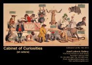
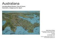
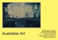
JOSEF LEBOVIC GALLERYEstablished 1977103a Anzac Parade, Kensington (Sydney) NSWPost: PO Box 93, Kensington NSW 2033, AustraliaTel: (02) 9663 4848 • Fax: (02) 9663 4447 • Intl: (+61-2)Email: josef@joseflebovicgallery.com • Web: joseflebovicgallery.comOpen: Wednesday to Friday 1-6pm, Saturday 12-5pm • ABN 15 800 737 094Member of • Association of International Photography Art Dealers Inc.International Fine Print Dealers Assoc. • Australian Art & Antique Dealers Assoc.2COLLECTORS’ LIST No. 147, 2011AustralasianaCompiled by <strong>Josef</strong> & Jeanne <strong>Lebovic</strong>, Lenka Miklos,Mariela Brozky, Takeaki TotsukaOn exhibition from Wed., 9 March to Sat., 9 April 2011, and on our websitefrom Saturday, 19 March.Prices are in Australian dollars and include GST.Exch. rates as at time of printing: AUD $1.00 = USD $1.00; UK £0.62p© Licence by VISCOPY AUSTRALIA 2011 LRN 5523Come see our new premisesWe are now open from Wednesday to Friday,1-6pm and Saturday, 12-5pm. Otherwise we areavailable by appointment. You are most welcometo phone if you need any directions to findus at the corner of Anzac Parade and Duke Street,Kensington. NB: We are only 10 minutes fromPaddington and down the road on the same sideas Peter’s of Kensington.1. The First Map Of Australia FromNicholas Vallard’s Atlas, 1547/1856.Colour lithograph, text in lower margin,37.7 x 55.6cm. Slight foxing, surfacesoiling. In rosewood frame. $6,600Text reads “McGahey, Chromo. Lith. Chester.”Accompanied with newspaper article entitled“Facsimile of the Dauphin Chart” from IllustratedSydney News, 1890.“Published by Middle Hill Press, Worcestershirein 1856, this is a copy of an original manuscriptmap of Java-Le-Grande, first producedin 1547. One of 15 maps of the known worldappearing in the Vallard Atlas, it is from the ‘Dieppe School’ of French cartography. This group of mapmakers ...borrowed heavily on the work of other European nations especially the Portuguese. North is tothe bottom. Some suggest that this landmass depicts the eastern coastline of Australia and was a resultof the explorations made by Cristóvão de Mendonça. In 1521, King John III sent him to claim new landsfor Portugal before Ferdinand Magellan could do the same for Spain. Hailed in 1856 as ‘The First Map ofAustralia’, it was seen as an affront to the achievements of Captain James Cook RN ...” Ref: Museum ofWestern Australia.3. [Transportation] R. Seymour. “The LookingGlass”, 1830. Hand-coloured lithograph with 12vignettes, publication name, artist, date and textthroughout image, 35.3 x 24.7cm. Repaired tears tomargins, slight stains and foxing overall. $1,950Text includes “None see themselves but by reflection – in thisglass you may. Vol. 1, No. 8, Aug. 1 st 1830.” One vignette depictsa winged demon in a boat, transporting a corpulent gentlemanimpaled on a staff and is captioned “For Van Demon’s Land direct.”2. [Transportation] Anon. A BondStreet Lounger Recently Detected,1802/1820s. Hand-coloured etching,cap tioned and num bered “277” with textin plate above and below image, 19.8 x24.4cm. Slight old mount burn. $1,650Caption continues “Sur you’ve stole my gown,here it is under your hat...” Text includes“Published Nov. 18, 1802, by Laurie & Whittle,53 Fleet St., London.” The picture in the backgroundiscaptioned “AView of PortJackson.”