Annual Report 2005 (62.7MB) - Western Riverside County Regional ...
Annual Report 2005 (62.7MB) - Western Riverside County Regional ...
Annual Report 2005 (62.7MB) - Western Riverside County Regional ...
- No tags were found...

You also want an ePaper? Increase the reach of your titles
YUMPU automatically turns print PDFs into web optimized ePapers that Google loves.
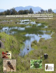
<strong>Western</strong> <strong>Riverside</strong> <strong>County</strong><strong>Regional</strong> Conservation AuthorityMULTIPLE SPECIES HABITAT CONSERVATION PLAN<strong>Annual</strong> <strong>Report</strong> <strong>2005</strong>
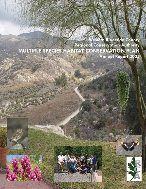
Cover DescriptionThe photo on the cover of the <strong>2005</strong> <strong>Annual</strong> <strong>Report</strong> is of the 909-acre Goodhart Wildlife Habitat Reserve that wasacquired in September <strong>2005</strong>. The property is located in Cactus Valley within Rough Step Unit 4. The view in thephoto is looking east toward the San Jacinto Mountains. A formal dedication of the reserve was held on November10, <strong>2005</strong>. Further details can be found on the internet at:http://www.wrc-rca.org/Acquisitions/NewsReleases_1110<strong>2005</strong>.htmlAlso on the cover is a picture of the burrowing owl (Athene cunicularia hypugea), the purple owl's clover (Castillejaexserta), and a butterfly represented by the California sister (Adelpha bredowii).The center picture is the staff from the <strong>2005</strong> Biological Monitoring Program (back row, left to right): AdamMalisch, Andrew Miller, Christine Rothenbach, Brian Root, Karin Cleary-Rose, Yvonne Moore, Debra De La Torre,Shirley Bartz, Maria Arellano, Annie Bustamante, Rosina Gallego, Michael Aspell, Jason Hlebakos. Front row, leftto right: Josh Koepke, Nicholas Vandeusen, Ricky Escobar.
<strong>Western</strong> <strong>Riverside</strong> <strong>County</strong>MULTIPLE SPECIES HABITATCONSERVATION PLANANNUAL REPORTFor the PeriodJanuary 1, <strong>2005</strong> through December 31, <strong>2005</strong>Submitted by the<strong>Western</strong> <strong>Riverside</strong> <strong>County</strong> <strong>Regional</strong> Conservation AuthorityOctober 2006
TABLE OF CONTENTSSectionPage No.EXECUTIVE SUMMARY ........................................................................................ ES-11.0 INTRODUCTION ...................................................................................................... 1-11.1 Overview of the Plan ........................................................................................... 1-11.2 <strong>Report</strong>ing Requirements ...................................................................................... 1-31.3 Methods................................................................................................................ 1-42.0 HABITAT GAINS AND LOSSES (Reserve Assembly Activities)............................ 2-12.1 Rough Step Acreage Summaries ......................................................................... 2-12.1.1 Rough Step 1............................................................................................ 2-32.1.2 Rough Step 2............................................................................................ 2-82.1.3 Rough Step 3.......................................................................................... 2-102.1.4 Rough Step 4.......................................................................................... 2-132.1.5 Rough Step 5.......................................................................................... 2-152.1.6 Rough Step 6.......................................................................................... 2-182.1.7 Rough Step 7.......................................................................................... 2-202.1.8 Rough Step 8.......................................................................................... 2-232.2 Conservation by Area Plan ................................................................................ 2-252.3 Conservation by Area Plan and Subunits........................................................... 2-272.4 Conservation by Jurisdiction.............................................................................. 2-323.0 ACTIVITIES WITHIN PLAN AREA......................................................................... 3-13.1 Grading/Building Permit Activity........................................................................ 3-13.2 Single Family/Mobile Home Activity ................................................................. 3-23.2.1 Background.............................................................................................. 3-23.2.2 Effect on Reserve Assembly.................................................................... 3-33.2.3 2006 Work Plan ....................................................................................... 3-33.3 Agricultural Lands ............................................................................................... 3-43.3.1 Background.............................................................................................. 3-43.3.2 Current Status........................................................................................... 3-53.3.3 Agricultural Grading Permits................................................................... 3-53.3.4 2006 Work Program................................................................................. 3-53.4 Public Works Projects.......................................................................................... 3-83.4.1 <strong>County</strong> of <strong>Riverside</strong> Transportation Department..................................... 3-93.4.2 <strong>Riverside</strong> <strong>County</strong> Parks and Open Space District.................................... 3-93.4.3 <strong>Riverside</strong> <strong>County</strong> Transportation Commission (RCTC).......................... 3-93.4.4 <strong>Riverside</strong> <strong>County</strong> Waste Management Department................................. 3-9<strong>Western</strong> <strong>Riverside</strong> <strong>County</strong> MSHCP October 2006<strong>Annual</strong> <strong>Report</strong> (January 1, <strong>2005</strong> through December 31, <strong>2005</strong>)ToC-i
TABLE OF CONTENTSSectionPage No.3.4.5 <strong>Riverside</strong> <strong>County</strong> Flood Control and Water Conservation District......... 3-93.4.6 California State Parks ............................................................................ 3-103.4.7 CalTrans................................................................................................. 3-103.4.8 City of Moreno Valley........................................................................... 3-103.5 Participating Special Entity Permits .................................................................. 3-103.6 Criteria Refinement............................................................................................ 3-113.7 Memoranda of Understanding ........................................................................... 3-113.8 Review of Public/Quasi-Public Lands............................................................... 3-123.9 Clerical/Minor Amendments to the MSHCP..................................................... 3-134.0 FUNDING SUMMARY................................................................................................. 4-15.0 MANAGEMENT ACTIVITIES................................................................................... 5-15.1 Management Goal................................................................................................ 5-15.2 General Management Activities .......................................................................... 5-15.3 RCA Property Management................................................................................. 5-15.4 RCA Properties Managed By the Park District ................................................... 5-25.5 Results .................................................................................................................. 5-25.5.1 Acquisitions ............................................................................................. 5-25.5.2 Habitat Protection .................................................................................... 5-45.5.3 Baseline Management Assessments ........................................................ 5-45.5.4 Monitoring Coordination ......................................................................... 5-45.6 Future Management Activities............................................................................. 5-56.0 MONITORING ACTIVITIES ..................................................................................... 6-16.1 Goals and Objectives ........................................................................................... 6-16.2 Inventory Phase.................................................................................................... 6-16.3 Monitoring Program Operations.......................................................................... 6-16.3.1 Monitoring Program Personnel................................................................ 6-26.3.2 Training.................................................................................................... 6-36.3.3 Land Access Agreements & Coordination with Reserve Managers........ 6-36.4 Summary of <strong>2005</strong> Monitoring Activities and Evaluation ofProgress toward Achieving Measurable Objectives ............................................ 6-56.4.1 Vegetation Mapping and Habitat Assessment ......................................... 6-66.4.2 Rare Plant Surveys................................................................................... 6-86.4.3 Quino Checkerspot Surveys..................................................................... 6-86.4.4 Delhi Sand Flower-Loving Fly (Delhi fly) Surveys .............................. 6-10<strong>Western</strong> <strong>Riverside</strong> <strong>County</strong> MSHCP October 2006<strong>Annual</strong> <strong>Report</strong> (January 1, <strong>2005</strong> through December 31, <strong>2005</strong>)ToC-ii
TABLE OF CONTENTSSectionPage No.6.4.5 Small Mammal Trapping ....................................................................... 6-106.4.6 Grasshopper Sparrow Surveys............................................................... 6-146.4.7 Tricolored Blackbird Surveys................................................................ 6-146.4.8 Amphibian Stream Surveys ................................................................... 6-166.4.9 Incidental Species Sightings .................................................................. 6-186.5 Suggested Changes/Feedback for Adaptive Management................................. 6-186.6 Species Objectives Monitored by the Biological Monitoring Program andCovered Species Survey Schedule..................................................................... 6-187.0 REFERENCES ...................................................................................................... 7-1LIST OF FIGURESFigure 1 <strong>Riverside</strong> <strong>County</strong> Location Map..........................................................................1-2Figure 2 <strong>Western</strong> <strong>Riverside</strong> <strong>County</strong> MSHCP Rough Step Analysis Units ........................2-2Figure 3 Rough Step Unit #1..............................................................................................2-5Figure 4 Rough Step Unit #2..............................................................................................2-9Figure 5 Rough Step Unit #3............................................................................................2-11Figure 6 Rough Step Unit #4............................................................................................2-14Figure 7 Rough Step Unit #5............................................................................................2-16Figure 8 Rough Step Unit #6............................................................................................2-19Figure 9 Rough Step Unit #7............................................................................................2-21Figure 10 Rough Step Unit #8............................................................................................ 2-24Figure 11 <strong>Western</strong> <strong>Riverside</strong> <strong>County</strong> MSHCP Area Plan Boundaries and SubUnits........2-26Figure 12 Expedited Review Process Activity (January 1 – December 31, <strong>2005</strong>) .............. 3-6Figure 13 Existing Agricultural Lands <strong>Western</strong> <strong>Riverside</strong> <strong>County</strong> ..................................... 3-7Figure 14 Potential Access Areas for Monitoring Activities ............................................... 6-4Figure 15 Rare Plant Surveys <strong>2005</strong>...................................................................................... 6-9Figure 16 Quino Checkerspot and Delhi Fly Surveys <strong>2005</strong>............................................... 6-11Figure 17 Small Mammal Trapping ................................................................................... 6-13Figure 18 Grasshopper Sparrow and Tricolored Blackbird ............................................... 6-15Figure 19 Amphibian Stream Survey Locations and Detections in <strong>2005</strong> .......................... 6-17<strong>Western</strong> <strong>Riverside</strong> <strong>County</strong> MSHCP October 2006<strong>Annual</strong> <strong>Report</strong> (January 1, <strong>2005</strong> through December 31, <strong>2005</strong>)ToC-iii
TABLE OF CONTENTSSectionPage No.LIST OF TABLESTable 1 Rough Step Acreage Summary............................................................................ 2-4Table 2 Rough Step 1 Acreage Totals .............................................................................. 2-6Table 2b Delhi Soils Rough Step Acreage Analysis........................................................... 2-7Table 3 Rough Step 2 Acreage Totals .............................................................................. 2-8Table 4 Rough Step 3 Acreage Totals ............................................................................ 2-12Table 5 Rough Step 4 Acreage Totals ............................................................................ 2-13Table 6 Rough Step 5 Acreage Totals ............................................................................ 2-17Table 7 Rough Step 6 Acreage Totals ............................................................................ 2-18Table 8 Rough Step 7 Acreage Totals ............................................................................ 2-22Table 9 Rough Step 8 Acreage Totals ............................................................................ 2-23Table 10 Conservation By Area Plan................................................................................ 2-27Table 11 Target Acreage Summary – By Area Plan And Subunit .................................. 2-28Table 12 Conservation by Jurisdiction.............................................................................. 2-33Table 13 Grading/Building Permits By Member Agency Issued ....................................... 3-1Table 14 Agricultural Grading Permits Issued Between January 1And December 31, <strong>2005</strong> ...................................................................................... 3-7Table 15 Public Works Projects January 1 And December 31, <strong>2005</strong>................................. 3-8Table 16 Financial Information For RCA Program Operation........................................... 4-1Table 17 Permittee Revenue (January 1 - December 31, <strong>2005</strong>) ......................................... 4-3Table 18 MSHCP Sites Currently Managed by <strong>Riverside</strong> <strong>County</strong> Parks District.............. 5-6Table 19 Monitoring Program Personnel............................................................................ 6-2Table 20 Access Agreements Obtained For Surveys In <strong>2005</strong> ............................................ 6-5Table 21 Floristic Comparison between the 1995 MSHCP Vegetation Map HabitatClassifications and the <strong>2005</strong> Vegetation Map Classifications............................. 6-7Table 22 Covered Species Monitoring Program Details .................................................. 6-19<strong>Western</strong> <strong>Riverside</strong> <strong>County</strong> MSHCP October 2006<strong>Annual</strong> <strong>Report</strong> (January 1, <strong>2005</strong> through December 31, <strong>2005</strong>)ToC-iv
EXECUTIVE SUMMARYEXECUTIVE SUMMARYThe <strong>Western</strong> <strong>Riverside</strong> <strong>County</strong> Multiple Species Habitat Conservation Plan (MSHCP) is acomprehensive, multi-jurisdictional plan that conserves species and associated habitats toaddress biological and ecological diversity conservation needs in western <strong>Riverside</strong> <strong>County</strong>.The plan was approved and permits issued on June 22, 2004, by the U.S. Fish and WildlifeService (USFWS) and California Department of Fish and Game (CDFG). The MSHCP PlanningArea encompasses approximately 1.26 million acres in western <strong>Riverside</strong> <strong>County</strong>. The MSHCPcalls for the conservation and management of approximately 500,000 acres of the 1.26-millionacrePlan Area. Of the 500,000 acres, 347,000 acres are currently within existing public/quasipublicownership. Achievement of the 500,000-acre goal depends on conservation of anadditional 153,000 acres within the Plan Area.The <strong>Western</strong> <strong>Riverside</strong> <strong>County</strong> <strong>Regional</strong> Conservation Authority (RCA) was formed in February2004 and assumed administration and implementation responsibility for the MSHCP in March2004. The MSHCP requires that the RCA prepare and submit a report of its annual activities.This report provides a summary of activities for the reporting period of January 1, <strong>2005</strong>, throughDecember 31, <strong>2005</strong>. This report is the first MSHCP annual report that covers a full calendaryear.<strong>Report</strong>ing RequirementsIn addition to reporting the amount of habitat conserved and developed during the reportingperiod, this report includes other information that measures MSHCP progress. At a minimum,the annual report includes:• Reserve Assembly activities in relation to the rough step formulas presented in Section6.7 of the MSHCP and in accordance with species-specific Objective 1B of the DelhiSands flower-loving fly.• Acres authorized for disturbance within the Plan Area during the reporting period.• Single-family and mobile home activity within the Criteria Area for the preceding yearand cumulatively occurring under the expedited review process for these activitiespresented in Section 6.1.1 of the MSHCP.• New or expanded agricultural operations within the Criteria Area for the preceding yearand cumulatively occurring under the processes identified in Section 6.2 of the MSHCP.• Minor Administrative/Clerical Amendments approved during the reporting period inaccordance with the procedures described in Section 6.10.2 of the MSHCP.<strong>Western</strong> <strong>Riverside</strong> <strong>County</strong> MSHCP October 2006<strong>Annual</strong> <strong>Report</strong> (January 1, <strong>2005</strong> through December 31, <strong>2005</strong>)ES-1
EXECUTIVE SUMMARY• Ongoing management and monitoring activities highlighting issues of concern andproposed remedies/actions.• Documentation concerning funding/collection of mitigation fees.Major Activities in <strong>2005</strong>During <strong>2005</strong>, the RCA executive director and staff focused on (1) further developing theorganizational structure to implement the Plan, including adding two additional full-time <strong>County</strong>Contracted Staff for geographic information system (GIS) and Information Technology duringMarch and April <strong>2005</strong>; (2) providing on-site enhanced training sessions to the local Permitteesregarding Plan implementation, including assistance in developing a Habitat AcquisitionNegotiation Strategy (HANS) or similar process; (3) fully implementing Joint Project Review(JPR) for projects within the Criteria Area and establishing the supporting GIS data sets; (4)holding regular meetings of the RCA Board and Administrative Committee meetings; (5)revising and implementing new fee collection procedures for implementation in 2006; (6)preparing and distributing the initial annual report for 2004 covering the period of June 22, 2004,through December 31, 2004; (7) continuing the process of acquiring additional Reserve lands;(8) implementing the first full year of the Monitoring Program; and (9) implementingorganizational and financial audit procedures and finalizing contracts for services and otherfunctions. Additionally, the RCA Board hired Tom Mullen to serve as the RCA InterimExecutive Director and hired Joe Richards to serve as the Deputy Director.Two committees, the Reserve Management Oversight Committee and the Funding CoordinationCommittee, were established by the RCA Executive Director to provide expertise and leadershipfor MSHCP implementation. During <strong>2005</strong>, each committee met twice: the Reserve ManagementOversight Committee met March 28 and June 14, <strong>2005</strong>, and the Funding CoordinationCommittee met February 24 and May 19, <strong>2005</strong>.In May <strong>2005</strong>, the RCA released the <strong>Western</strong> <strong>Riverside</strong> <strong>County</strong> RCA website (www.wrc-rca.org).The RCA website was developed to provide the public with access to valuable information, suchas the Plan and Implementing Agreement text, RCA functions, links to other relevant websites,background information on the MSHCP and the RCA, current and upcoming events, such asrecent acquisitions, and RCA Board and committee meeting dates, locations, agendas, andminutes. RCA staff continues to update and improve the RCA website. In December <strong>2005</strong>, thewebsite was enhanced to improve the user interface and include additional information.In <strong>2005</strong>, the RCA and the <strong>Riverside</strong> <strong>County</strong> Transportation Commission (RCTC) jointlypurchased 909 acres in Cactus Valley owned by the Goodhart family. The property, locatedapproximately 5 miles southeast of Diamond Valley Lake, was acquired for $5.1 million. The<strong>Western</strong> <strong>Riverside</strong> <strong>County</strong> MSHCP October 2006<strong>Annual</strong> <strong>Report</strong> (January 1, <strong>2005</strong> through December 31, <strong>2005</strong>)ES-2
EXECUTIVE SUMMARYGoodhart property is home to over 75 plants and animal species and provides an importantlinkage for species that travel between Wilson Valley and the San Bernardino National Forest.Other noteworthy <strong>2005</strong> acquisitions were the <strong>Riverside</strong> Clark property (724 acres), the CuchiaVogal property (666 acres), the Long Beach Equities property (300 acres), and 711 acres fromCalifornia State University.Reserve Assembly ActivitiesThe MSHCP is a criteria-based plan that contains three main performance measures. Theseperformance measures were intended to ensure that conservation was occurring simultaneouswith development. Each of the following performance measures is equally important inmeasuring Plan implementation progress:• Rough step area and habitat type• Area Plan and subunit• Jurisdictional boundaries (Cities and <strong>Riverside</strong> <strong>County</strong>).RCA staff worked with each city and the <strong>County</strong> to build a GIS database of relevantconservation and development activity, which was used to calculate progress under theperformance measures. For annual reporting purposes, conservation is generally counted as a“gain” when acquired through transfer of title or recordation of conservation easement. Thisannual report reflects acres conserved between February 2000 and December 31, <strong>2005</strong>.Development “losses” are counted at the time of grading permit issuance. This annual reportreflects losses between MSHCP initiation on June 22, 2004, and the end of this annual report’sreporting period on December 31, <strong>2005</strong>. The acres conserved are counted prior to MSHCPissuance because the <strong>County</strong>, CDFG, California Department of Parks and Recreation, and theUSFWS, in anticipation of MSHCP permit issuance, began an early, aggressive campaign toassemble the Reserve prior to Plan permit issuance. Since the Plan’s state and federal permitswere not issued until June 22, 2004, habitat losses are only tracked starting from June 22, 2004.Rough Step Acreage SummariesAs stated above, performance measures, including the “rough step,” are used to monitor generalsuccess of the Plan. The rough step measure is a tool to help direct conservation withinvegetation communities of similar weather patterns, geographies, soils, and geologies asdevelopment occurs. The rough step measure is intended to ensure that conservation of specificnarrowly distributed habitats occur in rough step with development. The rough step analysis<strong>Western</strong> <strong>Riverside</strong> <strong>County</strong> MSHCP October 2006<strong>Annual</strong> <strong>Report</strong> (January 1, <strong>2005</strong> through December 31, <strong>2005</strong>)ES-3
EXECUTIVE SUMMARYfunctions as an early warning system to signal where development is outpacing conservation, andwhere conservation efforts therefore need to be focused.Development is outpacing conservation in many of the vegetation communities where the roughstep formula applies (see Section 2). That is, the number of acres authorized for disturbance inthe vegetation communities is higher than the allowable number of development acres calculatedusing the rough step formula. Some of the vegetation communities in Rough Step Units 6 and 8are close to being within rough step. For example, in Rough Step Unit 6, 172 acres of coastalsage scrub have been developed; since the allowable loss of coastal sage scrub is approximately156 acres this vegetation community within Rough Step Unit 6 is out of rough step. However, inthe grassland vegetation community within Rough Step Unit 6, conservation is in rough stepwith development: 370 acres of grassland were impacted; allowable loss was 444 acres. Of the37 rough step vegetation communities within the Plan area, 19 are in rough step, and 18 are outof rough step. Of the 18 that are out of rough step, 6 are out by more than 50 acres (3 coastalsage scrub, and 3 grassland), 6 are out by between 50 and 10 acres, and 6 are out by 10 acres orless. The <strong>2005</strong> rough step analysis indicates that efforts need to be focused toward conserving thefollowing vegetation communities within specific rough step units:Rough Step Unit 1:Grasslands<strong>Riverside</strong>an Scrub, Woodland, ForestRough Step Unit 3:Coastal Sage ScrubGrasslands<strong>Riverside</strong>an Alluvial Fan Sage ScrubRough Step Unit 4:Coastal Sage ScrubDesert ScrubsGrasslandsRough Step Unit 5:Coastal Sage ScrubGrasslandsRiparian Scrub, Woodland, Forest<strong>Riverside</strong>an Alluvial Fan Sage ScrubWoodlands and Forests<strong>Western</strong> <strong>Riverside</strong> <strong>County</strong> MSHCP October 2006<strong>Annual</strong> <strong>Report</strong> (January 1, <strong>2005</strong> through December 31, <strong>2005</strong>)ES-4
EXECUTIVE SUMMARYRough Step Unit 6:Coastal Sage ScrubRiparian Scrub, Woodland, ForestRough Step Unit 7:<strong>Riverside</strong>an Alluvial Fan Sage ScrubRough Step Unit 8:Grasslands<strong>Riverside</strong>an Alluvial Fan Sage ScrubSeveral key acquisitions have occurred in 2006 and will be reflected in the 2006 <strong>Annual</strong> <strong>Report</strong>.Because the rough step analysis is an acquisition planning tool, the RCA felt it pertinent toinclude reference to several key acquisitions that had occurred by the fall of 2006 within specificrough step categories. This acquisition information provides the reader with a snapshot of the“gains” that are likely to be reported in the 2006 annual report and positively impact the roughstep calculations in several key areas. By the fall of 2006, an additional 5,000 acres have beenacquired, and an additional 5,000 acres are pending acquisition.Conservation by Area PlanThe MSHCP divides western <strong>Riverside</strong> <strong>County</strong> into “Area Plans” for management purposes.Area Plans are synonymous with the Area Plans delineated in the <strong>Riverside</strong> <strong>County</strong> GeneralPlan. RCA staff calculated and summarized all lands conserved by Area Plan. This allows thePermittees to determine where the most conservation has occurred, assess target conservationgoals, and prioritize areas where future conservation should occur. The <strong>2005</strong> annual reportanalysis shows that The Pass Area Plan is closest to its target acquisition range of 8,540 to13,925 acres, due largely to the Potrero Canyon acquisition, which has resulted in 8,935 acres ofconservation in this Area Plan. No other Area Plans have achieved their target conservationacreage range.Conservation by Area Plan SubunitThe MSHCP identifies target acreages by Area Plan and subunit and designates a low, mid, andhigh range or acreage for each subunit. This allows the RCA to calculate a running total of allland conserved within the MSHCP area and allows a more detailed accounting of these totals.This analysis will help conservation efforts and could direct management and monitoring effortsto more specific areas, if necessary. Acreage goals for Subunit 1, Potrero/Badlands, in the Pass<strong>Western</strong> <strong>Riverside</strong> <strong>County</strong> MSHCP October 2006<strong>Annual</strong> <strong>Report</strong> (January 1, <strong>2005</strong> through December 31, <strong>2005</strong>)ES-5
EXECUTIVE SUMMARYArea Plan, have been achieved. This subunit has an acreage conservation goal of 5,570 to 9,275acres; 5,622 acres have been conserved, largely due to the Potrero Canyon acquisition.Conservation by City and <strong>County</strong> JurisdictionThe MSHCP also identifies conservation acreage targets by City and <strong>County</strong> jurisdictions. RCAstaff used acquisition data to calculate the acreage of lands conserved within each jurisdictionand compared these acreages to each target. To date, the conservation acreage goal has beensatisfied in the City of Moreno Valley. In addition, progress toward acreage goals has beenmade in Beaumont, Murrieta, Lake Elsinore, and Calimesa. No conservation gains wererecorded during the reporting period for Banning, Canyon Lake, Corona, Hemet, Norco, Perris,<strong>Riverside</strong>, San Jacinto, or Temecula, although as of the fall of 2006, several acquisitions are inprogress in these jurisdictions.Reserve ManagementThe RCA has contracted with the <strong>Riverside</strong> <strong>County</strong> <strong>Regional</strong> Parks and Open Space District(District) to manage most of the RCA properties. The District employs two full-time employeesand one half-time employee for the sole purpose of MSHCP Reserve management. The Districtcurrently manages 26 properties for the MSHCP, totaling approximately 6,246 acres. Other landmanagement agencies/entities managing public land within the MSHCP Conservation Areainclude the U.S. Forest Service, the U.S. Bureau of Land Management, the Center for NaturalLands Management, the University of California, <strong>Riverside</strong>, the CDFG, and the CaliforniaDepartment of Parks and Recreation. The District coordinates with these agencies/entities onbehalf of the RCA to ensure consistent management throughout the MSHCP Conservation Area.Due to the interim nature of the RCA/District contract, management was carried out in a minimalfashion. Staff during the <strong>2005</strong> year included a Natural Resources Manager (three-quarter time),one Park Ranger, and one Park Maintenance Worker.Monitoring ProgramThe MSHCP and its associated Implementing Agreement designates CDFG to serve as theMonitoring Program Coordinator for the first 8 years of MSHCP implementation. The programis divided into two phases. The first phase focuses on mapping vegetation communities,gathering existing species information, conducting field surveys for selected species, and testinga community-based approach. The second, long-term monitoring phase will utilize a multiplespecies sampling strategy (i.e., sampling design, sampling locations, and survey protocols) thatwill be developed based on the information gathered during the initial phase.<strong>Western</strong> <strong>Riverside</strong> <strong>County</strong> MSHCP October 2006<strong>Annual</strong> <strong>Report</strong> (January 1, <strong>2005</strong> through December 31, <strong>2005</strong>)ES-6
EXECUTIVE SUMMARYThe monitoring program is in its initial stage. CDFG, working with others, has surveyed severalspecies, including the mountain yellow-legged frog, arroyo toad, California red-legged frog, andburrowing owl. CDFG has also surveyed selected reptile, raptor, and plant species and severalvegetation communities. Since the monitoring program is in its incipient stages of datacollection, data analyses or suggested changes for adaptive management are not included in thisannual report; however, they will be in future reports as applicable.SummaryThis report provides a means of evaluating the effectiveness of MSHCP implementation and thesuccess of the RCA during its initial years of operation. It also provides a way to measurechanges on the landscape, assess rates of urban growth and habitats lost, direct futuredevelopment, and prioritize future acquisition and conservation efforts. Additionally, this reportlays the foundation for future reporting. As the RCA matures as an agency, each product andmilestone provides learning opportunities. During the preparation of this annual report, severallessons were learned and needs identified:• The need for uniform record keeping of development activity by local Permittees(including conservation areas obtained through the land development approval process)• The timely reporting of development activity by local Permittees• The need for assistance to local Permittees in their efforts to record development activityfor purposes of the annual report• The need for modifications to annual reporting requirements.In the coming year, RCA staff will continue to prepare materials and work with its memberagencies to assist in all aspects of Plan implementation. RCA staff also anticipates thatsubsequent annual reports will be based on more reliable data as the agency matures, operationsstabilize, and data standards are developed for all Permittees.<strong>Annual</strong> reports are a valuable planning tool for the RCA. The RCA is using this annual report’sfinding that many reporting areas appear to be out of rough step, with losses exceeding gains forthe reporting period, to shift 2006 acquisition and conservation efforts to achieve rough stepequilibrium.<strong>Western</strong> <strong>Riverside</strong> <strong>County</strong> MSHCP October 2006<strong>Annual</strong> <strong>Report</strong> (January 1, <strong>2005</strong> through December 31, <strong>2005</strong>)ES-7
1.0 INTRODUCTION1.0 INTRODUCTION1.1 Overview of the PlanThe <strong>Western</strong> <strong>Riverside</strong> <strong>County</strong> MSHCP is a comprehensive, multi-jurisdictional plan thatconserves species and associated habitats to address biological and ecological diversityconservation needs, while development is simultaneously approved in western <strong>Riverside</strong> <strong>County</strong>.The plan was approved and permits issued on June 22, 2004, by the USFWS and CDFG. TheMSHCP Plan Area encompasses approximately 1.26 million acres (approximately 1,966.7square miles) in western <strong>Riverside</strong> <strong>County</strong> (see Figure 1, <strong>Riverside</strong> <strong>County</strong> Location Map). Thisplan includes all land west of the crest of the San Jacinto Mountains and east of theOrange/<strong>Riverside</strong> <strong>County</strong> lines. The northern border of the Plan Area consists of the<strong>Riverside</strong>/San Bernardino <strong>County</strong> line, and the southern border consists of the <strong>Riverside</strong>/SanDiego <strong>County</strong> line. The Plan Area includes all unincorporated <strong>County</strong> of <strong>Riverside</strong> land withinthis geographic area, as well as the incorporated cities of Temecula, Murrieta, Lake Elsinore,Canyon Lake, Norco, Corona, <strong>Riverside</strong>, Moreno Valley, Banning, Beaumont, Calimesa, Perris,Hemet, and San Jacinto. The Plan is the largest HCP ever attempted and covers multiple speciesand multiple habitats within a diverse landscape from urban cities to undeveloped foothills andmontane forests. Bioregions within the Plan Area include the Santa Ana Mountains, <strong>Riverside</strong>Lowlands, San Jacinto Foothills, San Jacinto Mountains, Agua Tibia Mountains, DesertTransition, and San Bernardino Mountains.The MSHCP calls for the conservation and management of approximately 500,000 acres of the1.26-million-acre Plan Area. Of the 500,000 acres, 347,000 acres are currently within existingpublic/quasi-public ownership. Achievement of the 500,000-acre goal depends on conservationof an additional 153,000 acres within the Plan Area. This plan was developed in conjunctionwith the CDFG, USFWS, multiple local jurisdictions, state, federal, and local agencies, andpublic interest groups/stakeholders.The <strong>Western</strong> <strong>Riverside</strong> <strong>County</strong> RCA was formed in January 2004 and assumed administrationand implementation responsibility for the MSHCP in March 2004. The RCA is a Joint PowersAuthority, which is responsible for acquiring additional conservation acres necessary for meetingPlan goals, managing and monitoring the 153,000-acre MSHCP Conservation Area, overseeingPlan compliance, and assisting with MSHCP implementation across the Plan Area.<strong>Western</strong> <strong>Riverside</strong> <strong>County</strong> MSHCP October 2006<strong>Annual</strong> <strong>Report</strong> (January 1, <strong>2005</strong> through December 31, <strong>2005</strong>) 1-1
OregonIdaho<strong>Riverside</strong> <strong>County</strong> Location MapNevadaCaliforniaPacific OceanArizona<strong>Riverside</strong> <strong>County</strong>¯FIGUREBaja California1
1.0 INTRODUCTION1.2 <strong>Report</strong>ing RequirementsThe MSHCP requires that the RCA prepare and submit a report of its annual activities. Thisreport provides a summary of MSHCP implementation activities for the first full year ofRCA operation: January 1, <strong>2005</strong>, through December 31, <strong>2005</strong>. In early <strong>2005</strong>, the ReserveManagement Oversight Committee opted to prepare an annual report reflecting the first year ofofficial MSHCP implementation (June 22, 2004, to December 31, 2004). This first officialMSHCP annual report only reflected activity in the latter half of 2004. For this reason, the <strong>2005</strong>annual report reflects the first full year of formal MSHCP implementation activities. Largelydue to annual biological resource seasonality considerations, all subsequent annual reports willoccur on a calendar year basis.Per the MSHCP, the annual report must include a description of:• Reserve Assembly activities in relation to the rough step formulas presented in Section6.7 of the MSHCP and in accordance with species-specific Objective 1B for the DelhiSands flower-loving fly. The rough step is a tool to help direct conservation withinvegetation communities of similar weather patterns, geographies, soils, and geologies asdevelopment occurs. It is intended to identify where development is proceeding at a pacethat would preclude achieving the conservation goals for specific key vegetationcommunities.• Acres authorized for disturbance within the Plan Area during the reporting period. Therough step, Area Plan, subunit, and jurisdictional performance measures use the totalacreage authorized for development in each reporting year. The number of acresauthorized for disturbance allows the RCA and Permittees to determine the rate ofdevelopment occurring in distinct geographic areas.• Single-family and mobile home activity within the Criteria Area for the preceding yearand cumulatively occurring under the expedited review process (ERP) for these activitiespresented in Section 6.1.1 of the MSHCP. Applications for a single-family home gradingpermit or for a mobile home site preparation permit within the Criteria Area are subject toreview against the MSHCP conservation criteria to determine the least sensitive locationfor building pad and necessary access roadways. This review process is referred to as theERP, and, with approval under this process, applicable properties are referred to as“ERPs.” The MSHCP included ERP activity assumptions (i.e., number of permits andacres disturbed (Section 7.3.2)). The annual reporting process is used to determinewhether ERP activity is occurring in a manner that is consistent with the assumptionsmade during MSHCP development. Furthermore, an analysis of ERP activity allows the<strong>Western</strong> <strong>Riverside</strong> <strong>County</strong> MSHCP October 2006<strong>Annual</strong> <strong>Report</strong> (January 1, <strong>2005</strong> through December 31, <strong>2005</strong>) 1-3
1.0 INTRODUCTIONRCA to determine if Reserve Assembly within the Criteria Area is being adverselyimpacted.• New or expanded agricultural operations within the Criteria Area for the preceding yearand cumulatively occurring under the processes identified in Section 6.2 of the MSHCP.Existing agricultural uses and conversion of natural lands to agricultural use are allowedas Covered Activities within the Criteria Area. New conversions to agricultural usewithin the Criteria Area are covered up to an established threshold of 10,000 acres overthe life of the Plan. The annual reporting process is used to establish this initialthreshold, to periodically measure new agricultural activities against it, and to analyzepotential impacts to Reserve Assembly associated with these new agricultural activities.• Minor Administrative/Clerical Amendments approved for the preceding year inaccordance with the procedures described in Section 6.10.2 of the MSHCP. The annualreport provides a method to officially document such amendments.• Ongoing management and monitoring activities highlighting issues of concern andproposed remedies/actions. These items are included in the annual report to give insightinto these efforts.• Documentation concerning funding/collection of the Local Development Mitigation Feesto provide insight into management of partial local funding resources available.1.3 MethodsRCA staff worked with each city and the <strong>County</strong> to build a GIS database of relevantconservation and development activity, which was used to calculate performance measures. Forannual reporting purposes, conservation is counted as a gain when acquired through transfer oftitle or recordation of conservation easement. This annual report reflects conservation betweenFebruary 2000 and December 31, <strong>2005</strong>. Development losses are counted at the time of gradingpermit issuance. This annual report reflects losses between June 22, 2004, and December 31,<strong>2005</strong>. Because losses are counted earlier in the development process (at time of grading permitissuance), and gains are counted at the end of the development process (at time of fee titletransfer/conservation easement recordation at the <strong>County</strong> Recorder’s Office), a disproportionateamount of habitat losses will always be reported before associated habitat gains can be reportedto offset those losses. In order to accommodate this lag, the MSHCP allowed gains to becounted from February 2000 rather than at the time of permit issuance (June 22, 2004). Thisreporting method eliminates the lag factor outlined above.<strong>Western</strong> <strong>Riverside</strong> <strong>County</strong> MSHCP October 2006<strong>Annual</strong> <strong>Report</strong> (January 1, <strong>2005</strong> through December 31, <strong>2005</strong>) 1-4
1.0 INTRODUCTIONCollection of annual loss data has been challenging. The Cities and the <strong>County</strong> maintain uniquepermit reporting systems, use of GIS as a land management tool varies widely acrossjurisdictions, and availability of staff to assist with data collection is limited. Several citiessubmitted hundreds of pages of permit issuance activity in place of mapped loss data. In order tocreate a comprehensive GIS loss database, RCA staff reviewed all data submitted by eachPermittee, including permit issuance data, and, in cases where building permits (i.e., post-gradingpermit stage) were recorded for areas that appeared to be undeveloped, the RCA assumed theland should be added to the loss database.Details regarding the methods used in preparing this report are included in Appendix A.<strong>Western</strong> <strong>Riverside</strong> <strong>County</strong> MSHCP October 2006<strong>Annual</strong> <strong>Report</strong> (January 1, <strong>2005</strong> through December 31, <strong>2005</strong>) 1-5
2.0 HABITAT GAINS AND LOSSES2.0 HABITAT GAINS AND LOSSES (RESERVE ASSEMBLYACTIVITIES)The MSHCP, and coverage for the 146 species identified in the Plan, are based on theestablishment of a 500,000-acre Conservation Area, of which approximately 347,000 acres arecurrently in public or quasi-public ownership. The additional 153,000 acres of additionalReserve lands will be assembled from private land acquisitions, donations, and through the landdevelopment entitlement process. As of December 31, <strong>2005</strong>, approximately 23,382 acres ofadditional Reserve lands had been acquired by local Permittees and state and federal agencies.As the Reserve is assembled, habitat is also lost to development, construction of infrastructure,and other activities. Habitat gains are the additional Reserve lands acquired or otherwisepermanently protected for conservation pursuant to the Plan. Habitat gained (or conserved) isreported from the period February 2000 through December 31, <strong>2005</strong>, because the <strong>County</strong>,CDFG, California Department of Parks and Recreation, and the USFWS, in anticipation ofMSHCP permit issuance, began an early, aggressive campaign to assemble the Reserve prior toPlan permit issuance. Since the Plan’s state and federal permits were not issued until June 22,2004, habitat losses are only tracked starting from June 22, 2004.The MSHCP is a criteria-based plan that has three main performance measures. Theseperformance measures were intended to ensure that conservation was occurring simultaneouswith development. Each of these performance measures is equally important in the Plan. Thissection reviews the progress, as of December 31, <strong>2005</strong>, toward meeting the followingperformance measures:• Rough step within key vegetation communities• Area Plan and subunit• Jurisdiction (Cities and <strong>Riverside</strong> <strong>County</strong>).2.1 Rough Step Acreage SummariesThe rough step measure is one of the MSHCP performance measures used to monitor success ofthe Plan. Rough step is a tool to help direct conservation within vegetation communities ofsimilar weather patterns, geographies, soils, and geologies as development occurs. The roughstep measure is intended to ensure that conservation of specific narrowly distributed habitatsoccurs in rough step with development. The rough step analysis functions as an early warningsystem to signal where development is outpacing conservation and where conservation effortstherefore need to be focused (see Figure 2, <strong>Western</strong> <strong>Riverside</strong> <strong>County</strong> MSHCP Rough StepAnalysis Units).<strong>Western</strong> <strong>Riverside</strong> <strong>County</strong> MSHCP October 2006<strong>Annual</strong> <strong>Report</strong> (January 1, <strong>2005</strong> through December 31, <strong>2005</strong>) 2-1
<strong>Western</strong> <strong>Riverside</strong> <strong>County</strong> MSHCP Rough Step Analysis UnitsSH-71M£Orange <strong>County</strong>ARCHIBALD AVEHAMNER AVE!"a#NORCOM»CORONARough Step Analysis UnitsMSHCP BoundaryCriteria AreaLIMONITE AVECAJALCO RDPublic/Quasi-Public Conserved LandsCitiesWater BodiesMajor RoadsHighwaysMqMISSION BLV!"a#1RIVERSIDETEMESCAL CANYON RD97CENTER ST8WOOD RDM¦!"a#5MqCANYONLAKE LAKEELSINOREGRAND AVEPALOMAR STPIGEON PASS RDCACTUS AVEMORENO VALLEYOLEANDER AVEELLIS AVE7
2.0 HABITAT GAINS AND LOSSESThe rough step analysis was conducted utilizing the rough step formula in Section 6.7 of theMSHCP. Table 1, Rough Step Acreage Summary, compares the acres by vegetation type withineach rough step’s Criteria Area of available private lands (column 3) and additional Reserve landgoals (column 4) to acres conserved (column 5) and acres developed (column 7). The sixthcolumn includes the allowable development acreage targets by vegetation type for each roughstep, based on the amount of conservation that has occurred (column 5). For purposes of thisreport, RCA staff used conservation acreages (column 5) achieved by December 31, <strong>2005</strong>, withineach rough step unit’s vegetation communities to ensure that development rates were notoutpacing conservation efforts within each vegetation community. Development rates werecalculated using allowable losses (derived from grading or building permits) between MSHCPimplementation on June 22, 2004, and the reporting period end on December 31, <strong>2005</strong>. Whereacres authorized for development (column 7) are higher than the allowable developmentcalculated using the rough step formula (column 6), the vegetation community would beconsidered out of rough step.Rough step calculations are limited to the MSHCP Criteria Area. Acquisitions that haveoccurred outside of the Criteria Cells will count toward the overall MSHCP conservation goal of153,000 acres; however, they are not factored into the rough step formulas. Because acresacquired outside of the Criteria Cells are not considered in the rough step analysis, the rough stepacreage total in this section will not match the total acres acquired through the end of <strong>2005</strong> aslisted in Sections 2.2, 2.3, and 2.4.Additional acres were conserved within the boundaries of the rough step units that were notwithin key vegetation communities. These additionally conserved acres are not counted asconservation towards key vegetation communities with the rough step. These acres wereconserved for a variety of different reasons, such as meeting the MSHCP subunit and Area Plangoals or acquiring a vital property that included and/or linked key vegetation communities. Toaccurately report conservation in the Criteria Area, the analyses by individual rough step units inthis section include acres acquired within all vegetation communities within the Criteria Area ofeach rough step, including those vegetation communities where rough step goals do not exist.Acres acquired outside of the Criteria Area are not reflected in the following rough step tables.2.1.1 Rough Step 1Rough Step 1 encompasses 94,000 acres within the northwestern corner of western <strong>Riverside</strong><strong>County</strong> and includes the Prado Basin, Santa Ana River, Delhi Sands flower-loving fly habitat,and the Jurupa Mountains (see Figure 3, Rough Step Unit #1). It is bounded by Interstate 91 tothe southeast, Cleveland National Forest to the southwest, and Orange and San BernardinoCounties to the north and west. Within Rough Step 1, there are approximately 10,000 acres<strong>Western</strong> <strong>Riverside</strong> <strong>County</strong> MSHCP October 2006<strong>Annual</strong> <strong>Report</strong> (January 1, <strong>2005</strong> through December 31, <strong>2005</strong>) 2-3
2.0 HABITAT GAINS AND LOSSESRoughStepAnalysisUnit1TABLE 1Rough Step Acreage SummaryFrom Table 6-3 in MSHCPPrivateAllowableLandDevelopment Total AcresAcres Additional Total Acres Acreage Authorized forwithin the Reserve Conserved through Development byCriteria Land (between December 31, Cities and theArea in Acreage Goal February <strong>2005</strong> (Utilizing <strong>County</strong> (betweenthe for the Key 2000 and Rough Step June 22, 2004,Key Vegetation Communities Analysis Vegetation December Forecasting and December 31,within Analysis UnitUnit Community 31, <strong>2005</strong>) Formula)<strong>2005</strong>)Coastal Sage Scrub 1,080 800 167 58 42Grasslands 820 180 0 0 20Riparian Scrub, Woodland, Forest 680 550 0 0 42 δ Coastal Sage Scrub 14,950 10,340 2,174 969 77Grasslands 8,570 4,780 822 652 111Riparian Scrub, Woodland, Forest 590 460 137 39 3<strong>Riverside</strong>an Alluvial Fan Sage Scrub 1,190 1,110 159 11 1Woodlands and Forests 290 170 12 9 0345678Coastal Sage Scrub 3,670 2,050 0 0 56Grasslands 4,690 900 39 164 204Playas and Vernal Pools 4,340 3,830 608 81 0Riparian Scrub, Woodland, Forest 220 110 3 3 0<strong>Riverside</strong>an Alluvial Fan Sage Scrub 190 100 0 0 2Coastal Sage Scrub 21,340 17,460 795 177 415Desert Scrubs 4,340 3,680 66 12 44Grasslands 10,990 5,960 143 121 350Riparian Scrub, Woodland and1,420 1,320 0 0 0Forest<strong>Riverside</strong>an Alluvial Fan Sage Scrub 1,160 1,090 40 3 2Woodlands and Forests 1,560 870 52 41 24Coastal Sage Scrub 1,540 370 4 12 104Grasslands 3,880 1,010 11 31 295Riparian Scrub, Woodland, Forest 550 460 0 0 20<strong>Riverside</strong>an Alluvial Fan Sage Scrub 370 260 0 0 14Woodlands and Forests 2,080 1,000 0 0 72Coastal Sage Scrub 4,980 4,060 687 156 172Grasslands 6,190 3,690 656 444 370Riparian Scrub, Woodland, Forest 270 210 6 2 12Woodlands and Forests 140 110 24 7 5Coastal Sage Scrub 9,210 7,090 1,007 301 143Grasslands 3,620 1,550 105 141 24Woodlands and Forests 490 330 16 8 0Riparian Scrub, Woodland, Forest 570 460 34 8 5<strong>Riverside</strong>an Alluvial Fan Sage Scrub 400 350 0 0 8Coastal Sage Scrub 6,400 4,940 1,180 349 304Grasslands 3,690 1,840 101 102 475Riparian Scrub, Woodland, Forest 280 250 58 7 3<strong>Riverside</strong>an Alluvial Fan Sage Scrub 190 130 0 0 29 No vegetation communities inAnalysis Unit 9 were identified forrough step analyses.δThe acres acquired reflect a reduction of a total of 2,540 acres of Stephens’ kangaroo rat habitat within different vegetationcommunities in Rough Step 2 as a result of the March Air Force Base Reserve tradeout for Stephens’ kangaroo rat habitatas mapped by <strong>Riverside</strong> <strong>County</strong> in 2001 within the boundaries of the Potrero acquisition.<strong>Western</strong> <strong>Riverside</strong> <strong>County</strong> MSHCP October 2006<strong>Annual</strong> <strong>Report</strong> (January 1, <strong>2005</strong> through December 31, <strong>2005</strong>) 2-4
2.0 HABITAT GAINS AND LOSSESwithin the Criteria Area. Key vegetation communities within Rough Step 1 are coastal sagescrub, grasslands, and riparian scrub, woodland, forest. Rough step acreage goals are thereforeprovided for each of these habitat types. As indicated in Section 2.1, all habitats, including thosewhere rough step goals do not exist, are included for each rough step unit in the followingdiscussion (see Table 2, Rough Step 1 Acreage Totals).TABLE 2Rough Step 1 Acreage TotalsFrom Table 6-3 in MSHCPPrivate LandAcres withinthe CriteriaArea in theRough StepAdditionalReserve LandAcreage Goalfor the KeyVegetationCommunityTotal AcresConserved(betweenFebruary 2000and December31, <strong>2005</strong>)AllowableDevelopmentAcreage throughDecember 31, <strong>2005</strong>(Utilizing RoughStep ForecastingFormula)Total AcresAuthorized forDevelopment byCities and the<strong>County</strong> (betweenJune 22, 2004, andDecember 31, <strong>2005</strong>)Key Vegetation Communitieswithin the Rough StepCoastal Sage Scrub 1,080 800 167 58 42Grasslands 820 180 0 0 20Riparian Scrub, Woodland, Forest 680 550 0 0 4Remaining Vegetation Categories without Rough Step Acreage GoalsAgriculture 0 108Chaparral 14 39Developed or Disturbed 0 9Water 0 0Total: 181 222Within Rough Step 1, acquisitions through<strong>2005</strong> include 181 acres. These acres wereacquired through the 2004 purchase of theTeledyne/Mira Loma Acquisition.Development within Rough Step 1 has largelyoccurred within the unincorporated <strong>County</strong>,as well as within the cities of <strong>Riverside</strong>,Norco, and Corona.Rough Step 1 SnapshotAcres in Rough Step: 42Acres out of Rough Step: 24Of total acres conserved in <strong>2005</strong>:• Acres acquired: 0• Acres set aside through planning process: 0• Acres donated: 0• Acres obtained through easement: 0Based on this rough step analysis, the RCA and Permittees are focusing acquisition efforts onacquisition of grasslands and riparian scrub, woodland, and forest vegetation communities.There are several acquisitions being contemplated in 2006 by the RCA, within Rough Step 1,that should assist with realigning conservation efforts to keep pace with development in this area.<strong>Western</strong> <strong>Riverside</strong> <strong>County</strong> MSHCP October 2006<strong>Annual</strong> <strong>Report</strong> (January 1, <strong>2005</strong> through December 31, <strong>2005</strong>) 2-6
2.0 HABITAT GAINS AND LOSSESDelhi Soils Rough StepAll suitable habitat for the Delhi Sands flower-loving fly within the MSHCP Plan Area is locatedin Rough Step 1. The Delhi Sands flower-loving fly is found in low numbers within the fine,sandy Delhi series soils along the northern edge of Rough Step 1. Unlike any other coveredspecies, the Permittees were given options for conservation of this species. These options weredescribed in the Delhi Sands flower-loving fly species account objectives. As part of theMSHCP Implementing Agreement, the Wildlife Agencies and <strong>Riverside</strong> <strong>County</strong> jointly opted tofollow Delhi Sands flower-loving fly species account Objective 1B. Objective 1B mandates thatsurveys are conducted in all areas where suitable habitat exists within the mapped Delhi soils(with the exception of Cells 21, 22, and 55). When the species is present, 75 percent of mappedDelhi soils on site must be conserved. Within Cells 21, 22, and 55, surveys are not required.Instead, 50 acres of additional Reserve lands with Delhi soils and suitable habitat for the DelhiSands flower-loving fly shall be acquired. Species Objective 1B includes rough step figures toensure that additional Reserve lands are being acquired within rough step with development inCells 21, 22, and 55. Table 2B, Delhi Soils Rough Step Acreage Analysis (Species AccountObjective 1B), provides a summary of the Delhi Sands rough step acreage analysis.TABLE 2BDelhi Soils Rough Step Acreage Analysis(Species Account Objective 1B)Key VegetationCommunitieswithin theRough StepFrom Objective 1B in MSHCPPrivate LandAcres within theCriteria Area inthe Rough StepAdditional ReserveLand Acreage Goalfor the KeyVegetationCommunityTotal AcresConserved(betweenFebruary 2000and December31, <strong>2005</strong>)Allowable DevelopmentAcreage throughDecember 31, <strong>2005</strong>(Utilizing Rough StepForecasting Formula)Total Acres Authorizedfor Development byCities and the <strong>County</strong>(between June 22, 2004and December 31, <strong>2005</strong>)Delhi Soils 270 50 18 81 13The acres of suitable habitat conserved for the Delhi Sands flower-loving fly, as per the speciesobjective, are measured inside and outside of the Criteria Area.Currently, as shown in Table 2B, the Plan is in rough step with Delhi Sands flower-loving flyspecies Objective 1B. Eighteen acres of suitable Delhi soils were acquired as part of theTeledyne/Mira Loma acquisition in 2004. Within Cells 21, 22, and 55, two developmentprojects received grading permits during <strong>2005</strong>, which will impact 13 acres of Delhi soils.<strong>Western</strong> <strong>Riverside</strong> <strong>County</strong> MSHCP October 2006<strong>Annual</strong> <strong>Report</strong> (January 1, <strong>2005</strong> through December 31, <strong>2005</strong>) 2-7
2.0 HABITAT GAINS AND LOSSES2.1.2 Rough Step 2Rough Step 2 encompasses 177,600 acres along the northern border and within the northeasterncorner of western <strong>Riverside</strong> <strong>County</strong> (see Figure 4, Rough Step Unit #2). This area includes theBadlands, Reche Canyon, San Timoteo Creek, and the San Jacinto Mountains. This area isbounded by Interstate 215 to the west, the San Jacinto River to the southwest, the San JacintoMountains to the southeast, and the San Bernardino Mountains to the northeast. There are over60,000 acres within the Criteria Area in Rough Step 2. Key vegetation communities withinRough Step 2 include coastal sage scrub; grasslands; riparian scrub, woodland, forest;<strong>Riverside</strong>an alluvial fan sage scrub; and woodlands and forests. Rough step acreage goals aretherefore provided for each of these habitat types. Table 3, Rough Step 2 Acreage Totals, alsoincludes acres conserved for habitats for which rough step acreage goals do not exist.TABLE 3Rough Step 2 Acreage TotalsFrom Table 6-3 in MSHCPAdditionalReserve LandAcreage Goal forthe KeyVegetationTotal AcresConserved(betweenFebruary 2000and DecemberAllowableDevelopmentAcreage throughDecember 31, <strong>2005</strong>(Utilizing RoughStep ForecastingTotal AcresAuthorized forDevelopment byCities and the<strong>County</strong>(between June22, 2004, andDecember 31,<strong>2005</strong>)Private LandAcres within theKey Vegetation Communitieswithin the Rough StepCriteria Area inthe Rough Step Community 31, <strong>2005</strong>)Formula) δCoastal Sage Scrub 14,950 10,340 2,174 969 77Grasslands 8,570 4,780 822 652 111Riparian Scrub, Woodland,590 460 137 39 3Forest<strong>Riverside</strong>an Alluvial Fan Sage1,190 1,110 159 11 1ScrubWoodlands and Forests 290 170 12 9 0Remaining Vegetation Categories without Rough Step Acreage GoalsAgricultural Land 120 42Chaparral 6,526 234Developed or Disturbed 39 24Total: 9,989 492δThe acres acquired reflect a reduction of 2,540 acres of Stephens’ kangaroo rat habitat within different vegetationcommunities in Rough Step 2 as a result of the March Air Force Base Reserve trade out for Stephens’ kangaroo rat habitatas mapped by <strong>Riverside</strong> <strong>County</strong> in 2001 within the boundaries of the Potrero acquisition.<strong>Western</strong> <strong>Riverside</strong> <strong>County</strong> MSHCP October 2006<strong>Annual</strong> <strong>Report</strong> (January 1, <strong>2005</strong> through December 31, <strong>2005</strong>) 2-8
2.0 HABITAT GAINS AND LOSSESWithin Rough Step 2, over 2,500 acresof conservation occurred in <strong>2005</strong>.However, due to the majority of thisland being dominated by chaparralcommunities, a majority of these habitatgains are not reflected in the rough stepacreage summary. Key acquisitions in<strong>2005</strong> within Rough Step 2 include<strong>Riverside</strong> Clark (724 acres), a propertyowned by California State University(711 acres), and Cuchia/Vogal (666 acres).Rough Step 2 SnapshotAcres in Rough Step: 192Acres out of Rough Step: 0Of total acres conserved in <strong>2005</strong>:• Acres acquired: 2,263• Acres set aside through planning process: 0• Acres donated: 327• Acres obtained through easement: 0Development within Rough Step 2 has largely occurred within the unincorporated <strong>County</strong> butalso within the cities of Calimesa, Beaumont, and Banning.Although the Plan is in rough step in all vegetation categories in this rough step unit,conservation continues. In early 2006, the RCA acquired three additional properties in this area.Approximately 274 acres of coastal sage scrub, 31 acres of grassland, and 32 acres of woodlandsand forests were acquired in this rough step unit. Furthermore, the RCA is actively working onacquiring an additional 2,400 acres within Rough Step 2 (which would be reflected in rough stepcalculations in future annual reports).2.1.3 Rough Step 3Rough Step 3 encompasses 150,000 acres within the north-central portion of western <strong>Riverside</strong><strong>County</strong> (see Figure 5, Rough Step Unit #3). This rough step unit includes Lake Perris, the SanJacinto Wildlife Area, the San Jacinto River, and the Lakeview Mountains. This rough step areais bounded by Interstate 215 to the west, a branch of the San Jacinto River to the northeast, StateRoute 60 to the north, and Newport Road, Olive Avenue, and Stetson Avenue to the south.There are approximately 33,000 acres within the Criteria Area within Rough Step 3. Keyvegetation communities within Rough Step 3 include coastal sage scrub; grasslands; playas andvernal pools; riparian scrub, woodland, forest; and <strong>Riverside</strong>an alluvial fan sage scrub. Roughstep acreage goals are therefore provided for each of these habitat types. Table 4, Rough Step 3Acreage Totals, also includes acres conserved for habitats for which rough step acreage goals donot exist.<strong>Western</strong> <strong>Riverside</strong> <strong>County</strong> MSHCP October 2006<strong>Annual</strong> <strong>Report</strong> (January 1, <strong>2005</strong> through December 31, <strong>2005</strong>) 2-10
RIVERSIDER o u g h S tep U n it # 36010F ig u re 5BANNING243MORENO VALLEYBEAUMONTLegenddRough Step Unit BoundariesMSHCP Criteria CellsCity Boundaries215Unincorporated Areas of <strong>Riverside</strong> <strong>County</strong>Waterbodies - RiversM S H C P C o n se rv a tio nPQP Land/Pre-existing conservation agreementsGains from 2/2000-5/2004 (Prior to Plan Approval)PERRISSAN JACINTO79Gains from 6/2004-12/2004 (2004 reporting period)Gains from 1/<strong>2005</strong>-12/<strong>2005</strong> (<strong>2005</strong> reporting period)M S H C P L ossesLosses from 6/2004-12/2004 (2004 reporting period)Losses from 1/<strong>2005</strong>-12/<strong>2005</strong> (<strong>2005</strong> reporting period)74HEMETLAKE ELSINORE7917329CANYON LAKE0 0.5 15 1 2 3 4Miles9856249
2.0 HABITAT GAINS AND LOSSESKey VegetationCommunities within theRough StepTABLE 4Rough Step 3 Acreage TotalsFrom Table 6-3 in MSHCPPrivate LandAcres withinthe CriteriaArea in theRough StepAdditionalReserve LandAcreage Goalfor the KeyVegetationCommunityTotal AcresConserved(betweenFebruary 2000and December31, <strong>2005</strong>)AllowableDevelopmentAcreage throughDecember 31, <strong>2005</strong>(Utilizing RoughStep ForecastingFormula)Total Acres Authorizedfor Development byCities and the <strong>County</strong>(between June 22, 2004,and December 31, <strong>2005</strong>)Coastal Sage Scrub 3,670 2,050 0 0 56Grasslands 4,690 900 39 164 204Playas and Vernal Pools 4,340 3,830 608 81 0Riparian Scrub, Woodland,220 110 3 3 0Forest<strong>Riverside</strong>an Alluvial Fan190 100 0 0 2Sage ScrubRemaining Vegetation Categories without Rough Step Acreage GoalsAgricultural Land 1,074 9Chaparral 0 129Developed or Disturbed 0 26Water 139 0Woodlands and Forests 0 1Total: 1,863 427Development within Rough Step 3 hasoccurred mostly within the areas of theunincorporated <strong>County</strong> but also within thecities of Moreno Valley, Perris, SanJacinto, and Hemet.Acquisitions through <strong>2005</strong> within RoughStep 3 amount to 1,863 acres ofconservation within the Criteria Areathough the San Jacinto Wildlife Areaacquisition.Rough Step 3 SnapshotAcres in Rough Step: 164Acres out of Rough Step: 98Of total acres conserved in <strong>2005</strong>:• Acres acquired: 0• Acres set aside through planning process: 0• Acres donated: 0• Acres acquired through easement: 0As a result of this rough step analysis, the RCA and Permittees are redirecting acquisition effortsto coastal sage scrub and grassland vegetation communities within this rough step unit.Currently, the RCA is actively working on acquiring an additional 1,600 acres within RoughStep 3 to help realign conservation efforts to keep pace with development in this area.<strong>Western</strong> <strong>Riverside</strong> <strong>County</strong> MSHCP October 2006<strong>Annual</strong> <strong>Report</strong> (January 1, <strong>2005</strong> through December 31, <strong>2005</strong>) 2-12
2.0 HABITAT GAINS AND LOSSES2.1.4 Rough Step 4Rough Step 4 encompasses over 212,000 acres within the southeastern corner of western<strong>Riverside</strong> <strong>County</strong> and includes Proposed Core 4 and Proposed Core 7 (see Figure 6, Rough StepUnit #4). These areas are composed of upland and wetland habitat types in the Vail Lake, Sage,and Wilson Valley areas. This area is bounded by Diamond Valley Lake, Lake Skinner, andJohnson Ranch to the west, San Diego <strong>County</strong> and the Agua Tibia Mountains to the south, andthe San Jacinto Mountains and eastern <strong>Riverside</strong> <strong>County</strong> to west. There are approximately106,000 acres within the Criteria Area in this rough step unit. Key vegetation communitieswithin Rough Step 4 include coastal sage scrub; desert scrubs; grasslands; riparian scrub,woodland, forest; <strong>Riverside</strong>an alluvial fan sage scrub; and woodlands and forests. Rough stepacreage goals are therefore provided for each of these habitat types. Table 5, Rough Step 4Acreage Totals, also includes acres conserved for habitats for which rough step acreage goals donot exist.TABLE 5Rough Step 4 Acreage TotalsFrom Table 6-3 in MSHCPPrivateLand Acreswithin theCriteriaArea in theRough StepAdditionalReserve LandAcreage Goalfor the KeyVegetationCommunityTotal AcresConserved(betweenFebruary 2000andDecember 31,<strong>2005</strong>)AllowableDevelopmentAcreagethroughDecember 31,<strong>2005</strong> (UtilizingRough StepForecastingFormula)Total AcresAuthorized forDevelopment byCities and the<strong>County</strong> (betweenJune 22, 2004, andDecember 31,<strong>2005</strong>)Key Vegetation Communities within theRough StepCoastal Sage Scrub 21,340 17,460 795 177 415Desert Scrubs 4,340 3,680 66 12 44Grasslands 10,990 5,960 143 121 350Riparian Scrub, Woodland, Forest 1,420 1,320 0 0 0<strong>Riverside</strong>an Alluvial Fan Sage Scrub 1,160 1,090 40 3 2Woodlands and Forests 1,560 870 52 41 24Remaining Vegetation Categories without Rough Step Acreage GoalsAgricultural Land 10 48Chaparral 2,122 700Developed or Disturbed 9 87Total: 3,237 1,670<strong>Western</strong> <strong>Riverside</strong> <strong>County</strong> MSHCP October 2006<strong>Annual</strong> <strong>Report</strong> (January 1, <strong>2005</strong> through December 31, <strong>2005</strong>) 2-13
2.0 HABITAT GAINS AND LOSSESWithin Rough Step 4, acquisitionsthrough <strong>2005</strong> equated to 3,237 acres,which were obtained through purchaseand donation. The Goodheart Property(909 acres) was acquired in <strong>2005</strong> in thisrough step unit.Rough Step 4 SnapshotAcres in Rough Step: 336Acres out of Rough Step: 498Of total acres conserved in <strong>2005</strong>:• Acres acquired: 909• Acres set aside through planning process: 0• Acres donated: 0Development within Rough Step 4 hasoccurred exclusively within the • Acres acquired through easement: 0unincorporated area of <strong>Riverside</strong><strong>County</strong>. There have not been any large development projects within Rough Step 4 since planinception due to the rural nature of this portion of the Plan Area. The majority of land withinRough Step 4 consists of 5-, 10-, and 20-acre parcels. Roughly half of the total development(800 acres) consists of single-family home construction on existing legal parcels. This type ofdevelopment (which doesn’t require subdivision of land) is eligible for the MSHCP ERP (SeeSection 3.2 for a Plan Area-wide discussion of ERPs).As a result of this rough step analysis, the RCA and Permittees are refocusing acquisition effortsto coastal sage scrub, desert scrubs, and grassland vegetation communities. In early 2006, theRCA acquired over 2,700 acres within this rough step unit. This early 2006 acquisition activityhas brought in 773 acres of coastal sage scrub, 525 acres of desert scrub, 87 acres of grasslands,15 acres of riparian scrub, woodland, and forest, 21 acres of <strong>Riverside</strong>an alluvial fan sage scrub,and 17 acres of woodlands and forests. The RCA is also actively working on acquiring over6,000 additional acres within Rough Step 4, which would include an agglomeration of thesehabitat types (this acreage would be reported in future annual reports).2.1.5 Rough Step 5Rough Step 5 encompasses 91,700 acres within the southwestern corner of western <strong>Riverside</strong><strong>County</strong> and includes the Santa Rosa Plateau, the Tenaja Corridor, and Murrieta Creek (seeFigure 7, Rough Step Unit #5). It is bounded by Interstate 15 to the northeast, San Diego <strong>County</strong>to the south, and the Santa Ana Mountains in the Cleveland National Forest to the west. WithinRough Step 5, there are approximately 24,000 acres within the Criteria Area. Key vegetationcommunities within Rough Step 5 include coastal sage scrub; grasslands; riparian scrub,woodland, forest; <strong>Riverside</strong>an alluvial fan sage scrub; and woodlands and forests. Rough stepacreage goals are therefore provided for each of these habitat types. Table 6, Rough Step 5Acreage Totals, also includes acres conserved for habitats for which rough step acreage goals donot exist.<strong>Western</strong> <strong>Riverside</strong> <strong>County</strong> MSHCP October 2006<strong>Annual</strong> <strong>Report</strong> (January 1, <strong>2005</strong> through December 31, <strong>2005</strong>) 2-15
2.0 HABITAT GAINS AND LOSSESTABLE 6Rough Step 5 Acreage TotalsFrom Table 6-3 in MSHCPPrivate LandAcres within theCriteria Area inthe Rough StepAdditionalReserve LandAcreage Goal forthe KeyVegetationCommunityTotal AcresConserved(betweenFebruary 2000and December31, <strong>2005</strong>)AllowableDevelopmentAcreage throughDecember 31,<strong>2005</strong> (UtilizingRough StepForecastingFormula)Total AcresAuthorized forDevelopment byCities and the<strong>County</strong> (betweenJune 22, 2004, andDecember 31,<strong>2005</strong>)Key Vegetation Communitieswithin the Rough StepCoastal Sage Scrub 1,540 370 4 12 104Grasslands 3,880 1,010 11 31 295Riparian Scrub, Woodland, Forest 550 460 0 0 20<strong>Riverside</strong>an Alluvial Fan Sage370 260 0 0 14ScrubWoodlands and Forests 2,080 1,000 0 0 72Remaining Vegetation Categories without Rough Step Acreage GoalsAgricultural Land 0 278Chaparral 77 304Desert Scrub 0 0Developed or Disturbed 0 147Water 0 0Total: 92 1,234Acquisitions through <strong>2005</strong> within RoughStep 5 amount to 91 acres of conservationwithin the Criteria Area. These acres wereacquired through Tax Sale 5 and Tax Sale4289 under the land planning process.Rough Step 5 SnapshotAcres in Rough Step: 43Acres out of Rough Step: 462Of total acres conserved in <strong>2005</strong>:• Acres acquired: 82• Acres set aside through planning process: 0Within Rough Step 5, development has• Acres donated: 0largely occurred within the areas of theunincorporated <strong>County</strong> but also within the • Acres obtained through easement: 0cities of Temecula and Murrieta. Asignificant portion of land within Rough Step 5 consists of 5-, 10-, and 20-acre parcels.Approximately 20% of the development in this area (250 acres) involved the construction ofsingle-family homes on existing legal parcels. This type of development (which doesn’t requiresubdivision of land) is eligible for the MSHCP ERP (see Section 3.2 for a Plan Area-widediscussion of ERP activities).As a result of this rough step analysis, the RCA and Permittees are refocusing acquisition effortsto acquire coastal sage scrub; grasslands; riparian scrub, woodland, and forest; <strong>Riverside</strong>analluvial fan sage scrub; and woodlands and forests vegetation communities. In early 2006, theRCA acquired 37 acres of grassland and 16 acres of woodlands and forests. Currently, the RCA<strong>Western</strong> <strong>Riverside</strong> <strong>County</strong> MSHCP October 2006<strong>Annual</strong> <strong>Report</strong> (January 1, <strong>2005</strong> through December 31, <strong>2005</strong>) 2-17
2.0 HABITAT GAINS AND LOSSESis actively working on acquiring over 1,100 acres within Rough Step 5 (which would be reflectedin future annual reports).2.1.6 Rough Step 6Rough Step 6 encompasses over 101,500 acres within the south-central region of western<strong>Riverside</strong> <strong>County</strong> and includes Antelope Valley, Warm Springs Creek, Paloma Creek, LakeSkinner, Johnson Ranch, and Diamond Valley Lake (see Figure 8, Rough Step Unit #6). Thisrough step area is bounded by Interstate 15 to the northwest, Bundy Canyon Road and OliveAvenue to the north, and Palm Avenue to the west. Within Rough Step 6, approximately 24,600acres are located within Criteria Area. Key vegetation communities within Rough Step 6 includecoastal sage scrub; grasslands; riparian scrub, woodland, forest; and woodlands and forests.Rough step acreage goals are therefore provided for each of these habitat types. Table 7, RoughStep 6 Acreage Totals, also includes acres conserved for habitats for which rough step acreagegoals do not exist.TABLE 7Rough Step 6 Acreage TotalsFrom Table 6-3 in MSHCPPrivate LandAcres withinthe CriteriaArea in theRough StepAdditionalReserve LandAcreage Goalfor the KeyVegetationCommunityTotal AcresConserved(betweenFebruary 2000and December31, <strong>2005</strong>)AllowableDevelopmentAcreagethroughDecember 31,<strong>2005</strong> (UtilizingRough StepForecastingFormula)Total AcresAuthorized forDevelopment byCities and the<strong>County</strong> (betweenJune 22, 2004, andDecember 31,<strong>2005</strong>)Key Vegetation Communities within theRough StepCoastal Sage Scrub 4,980 4,060 687 156 172Grasslands 6,190 3,690 656 444 370Riparian Scrub, Woodland, Forest 270 210 6 2 12Woodlands and Forests 140 110 24 7 5Remaining Vegetation Categories without Rough Step Acreage GoalsAgriculture 1,390 605Chaparral 253 118Developed or Disturbed 56 106Playas and Vernal Pools 16 0<strong>Riverside</strong>an Alluvial Fan Sage Scrub 9 1Water 0 0Total: 3,097 1,389<strong>Western</strong> <strong>Riverside</strong> <strong>County</strong> MSHCP October 2006<strong>Annual</strong> <strong>Report</strong> (January 1, <strong>2005</strong> through December 31, <strong>2005</strong>) 2-18
2.0 HABITAT GAINS AND LOSSESAcquisitions through <strong>2005</strong> withinRough Step 6 amount to 3,097 acres ofconservation within the ConservationArea. Half of the acreage wasconserved through development projectset asides. Key properties conserved inRough Step 6 in <strong>2005</strong> include the 65-acre Warmington parcel (donation) andthe 40-acre Ledbetter parcel(acquisition).Rough Step 6 SnapshotAcres in Rough Step: 533Acres out of Rough Step: 26Of total acres conserved in <strong>2005</strong>:• Acres acquired: 220• Acres set aside through planning process: 109• Acres donated: 0• Acres obtained through easement: 0Development within Rough Step 6 has largely occurred within the areas of the unincorporated<strong>County</strong> but also within the cities of Hemet, Temecula, and Murrieta.As a result of this rough step analysis, the RCA and Permittees are refocusing efforts to acquirecoastal sage scrub and riparian scrub, woodland, and forest vegetation communities withinRough Step 6. As of fall 2006, the RCA is actively working to acquire an additional 110 acres inthis area (which would be reported in future annual reports).2.1.7 Rough Step 7Rough Step 7 encompasses over 130,800 acres within the central northwestern corner of western<strong>Riverside</strong> <strong>County</strong> (see Figure 9, Rough Step Unit #7). This rough step area includes LakeMatthews, Estelle Mountain, Motte Rimrock Preserve, and upland habitats in the Gavilan Hillsand Harford Springs Park. This rough step unit also includes portions of the cities of Corona,<strong>Riverside</strong>, and Perris. This unit is bound by State Route 91 to the north, Interstate 215 to thewest, and the Santa Ana Mountains to west. Within Rough Step 7, there are almost 27,000 acreswithin the Criteria Area. Key vegetation communities within Rough Step 7 include coastal sagescrub; grasslands; woodlands and forests; riparian scrub, woodland, forest; and <strong>Riverside</strong>analluvial fan sage scrub. Rough step acreage goals are therefore provided for each of these habitattypes. Table 8, Rough Step 7 Acreage Totals, also includes acres conserved for habitats forwhich rough step acreage goals do not exist.<strong>Western</strong> <strong>Riverside</strong> <strong>County</strong> MSHCP October 2006<strong>Annual</strong> <strong>Report</strong> (January 1, <strong>2005</strong> through December 31, <strong>2005</strong>) 2-20
LegendLendRough Step Unit BoundariesR o u g h S tep U n it # 7F ig u re 9MSHCP Criteria CellsCity BoundariesUnincorporated Areas of <strong>Riverside</strong> <strong>County</strong>Waterbodies - RiversM S H C P C o n s erv a tio nPQP Land/Pre-existing conservation agreementsNORCORIVERSIDEMORENO VALLEY60Gains from 2/2000-5/2004 (Prior to Plan Approval)71Gains from 6/2004-12/2004 (2004 reporting period)Gains from 1/<strong>2005</strong>-12/<strong>2005</strong> (<strong>2005</strong> reporting period)M S H C P L o s s esLosses from 6/2004-12/2004 (2004 reporting period)Losses from 1/<strong>2005</strong>-12/<strong>2005</strong> (<strong>2005</strong> reporting period)91CORONA21517329PERRIS98562947415LAKE ELSINORE0 0.5 1 2 3 4MilesLAKE ELSINORECANYON LAKE
2.0 HABITAT GAINS AND LOSSESTABLE 8Rough Step 7 Acreage TotalsFrom Table 6-3 in MSHCPPrivate LandAcres withinthe CriteriaArea in theRough StepAdditionalReserve LandAcreage Goalfor the KeyVegetationCommunityTotal AcresConserved(betweenFebruary2000 andDecember31, <strong>2005</strong>)AllowableDevelopmentAcreage throughDecember 31,<strong>2005</strong> (UtilizingRough StepForecastingFormula)Total AcresAuthorized forDevelopment byCities and the<strong>County</strong> (betweenJune 22, 2004, andDecember 31,<strong>2005</strong>)Key Vegetation Communities withinthe Rough StepCoastal Sage Scrub 9,210 7,090 1,007 301 143Grasslands 3,620 1,550 105 141 24Woodlands and Forests 490 330 16 8 0Riparian Scrub, Woodland, Forest 570 460 34 8 5<strong>Riverside</strong>an Alluvial Fan Sage Scrub 400 350 0 0 8Remaining Vegetation Categories without Rough Step Acreage GoalsAgriculture 0 154Chaparral 153 45Developed or Disturbed 3 34Peninsular Juniper Woodland and Scrub 6 16Total: 1,324 429Through <strong>2005</strong>, conservation of 1,324acres has occurred within Rough Step 7.Within Rough Step 7, development haslargely occurred within theunincorporated <strong>County</strong> but also withinthe City of Corona. Since MSHCPinception, losses within this rough stepunit have occurred as a result of 10-acreto 20-acre parcel development, ratherthan several large development projects.Rough Step 7 SnapshotAcres in Rough Step: 172Acres out of Rough Step: 8Of total acres conserved in <strong>2005</strong>:• Acres acquired: 10• Acres set aside through planning process: 0• Acres donated: 0• Acres obtained through easement: 0As a result of this rough step analysis, the RCA and Permittees are refocusing acquisition effortson <strong>Riverside</strong>an alluvial fan sage scrub within Rough Step 7. As of fall 2006, the RCA is activelyworking to acquire an additional 134 acres within this rough step unit.<strong>Western</strong> <strong>Riverside</strong> <strong>County</strong> MSHCP October 2006<strong>Annual</strong> <strong>Report</strong> (January 1, <strong>2005</strong> through December 31, <strong>2005</strong>) 2-22
2.0 HABITAT GAINS AND LOSSES2.1.8 Rough Step 8Rough Step 8 encompasses 50,400 acres within the west-central region of western <strong>Riverside</strong><strong>County</strong> and includes the Cities of Lake Elsinore and Canyon Lake, the Alberhill Area, SanJacinto River, Horsethief Canyon, and Temescal Wash (see Figure 10, Rough Step #8). Thisrough step unit is bounded by the Santa Ana Mountains to the west, Interstate 215 to the east,Bundy Canyon Road to the south, and Rough Step 7 to the north. Within Rough Step 8, there areover 22,600 acres within the Criteria Area. Key vegetation communities within Rough Step 8include coastal sage scrub; grasslands; riparian scrub, woodland, forest; and <strong>Riverside</strong>an alluvialfan sage scrub. Rough step acreage goals are therefore provided for each of these habitat types.Table 9, Rough Step 8 Acreage Totals, also includes acres conserved for habitats for which roughstep acreage goals do not exist.TABLE 9Rough Step 8 Acreage TotalsKey Vegetation Communities within theRough StepFrom Table 6-3 in MSHCPPrivate LandAcres within theCriteria Area inthe Rough StepAdditionalReserve LandAcreage Goalfor the KeyVegetationCommunityTotal AcresConserved(betweenFebruary 2000and December31, <strong>2005</strong>)AllowableDevelopmentAcreagethroughDecember 31,<strong>2005</strong> (UtilizingRough StepForecastingFormula)Total AcresAuthorized forDevelopment byCities and the<strong>County</strong>(between June22, 2004, andDecember 31,<strong>2005</strong>)Coastal Sage Scrub 6,400 4,940 1,180 349 304Grasslands 3,690 1,840 101 102 475Riparian Scrub, Woodland, Forest 280 250 58 7 3<strong>Riverside</strong>an Alluvial Fan Sage Scrub 190 130 0 0 2Remaining Vegetation Categories without Rough Step Acreage GoalsAgriculture 0 14Chaparral 218 144Developed or Disturbed 358 170Water 0 0Woodlands and Forest 0 0Total: 1,915 1,112<strong>Western</strong> <strong>Riverside</strong> <strong>County</strong> MSHCP October 2006<strong>Annual</strong> <strong>Report</strong> (January 1, <strong>2005</strong> through December 31, <strong>2005</strong>) 2-23
2.0 HABITAT GAINS AND LOSSESThrough <strong>2005</strong>, acquisitions within thisrough step unit included over 1,900acres of conservation within the CriteriaArea. The Long Beach Equities Parcel(300 acres) was acquired in this roughstep unit in <strong>2005</strong>.Development within Rough Step 8 hasoccurred mostly within the areas of theunincorporated <strong>County</strong> but also withinthe Cities of Lake Elsinore and Canyon Lake.Rough Step 8 SnapshotAcres in Rough Step: 409Acres out of Rough Step: 375Of total acres conserved in <strong>2005</strong>:• Acres acquired: 300• Acres set aside through planning process: 0• Acres donated: 0• Acres obtained through easement: 0As a result of this rough step analysis, the RCA and Permittees are refocusing acquisition effortstoward grasslands and <strong>Riverside</strong>an alluvial fan sage scrub within Rough Step 8. In early 2006,the RCA acquired two parcels that included over 70 acres of habitat within this rough step area.As of fall 2006, the RCA is actively working to acquire 75 additional acres within Rough Step 8.2.2 Conservation by Area PlanAs stated above, Area Plans are used as an MSHCP performance measure unit to monitorsuccess of Plan implementation. The 16 Area Plans relate to <strong>County</strong> planning boundariesassociated with the <strong>Riverside</strong> <strong>County</strong> General Plan (see Figure 11, <strong>Western</strong> <strong>Riverside</strong> <strong>County</strong>MSHCP Area Plan Boundaries and SubUnits).During Plan preparation, a Conceptual Reserve Design was roughly sketched onto a vegetationmap, which was overlaid with planning species occurrence data, biological issues, and otherecological and geographical features. The Conceptual Reserve Design was developed to helpdraft Area Plan criteria and develop target acreage ranges for Area Plans and subunits. Flexibilityis incorporated in the target acreage ranges to allow Reserve Assembly to be informed byproject-specific data and planning processes.Table 10, Conservation by Area Plan, provides a summary of all conservation achieved to datewithin each Area Plan, as well as the target conservation acreages identified for each Area Planin MSHCP Section 3.3, Area Plans. Target conservation acreages include an overall targetconservation acreage (public/quasi-public lands plus additional Reserve lands). The low andhigh range targets included in Table 10 reflect only the additional Reserve lands targets, ratherthan the overall Area Plan targets, which include previously conserved lands, such as thepublic/quasi-public lands. This distinction in the data below provides, for annual reportingpurposes, an additional check-and-balance mechanism for Reserve Assembly. The fourth<strong>Western</strong> <strong>Riverside</strong> <strong>County</strong> MSHCP October 2006<strong>Annual</strong> <strong>Report</strong> (January 1, <strong>2005</strong> through December 31, <strong>2005</strong>) 2-25
<strong>Western</strong> <strong>Riverside</strong> <strong>County</strong> MSHCP Area Plan Boundaries and SubUnitsM£Orange <strong>County</strong>Area Plan BoundaryArea Plan Sub UnitsIn Various ColorsMSHCP BoundaryEastvale!"a#NORCOM»CORONATemescal CanyonPublic/Quasi-Public Conserved LandsHighwaysCitiesWater BodiesMqJurupaRIVERSIDECities of <strong>Riverside</strong> and NorcoLake Mathews / Woodcrest!"a#M¦!"a#MqCANYONLAKE LAKEELSINOREElsinoreHighgroveMarchMead ValleyMORENO VALLEY7
2.0 HABITAT GAINS AND LOSSEScolumn in the table reports the total acreage conserved via conservation easement or fee titletransfer during the reporting period (January 1, <strong>2005</strong> to December 31, <strong>2005</strong>). The fifth columnincludes a running total of all land conserved within the Area Plan. This final column provides acontext within which to compare the conservation achieved during the reporting period withconservation achieved to date.TABLE 10Conservation by Area PlanArea PlanLow End of TargetRangeHigh End ofTarget RangeConservationAchieved fromJanuary 1, <strong>2005</strong> –December 31, <strong>2005</strong>Total AcresConserved (betweenFebruary 2000 andDecember 31, <strong>2005</strong>)Eastvale 145 290 0 0Elsinore 11,700 18,515 345 2,584Harvest Valley/Winchester 430 605 0 0Highgrove 345 675 0 0Jurupa 890 1,870 0 181Lake Mathews/Woodcrest 3,215 5,470 10 740Lakeview/Nuevo 6,650 10,235 0 0Mead Valley 1,885 3,635 0 0The Pass 8,540 13,925 332 6,438 ∗Reche Canyon/Badlands 10,520 15,610 2,258 4,476REMAP 41,400 58,470 640 3,996San Jacinto Valley 11,540 19,465 269 1,673*Sun City/Menifee Valley 1,120 1,585 65 367Southwest 22,500 36,360 193 2,927Temescal Canyon 3,485 5,800 0 0<strong>Riverside</strong>/Norco 90 240 0 0TOTAL 124,455 192,750 4,113 23,382During the <strong>2005</strong> annual reporting period, the RCA acquired land within the Elsinore, REMAP,Reche Canyon/Badlands, San Jacinto Valley, the Pass, and Southwest Area Plan areas.Noteworthy acquisitions during <strong>2005</strong> include <strong>Riverside</strong> Clark, Vogel, and Cuchia/Vogal in theReche Canyon/Badlands Area Plan.2.3 Conservation by Area Plan and SubunitsAs stated above, during Plan preparation, a Conceptual Reserve Design was roughly sketchedonto a vegetation map, which was overlaid with planning species occurrence data, biologicalissues, and other ecological and geographical features. The Conceptual Reserve Design wasdeveloped for a number of purposes, including developing target acreage ranges for Area Plansand subunits. To develop target acreages, U.S. Geological Survey quarter sections were overlain∗The acres acquired reflect a reduction of 2,540 acres of Stephen’s kangaroo rat habitat within the Pass and San JacintoValley Area Plans as a result of the March Air Force Base Reserve trade out for Stephen’s kangaroo rat habitat as mappedby <strong>Riverside</strong> <strong>County</strong>, 2001 within the boundaries of the Potrero acquisition.<strong>Western</strong> <strong>Riverside</strong> <strong>County</strong> MSHCP October 2006<strong>Annual</strong> <strong>Report</strong> (January 1, <strong>2005</strong> through December 31, <strong>2005</strong>) 2-27
2.0 HABITAT GAINS AND LOSSESon the Conceptual Reserve Design such that each cell (approximately 160 acres) related to alegal description without being tied to a specific <strong>County</strong> assessor's parcel. Cells were then eitheraggregated into a Cell Group or retained as individual cells, depending upon the level ofconservation and configuration envisioned within each cell or cell group. Cells and cell groupswere aggregated into Area Plan subunits, and each Area Plan subunit was named and numbered.Variable target acreage ranges, planning species, and biological issues and considerations wereidentified for each Area Plan subunit. The variable target acreage ranges were generally basedon the difference between the area of the Criteria Area for the particular subunit and the area ofthe Conceptual Reserve Design for the particular subunit.Table 11, Target Acreage Summary – By Area Plan and Subunit, includes these variable targetacreages within each subunit and Area Plan. The table includes the total acres authorized fordevelopment since Plan implementation (column 5), the total land conserved via conservationeasement or fee title transfer through the end of <strong>2005</strong> within the Area Plan subunit (column 6),and the total acreage conserved during the reporting period (January 1, <strong>2005</strong> to December 31,<strong>2005</strong>)(column 7). This final column provides a context within which to compare theconservation achieved during the reporting period with conservation achieved to date.TABLE 11Target Acreage Summary – By Area Plan and SubunitRange of Acres within AdditionalReserve LandsJune 22, 2004,to December31, <strong>2005</strong>Total AcresAuthorized forDevelopmentat GradingPermit StageFebruary2000 toDecember31,<strong>2005</strong>Total AcresConservedJanuary 1,<strong>2005</strong>, toDecember 31,<strong>2005</strong>Total AcresSubunit Low Midpoint HighConservedEastvale Area PlanSU1 – Santa Ana River Central 145 220 290 66 0 0Not within a Subunit NA NA NA NA 0 0Subtotal within Area Plan 145 220 290 66 0 0Elsinore Area PlanSU1 – Estelle Mountain/Indian Canyon 4,100 5,065 6,030 20 309 301SU2 – Alberhill 1,760 2,385 3,010 133 582 0SU3 – Elsinore 925 1,370 1,815 540 0 0SU4 – Sedco Hills 2,415 3,130 3,845 381 20 20SU5 – Ramsgate 1,645 2,090 2,535 176 706 0SU6 – Steele Peak 855 1,070 1,280 0 897 0Not within a Subunit NA NA NA NA 70 24Subtotal within Area Plan 11,700 15,110 18,515 1,250 2,584 345Harvest Valley/Winchester Area PlanSU1 – French Valley/Diamond Valley Lake130 135 145 0 0 0ConnectionSU2 – Hemet Vernal Pool West 300 380 460 2 0 0<strong>Western</strong> <strong>Riverside</strong> <strong>County</strong> MSHCP October 2006<strong>Annual</strong> <strong>Report</strong> (January 1, <strong>2005</strong> through December 31, <strong>2005</strong>) 2-28
2.0 HABITAT GAINS AND LOSSESTABLE 11Target Acreage Summary – By Area Plan and SubunitRange of Acres within AdditionalReserve LandsJune 22, 2004,to December31, <strong>2005</strong>Total AcresAuthorized forDevelopmentat GradingPermit StageFebruary2000 toDecember31,<strong>2005</strong>Total AcresConservedJanuary 1,<strong>2005</strong>, toTotal Acres December 31,Subunit Low Midpoint HighConserved <strong>2005</strong>Not within a Subunit NA NA NA NA 0 0Subtotal within Area Plan 430 515 605 2 0 0Highgrove Area PlanSU1 – Sycamore Canyon/Box Springs Central 95 140 180 1 0 0SU2 – Springbrook Wash North 250 370 495 0 0 0Not within a Subunit NA NA NA NASubtotal within Area Plan 345 510 675 1 0 0Jurupa Area PlanSU1 – Santa Ana River North 135 190 245 0 0SU2 – Jurupa Mountains 445 750 1,055 29 181 0SU3 – Delhi Sands Area 310 440 570 28 0 0Not within a Subunit NA NA NA NA 0 0Subtotal within Area Plan 890 1380 1870 57 181 0Lake Mathews/Woodcrest Area PlanSU1 – Lake Mathews East 1,140 1,410 1,680 0 0 0SU2 - Dawson Canyon (Temescal Wash East) 815 950 1,090 0 438 0SU3 – Gavilan Hills West 1,175 1,825 2,475 76 10 10SU4 – Good Hope West 85 155 225 0 0 0Not within a Subunit NA NA NA NA 292 0Subtotal within Area Plan 3,215 4,340 5,470 76 740 10Lakeview/Nuevo Area PlanSU1 – San Jacinto River, Middle Reach 2,605 3,315 4,025 8 0 0SU2 – Lakeview Mountains West 4,045 5,130 6,210 217 0 0Not within a Subunit NA NA NA NASubtotal within Area Plan 6,650 8,445 10,235 225 0 0Mead Valley Area PlanSU1 – Motte/Rimrock 315 455 590 8 0 0SU2 – Gavilan Hills East 485 750 1,015 148 0 0SU3 – Good Hope East 290 390 495 0 0 0SU4 – San Jacinto River Lower 795 1,165 1,535 70 0 0Not within a Subunit NA NA NA NA 0 0Subtotal within Area Plan 1,885 2,760 3,635 226 0 0The Pass Area PlanSU1 – Potrero/Badlands 5,570 7,420 9,275 0 5,622 ∗ 0∗The acres acquired reflect a reduction of 2,540 acres of SKR habitat within the Pass and San Jacinto Valley Area Plans as a result of the March Air ForceBase Reserve trade out for SKR habitat as mapped by <strong>Riverside</strong> <strong>County</strong>, 2001 within the boundaries of the Potrero acquisition.<strong>Western</strong> <strong>Riverside</strong> <strong>County</strong> MSHCP October 2006<strong>Annual</strong> <strong>Report</strong> (January 1, <strong>2005</strong> through December 31, <strong>2005</strong>) 2-29
2.0 HABITAT GAINS AND LOSSESTABLE 11Target Acreage Summary – By Area Plan and SubunitRange of Acres within AdditionalReserve LandsJune 22, 2004,to December31, <strong>2005</strong>Total AcresAuthorized forDevelopmentat GradingPermit StageFebruary2000 toDecember31,<strong>2005</strong>Total AcresConservedJanuary 1,<strong>2005</strong>, toTotal Acres December 31,Subunit Low Midpoint HighConserved <strong>2005</strong>SU2 – Badlands/San Bernardino National1,105 1,650 2,195 200 0 0ForestSU3 – San Timoteo Creek 1,865 2,160 2,455 24 581 332Not within a Subunit NA NA NA NA 235 0Subtotal within Area Plan 8,540 11,230 13,925 224 6,438 332Reche Canyon/Badlands Area PlanSU1 – Box Springs East 175 265 350 0 0 0SU2 – Reche Canyon 1,215 1,915 2,615 30 38 0SU3 – Badlands North 8,270 9,580 10,895 122 2,546 2,177SU4 – San Jacinto Wildlife Area/Mystic Lake 860 1,305 1,750 0 1,784 0Not within a Subunit NA NA NA NA 108 81Subtotal within Area Plan 10,520 13,065 15,610 152 4,476 2,258REMAP (<strong>Riverside</strong> Extended Mountain AreaPlan)SU1 – Cactus Valley 6,020 6,805 7,590 92 639 639SU2 – Wilson Valley/Sage 26,205 30,815 35,425 731 656 0SU3 – Temecula and Cottonwood Creeks 1,480 2,115 2,745 44 0 0SU4 – Tule Creek/Anza Valley 6,415 8,515 10,615 333 1,041 0SU5 – Upper San Jacinto River 750 985 1,220 0 0 0SU6 – Tripp Flats 520 680 840 18 0 0SU7 – Southern Badlands East 10 20 35 0 0 0Not within a Subunit NA NA NA NA 1660 1Subtotal within Area Plan 41,400 49,935 58,470 1,218 3,996 640San Jacinto Valley Area PlanSU1 – Gilman Springs 3,540 5,030 6,520 73 1,241 ∗ 0SU2 – Lakeview Mountains East 1,305 1,730 2,150 0 0 0SU3 – Upper San Jacinto River/Bautista Creek 2,085 2,980 3,875 21 0 0SU4 – Hemet Vernal Pool Areas East 940 1,190 1,445 117 0 0SU5 – Mica Butte 3,670 4,570 5,475 85 269 269Not within a Subunit NA NA NA NA 163 0Subtotal within Area Plan 11,540 15,500 19,465 296 1,673 269Sun City/Menifee Valley Area PlanSU1 – Warm Springs Creek/French Valley Area 395 480 565 21 367 65SU2 – Lower Sedco Hills 725 875 1,020 0 0 0Not within a Subunit NA NA NA NA 0 0Subtotal within Area Plan 1,120 1,355 1,585 21 367 65<strong>Western</strong> <strong>Riverside</strong> <strong>County</strong> MSHCP October 2006<strong>Annual</strong> <strong>Report</strong> (January 1, <strong>2005</strong> through December 31, <strong>2005</strong>) 2-30
2.0 HABITAT GAINS AND LOSSESTABLE 11Target Acreage Summary – By Area Plan and SubunitRange of Acres within AdditionalReserve LandsJune 22, 2004,to December31, <strong>2005</strong>Total AcresAuthorized forDevelopmentat GradingPermit StageFebruary2000 toDecember31,<strong>2005</strong>Total AcresConservedJanuary 1,<strong>2005</strong>, toDecember 31,<strong>2005</strong>Total AcresSubunit Low Midpoint HighConservedSouthwest Area PlanSU1 – Murrieta Creek 640 1,055 1,465 289 10 0SU2 – Temecula and Pechanga Creeks 365 600 840 194 0 0SU3 – Vail Lake 10,065 11,500 12,930 203 0 0SU4 – Cactus Valley/SWRC-MSR/Johnson4,395 6,180 7,970 297 664 0RanchSU5 – French Valley/Lower Sedco Hills 4,360 5,880 7,395 1,170 375 108SU6 – Santa Rosa Plateau 1,285 2,100 2,915 426 77 77SU7 – Tenaja Corridor 1,390 2,115 2,845 290 0 0Not within a Subunit NA NA NA NA 1802 8Subtotal within Area Plan 22,500 29,430 36,360 2,869 2,928 193Temescal Canyon Area PlanSU1 – Santa Ana River/Santa Ana Mountains 250 400 550 96 0 0SU2 – Prado Basin 200 300 395 0 0 0SU3 – Temescal Wash West 2,790 3,600 4,415 128 0 0SU4 – La Sierra Hills/Lake Mathews West 210 285 355 0 0 0SU5 – Temescal/Santa Ana Mountains 35 60 85 61 0 0Not within a Subunit NA NA NA NA 0 0Subtotal within Area Plan 3,485 4,645 5,800 285 0 0Cities of <strong>Riverside</strong> and Norco Area PlanSU1 – Santa Ana River South 75 140 200 3 0 0SU2 – Sycamore Canyon West 15 25 40 27 0 0Not within a Subunit NA NA NA NASubtotal within Area Plan 90 165 240 30 0 0GRAND TOTALS 124,455 158,605 192,750 6,998 23,382 4,112* Totals do not include acreage adjustments for planned roadways.Table 11 includes conservation summaries within each Area Plan subunit. The data show thatprogress is being made toward achieving the target acreage goals within the subunits. Forexample, within Subunit 6, Steele Peak, of the Elsinore Area Plan, the total conserved acres arewithin the target range of Reserve lands. The data also show that within Subunit 4, San JacintoWildlife Area/Mystic Lake, of the Reche Canyon/Badlands Area Plan, the total acres conservedare at the high range of the target acreage.The data also indicate where most of the urban development is occurring. For example, withinthe Southwest Area Plan, 2,869 acres were approved for development between June 2004 and<strong>Western</strong> <strong>Riverside</strong> <strong>County</strong> MSHCP October 2006<strong>Annual</strong> <strong>Report</strong> (January 1, <strong>2005</strong> through December 31, <strong>2005</strong>) 2-31
2.0 HABITAT GAINS AND LOSSESDecember <strong>2005</strong>. These figures may indicate, with proper consideration of total relative size ofthe Area Plans, areas where conservation efforts should be focused in the near term, such aswithin Subunit 3, Elsinore, of the Elsinore Area Plan, both subunits of the Lakeview/Nuevo AreaPlan, all subunits within the Mead Valley Area Plan, the Warm Springs Creek/French ValleyArea subunit of the Sun City/Menifee Valley Area Plan, and the Santa Ana River/Santa AnaMountains, Temescal Wash West, and Temescal/Santa Ana Mountains subunits within theTemescal Canyon Area Plan.2.4 Conservation by JurisdictionAs stated above, during Plan development, a Conceptual Reserve Design was developed for anumber of purposes, including developing targets to measure Plan performance within municipaljurisdictions. To develop target acreages, jurisdictional boundaries were overlaid on theConceptual Reserve Design. The variable target acreage ranges were generally based on thedifference between the area of the Criteria Area for the particular jurisdiction and the area of theConceptual Reserve Design for the particular jurisdiction. Jurisdictional acreage targets weredeveloped for the 14 cities and the unincorporated <strong>County</strong>. Figure 11 includes the locations ofeach city within western <strong>Riverside</strong> <strong>County</strong>.Table 12, Conservation by Jurisdiction, provides a summary of conservation within eachjurisdiction both during the <strong>2005</strong> annual reporting period and to date. Target conservationacreages were identified for each jurisdiction in Section 3.3, Area Plans, of the MSHCP. Thefourth column in the table reports the total acreage conserved within the Criteria Area viaconservation easement or fee title transfer between January 1, <strong>2005</strong>, and December 31, <strong>2005</strong>.The fifth column details conservation achieved to date (between February 2000 and December31, <strong>2005</strong>). The sixth column shows the percentage of total acres conserved of the mid range ofthe target conservation acreages within each jurisdiction.The data below indicate that conservation within Beaumont and Moreno Valley has surpassedthe mid range conservation acreage targets. Reserve Assembly goals within the MSHCP inthese Cities are still applicable, such as those associated with Proposed Core 3 and ProposedLinkages 4, 5, and 6. As the table below indicates, progress toward conservation goals was madein <strong>2005</strong> within the Cities of Calimesa, Lake Elsinore, Moreno Valley, and Murrieta. Progresstoward municipal jurisdiction conservation goals was also achieved in <strong>2005</strong> in unincorporated<strong>Riverside</strong> <strong>County</strong>.<strong>Western</strong> <strong>Riverside</strong> <strong>County</strong> MSHCP October 2006<strong>Annual</strong> <strong>Report</strong> (January 1, <strong>2005</strong> through December 31, <strong>2005</strong>) 2-32
2.0 HABITAT GAINS AND LOSSESTABLE 12Conservation By JurisdictionTotalAcresConservedfrom January1, toDecemberTotal AcresConservedbetweenFebruary 2000andDecemberPercentof MiddleRange ofTargetReachedas of December31, <strong>2005</strong>JurisdictionLow End ofTargetRangeHigh EndOf TargetRange 31,<strong>2005</strong> 31,<strong>2005</strong>Banning 50 90 0 0 0Beaumont 5,440 9,060 0 5,626 α 78%Calimesa 1,240 2,240 195 678 39%Canyon Lake 30 50 0 0 0Corona 330 610 0 0 0Hemet 620 1,000 0 0 0Lake Elsinore 4,830 7,870 301 2,490 39%Moreno Valley 80 130 169 1,030 981%Murrieta 1,580 3,200 111 342 14%Norco 60 140 0 0 0Perris 720 1,400 0 0 0<strong>Riverside</strong> 55 125 0 0 0San Jacinto 1,580 2,680 0 0 0Temecula 600 1,380 0 0 0Unincorporated, <strong>County</strong> of <strong>Riverside</strong> 107,265 159,800 3,336 13,217 α 10%Totals 124,480 189,775 4112 23,383 17.6%αThe acres acquired reflect a reduction of 2,540 acres of SKR habitat within the City of Beaumont and <strong>Riverside</strong> <strong>County</strong> as a result of the March Air ForceBase Reserve trade out for SKR habitat as mapped by <strong>Riverside</strong> <strong>County</strong>, 2001 within the boundaries of the Potrero acquisition.<strong>Western</strong> <strong>Riverside</strong> <strong>County</strong> MSHCP October 2006<strong>Annual</strong> <strong>Report</strong> (January 1, <strong>2005</strong> through December 31, <strong>2005</strong>) 2-33
3.0 ACTIVITIES WITHIN PLAN AREA3.0 ACTIVITIES WITHIN PLAN AREA3.1 Grading/Building Permit ActivityTable 13, Grading/Building Permits and Projects Issued between January 1 and December 31,<strong>2005</strong>, lists grading/building permits issued by Permittees between January 1 and December 31,<strong>2005</strong>. Multiple types of permits (e.g., building, grading) were issued by the Permittees forvarious types of land development activities. However, for MSHCP annual reporting purposes,multiple permits issued on one parcel were counted as one permit. For example, often parcelsreceive a grading permit followed by a building permit. Both of these permits signaldevelopment of the parcel and should therefore only be counted as a single permit. It should alsobe noted that often Permittees issued building permits on projects that were approved prior toMSHCP implementation (June 22, 2004).TABLE 13Grading/Building Permits and Projects Issuedbetween January 1 and December 31, <strong>2005</strong>Acreage onPermitteeNumber ofGrading/BuildingPermits IssuedTotal Acreageon Permits IssuedPermits Issuedoutside of CriteriaAreaAcreage Impacted byPermit Issuancewithin Criteria AreaBanning 94 149 149 0Beaumont 67 466 466 0Calimesa 121 423 330 94Canyon Lake 62 30 30 0Corona 55 78 72 7Hemet 73 970 970 0Lake Elsinore 140 1,047 528 519Moreno Valley 122 909 909 0Murrieta 329 771 433 338Norco 19 20 20 0Perris 136 589 589 0<strong>Riverside</strong>, City of 308 848 837 11San Jacinto 82 330 321 9Temecula 549 569 418 151Unincorporated, <strong>County</strong> of3,552 11,885 9,540 2,344<strong>Riverside</strong>, and Agric GradingTotals 5,709 19,084 15,612 3,473<strong>Western</strong> <strong>Riverside</strong> <strong>County</strong> MSHCP October 2006<strong>Annual</strong> <strong>Report</strong> (January 1, <strong>2005</strong> through December 31, <strong>2005</strong>) 3-1
3.0 ACTIVITIES WITHIN PLAN AREAAs indicated above, <strong>Riverside</strong> <strong>County</strong> approved the largest number of permits (3,552), which isto be expected, given its geographic area of 988,000 acres within the 1.26-million-acre PlanArea. Within the 270,000 acres of city land, 2,157 permits were issued. The data also indicatethat the majority of the development approved by Permittees in <strong>2005</strong> was outside of the CriteriaArea.When reviewing this data, it should be noted that the number of building/grading permits issuedwithin a jurisdiction does not have a bearing on the actual amount of land developed. The ratioof permits to acres developed in the Cities of Beaumont and Calimesa illustrate this point.Beaumont issued 67 permits, which resulted in 466 acres of developed land. Calimesa issuednearly double the amount of permits (121), which equated to a similar amount of developed land(423 acres) as in Beaumont. Finally, although these projects necessitated building permits,because building permits are not discretionary actions, MSHCP consistency was not likelyconducted for these projects. A comparison of permit issuance with JPR activity cannot bemade.3.2 Single-Family/Mobile Home Activity3.2.1 BackgroundIn accordance with existing land use regulations, development of a single, single-family home ormobile home on an existing legal parcel is a Covered Activity within the Criteria Area. Singlefamilyhome grading/site preparation permits or mobile home site preparation permits onexisting legal lots within the Criteria Area are reviewed against the MSHCP conservation criteriasolely to determine the least sensitive portion of the lot for building pad location. Theseactivities are covered by the ERP of the Property Owner Initiated Habitat Evaluation andAcquisitions Negotiation Process. Section 7.3.2 of the MSHCP lists several assumptionsregarding the predicted annual level of single-family/mobile home activity within the CriteriaArea. Based on key assumptions, the MSHCP estimated approximately 75 parcels would utilizethe ERP provision within the Criteria Area annually; these parcels were estimated to impactapproximately 675 acres of land. It was also assumed that, of these 675 acres, half (338 acres)would be within areas considered desirable for inclusion in the MSHCP Conservation Area.Finally, it was assumed that the Permittees would successfully negotiate conservation on 75% ofall of the 338 acres, leaving 85 acres for single-family/mobile home development. The annualreporting process is used to determine whether actual ERP activity is occurring in a manner thatis consistent with the assumptions made during MSHCP development.<strong>Western</strong> <strong>Riverside</strong> <strong>County</strong> MSHCP October 2006<strong>Annual</strong> <strong>Report</strong> (January 1, <strong>2005</strong> through December 31, <strong>2005</strong>) 3-2
3.0 ACTIVITIES WITHIN PLAN AREAIn the first MSHCP annual report (June 22, 2004, through December 31, 2004), all single-familyhomes and mobile homes that utilized the ERP provision within the Criteria Area were reportedas losses and reflected in the rough step, Area Plan, subunit, and jurisdiction analyses. Becauseonly a small portion of the parcel was authorized for disturbance, it is likely that ERP-relatedhabitat losses were over-reported in 2004.In the spring of <strong>2005</strong>, <strong>Riverside</strong> <strong>County</strong> modified its ERP to collect additional information andclarify, via GIS data creation, the areas approved for disturbance. This information is thereforereflected in <strong>County</strong> ERP loss data for a portion of <strong>2005</strong>. While a vast majority of ERP activityoccurs in the unincorporated <strong>County</strong>, the RCA is working with the city planning departments todevelop a method for mapping the least sensitive portion of ERP projects for annual reportsubmittal. In cases where GIS or map information related to the least sensitive portion of aparcel was not available, the entire parcel was recorded as a loss. In summary, while theaccuracy of ERP reporting is improving, it is likely that habitat losses as a result of ERP activityare still being over-reported.3.2.2 Effect on Reserve AssemblyBetween January 1, <strong>2005</strong>, and December 31, <strong>2005</strong>, 317 single-family/mobile home permits wereissued within the Criteria Areas and therefore utilized the ERP provision. This number is basedon both the <strong>County</strong>’s ERP GIS file data and RCA staff’s review of <strong>County</strong> and City planningdata and files when GIS data was unavailable. These permits covered a total of 1,522 acreswithin the Criteria Area. These permits are included within loss totals reflected in Section 2.The majority of these permits are within Rough Step Units 4 and 5.3.2.3 2006 Work PlanAs indicated above, it is highly likely that ERP disturbance activity is being over-reported due tothe lack of details on the least sensitive portion of the lots (including a lack of GIS data). TheRCA will continue working with both the Cities and <strong>County</strong> to further develop and refine theERP and to improve the data collection process, specifically regarding the location of the areasapproved for disturbance. In addition, the RCA plans to acquire and review new aerial photos ofareas where previously unmapped ERP activity and projects have occurred in an attempt toretroactively refine the ERP loss database.The RCA also plans to assemble a list of parcels within the Criteria Area that have utilized theERP provision and approach the landowners regarding conservation easement incentives. The<strong>Western</strong> <strong>Riverside</strong> <strong>County</strong> MSHCP October 2006<strong>Annual</strong> <strong>Report</strong> (January 1, <strong>2005</strong> through December 31, <strong>2005</strong>) 3-3
3.0 ACTIVITIES WITHIN PLAN AREARCA plans to review the existing ERP parcels to establish top priority large parcels that are inkey Conservation Areas (e.g., in Rough Step Units 4 and 5). The RCA also is working with<strong>County</strong> and City planning staff to ensure that property owners are informed of all availableincentives associated with conservation easements as early in the permit application process aspossible.3.3 Agricultural Lands3.3.1 BackgroundExisting agricultural uses and conversion of natural lands to agricultural use are CoveredActivities within the Criteria Area. Establishment of new agricultural uses within the CriteriaArea is covered up to 10,000 acres over the life of the Plan. The MSHCP defines agriculturaloperations as production of all plants (horticulture), fish farms, animals and related productionactivities, including the planting, cultivation, and tillage of the soil, dairying, and apiculture; andthe production, plowing, seeding, cultivation, growing, harvesting, pasturing, and fallowing forthe purpose of crop rotation of any agricultural commodity, including viticulture, apiculture,horticulture, and the breeding, feeding, and raising of livestock, horses, fur-bearing animals, fish,or poultry and all uses conducted as a normal part of such operations, provided such actions arein compliance with all applicable laws and regulations. In order to verify the location of theexisting agricultural operations, the <strong>County</strong> was mandated to establish an existing agriculturaloperations database. Once this database was established, the additional 10,000 acres of newagricultural activity could be measured.Between August 2001 and August 2002, <strong>County</strong> GIS staff worked with the AgriculturalCommissioner’s Office to develop a GIS database of existing agricultural uses. Both theAgricultural Commissioner’s Office staff and <strong>County</strong> GIS staff sorted through historicagriculture data to determine location, extent, and type of use as much as possible. The multipletypes of agriculture occurring on the same parcel presented an interpretation challenge. Theinformation was deemed sufficient for analysis in the MSHCP; however, it was recognized that aprogram would need to be developed to complete, verify, and establish procedures and methodsto add and remove agricultural activities from the newly established GIS database. The 2004annual report described a work program for the RCA, <strong>County</strong> staff, and AgriculturalCommissioner’s Office staff for the <strong>2005</strong> calendar year. This work program outlined a methodto review and validate the existing GIS data to establish an existing agriculture baseline.<strong>Western</strong> <strong>Riverside</strong> <strong>County</strong> MSHCP October 2006<strong>Annual</strong> <strong>Report</strong> (January 1, <strong>2005</strong> through December 31, <strong>2005</strong>) 3-4
3.0 ACTIVITIES WITHIN PLAN AREA3.3.2 Current StatusEfforts to resolve legal issues with the <strong>Riverside</strong> <strong>County</strong> Farm Bureau, RCA, and <strong>Riverside</strong><strong>County</strong> continued throughout <strong>2005</strong>. In August <strong>2005</strong>, RCA staff began a detailed review ofagricultural land activity. A variety of information sources were utilized: AgriculturalCommissioner’s Office data (e.g., pesticide permits, farming reports), <strong>Riverside</strong> <strong>County</strong>Assessor’s records, and aerial images. RCA staff completed the first draft of the ExistingAgricultural Operations Database and associated metadata documents in late October <strong>2005</strong>. Theagriculture database established that approximately 135,886 acres of the 1.26-million-acreMSHCP Plan Area are utilized for agriculture purposes (see Figure 12, Existing AgriculturalOperations DRAFT (<strong>Western</strong> <strong>Riverside</strong> <strong>County</strong> MSHCP Area)). Efforts to resolve legal issues,complete the certificate of inclusion, and finalize the GIS database were ongoing as of December31, <strong>2005</strong>.3.3.3 Agricultural Grading PermitsA total of 18 new agricultural grading permits were issued by the <strong>County</strong> Building and SafetyDepartment/Agricultural Commissioner’s Office in <strong>2005</strong>. These parcels were considered losseswhen calculating loss acres throughout this report. Of the 18 permits, 15 permits were eitherwithin or partly within one or more MSHCP Criteria Cells. Three permits were totally outside ofthe MSCHP Criteria Cells. Table 14, Agricultural Grading Permits (Issued between January 1and December 31, <strong>2005</strong>), summarizes the grading permits issued in <strong>2005</strong> throughout the PlanArea.3.3.4 2006 Work ProgramDuring the 2006 calendar year, the RCA, <strong>County</strong>, and Agricultural Commissioner will completethe following tasks:1. Add all remaining properties currently under review as of December 31, <strong>2005</strong>, to the GISdatabase as those lands that support Agriculture Operations if appropriate.2. Finalize the Existing Agricultural Lands Database in GIS and develop a map indicatingsuch lands.3. Finalize the certificate of inclusion process.4. Update the Existing Agricultural Lands Database for any certificates of inclusion and anynew agricultural grading permits issued during the year.<strong>Western</strong> <strong>Riverside</strong> <strong>County</strong> MSHCP October 2006<strong>Annual</strong> <strong>Report</strong> (January 1, <strong>2005</strong> through December 31, <strong>2005</strong>) 3-5
3.0 ACTIVITIES WITHIN PLAN AREA5. Complete the documentation of programs, maps, and forms with the appropriateapplications and publish on the RCA website.TABLE 14Agricultural Grading Permits(Issued between January 1 and December 31, <strong>2005</strong>)PermitInCriteria Criteria Cell Acres inTotalAcresNumber Applicant Date Cells? Number CellAG-317 Johansson, Stefan 1/3/<strong>2005</strong> Yes 7497 38.811 38.811AG-318 Leotti, Thomas 1/11/<strong>2005</strong> Yes 6807 4.727 4.727AG-319 Linkogle, Leslie 1/20/<strong>2005</strong> No N/A N/A 14.247AG-322 Escobedo, Javier 2/8/<strong>2005</strong> Part 7304 8.671 20.057AG-321 Neal, Todd 3/23/<strong>2005</strong> Yes 6659 21.084 21.084AG-325 Andrews, Stephen 3/29/<strong>2005</strong> Part 6807 8.189 9.932AG-326 Smith, Lonnie 3/30/<strong>2005</strong> Part 6882 17.094 25.982AG-328 Calixto Ind Inc 4/6/<strong>2005</strong> Part 7337 32.951 60.722AG-327 Vera, Manuela 4/18/<strong>2005</strong> Yes 7038 19.071 19.071AG-330 AV Farms 6/7/<strong>2005</strong> Part 7439 0.622 20.576AG-329 ONeil, Neil 6/21/<strong>2005</strong> Yes 6887 5.482 5.482AG-334 Kovacs, William 8/29/<strong>2005</strong> No N/A N/A 5.000AG-336 Acosta, Heribert 9/7/<strong>2005</strong> Yes 4796 21.815 21.815AG-335 Acosta, Herbert 9/7/<strong>2005</strong> Yes 4796 20.068 29.6227405 9.554AG-338 Berean, Thomas 11/4/<strong>2005</strong> Part 6807 4.129 9.071AG-339 Bar H Ranch Inc 11/18/<strong>2005</strong> No N/A N/A 19.395AG-337 Tonkinso, Greg 11/28/<strong>2005</strong> Yes 3039 6.275 6.275AG-323 Sissoko, Oumar 12/5/<strong>2005</strong> Part 7254 7.667 40.2787258 0.397Total 226.607 372.147<strong>Western</strong> <strong>Riverside</strong> <strong>County</strong> MSHCP October 2006<strong>Annual</strong> <strong>Report</strong> (January 1, <strong>2005</strong> through December 31, <strong>2005</strong>) 3-7
3.0 ACTIVITIES WITHIN PLAN AREA3.4 Public Works ProjectsMSHCP Permittees include the <strong>Riverside</strong> <strong>County</strong> Flood Control and Water Conservation District(<strong>County</strong> Flood), <strong>Riverside</strong> <strong>County</strong> Parks and Open Space District (<strong>County</strong> Parks), <strong>Riverside</strong><strong>County</strong> Waste Management Department, RCTC, the 14 cities in western <strong>Riverside</strong> <strong>County</strong>,<strong>Riverside</strong> <strong>County</strong>, California Department of Transportation (Caltrans), and CaliforniaDepartment of Parks and Recreation (State Parks). These agencies’ projects are also covered bythe Plan and, in some instances, are subject to JPR review. JPR for State Parks and Caltrans isthe responsibility of the Wildlife Agencies, while JPR for public projects by the other Permitteesis the responsibility of the RCA. For annual reporting purposes, all projects are recorded as“constructed” by date of construction contract approval. Table 15, Public Works Projects(January 1 through December 31, <strong>2005</strong>), summarizes public work project activity during <strong>2005</strong>.TABLE 15Public Works Projects(January 1 through December 31, <strong>2005</strong>)Public Works Permittee Activities Approved between January 1 and December 31, <strong>2005</strong><strong>County</strong> of <strong>Riverside</strong> Transportation • Washington Street Extension (at Keller)Department a • Baxter Road (Killarney to Porras)<strong>Riverside</strong> <strong>County</strong> Parks and Open Space NoneDistrict b<strong>Riverside</strong> <strong>County</strong> TransportationNoneCommission c<strong>Riverside</strong> <strong>County</strong> Waste Management NoneDepartment d<strong>Riverside</strong> Flood Control and Water • El Cerrito – Kayne Street Storm DrainConservation District e • Hemet Master Drainage Plan Line D, Stage 6• Corona Drains, Line 7A, Stage 2• Corona Drains, Line 46, Stage 1California State Parks f • Lake Perris Visitor’s Center Water LineCalTrans gNoneCity of Moreno Valley h • Aqueduct Bike TrailSources:a MSHCP Covered Activities Tracking Spreadsheet (emailed to RCA by Lori Dobson-Correa on May 4, 2006).b Brian Loew, <strong>County</strong> Parks, personal communication (via email), September 14, 2006.c Cathy Bechtel, personal communication (via email), May 11, 2006.d Leslie Likins, personal communication (via email), September 6, 2006.e Teresa Tung, personal communication (via email), April 28, 2006.f Gary Watts, personal communication, May 10, 2006.g Jamal Elsaleh, Caltrans, personal communication (via email), September 26, 2006.h <strong>2005</strong> City of Moreno Valley Public Projects List (sent to RCA by Chris Ormsby in April 2006).<strong>Western</strong> <strong>Riverside</strong> <strong>County</strong> MSHCP October 2006<strong>Annual</strong> <strong>Report</strong> (January 1, <strong>2005</strong> through December 31, <strong>2005</strong>) 3-8
3.0 ACTIVITIES WITHIN PLAN AREA3.4.1 <strong>County</strong> of <strong>Riverside</strong> Transportation DepartmentThe <strong>County</strong> approved two construction contracts in <strong>2005</strong> for roadway expansion/extensionprojects. Washington Street, which is located in the southwestern portion of the Plan Area, wasextended to Keller Road. Baxter Road, also located in the French Valley Area of unincorporated<strong>Riverside</strong> <strong>County</strong>, was extended from Killarney to Porras.3.4.2 <strong>Riverside</strong> <strong>County</strong> Parks and Open Space District<strong>Riverside</strong> <strong>County</strong> Parks and Open Space District did not approve any construction contracts in<strong>2005</strong>.3.4.3 <strong>Riverside</strong> <strong>County</strong> Transportation CommissionRCTC did not approve any construction contracts in <strong>2005</strong>.3.4.4 <strong>Riverside</strong> <strong>County</strong> Waste Management Department<strong>Riverside</strong> <strong>County</strong> Waste Management Department did not approve any construction contracts in<strong>2005</strong>.3.4.5 <strong>Riverside</strong> <strong>County</strong> Flood Control and Water Conservation District<strong>Riverside</strong> <strong>County</strong> Flood Control and Water Conservation District approved four constructioncontracts for drainage projects in <strong>2005</strong>. El Cerrito-Kayne Street Storm Drain is located in theunincorporated community of El Cerrito in northwestern <strong>Riverside</strong> <strong>County</strong>. The project isbounded by Liberty Avenue on the north, Boyd Avenue on the south, Bedford Canyon on theeast, and Layton Street on the west. The project consists of the construction and subsequentoperation and maintenance of approximately 1,900 linear feet of underground storm drain systemwithin existing street rights-of-way.Hemet Master Drainage Plan, Line D, Stage 6, is located in the unincorporated <strong>County</strong>, east ofHemet. The project involved the construction and subsequent operation and maintenance ofapproximately 1,500 linear feet of underground storm drain system within existing StanfordStreet and Stetson Avenue rights-of-way.<strong>Western</strong> <strong>Riverside</strong> <strong>County</strong> MSHCP October 2006<strong>Annual</strong> <strong>Report</strong> (January 1, <strong>2005</strong> through December 31, <strong>2005</strong>) 3-9
3.0 ACTIVITIES WITHIN PLAN AREACorona Drains, Line 7A, Stage 2, is located within the City of Corona. The project consists ofthe construction and subsequent operation and maintenance of approximately 4,400 linear feet ofunderground storm drain system within existing street rights-of-way. The project alignmentbegins at the intersection of Grand Boulevard and Fullerton Avenue, heading south on GrandBoulevard and onto Garretson Avenue, culminating at Old Mill Road.Corona Drains, Line 46, Stage 1, is also located within the City of Corona. The project consistsof the construction and subsequent operation and maintenance of approximately 7,300 linear feetof underground storm drain system within existing rights-of-way. The project alignment beginsat Temescal Wash and 6th Street and runs east along 6th Street/Magnolia Street. The line thenforks into Temescal Street southeasterly for approximately 450 linear feet while continuing onMagnolia Street and turning southeast on Neece Street for about 450 linear feet and, finally,ending approximately halfway between Magnolia Avenue and the <strong>Riverside</strong> Canal.3.4.6 California State ParksCalifornia State Parks approved a construction contract for extension of a potable water line toservice the existing Lake Perris Visitor’s Center. Previously, the Visitor’s Center accessedpotable water via Lake Perris. A new line, which utilizes Eastern Municipal Water District’sfacilities, will be constructed to supply a new, more reliable source of water to this facility.3.4.7 CalTransCalTrans did not approve any construction contracts in <strong>2005</strong>.3.4.8 City of Moreno ValleyThe City of Moreno Valley approved the construction contract for the Aqueduct Bike Trail. Thistrail spans from John F. Kennedy Drive to Pan Am Boulevard and consists of a bike path,benches, and other associated facilities.3.5 Participating Special Entity PermitsThe RCA may grant MSHCP take authorization to non-signatory public agencies under theParticipating Special Entity provision, as described in Section 11.8 of the ImplementationAgreement. The MSHCP defines “Participating Special Entity” as any regional public facilityprovider, such as a utility company or a public district or other agency, that operates and/or owns<strong>Western</strong> <strong>Riverside</strong> <strong>County</strong> MSHCP October 2006<strong>Annual</strong> <strong>Report</strong> (January 1, <strong>2005</strong> through December 31, <strong>2005</strong>) 3-10
3.0 ACTIVITIES WITHIN PLAN AREAland within the MSHCP Plan Area. The RCA reviewed and approved the inclusion of oneParticipating Special Entity under the Plan in <strong>2005</strong>. The Rancho California Water District,sought approval under the Plan for the Tucalota Reservoir project.3.6 Criteria RefinementAs indicated in Section 6.6.2F of the MSHCP, Permittees are expected to implement the MSHCPconsistent with Cell Criteria. In cases where a Permittee and/or landowner believes thatconservation objectives could be achieved in an alternative location or alternative Reserve designscenario, the criteria can be refined to reflect such modification. A criteria refinement wasintroduced through the City of Murrieta in early <strong>2005</strong>. This criteria refinement suggested analternative conservation scenario for over 700 acres described for conservation in the Plan inProposed Core 2. This criteria refinement was ultimately abandoned. Subsequently, the RCA,<strong>County</strong> and City of Murrieta began joint work on a criteria refinement for the entirety ofProposed Core 2. Discussion of a work plan, process, procedures, contracts for professionalservices, and a budget began in late <strong>2005</strong>. No other criteria refinements occurred during <strong>2005</strong>.3.7 Memoranda of UnderstandingMany of the covered species and associated sensitive habitats are located in federal and statelands. For these reasons, existing federal and state lands were included in the existing 365,000acres of public/quasi-public lands. Assumption for conservation of these lands came with therequirement that memoranda of understanding (MOU) between these state, federal, and othergovernmental/quasi-governmental agencies must be established to ensure that lands are managedin concert with covered species’ needs.U.S. Forest Service. The U.S. Forest Service is responsible for management of lands within theSan Bernardino and Cleveland National Forests, located along the eastern, western, and southernboundaries of the Plan Area. In October and November 2004, the RCA General Manager metwith Forest Supervisors to begin development of the MOU. The RCA provided information tothe Forest Supervisors on roles, obligations, and timeframes for development of the MOUs.Work on MOU completion continued throughout <strong>2005</strong>. The MOUs are expected to becompleted in 2006.<strong>Western</strong> <strong>Riverside</strong> <strong>County</strong> MSHCP October 2006<strong>Annual</strong> <strong>Report</strong> (January 1, <strong>2005</strong> through December 31, <strong>2005</strong>) 3-11
3.0 ACTIVITIES WITHIN PLAN AREA3.8 Review of Public/Quasi-Public LandsSection 11.13 of the Implementing Agreement states that within 5 years of issuance of theMSHCP take permit, the RCA shall verify the precise acreage location, amount, and status ofpublic/quasi-public lands in the MSHCP Conservation Area. Once verified, this information willbe submitted to the Wildlife Agencies for review.During 2006, RCA staff will begin verification of the public/quasi-public lands. This program isexpected to last several years. Progress made each year will be reported in each annual report.The overall public/quasi-public lands update work plan includes the following tasks:1. Acquire copies of recorded pre-existing conservation easements as currently describedwithin the Public/Quasi-Public Lands GIS database. Review easement legal descriptionsto verify that the easements are correctly depicted. Determine if any additional preexistingconservation easements exist and add to GIS database.2. Review all lands owned by Permittees (i.e., Cities and <strong>County</strong> Ownership). Verifyownership, acreage, and conservation status. Add any lands owned by Permittees underconservation protection that were not originally depicted within the Public/Quasi-PublicLands GIS database.3. Review all federal and state lands. Verify ownership, acreage, and conservation status.Add any lands owned by Permittees under conservation protection that were notoriginally depicted within the Public/Quasi-Public Lands GIS database.4. Any changes such as deletions, modifications, and additions to the Public/Quasi-PublicLands GIS database will be reviewed to determine if those changes alter the use of theland in such a way that it would not contribute to Reserve Assembly. The RCA willdetermine if lands that were added within an area constitute the equivalent of replacementacreage at the minimum ratio of 1:1. This review will compare direct and indirect effectsof public/quasi-public lands in one location with public/quasi-public lands in anotherlocation.5. The reviewed information and Public Quasi-Public Lands GIS database will be submittedto the Wildlife Agencies.<strong>Western</strong> <strong>Riverside</strong> <strong>County</strong> MSHCP October 2006<strong>Annual</strong> <strong>Report</strong> (January 1, <strong>2005</strong> through December 31, <strong>2005</strong>) 3-12
3.0 ACTIVITIES WITHIN PLAN AREA3.9 Clerical/Minor Amendments to the MSHCPSection 6.10.1 of the MSHCP outlines clerical amendments to the MSHCP and associatedrevision requirements. The MSHCP states that clerical amendments shall be made by the RCAon its own initiative or in response to a written request submitted by any Permittee or WildlifeAgency, which includes documentation supporting the proposed clerical change. Clericalchanges shall not require any amendment to the MSHCP, the Permits, or the ImplementingAgreement. Clerical changes include corrections of typographical, grammatical, and similarediting errors that do not change the intended meaning and corrections of any maps or exhibits tocorrect insignificant errors in mapping. It is assumed that most clerical changes to the MSHCPwill occur during the first 10 years of MSHCP implementation. Clerical amendments are to besummarized in each annual report. The RCA made four clerical amendments to the MSHCP in<strong>2005</strong>. These amendments are documented in Appendix A.Section 6.10.2 of the MSHCP outlines minor amendments to the MSHCP and associated revisionprocedures. The following items are considered minor amendments to the MSHCP and shall beadministratively implemented: (1) minor corrections to land ownership; (2) minor revisions tosurvey, monitoring, reporting, and/or management protocols that clearly do not affect coveredspecies or overall MSHCP Conservation Area functions and values; (3) transfer of targetReserve Assembly acreages between identified subunits within a single Area Plan and/orbetween Area Plans within a single rough step analysis unit consistent with the criteria; (4)application of take authorization to development within cities incorporated within the MSHCPboundaries after the effective date of the Implementing Agreement, assuming such inclusiondoes not preclude Reserve Assembly, significantly increase the cost of MSHCP ConservationArea management or assembly, or preclude achieving covered species conservation and goals;(5) annexation or deannexation of property within the Plan Area pursuant to Section 11.5 of theImplementing Agreement, provided such inclusion does not preclude Reserve Assembly,significantly increase the cost of the MSHCP Conservation Area management or assembly, orpreclude achieving covered species conservation and goals; (6) minor extension of cut or fillslopes outside of the right-of-way limits analyzed in the MSHCP for covered roadways toaccommodate construction in rolling or mountainous terrain; and (7) updates/corrections to thevegetation map and/or species occurrence data. There were no minor amendments to theMSHCP during <strong>2005</strong>.<strong>Western</strong> <strong>Riverside</strong> <strong>County</strong> MSHCP October 2006<strong>Annual</strong> <strong>Report</strong> (January 1, <strong>2005</strong> through December 31, <strong>2005</strong>) 3-13
4.0 FUNDING SUMMARY4.0 FUNDING SUMMARYThe Plan requires that the RCA provide an accounting of relevant financial information for eachreporting period. Table 16, RCA Program Operation Financial Summary, reflects the specificcategories, as detailed in Appendix B-05 of the MSHCP. Table 17, Permittee Revenue (January1 through December 31, <strong>2005</strong>), summarizes monthly income for each Permittee for the reportingperiod.TABLE 16RCA Program Operation Financial SummaryPrior to PlanApproval and2004January 1throughDecember 31,<strong>2005</strong>Program CostsConservation Using HANS41,000 acres to be conserved Projection of % Conserved <strong>Annual</strong>ly 9% 7%Projection of acres to be conserved 3,692 2,870Actual % of Conservation Using HANS 0.71% 0.27%Actual Conserved Acres 290.82 1 108.89Local Acquisitions Projection of % Acquired <strong>Annual</strong>ly 10% 8%56,000 acres to be conserved Projection of acres to be acquired 5,600 4,480Projected Price per Acre $13,100 $13,100Actual % of Conservation by Local12.61% 4.93%AcquisitionActual Price per Acre $4,635 $4,765Actual Acquisition Cost (note 1) $32,736,478 $13,154,618Actual Conserved Acres 7,062.31 2,760.4797,000 acres to be conserved Total Acres New Conservation 7,353.13 2,869.36State and Federal Acquisitions56,000 acres to be conserved Actual Price per Acre $8,657 $3,777Actual Acquisition Cost $80,410,350 $4,560,280Actual Conserved Acres 9,288.14 1,207.47Federal AcquisitionsActual Price per Acre $3,998 $22,637Actual Acquisition Cost $20,665,425 $800,000Actual Conserved Acres 5,168.917 35.34State and Federal Acquisitions Actual Acquisition Costs $101,075,775 $5,360,280Actual Conserved Acres 14,457.057 1,242.811 All acres acquired through the HANS process will be managed by the RCA unless otherwise noted.<strong>Western</strong> <strong>Riverside</strong> <strong>County</strong> MSHCP October 2006<strong>Annual</strong> <strong>Report</strong> (January 1, <strong>2005</strong> through December 31, <strong>2005</strong>) 4-1
TABLE 16RCA Program Operation Financial Summary4.0 FUNDING SUMMARYPrior to PlanApproval and2004January 1throughDecember 31,<strong>2005</strong>MSHCP Total Acres153,000 acres to be Conserved Total Acres New Conservation 21,810.187 4,112.17Management CostsManagement Projected as $55 per acre $173,733 $147,000Adaptive Management Projected as $30 per acre NA 0Monitoring Based on budget NA $262,960Administration Based on budget $626,275 $1,742,296Management Existing Lands $17 (30% of management cost) NA $0Subtotal Management and AdministrationCosts$800,008 $2,005,256Total <strong>Report</strong>ing Period Costs $134,612,261 $20,520,154Program RevenueDevelopment FeesPer unit Residential Fee $1,651Per acre Com & Ind Fee $5,160 Combined Residential & Com&Ind Fees $5,825,581 $33,621,063Total Development Fee Revenue $5,825,581 $33,621,063Density Bonus Fees Program Still in Development 0 0Units using density bonus Program Still in Development 0 0Per Unit Fee $4,000 NA NADensity Bonus Fees NA NASubtotal Density Bonus Revenue $0 $0Landfill RevenueLandfill Revenue - Previous Years $6,000,000 NAEl Sobrante Revenue $1,022,854 $1,861,007Other Landfill Fees $200,000 $400,000Subtotal Landfill Revenue $7,222,854 $2,261,007Infrastructure MitigationMeasure “A” Revenue NA $2,971,250Other Infrastructure NA $375,317Subtotal Infrastructure Revenue $0 $3,346,567Total Revenue in <strong>Report</strong>ing Period $13,048,435 $39,228,637Total <strong>Report</strong>ing Period Costs $134,612,261 $20,520,154Note 1: Acquisition Costs includes RCTC Measure "A" funds.<strong>Western</strong> <strong>Riverside</strong> <strong>County</strong> MSHCP October 2006<strong>Annual</strong> <strong>Report</strong> (January 1, <strong>2005</strong> through December 31, <strong>2005</strong>) 4-2
4.0 FUNDING SUMMARYTABLE 17Permittee Revenue(January 1 through December 31, <strong>2005</strong>)Jan-05 Feb-05 Mar-05 Apr-05 May -05 Jun-05 Jul-05CITY OF BANNING $14,859.00 $13,875.00 $4,953.00 $4,953.00 $1,651.00 $0.00 $13,875.00CITY OF BEAUMONT $69,709.80 $51,229.80 $267,462.00 $113,919.00 $372,276.57 $647,748.04 $10,215.64CITY OF CALIMESA $1,651.00 $3,302.00 $4,953.00 $0.00 $3,302.00 $0.00 $2,606.40CITY OF CANYON LAKE $1,651.00 $0.00 $0.00 $0.00 $0.00 $6,604.00 $1,651.00CITY OF CORONA $42,926.00 $16,510.00 $135,746.80 $181,189.90 $0.00 $10,846.60 $3,302.00CITY OF HEMET $40,015.40 $59,743.60 $84,201.00 $468,319.00 $99,060.00 $134,744.00 $164,055.96CITY OF LAKE$1,651.00 $6,604.00 $75,946.00 $164,077.00 $3,302.00 $98,360.40 $52,990.00ELSINORECITY OF MORENO$117,016.00 $565,324.00 $247,493.00 $285,012.00 $128,778.00 $682,695.40 $123,918.80VALLEYCITY OF MURRIETA $17,520.60 $324,681.52 $271,576.38 $73,100.00 $52,832.00 $44,093.43 $419,014.60CITY OF NORCO $1,651.00 $0.00 $0.00 $3,302.00 $5,620.00 $0.00 $0.00CITY OF PERRIS $67,423.80 $160,147.00 $211,328.00 $552,920.80 $466,200.20 $337,708.60 $152,278.00CITY OF RIVERSIDE $124,019.36 $188,214.00 $206,170.18 $278,610.02 $216,673.78 $249,866.31 $204,841.13CITY OF SAN JACINTO $521,048.00 $256,472.60 $182,073.00 $96,727.20 $0.00 $113,919.00 $487,791.80CITY OF TEMECULA $4,953.00 $16,193.00 $13,208.00 $1,651.00 $0.00 $158,928.20 $23,828.80COUNTY OF RIVERSIDE $1,100,460.00 $1,500,906.00 $846,708.00 $697,113.00 $1,550,814.00 $815,102.00 $1,245,284.00RIVERSIDE COUNTY$278,578.47FLOOD CONTROLRCA SPECIAL$28,999.00PARTICIPATING.ENTITIESTOTALS $2,126,554.96 $3,163,202.52 $2,551,818.36 $2,920,893.92 $3,208,087.02 $3,300,615.98 $2,905,653.13<strong>Western</strong> <strong>Riverside</strong> <strong>County</strong> MSHCP October 2006<strong>Annual</strong> <strong>Report</strong> (January 1, <strong>2005</strong> through December 31, <strong>2005</strong>) 4-3
4.0 FUNDING SUMMARYTABLE 17 (Continued)Permittee Revenue(January 1 through December 31, <strong>2005</strong>)Aug-05 Sep-05 Oct-05 Nov-05 Dec-05TOTALS<strong>2005</strong>PERCENT ofTOTALCITY OF BANNING $16,193.00 $66,040.00 $8,922.00 $3,302.00 $3,302.00 $151,925.00 0.45%CITY OF BEAUMONT $105,664.00 $80,899.00 $949,250.46 $128,778.00 $168,402.00 $2,965,554.31 8.72%CITY OF CALIMESA $4,953.00 $0.00 $0.00 $0.00 $0.00 $20,767.40 0.06%CITY OF CANYON LAKE $0.00 $0.00 $3,302.00 $4,953.00 $1,651.00 $19,812.00 0.06%CITY OF CORONA $31,008.60 $156,899.20 $44,694.80 $29,111.60 $86,025.00 $738,260.50 2.17%CITY OF HEMET $246,827.20 $100,215.70 $169,736.00 $421,672.00 $188,214.00 $2,176,803.86 6.40%CITY OF LAKE ELSINORE $126,158.00 $57,840.40 $195,739.48 $4,833.20 $3,302.00 $790,803.48 2.33%CITY OF MORENO$179,959.00 $165,407.60 $83,430.20 $168,252.00 $266,299.60 $3,013,585.60 8.86%VALLEYCITY OF MURRIETA $87,532.00 $19,382.60 $26,266.60 $0.00 $54,550.32 $1,390,550.05 4.09%CITY OF NORCO $4,953.00 $1,651.00 $0.00 $15,736.40 $5,620.00 $38,533.40 0.11%CITY OF PERRIS $23,162.80 $363,696.20 $388,903.50 $203,850.00 $23,114.00 $2,950,732.90 8.68%CITY OF RIVERSIDE $159,181.17 $444,180.05 $355,672.09 $247,713.12 $305,976.54 $2,981,118.75 8.77%CITY OF SAN JACINTO $107,315.00 $249,194.40 $158,959.00 $31,369.00 $119,006.00 $2,323,875.00 6.84%CITY OF TEMECULA $75,898.60 $5,999.60 $4,707.00 $46,161.40 $9,575.20 $361,103.80 1.06%COUNTY OF RIVERSIDE $1,598,056.00 $942,341.00 $1,413,038.00 $1,198,973.00 $856,583.00 $13,765,378.00 40.49%RIVERSIDE COUNTY$278,578.47 0.82%FLOOD CONTROLRCA SPECIAL$28,999.00 0.09%PARTICIPATINGENTITIESTOTALS $2,766,861.37 $2,653,746.75 $3,802,621.13 $2,504,704.72 $2,091,620.66 $33,996,380.52 100.00%<strong>Western</strong> <strong>Riverside</strong> <strong>County</strong> MSHCP October 2006<strong>Annual</strong> <strong>Report</strong> (January 1, <strong>2005</strong> through December 31, <strong>2005</strong>) 4-4
5.0 MANAGEMENT ACTIVITIES5.0 MANAGEMENT ACTIVITIES5.1 Management GoalSection 5.2 of the MSHCP indicates that management’s goal is to “establish and maintain a selfsustainingMSHCP Conservation Area, that focuses on conserving habitats and species and isconsistent with the conservation objectives for the covered species.”5.2 General Management ActivitiesSection 5.2.1 of the MSHCP outlines the following activities for the MSHCP management staff:A. Control unauthorized public access through fencing, gates, signage, trashremoval, etc.B. Perform initial baseline assessments of new acquired properties within the first 4years of conveyance to the MSHCP.C. Maintain upland habitats in conditions similar to or better than when it wasacquired.D. Maintain wetland habitats in conditions similar to or better than when it wasacquired.E. Conserve raptor nests.5.3 RCA Property ManagementPrior to February 2006, the <strong>Riverside</strong> <strong>County</strong> <strong>Regional</strong> Park and Open Space District (District)was selected to manage most of the RCA properties. This management was carried out under aninterim management scenario, wherein minimal management activities, such as patrol andsigning, were carried out. In February 2006, a long-term management agreement was executedbetween the RCA and the District for regular, more intense management of most of the RCAacquired lands. In addition, the District funds and manages its own lands, for which the RCAreceives conservation credit (i.e., public/quasi-public lands). This necessitated the creation of anew Open Space group with the Natural Resources Management Section of the District to coverthe management of these public/quasi-public lands. Thus, throughout <strong>2005</strong>, management wascarried out in a minimal fashion.Staff during the <strong>2005</strong> year included a Natural Resources Manager (three-quarter time), one ParkRanger, and one Park Maintenance Worker.<strong>Western</strong> <strong>Riverside</strong> <strong>County</strong> MSHCP October 2006<strong>Annual</strong> <strong>Report</strong> (January 1, <strong>2005</strong> through December 31, <strong>2005</strong>) 5-1
5.4 RCA Properties Managed by the Park District5.0 MANAGEMENT ACTIVITIESTable 18, MSHCP Sites Currently Managed by <strong>Riverside</strong> <strong>County</strong> Parks District, lists theproperties managed by the District for the MSHCP program during <strong>2005</strong>. Several of the sitesthat were originally surveyed by the District for inclusion in District management have beeneliminated (e.g., Lockheed-Laborde), are still pending acquisition (e.g., Won Yoo, Teledyne), orhave been given back to the District to manage because State Parks will not accept them at thistime (e.g., <strong>Riverside</strong> Land Conservancy, El Casco). Figure 13, Habitat Management Units andReserve Names, provides a geographical overview of the Reserve management system.5.5 Results5.5.1 AcquisitionsProperties that meet MSHCP conservation needs are rapidly being acquired by the RCA.Following appraisals and negotiations, the RCA requests a walk-over inspection of the site toensure there are no significant issues that would prevent the RCA from taking title. Such issuesinclude significant trash dumps and hazmat or other health and safety issues. Management alsoinspects the properties to ensure that the property corners have been clearly staked and marked.If no issues are identified during the inspections, the RCA is informed, and the acquisition can becompleted, at which point the property is turned over to the District (or other entity) formanagement.In addition, management has performed a series of endowment calculations for selecteddonations at the request of the RCA. These calculations are designed to provide the RCA withan estimate of long-term management costs for such donations and the amount of an endowmentnecessary to support these endeavors.5.5.2 Habitat ProtectionA clearly stated goal of management is the protection of MSHCP lands from human activitiesthat can degrade or destroy the habitat. During the year, the majority of management’s effortshave been spent in these endeavors.A regular series of ranger patrols continued during <strong>2005</strong>. Patrols seek to intercept anddiscourage public entry into the Reserves, identify and correct any maintenance issues, andrespond to public inquiries and concerns.<strong>Western</strong> <strong>Riverside</strong> <strong>County</strong> MSHCP October 2006<strong>Annual</strong> <strong>Report</strong> (January 1, <strong>2005</strong> through December 31, <strong>2005</strong>) 5-2
Figure 13
5.0 MANAGEMENT ACTIVITIESDuring <strong>2005</strong>, maintenance activities included the continued posting of “No Motorized Vehicles”boundary signs at strategic points. Other signs posted, where necessary, include individual“Closed Trail,” “No ATVs,” “No Motorcycle,” “No 4x4s,” “No Paintball,” and “No Dumping”signs. These signs are most often placed at points along the perimeter of the properties whereexperience has shown public access is most common. Signs are commonly vandalized (i.e.,shot) or stolen and need frequent replacement.Fencing efforts were minimal in <strong>2005</strong> and most often consisted of building barriers across pointsof common entry. Typically, 133 T-posts were used, strung with smooth wire, and signed. Aswith the signs themselves, constructed fences and gates are frequently vandalized, and repair isan ongoing task. During the latter part of <strong>2005</strong>, a new fencing design was created, wherein anadditional strand of 3/8” braided cable was interwoven within, and affixed to, the T-posts. Withthe completion of the long-term management contract, this design has now been placed at twosites and is currently being evaluated for its effectiveness.Patrols have also sought to introduce the MSHCP program and personnel to neighbors of theReserves. Reception continues to appear mixed, but, generally, many citizens are pleased toknow that lands close to their homes will be maintained as open space. In some cases, citizenshave already taken an interest in volunteering to assist in maintenance activities. Such a programwill be formulated in 2006.5.5.3 Baseline Management AssessmentsBaseline assessment of current properties during <strong>2005</strong> consisted primarily of site inspections tosupport new acquisitions. Properties entering escrow are surveyed for significant impacts, suchas trash dumps, tires, and dead cars, and these results are reported back to the RCA. Because ofthe limited role of management during this period, no new Initial Management and Evaluation<strong>Report</strong>s were completed. However, with the completion of the long-term managementagreement, new personnel have been hired in 2006, and it is expected that these reports willrapidly be completed.5.5.4 Monitoring CoordinationRealizing the important future interactions between management and monitoring, the NaturalResource Manager and Monitoring Program Coordinator began a monthly meeting schedule todiscuss issues of common interest and to begin to work out details of how management andmonitoring will act together on such issues as monitoring staff access, future habitatenhancement activities, and reporting of observed violations.<strong>Western</strong> <strong>Riverside</strong> <strong>County</strong> MSHCP October 2006<strong>Annual</strong> <strong>Report</strong> (January 1, <strong>2005</strong> through December 31, <strong>2005</strong>) 5-4
5.0 MANAGEMENT ACTIVITIES5.6 Future Management ActivitiesDuring 2006, management will receive its first official budget. With this, management willbegin to increase staff with the additional hiring of another Ranger (Park Ranger Supervisor),Park Maintenance Worker, and a Natural Resources Specialist. These positions have been filled,and the new personnel should be on site during the last quarter of the <strong>2005</strong>-2006 fiscal year. Thedecision about hiring a professional law enforcement person (e.g., Sheriff, Fish & GameWarden) is still under consideration by the RCA.Major goals and tasks for the 2006-2007 fiscal year include:• Complete Initial Management and Evaluation <strong>Report</strong> evaluations for existing propertiesand newly acquired lands• Increase patrol and maintenance efforts• Purchase and install much-needed fencing and other access controls, such as k-rails orboulder fences• Perform necessary infrastructure improvements on existing properties• Continue coordination with monitoring staff and formalize a new meeting schedule withthe RCA for management and monitoring coordination• Complete writing a 10-year management plan for the Gavilan Habitat Management Unit,the first of the 9 units to be completed• Continue and increase cooperation and coordination with local law enforcement entities• Continue to provide acquisition support for the RCA by performing initial inspectionsand, in some cases, remedial actions for newly acquired properties• Formulate and seek approval for a volunteer program to assist management activities.In <strong>2005</strong>, the District managed 28 properties acquired for the MSHCP, totaling approximately6,467 acres.<strong>Western</strong> <strong>Riverside</strong> <strong>County</strong> MSHCP October 2006<strong>Annual</strong> <strong>Report</strong> (January 1, <strong>2005</strong> through December 31, <strong>2005</strong>) 5-5
TABLE 18MSHCP Sites Currently Managed by <strong>Riverside</strong> <strong>County</strong> Parks District5.0 MANAGEMENT ACTIVITIESASSIGNED TO ACQUIS. MAP IMERHMU* RESERVE EDA / FACILITIES MGT. NAME STATUS ACRES STATUS DONE NOTESSAM SAM1 TRI-VALLEY Acquired 598.00 OK NSAG SAG2 ROTH Acquired 80.00 OK YSAG SAG3 J.P.R. Acquired 884.46 OK NSAG SAG2 GAMBELL/GELLER/HACKENBERGER Acquired 166.43 OK YSAG SAG2 WON YOO Acquired 40.00 OK NBAD BAD1 SCHMELLING Acquired 308.88 OK YRIV TELEDYNE Pending 181.49 Need final map N Pending acquisitionGAV GAV2 BUTCHART Acquired 40.00 OK YGAV GAV3 NORTH PEAK 2 Acquired 336.21 OK YGAV GAV3 NORTH PEAK 1 Acquired 79.86 OK NGAV GAV3 GRITTON Acquired 149.16 OK NGAV GAV3 NORTH PEAK 3, 4 Acquired 359.60 OK NGAV GAV2 PAUL Acquired 443.73 OK NGAV GAV2 LONG BEACH Acquired 299.76 OK NMEN MEN1 WHITE ROCK 1,2,3 Acquired 680.06 OK NMEN MEN2 MCELHINNEY-STIMMEL Acquired 368.00 OK YMEN MEN2 GENTRY Acquired 30.00 OK NTIM TIM2 RECHE DONATION Acquired 40.00 OK NMEN CLARK Acquired 781.04 OK NMEN MEN3 LK. SKINNER INVESTORS Acquired 295.56 OK YMEN MEN3 LEDBETTER/MILHOLLAND Acquired 40.00 OK NMEN MEN3 DUTCH Acquired 28.47 Need final map Y Site to be splitTIM TIM3 RIVERSIDE LAND CONSERVANCY Acquired 118.13 OK N State Parks Refused titleTIM TIM3 RIVERSIDE LAND CONSERVCY. (EL CASCO) Acquired 6.90 OK NGAV GAV4 TAX SALE 1 Acquired 10.00 OK NSAM SAM3 TAX SALE 1 Acquired 81.83 OK NMEN MEN1 TAX SALE 2 Acquired 10.00 OK NSAM SAM3 TAX SALE 2 Acquired 10.00 OK NTOTAL 6467.57* HMU = Habitat Management Unit: SAM = Santa Ana Mountains, SAG = Sage, MEN = Menifee, TIM = San Timoteo, BAD = Badlands, GAV = Gavilan, RIV = River, IMER = InitialManagement and Evaluation <strong>Report</strong>.<strong>Western</strong> <strong>Riverside</strong> <strong>County</strong> MSHCP October 2006<strong>Annual</strong> <strong>Report</strong> (January 1, <strong>2005</strong> through December 31, <strong>2005</strong>) 6-6
6.0 MONITORING ACTIVITIES6.0 MONITORING ACTIVITIES6.1 Goals and ObjectivesThe overall goal of the Biological Monitoring Program (or “Monitoring Program”) is to collectdata on the 146 covered species and associated habitats for the purpose of assessing theMSHCP’s effectiveness at meeting resource objectives and to provide information to theAdaptive Management Program. The MSHCP (Volume 2, Species Accounts) included speciesspecificobjectives that are intended to provide for the long-term conservation of all coveredspecies. These species objectives influence the type and intensity of monitoring that needs to beconducted to address biological questions and that lead to adaptive management of species andhabitats if departure from objectives occurs.6.2 Inventory PhaseBecause there are few existing scientifically-based data for the majority of covered species, theBiological Monitoring Program will be implemented in two phases: an inventory phase and along-term monitoring phase. The inventory phase is expected to last at least the first 5 years ofthe permit; however, it may last longer for some species or groups of species. The purpose of theinventory phase is to determine where covered species occur within the Conservation Area,gather more information on their habitat preferences and life history (e.g., seasonal activity,reproduction), and develop protocols for detecting them. The development of protocols isnecessary to test the reliability of survey methods, to determine whether a species is present in anarea, and, if not detected, to provide the confidence level that the species is not present.Information gathered and survey protocols developed during the inventory phase will be used todevelop the long-term monitoring strategy (i.e., sampling design, sampling locations, detectionprobabilities, and survey protocols). The strategy for long-term monitoring will include protocolsthat reduce efforts by collecting information on multiple species where possible. For example,bird species co-occurring in similar habitat (e.g., willow riparian) during the breeding season canbe detected using the same survey protocols. There will always be some covered species thatoccur in isolated pockets within the Conservation Area or that are difficult to detect usingstandard survey protocols; for these species, a focused survey effort will be required.6.3 Monitoring Program OperationsThe first few years of the Monitoring Program are necessarily devoted to setting up operatingprocedures, determining budgets, establishing contracts, purchasing supplies and equipment,hiring and training personnel, acquiring land access agreements, and coordinating with ReserveManagers. All of these components are necessary to facilitate the activities of the Monitoring<strong>Western</strong> <strong>Riverside</strong> <strong>County</strong> MSHCP October 2006<strong>Annual</strong> <strong>Report</strong> (January 1, <strong>2005</strong> through December 31, <strong>2005</strong>) 6-1
6.0 MONITORING ACTIVITIESProgram and can affect the duration of the inventory phase (i.e., speed or slow progress towardmeeting information needs).6.3.1 Monitoring Program PersonnelThe Biological Monitoring Program is implemented within the MSHCP Conservation Area onlands that are owned and managed by the various MSHCP participants. To ensure consistency inmonitoring efforts throughout the Conservation Area, the Monitoring Program is overseen andimplemented by a Monitoring Program Administrator selected by the RCA. The CDFG wasselected to act as the Monitoring Program Administrator for at least the first 8 years of thepermit. The CDFG oversees staff provided by the RCA, CDFG, and USFWS. Once fullyestablished, the Monitoring Program will be composed of a minimum of 27 positions (Table 19,Monitoring Program Personnel). Monitoring Program staff work together as a team tocoordinate, develop, and implement required monitoring activities for the MSHCP.TABLE 19Monitoring Program PersonnelPosition No. Positions Filled in <strong>2005</strong> SourceMonitoring Program Administrator 1 1 CDFGMonitoring Program Coordinator 1 1 CDFG/USFWSLead Biologists 2 – 3 0 RCA/CDFGField Crew Leaders 4 - 5 5 RCAGeneral Field Crew, bird specialization 6 – 12 2 RCA/CDFGGeneral Field Crew, mammal specialization 4 – 8 1 RCA/CDFGGeneral Field Crew, amphibian/reptile specialization 2 - 4 2 RCA/CDFGGeneral Field Crew, invertebrate specialization 2 0 RCA/CDFGGeneral Field Crew, plant specialization 2 – 4 1 RCA/CDFGDatabase Manager 1 0 RCAGIS Analyst 1 1 RCAClerical Assistant 1 1 RCATotal 27 - 43 15In <strong>2005</strong>, there were 15 positions filled in the Monitoring Program, 11 of which were fieldbiologists. Field staff provided by the RCA were hired through a contract with theEnvironmental Careers Organization, Inc.<strong>Western</strong> <strong>Riverside</strong> <strong>County</strong> MSHCP October 2006<strong>Annual</strong> <strong>Report</strong> (January 1, <strong>2005</strong> through December 31, <strong>2005</strong>) 6-2
6.0 MONITORING ACTIVITIES6.3.2 TrainingAll Monitoring Program field staff are trained on local species identification, handling, and datacollection methodologies, and all staff learn identification and survey techniques for multipletaxa to increase survey efficiency. The types of species training needed in any given year isdependent on the types of planned survey activities; however, safety training (e.g., first aid,CPR) is provided every year. In <strong>2005</strong>, Monitoring Program staff were trained to identify andsurvey for all life stages of local amphibians, the Quino checkerspot and co-occurring butterflies,the Delhi Sands flower-loving fly and co-occurring insects, small mammal species, includingStephens’ kangaroo rat, and rare plant species. Training was provided by the U.S. GeologicalSurvey, USFWS, CDFG, California Partners-in-Flight, Andrew Sanders of the University ofCalifornia-<strong>Riverside</strong> herbarium, Gordon Pratt, Stephen J. Montgomery, and Arthur Davenport.More information on the training received by Monitoring Program staff is included in thespecies-specific survey reports found in Appendix A – RCA MSHCP Technical <strong>Report</strong>s – 2.Monitoring Program Survey Results.6.3.3 Land Access Agreements & Coordination with Reserve ManagersThe Biological Monitoring Program only conducts surveys within the existing ConservationArea, which is comprised of public/quasi-public lands and additional Reserve lands acquired todate. Figure 14, Lands Potentially Accessible to the Biological Monitoring Program, shows theConservation Area where the Monitoring Program could potentially conduct its activities duringthe <strong>2005</strong> field season. The Conservation Area is composed of numerous existing reserves thatare owned and managed by various entities. Before surveys are conducted by the MonitoringProgram, permission is obtained from each land owner to access their lands. Land accessagreements obtained in <strong>2005</strong> for Monitoring Program activities are listed in Table 20, AccessAgreements Obtained for Surveys in <strong>2005</strong>.To facilitate land access and to better coordinate monitoring activities with managementactivities, the Monitoring Program began meeting monthly with the Reserve Managers in theConservation Area in <strong>2005</strong>. At the meetings, the Monitoring Program provides a description ofcurrent activities, including protocols and maps, and also presents data and survey reports to theReserve Managers. Reserve Managers discuss overlapping activities, conflicts, and needs formonitoring and management.<strong>Western</strong> <strong>Riverside</strong> <strong>County</strong> MSHCP October 2006<strong>Annual</strong> <strong>Report</strong> (January 1, <strong>2005</strong> through December 31, <strong>2005</strong>) 6-3
Figure 14. Lands Potentially Accessible to the Biological Monitoring Program.§¨¦ 31 §¨¦ 60§¨¦ §¨¦ 9171 §¨¦ 79§¨¦ 74 §¨¦ 79§¨¦ 15 §¨¦ 215 §¨¦ 10§¨¦ 60 §¨¦ 79§¨¦ 74§¨¦ 371Conservation AreaCriteria AreaWater BodiesHighwaysRoads0 2.5 5 10 15MilesI<strong>Western</strong> <strong>Riverside</strong> Co. MSHCP Biological Monitoring Program
6.0 MONITORING ACTIVITIESTABLE 20Access Agreements Obtained for Surveys in <strong>2005</strong>Land OwnerBureau of Land ManagementCalifornia Department of Fish and Game*California Department of Parks and RecreationCenter for Natural lands Management*Greg Reden*Metropolitan Water DistrictReserve Management Committee<strong>Riverside</strong> <strong>County</strong><strong>Riverside</strong> <strong>County</strong> Habitat Conservation Agency<strong>Riverside</strong> Co. <strong>Regional</strong> Parks & Open Space District<strong>Riverside</strong> <strong>County</strong> Transportation DepartmentU.S. Forest Service*University of California, <strong>Riverside</strong> NRS*Verbal agreements with the Monitoring Program.Property/Reserve NameBLM land in MSHCP Conservation AreaSanta Rosa Plateau, San Jacinto Wildlife Area – Davis and PotreroUnits, Johnson Ranch, Estelle Mountain ERLake Perris Recreation Area, San Timoteo State ParkWarm Springs Creek areaSilverado RanchLake Matthews Multiple Species ReserveSouthwestern <strong>Riverside</strong> Co. Multi-Species Reserve<strong>County</strong> conservation landsEstelle Mountain Ecological Reserve<strong>County</strong> Parks & Open Space landTeledyneSan Bernardino NF, Cleveland NFMotte Rimrock Reserve6.4 Summary of <strong>2005</strong> Monitoring Activities and Evaluation ofProgress toward Achieving Measurable ObjectivesIn any given year, activities of the Biological Monitoring Program are largely based on therequirements of the MSHCP species objectives. The species objectives specify time intervals fordetecting and reporting on each of the covered species in the Conservation Area. When thespecies objectives do not specify a time interval, the status of the covered species must bereported on at least once every 8 years (§ 5.0, General Management Measure 7). In addition tothe species objectives, survey priorities are influenced by the quantity and quality of informationavailable for each species (i.e., little or poor information means more survey effort sooner),whether another agency is already conducting surveys (i.e., less effort required by theMonitoring Program), relative ease of gathering information (e.g., yellow warbler detectionsduring least Bell’s vireo surveys), and priority of the species to the RCA and Wildlife Agencies(e.g., grasshopper sparrow). Funding and staffing availability are also considered whenscheduling monitoring activities.To better track the timing and survey requirements of each covered species, a table was createdthat includes all 146 covered species, the species objectives that can be addressed throughbiological surveys, and the frequency of the reporting requirement based on the speciesobjectives (Monitoring Section 7.6). The majority (121 of 146) of the covered species must bereported on at least once every 8 years. The remaining 25 species have reporting requirementsthat vary between 1 and 5 years. The scheduling of surveys during the initial inventory phase is<strong>Western</strong> <strong>Riverside</strong> <strong>County</strong> MSHCP October 2006<strong>Annual</strong> <strong>Report</strong> (January 1, <strong>2005</strong> through December 31, <strong>2005</strong>) 6-5
6.0 MONITORING ACTIVITIESapproximate due to the prioritization process described above and because survey protocols mustbe developed that could take more than 1 year. Modifications to the schedule are expected tooccur based on the results of each year’s monitoring efforts.The following monitoring activities were carried out in <strong>2005</strong> by the Biological MonitoringProgram. Detailed summary reports for each monitoring activity, including the rationale for thesurvey protocol, description of methods, and results can be found in Appendix A – RCA MSHCPTechnical <strong>Report</strong>s – 2. Monitoring Program Survey Results. The following monitoringactivities were undertaken in <strong>2005</strong> to address species and habitat needs:●●●●●●●●Vegetation mapping and habitat assessmentRare plant surveysQuino checkerspot surveysDelhi Sands flower-loving fly surveysSmall mammal trappingGrasshopper sparrow surveysTricolored blackbird surveysAmphibian stream surveys.The <strong>2005</strong> reporting period represents the first full survey season for the Biological MonitoringProgram. Much of the year was spent hiring and training field staff, developing and testingsurvey protocols, coordinating with land owners, and setting up monitoring operations (e.g.,acquiring field supplies, budgeting, writing contracts). Because the Monitoring Program is in theinitial stages of data collection, evaluation of objectives for most covered species is premature. Atotal of 65 of the 146 covered species were detected in the Conservation Area during surveysconducted in <strong>2005</strong> (see Appendix A – RCA MSHCP Technical <strong>Report</strong>s – 2. Monitoring ProgramSurvey Results). Noteworthy observations are presented below.6.4.1 Vegetation Mapping and Habitat AssessmentA 1995 vegetation map was used during MSHCP development. Section 5.3.5 of the MSHCPmandates that an initial inventory of the distribution and abundance of vegetation communitiesand wildlife habitats be prepared once the Plan is adopted. In September <strong>2005</strong>, CDFG releasedthe final version of the western <strong>Riverside</strong> <strong>County</strong> vegetation map and report. The map is aculmination of efforts initiated in 2002 to inventory and classify the vegetation in the entireMSHCP Plan Area. The new vegetation map is based on standardized methods that will makerepeat mapping at set intervals more streamlined and will allow for comparisons of changes overtime. Field samples were taken between July 2002 and August 2003 primarily using theCalifornia Native Plant Society’s vegetation rapid assessment protocol (CNPS 2002), and thesewere mapped by Aerial Information Services, Inc. photo-interpreters. A full description of themethodology and results can be found in the report Vegetation Alliances of <strong>Western</strong> <strong>Riverside</strong><strong>Western</strong> <strong>Riverside</strong> <strong>County</strong> MSHCP October 2006<strong>Annual</strong> <strong>Report</strong> (January 1, <strong>2005</strong> through December 31, <strong>2005</strong>) 6-6
6.0 MONITORING ACTIVITIES<strong>County</strong>, California (see Appendix A – RCA MSHCP Technical <strong>Report</strong>s – 2. Monitoring ProgramSurvey Results, WRIV Vegetation CNPS Final <strong>Report</strong> April 2006). The GIS map can be viewedon the CDFG’s BIOS website (http://bios.dfg.ca.gov/).The new vegetation map, which is a finer scale resolution than the 1995 map, allows for betteranalyses of covered species distributions. In addition, the new map utilizes a different method toclassify vegetation types than the previous MSHCP map produced by PSBS and KTU+A (1995).This has resulted in many new vegetation classifications. For example, the “coastal sage scrub”subassociation mapped on the 1995 map consisted of three subassociations: Diegan, <strong>Riverside</strong>an,and undifferentiated. For coastal sage scrub, the <strong>2005</strong> map consists of 19 vegetation alliances. Acrosswalk comparing the 1995 vegetation classifications to the new <strong>2005</strong> classifications isincluded in the final report and in the GIS map attribute table. A GIS analysis has not been doneto compare the vegetation delineations of the two maps; however, a floristic comparison wasmade based on the acreages of each vegetation type from the GIS map attribute table. Table 21,Floristic Comparison between the 1995 MSHCP Vegetation Map Habitat Classifications and the<strong>2005</strong> Vegetation Map Classifications, shows the results of the floristic comparison of the 1995and <strong>2005</strong> crosswalked classifications (Evens and Klein 2006). Note that the acreage of “coastalsage scrub” in the new map is greater and the acreage of “chaparral” is less than in the previousmap. This difference is likely due to the coarser scale of the previous map in differentiatingbetween chaparral and sage scrub vegetation. A GIS analysis would better clarify the differencesin vegetation coverages between the two maps.TABLE 21Floristic Comparison between the 1995 MSHCP Vegetation Map HabitatClassifications and the <strong>2005</strong> Vegetation Map ClassificationsMSHCP Habitat Classifications(Collapsed) 1995 Acres Percent <strong>2005</strong> Acres PercentAgricultural Land 169,348 13.5% 151,999 12.1%Water 12,197 1.0% 21,100 1.7%Developed/Disturbed Land 218,098 17.4% 296,621 23.6%Grasslands 154,024 12.3% 91,219 7.3%Playas, Vernal Pools, and Marshes 10,194 0.8% 4,365 0.3%Coastal Sage Scrub 156,330 12.4% 222,153 17.7%<strong>Riverside</strong>an Alluvial Fan Scrub 7,937 0.6% 4,665 0.4%Desert Scrub 14,575 1.2% 8,922 0.7%Chaparral 434,622 34.6% 368,173 29.3%Riparian Scrub, Woodland, Forest 15,019 1.2% 21,950 1.7%Woodland and Forests 34,478 2.7% 33,255 2.6%Montane Coniferous Forest 29,884 2.4% 31,633 2.5%Rock Outcrop 0.0% 650 0.0%Totals 1.26 million acres 1.26 million acresPolygon Count 17,004 72,264Source: Evens, Julie M. and Anne N. Klein. 2006. A New Model for Conservation Planning: Vegetation Mapping in <strong>Western</strong><strong>Riverside</strong> <strong>County</strong>. Fremontia, 34(2): 11-18, April 2006.<strong>Western</strong> <strong>Riverside</strong> <strong>County</strong> MSHCP October 2006<strong>Annual</strong> <strong>Report</strong> (January 1, <strong>2005</strong> through December 31, <strong>2005</strong>) 6-7
6.0 MONITORING ACTIVITIES6.4.2 Rare Plant SurveysDuring the inventory phase, the Monitoring Program will inventory the status of all 63 coveredplant species at historic record locations within the Conservation Area. This effort is necessarydue to the varying sources, precision, and ages of the historic records and because there is a needto verify the current status of covered plant species in the Conservation Area. Some recordscannot be verified until land is added to the Conservation Area, and some records may never beverified due to their lack of precision. The Monitoring Program anticipates the detection of new,unrecorded populations of many of the covered plant species. The Monitoring Program willcontinue to verify historic records for covered plant species and survey for new populationsduring the inventory phase.Surveys for 16 covered plant species were conducted in <strong>2005</strong>. Chosen plant species wereselected to avoid overlap with a parallel, on-going effort by the University of California-<strong>Riverside</strong>, Center for Conservation Biology. Surveyors conducted general searches at historiclocations between April and August <strong>2005</strong>. If the plant was found, a Relevé survey was conductedaround the point to assess the surrounding habitat conditions. A full description of themethodology and results of the rare plant survey (Rare Plant Survey <strong>Report</strong> <strong>2005</strong>) effort can befound in Appendix A – RCA MSHCP Technical <strong>Report</strong>s – 2. Monitoring Program SurveyResults.Of the 16 covered plant species surveyed, 11 species were detected at historic locations by theBiological Monitoring Program. These species were Palmer’s grapplinghook, California blackwalnut, long-spined spineflower, California Orcutt grass, San Diego button-celery, Munz’sonion, many-stemmed dudleya, spreading navarretia, Hall’s monardella, Santa Ana Riverwoollystar, and San Jacinto Mountains bedstraw. One additional covered species, lemon lily, wasfound incidentally during surveys for another covered species, and one covered species, SanDiego ambrosia, was detected in the Conservation Area by Center for Natural LandsManagement. Since historic records are difficult to verify in the field, survey results for the 5species not found in <strong>2005</strong> (i.e., intermediate Mariposa lily, Hammitt’s clay-cress, Brand’sphacelia, Wright’s trichocoronis, cliff’s cinquefoil) are not indicative of their status in theConservation Area. The 12 covered plant species detected in <strong>2005</strong> by the Monitoring Programare shown in Figure 15, Covered Plant Species Detected in <strong>2005</strong>. The species objectives for SanDiego button-celery were met in <strong>2005</strong>.6.4.3 Quino Checkerspot SurveysThe species objectives for Quino checkerspot require annual documentation of the distribution ofthe species across the Conservation Area. In <strong>2005</strong>, the Monitoring Program began developing<strong>Western</strong> <strong>Riverside</strong> <strong>County</strong> MSHCP October 2006<strong>Annual</strong> <strong>Report</strong> (January 1, <strong>2005</strong> through December 31, <strong>2005</strong>) 6-8
Figure 15. Covered Plant Species Detected in <strong>2005</strong>.Conservation AreaCriteria AreaHighwaysPlant SpeciesCalifornia black walnutCalifornia orcutt grassHall's monardellaLemon lilyMany-stemmed dudleyaMunz's onionPalmer's grapplinghookSan Diego button-celerySan Jacinto Mtns bedstrawSanta Ana River woollystarSpreading navarretia0 2.5 5 10 15MilesI<strong>Western</strong> <strong>Riverside</strong> Co. MSHCP Biological Monitoring Program
6.0 MONITORING ACTIVITIESand testing a protocol to determine the detectability and proportion of occupied Quinocheckerspot habitat across accessible lands within the Conservation Area. Plots were placedwithin 5 of the 7 MSHCP Core Areas and in additional suitable habitat in the Conservation Area(Figure 16, Quino Checkerspot and Delhi Fly Survey Areas and Detection in <strong>2005</strong>). Timeconstrainedvisual encounter surveys were conducted between April and May <strong>2005</strong>. A fulldescription of the methodology and results can be found in Quino Checkerspot Butterfly(Euphydryas editha quino) Survey <strong>Report</strong> <strong>2005</strong> included in Appendix A – RCA MSHCPTechnical <strong>Report</strong>s – 2. Monitoring Program Survey Results.A total of 35 adult Quino checkerspot were observed at 4 of the 18 plots surveyed in <strong>2005</strong>. Thefirst year of surveys began midway through the Quino checkerspot flight season; however, Quinowere still found in 2 of 5 Core Areas. These Core Areas were in the eastern half of the Plan Areawhere Quino fly later in the year than in the western portion of the Plan Area. Since <strong>2005</strong> was atest year for the Quino checkerspot protocol, the results are not conclusive, and data suggestingabsence should not be considered indicative of the distribution of Quino across the ConservationArea.6.4.4 Delhi Sands Flower-Loving Fly SurveysThe species objectives for the Delhi Sands flower-loving fly require documentation of successfulreproduction at all 3 Core Areas identified in the MSHCP. In <strong>2005</strong>, the Monitoring Programbegan developing and testing a protocol to determine the detectability and density of Delhi Sandsflower-loving fly in suitable soils within the Conservation Area. Transects were established atthe only Core Area accessible to the Monitoring Program (i.e., Jurupa Hills; see Figure 16).Visual encounter surveys were conducted along transects between August and September <strong>2005</strong>using line-distance sampling. A full description of the methodology and results can be found inDelhi Sands Flower-loving fly (Raphiomidas terminatus abdominalis) Survey <strong>Report</strong> <strong>2005</strong> inAppendix A – RCA MSHCP Technical <strong>Report</strong>s – 2. Monitoring Program Survey Results.Six adult Delhi Sands flower-loving fly observations were made on transects, and another 16Delhi Sands flower-loving fly were observed incidentally during training or preliminary pilotsurveys, for a total of 22 Delhi Sands flower-loving fly observations in <strong>2005</strong>. The incidentalobservations included a teneral individual which confirms successful reproduction at one CoreArea. Because these observations occurred on separate days, it is unknown whether theseobservations represent 22 individuals or fewer individuals observed repeatedly.6.4.5 Small Mammal TrappingThere are four covered species of small mammals that have species objectives requiring theassessment of population densities within the Conservation Area: Aguanga kangaroo rat, LosAngeles pocket mouse, San Bernardino kangaroo rat, and Stephens’ kangaroo rat. In <strong>2005</strong>, the<strong>Western</strong> <strong>Riverside</strong> <strong>County</strong> MSHCP October 2006<strong>Annual</strong> <strong>Report</strong> (January 1, <strong>2005</strong> through December 31, <strong>2005</strong>) 6-10
Figure 16. Quino Checkerspot and Delhi Fly Survey Areas and Detections in <strong>2005</strong>.!(")")Note: Core Areas are generalrepresentations based ondescriptions in the MSHCPand are not precisely drawn.All field work occurred onconserved lands with landowner permission.")")")")Conservation AreaCriteria AreaHighways") Quino PlotsQuino Detections!( Delhi Fly Plots & DetectionsDelhi Sands Flower-loving FlyCore AreaQuino CheckerspotCore Area")")") ")") ") ") ") ") ")")")0 2.5 5 10 15MilesI<strong>Western</strong> <strong>Riverside</strong> Co. MSHCP Biological Monitoring Program
6.0 MONITORING ACTIVITIESMonitoring Program began refining and testing a small mammal trapping protocol that could beused to determine population density of the above covered species, plus information on lifehistory,movement, habitat preferences, and co-occurring species. Because Los Angeles pocketmouse has the widest distribution and highest information need of the four species, it was chosenas the initial species to focus the selection of habitats for trapping.Small mammal trapping differs from many other sampling efforts in the amount of time andexpertise required to identify and process (i.e., measure) species and in the higher risk ofmortality that traps pose. Much of <strong>2005</strong> was spent training field staff on the identification andhandling of local small mammal species, setting up trapping grids, and developing trappingprocedures that would minimize the risk of mortality. Between June and August <strong>2005</strong>, trappingsessions were conducted at the Motte Rimrock Reserve, the Davis Unit of the San JacintoWildlife Area, and the Potrero Unit of the San Jacinto Wildlife Area (“Potrero”) for the purposeof training staff on the identification of Stephen’s kangaroo rat, Los Angeles pocket mouse, andother local species. By mid-August <strong>2005</strong>, staff was fully trained, and operating procedures and aprotocol for trapping were developed.Los Angeles Pocket Mouse TrappingSites were selected for trapping the Los Angeles pocket mouse by first mapping suitable habitatin the Conservation Area. Trapping grids were then placed within mapped habitat at 2 CoreAreas identified in the MSHCP for Los Angeles pocket mouse (Potrero and Silverado Ranch inAnza Valley; Figure 17, Small Mammal Trapping Detections and Species Location in <strong>2005</strong>). InSeptember and October <strong>2005</strong>, six grids were live-trapped over a five-night period each month.No Los Angeles pocket mice were found during the trapping sessions at Potrero or SilveradoRanch; however, several other covered mammal species were found, including Stephens’kangaroo rat, Dulzura kangaroo rat, desert woodrat, and San Diego pocket mouse. It should benoted that Los Angeles pocket mice were detected on one of the trapping grids at the Davis Unitof the San Jacinto Wildlife Area during training. A full description of trapping methodology andresults can be found in Los Angeles Pocket Mouse (Perognathus longimembris brevinasus)Survey <strong>Report</strong> <strong>2005</strong> included in Appendix A – RCA MSHCP Technical <strong>Report</strong>s – 2. MonitoringProgram Survey Results.Since <strong>2005</strong> was a test year for the small mammal trapping protocol, and many more areas need tobe sampled, the results are inconclusive. Future efforts will include trapping at the San JacintoWildlife Area monthly to identify the dormancy cycle of Los Angeles pocket mouse within thePlan Area. Additionally, Monitoring Program staff will search existing small mammal trappingreports to obtain recent records of the Los Angels pocket mouse. The additional records will beused to improve models of habitat for Los Angeles pocket mouse. These two steps shouldmaximize future efforts to detect Los Angeles pocket mouse.<strong>Western</strong> <strong>Riverside</strong> <strong>County</strong> MSHCP October 2006<strong>Annual</strong> <strong>Report</strong> (January 1, <strong>2005</strong> through December 31, <strong>2005</strong>) 6-12
Figure 17. Small Mammal Trapping Locations and Species Detected in <strong>2005</strong>.Motte Rimrock Reserve"San Jacinto Wildlife Area"Potrero"Conservation AreaCriteria AreaHighwaysRoads" Trapping LocationsSPECIES DETECTEDTRAINING SESSIONSMotte Rimrock Reserve:Kangaroo rat spp., San Diego pocketmouse, San Diego desert woodratSan Jacinto Wildlife Area:Stephens' kangaroo rat, Dulzura kangaroorat, California mouse, San Diego pocketmouse, deer mouse, Los Angeles pocketmousePotrero: Stephens' kangaroo rat,Dulzura kangaroo rat, San Diego pocketmouse, deer mouse, western harvest mouseFOCUSED TRAPPINGPotrero:Dulzura kangaroo rat, Stephens' kangaroorat, San Diego pocket mouse, San Diegodesert woodrat, white footed-mouse spp.,brush mouse, cactus mouse, deer mouse,California vole, harvest mouseSilverado Ranch: Dulzura kangaroo rat,Stephens' kangaroo rat, deer mouseSilverado Ranch"0 2.5 5 10 15MilesI<strong>Western</strong> <strong>Riverside</strong> Co. MSHCP Biological Monitoring Program
6.0 MONITORING ACTIVITIES6.4.6 Grasshopper Sparrow SurveysThe species objectives for grasshopper sparrow require occupancy and successful reproductionin proposed Core Areas identified in the MSHCP. In <strong>2005</strong>, the Monitoring Program took a twophaseapproach to developing and testing protocols for grasshopper sparrow. The first effort wasto conduct qualitative surveys to determine presence and reproductive status of grasshoppersparrow within the 11 proposed Core Areas (see Figure 18, Grasshopper Sparrow andTricolored Blackbird Detections in <strong>2005</strong>). Quantitative surveys using line-distance samplingwere then conducted to determine grasshopper sparrow detection probabilities and densities inpotential habitat within the Core Areas. The 11 Core Areas are defined in the MSHCP speciesobjectives as follows: (1) Prado Basin; (2) Lake Skinner/Diamond Valley Lake/Johnson Rancharea; (3) Lake Mathews-Estelle Mountain; (4) Badlands; (5) Box Springs; (6) Santa RosaPlateau/Tenaja; (7) Kabian Park; (8) Steele Peak; (9) Sycamore Canyon; (10) Potrero; and (11)Mystic Lake/San Jacinto Wildlife Area.Between March and May <strong>2005</strong> the Monitoring Program searched for grasshopper sparrow nestsat 9 of the 11 Core Areas (Prado Basin and Badlands excluded). Fledgling birds were detected bythe Monitoring Program within 3 Core Areas (Santa Rosa Plateau, Lake Matthews-EstelleMountain, and Lake Skinner/Diamond Valley Lake/Johnson Ranch). Surveys along transectsconducted in June <strong>2005</strong> resulted in the detection of grasshopper sparrows at 4 of 10 Core Areassurveyed. Prado Basin was not surveyed by Monitoring Program biologists; however, staff at theOrange <strong>County</strong> Water District estimated that there were 20 to 30 pairs of grasshopper sparrow atPrado Basin in <strong>2005</strong>. A full description of survey methodologies and results can be found inGrasshopper Sparrow (Ammodramus savannarum) Survey Results <strong>2005</strong> in Appendix A – RCAMSHCP Technical <strong>Report</strong>s – 2. Monitoring Program Survey Results.The species objectives for grasshopper sparrow requires that at least five of seven Core Areassupport 20 grasshopper sparrow pairs with evidence of successful reproduction. In <strong>2005</strong>,grasshopper sparrows were found successfully breeding at three proposed Core Areas and thespecies was found occupying a total of seven proposed Core Areas. The only Core Area where atleast 20 pairs of grasshopper sparrows were detected was Lake Skinner/Diamond ValleyLake/Johnson Ranch. The species objectives for grasshopper sparrow are complex (seeMonitoring Section 6.6), and it may take several years of surveying before it is known whetherthe objectives are met.6.4.7 Tricolored Blackbird SurveysThe species objectives for tricolored blackbird require the continued use of and successfulreproduction within at least 1 of 5 Core Areas identified in the MSHCP. In <strong>2005</strong>, the MonitoringProgram conducted surveys for tricolored blackbird in suitable habitat within accessible areas of<strong>Western</strong> <strong>Riverside</strong> <strong>County</strong> MSHCP October 2006<strong>Annual</strong> <strong>Report</strong> (January 1, <strong>2005</strong> through December 31, <strong>2005</strong>) 6-14
Figure 18. Grasshopper Sparrow and Tricolored Blackbird Detections in the Conservation Area in <strong>2005</strong>.!(Note: Core Areas are generalrepresentations based ondescriptions in the MSHCPand are not precisely drawn.All field work occurred onconserved lands with landowner permission.!(!(!(!(!(!(##!(!( !(!(!( !(!(!( !(!(!(!( !(!( !(!(!(!(!(!(!(!(!(!(!( !(!( !( !(!(!( !(!(!(!(!( !(!(Conservation AreaCriteria AreaHighways!( Grasshopper Sparrow Detections# Tricolored Blackbird DetectionsTricolored Blackbird Core AreaGrasshopper Sparrow Core AreaShared Core Area0 2.5 5 10 15MilesI<strong>Western</strong> <strong>Riverside</strong> Co. MSHCP Biological Monitoring Program
6.0 MONITORING ACTIVITIESthe Conservation Area as part of a larger state-wide effort sponsored by multiple conservationagencies.Surveys for breeding colonies were carried out over a four-day period in April <strong>2005</strong>. Twocolonies were located within the MSHCP Conservation Area during the surveys: one each at theDavis Unit of the San Jacinto Wildlife Area and the Potrero Unit of the San Jacinto WildlifeArea (“Potrero”) (see Figure 18). Successful reproduction was confirmed at the colony onPotrero, meaning the species objectives for tricolored blackbird were met in <strong>2005</strong>. A fulldescription of the methodology and results can be found in the individual survey reports for eachspecies (Appendix A – RCA MSHCP Technical <strong>Report</strong>s – 2. Monitoring Program SurveyResults.).6.4.8 Amphibian Stream SurveysThere are four covered species of stream-dependent amphibians that have species objectivesrequiring the determination of successful reproduction within the Conservation Area and that canbe detected by visual encounter surveys: arroyo toad, California red-legged frog, mountainyellow-legged frog, and coast range newt. In <strong>2005</strong>, the Monitoring Program coordinated with theU.S. Geological Survey on a stream survey protocol to assess the quality of stream habitats forthe above covered amphibian species, and to detect eggs, tadpoles, and/or adults. Selectedstreams within the Conservation Area were surveyed between May and December <strong>2005</strong>. Arroyotoad, coast range newt, and mountain yellow-legged frog were all detected breeding in theConservation Area in <strong>2005</strong>. The locations of surveys and amphibians detected are shown inFigure 19, Amphibian Stream Survey Locations and Detections in <strong>2005</strong>. No California redleggedfrogs were detected in the Conservation Area in <strong>2005</strong>. A full description of themethodology and results can be found in the individual survey reports for each species (AppendixA – RCA MSHCP Technical <strong>Report</strong>s – 2. Monitoring Program Survey Results.).The species objectives for mountain yellow-legged frog were met in <strong>2005</strong> by the finding oftadpoles and/or juveniles at conserved locations within the Conservation Area. The MonitoringProgram is documenting the presence of coast range newt and arroyo toad in streams throughoutthe Conservation Area and will in the future be able to determine whether the species objectivesfor these species are met. California red-legged frog has not been found in the Conservation Areain the last 2 years of survey effort by the Monitoring Program. Based on the findings of othersurveyors (i.e., Mark Jennings), this species may have been extirpated from the only site it wasknown to occupy in western <strong>Riverside</strong> <strong>County</strong> (i.e., Santa Rosa Plateau). The MonitoringProgram will continue to survey historic and new locations for California red-legged frog duringthe inventory phase.<strong>Western</strong> <strong>Riverside</strong> <strong>County</strong> MSHCP October 2006<strong>Annual</strong> <strong>Report</strong> (January 1, <strong>2005</strong> through December 31, <strong>2005</strong>) 6-16
Figure 19. Amphibian Stream Survey Locations and Detections in <strong>2005</strong>.!!!Conservation AreaCriteria AreaHighwaysArroyo Toad Detections#* Coast Range Newt Detections!!!!")")")")")") !! !! !! ! !")")")")")")")")") ! !! !!!!!!!!! !!!!#*#*#*#*#*!!!#*!!! !! !#*#* !! !!! !!!#*#*#*#*!! !!Stream Survey Locations (All Amphibian Species)Note: Survey locations and detections include effortsby the Biological Monitoring Program, USGS biologists,and Mark Jennings.!0 2.5 5 10 15Miles") Mtn Yellow-Legged Frog Detections <strong>Western</strong> <strong>Riverside</strong> Co. MSHCP Biological Monitoring ProgramI
6.0 MONITORING ACTIVITIES6.4.9 Incidental Species SightingsCovered species incidentally observed during unrelated surveying activities are recorded byMonitoring Program staff. The purpose of taking incidental observations is to increaseknowledge of the distribution of covered species in the Conservation Area. Incidentalobservations are considered of lesser quality than focused survey data as the methods are notrepeatable and only positive data are recorded. However, the information can be used as astarting point for more focused survey efforts and to provide information about appropriatehabitat for the detected species. A full description of the methodology and a table of speciesdetected incidentally can be found in Incidental Observations of MSHCP Covered Species in<strong>2005</strong> in Appendix A – RCA MSHCP Technical <strong>Report</strong>s – 2. Monitoring Program Survey Results.6.5 Suggested Changes and Feedback for Adaptive ManagementUntil the inventory phase is complete, it will be difficult to assess the full range of managementneeds for the covered species. The Monitoring Program will produce a detailed report of thedistribution and status of the covered species and associated habitats at least once every 8 years.Because effective management requires information on a shorter timeframe, the MonitoringProgram will continue coordinating and sharing information with Reserve Managers on amonthly basis. Proposals for adaptive management will be developed jointly and will becirculated to the RCA and Wildlife Agencies for review, approval, and funding.6.6 Species Objectives Monitored by the Biological MonitoringProgram and Covered Species Survey ScheduleTable 22, Covered Species Monitoring Program Details, provides a list of each covered species,the objective in monitoring, and the methods, detection, and frequency of the surveys.<strong>Western</strong> <strong>Riverside</strong> <strong>County</strong> MSHCP October 2006<strong>Annual</strong> <strong>Report</strong> (January 1, <strong>2005</strong> through December 31, <strong>2005</strong>) 6-18
6.0 MONITORING ACTIVITIESTABLE 22Covered Species Monitoring Program DetailsCommon Name Latin Name Species Objective Monitored* Freq.** 2004† <strong>2005</strong> 2006 2007Obj.Met?Arroyo toad Bufo californicus Maintain breeding populations at a minimum of 80% of the conservedbreeding locations as measured by the presence/absence of juvenilestoads (roughly 10 to 30 mm [Sweet 1993]), tadpoles, or egg massesacross any 5 consecutive years.1 to 5 F / D‡ F / D F F TBD1 N / N F / N F F TBDCalifornia red-leggedfrogCoast range newtMountain yellowleggedfrog<strong>Western</strong> spadefootRana auroradraytoniiTaricha tarosatarosaRana mucosaScaphiopushammondiiDetermine if successful reproduction is occurring as measured by thepresence/absence of tadpoles, egg masses, or juvenile frogs once a yearfor the first 5 years after permit issuance and then as determined by theReserve Management Oversight Committee (but not less frequently thanevery 8 years).Maintain occupancy of at least 75% of the occupied habitat and determineif successful reproduction is occurring within the MSHCP ConservationArea as measured by the presence/ absence of larvae or egg massesonce a year for the first 5 years after permit issuance and then asdetermined by the Reserve Management Oversight Committee (but notless frequently than every 8 years).Maintain successful reproduction as measured by the presence/absenceof tadpoles, egg masses, or juvenile frogs once a year for the first 5 yearsafter permit issuance and then as determined by the ReserveManagement Oversight Committee (but not less frequently than every 8years).Maintain successful reproduction at a minimum of 75% of the conservedbreeding locations as measured by the presence/absence of tadpoles,egg masses, or juvenile toads once every 8 years.1 N / I F / D F F TBD1 F / D F / D F F YES8 N / N N /N TBDAmerican bittern BotaurusMaintain (once every 8 years) the continued use of 50% of the Core 8 N / N N / N TBDlentiginosusAreas.Bald EagleHaliaeetusMonitor the distribution of this species at least once every 8 years. 8 N /N N / N TBDleucocephalusBells' sage sparrow Amphispiza belli Monitor the distribution of this species at least once every 8 years. 8 F / D N / I F TBDbelliBlack swift Cypseloides niger Monitor the distribution of this species at least once every 8 years. 8 N / N N / N TBDBlack-crowned nightheronNycticoraxnycticoraxMonitor the distribution of this species at least once every 8 years. 8 N / I N / I TBD<strong>Western</strong> <strong>Riverside</strong> <strong>County</strong> MSHCP October 2006<strong>Annual</strong> <strong>Report</strong> (January 1, <strong>2005</strong> through December 31, <strong>2005</strong>) 6-19
6.0 MONITORING ACTIVITIESTABLE 22Covered Species Monitoring Program DetailsObj.Common Name Latin Name Species Objective Monitored* Freq.** 2004† <strong>2005</strong> 2006 2007 Met?Burrowing owl8 F / D N / I F TBDAthene cuniculariahypugaeaInclude within the MSHCP Conservation Area at least 5 Core Areas andinterconnecting linkages. Core Areas may include the following: (1) LakeSkinner/Diamond Valley Lake area (Existing Core C plus ProposedExtension of Existing Cores 5, 6, 7; 29,060 acres); (2) playa west ofHemet (Proposed Noncontiguous Habitat Block 7; 1,250 acres); (3) SanJacinto Wildlife Area/Mystic Lake area including Lake Perris area(Existing Core H; 17,470 acres); (4) Lake Mathews (Existing Core C plusProposed Extension of Existing Cores 2; 23,710 acres); and (5) along theSanta Ana River (9,670 acres). The Core Areas should support acombined total breeding population of approximately 120 burrowing owlswith no fewer than five pairs in any one Core Area.Cactus wrenCampylorhynchus Monitor the distribution of this species at least once every 8 years. 8 F / D N / I F TBDbrunneicapillusCalifornia horned lark EremophilaMonitor the distribution of this species at least once every 8 years. 8 N / N N / I TBDalpestris actiaCalifornia spotted owl Strix occidentalis Monitor the distribution of this species at least once every 8 years. 8 N / N N / N TBDoccidentalisCoastal California Polioptila californica Maintain (once every 3 years) continued use of and successful3 F / D N / I F F TBDgnatcatchercalifornicareproduction at 75% of the Core Areas.Cooper's hawk Accipiter cooperii Monitor the distribution of this species at least once every 8 years. 8 F / D N / I F TBDDouble-crested Phalacrocorax Monitor the distribution of this species at least once every 8 years. 8 N / I N / I TBDcormorantauritusDowny woodpecker Picoides pubescens Monitor the distribution of this species at least once every 8 years. 8 F / D N / N F TBDFerruginous hawk Buteo regalis Monitor the distribution of this species at least once every 8 years. 8 F / D N / N TBDGolden eagle Aquila chrysaetos Maintain (once every 8 years) the continued use of and successfulreproduction at 75% of the known nesting localities (including any nestinglocations identified in the MSHCP Conservation Area in the future).Grasshopper sparrowAmmodramussavannarumMaintain occupation within 3 large Core Areas (100%) and at least 3 ofthe 4 smaller Core Areas (75%) in at least 1 year out of any 5-consecutive-year period In order for this species to become a coveredspecies adequately conserved, the following conservation must be8 N / I N / I F TBD1 to 5 N / I F / D TBD<strong>Western</strong> <strong>Riverside</strong> <strong>County</strong> MSHCP October 2006<strong>Annual</strong> <strong>Report</strong> (January 1, <strong>2005</strong> through December 31, <strong>2005</strong>) 6-20
6.0 MONITORING ACTIVITIESTABLE 22Covered Species Monitoring Program DetailsCommon Name Latin Name Species Objective Monitored* Freq.** 2004† <strong>2005</strong> 2006 2007Obj.Met?demonstrated: Include within the Conservation Area at least 8,000 acresin 7 Core Areas. Core Areas may include the following: (1) Prado Basin,(2) Lake Skinner/Diamond Valley Lake/Johnson Ranch area, (3) LakeMathews-Estelle Mountain, (4) Badlands, (5) Box Springs, (6) Santa RosaPlateau/Tenaja, (7) Kabian Park, (8) Steele Peak, (9) Sycamore Canyon,(10) Potrero, and (11) Mystic Lake/San Jacinto Wildlife Area. Three of the7 Core Areas will be large, consisting of a minimum of 2,000 acres ofgrassland habitat or grassland dominated habitat (
6.0 MONITORING ACTIVITIESTABLE 22Covered Species Monitoring Program DetailsObj.Common Name Latin Name Species Objective Monitored* Freq.** 2004† <strong>2005</strong> 2006 2007 Met?Merlin Falco columbarius Monitor the distribution of this species at least once every 8 years. 8 N / N N / N TBDMountain plover CharadriusMonitor the distribution of this species at least once every 8 years. 8 N / N N / N TBDmontanusMountain quail Oreortyx pictus Monitor the distribution of this species at least once every 8 years. 8 N / I N / N TBDNashville warbler VermivoraMonitor the distribution of this species at least once every 8 years. 8 F / D N / N F TBDruficapillaNorthern goshawk Accipiter gentilis Maintain (once every 3 years), the continued use of and successful 3 N / N N / I F TBDreproduction at a minimum of 75% of the known nesting localities.Northern harrier Circus cyaneus Maintain (once every 5 years) the continued use of and successful 5 F / D N / I F TBDreproduction at 75% of the known nesting areas (including any nestinglocations identified in the MSHCP Conservation Area in the future).Osprey Pandion haliaetus Monitor the distribution of this species at least once every 8 years. 8 N / I N / I TBDPeregrine falcon Falco peregrinus Monitor the distribution of this species at least once every 8 years. 8 N / N N / I TBDPrairie falcon Falco mexicanus Monitor the distribution of this species at least once every 8 years. 8 N / I N / N TBDPurple martin Progne subis Monitor the distribution of this species at least once every 8 years. 8 N / N N / N TBDSharp-shinned hawk Accipiter striatus Monitor the distribution of this species at least once every 8 years. 8 F / D N / N F TBDSouthern Californiarufous-crownedsparrowSouthwestern willowflycatcherAimophila ruficepscanescensEmpidonax trailliiextimusMonitor the distribution of this species at least once every 8 years. 8 F / D N / I F TBDMaintain (once every 3 years) the continued use of and successfulreproduction at 75% of the known southwestern willow flycatcheroccupied Core Areas (including any nesting locations identified in theMSHCP Conservation Area in the future).3 F / D N / N F TBDSwainson’s hawk Buteo swainsoni Monitor the distribution of this species at least once every 8 years. 8 N / N N / N TBDTree swallow Tachycineta bicolor Monitor the distribution of this species at least once every 8 years. 8 F / N N / N F TBD<strong>Western</strong> <strong>Riverside</strong> <strong>County</strong> MSHCP October 2006<strong>Annual</strong> <strong>Report</strong> (January 1, <strong>2005</strong> through December 31, <strong>2005</strong>) 6-22
6.0 MONITORING ACTIVITIESTABLE 22Covered Species Monitoring Program DetailsCommon Name Latin Name Species Objective Monitored* Freq.** 2004† <strong>2005</strong> 2006 2007Obj.Met?Tricolored blackbird Agelaius tricolor Maintain (once every 5 years) the continued use of and successful 5 N / N F / D YESreproduction within at least one of the identified Core Areas. Successfulreproduction is defined as a nest which fledged at least one known young.Turkey vulture Cathartes aura Maintain (once every 3 years) the continued use of and successfulreproduction at the two known nesting locations, and at nesting locations3 F / D N / I F TBD<strong>Western</strong> yellow-billedcuckooCoccyzusamericanusoccidentalisidentified in the MSHCP Conservation Area in the future.Maintain (once every 3 years) the continued use of and successfulreproduction at 75% of the known western yellow-billed cuckoo occupiedCore Areas (including any nesting locations identified in the MSHCPConservation Area in the future).3 F / N N / N F TBDWhite-faced ibis Plegadis chihi Monitor the distribution of this species at least once every 8 years. 8 N / I N / I TBDWhite-tailed kite Elanus leucurus Maintain (once every 3 years) the continued use of and successful 3 F / D N / I F TBDreproduction at 75% of the core breeding areas (including any corebreeding areas identified in the MSHCP Conservation Area in the future).Williamson's sapsucker SphyrapicusMonitor the distribution of this species at least once every 8 years. 8 N / N N / N TBDthyroideusWilson's warbler Wilsonia pusilla Monitor the distribution of this species at least once every 8 years. 8 F / D N / I F TBDYellow warblerDendroica petechiabrewsteriMaintain (once every 5 years) the continued use of and successfulreproduction at 75% of the Core Areas (including any Core Areasidentified in the MSHCP Conservation Area in the future).Yellow-breasted chat Icteria virens Maintain (once every 5 years) the continued use of and successfulreproduction at 75% of the Core Areas (including any Core Areasidentified in the MSHCP Conservation Area in the future).5 F / D N / I F TBD5 F / D N / I F TBD<strong>Riverside</strong> fairy shrimp Streptocephalus Monitor the distribution of this species at least once every 8 years. 8 N / N N / N TBDwoottoniSanta Rosa Plateau LinderiellaMonitor the distribution of this species at least once every 8 years. 8 N / N N / N TBDfairy shrimpsantarosaeVernal pool fairy Branchinecta lynchi Monitor the distribution of this species at least once every 8 years. 8 N / N N / N TBDshrimpArroyo chub Gila orcutti Monitor the distribution of this species at least once every 8 years. 8 N / N N / N TBD<strong>Western</strong> <strong>Riverside</strong> <strong>County</strong> MSHCP October 2006<strong>Annual</strong> <strong>Report</strong> (January 1, <strong>2005</strong> through December 31, <strong>2005</strong>) 6-23
6.0 MONITORING ACTIVITIESTABLE 22Covered Species Monitoring Program DetailsCommon Name Latin Name Species Objective Monitored* Freq.** 2004† <strong>2005</strong> 2006 2007Obj.Met?Santa Ana sucker CatastomussantaanaeMonitor the distribution of this species at least once every 8 years. 8 N / N N / N TBD1 N / N F / D F F TBDDelhi Sands flowerlovingflyQuino checkerspotAquanga kangaroo ratRhaphiomidasterminatusabdominalisEuphydryas edithaquinoDipodomysmerriami collinusReserve Managers shall document successful reproduction at all threeCore Areas or other areas to be conserved in accordance with Objective1, as measured by the presence/absence of pupae cases or newlyemerged (teneral) individuals once a year for the first 5 years after permitissuance and then as determined to be appropriate (but not lessfrequently than every 8 years).Reserve Managers will document the distribution of Quino checkerspot onan annual basis.Within the 5,484 acres of occupied and suitable habitat in the MSHCPConservation Area, ensure that at least 75% (4,113 acres) of the total isoccupied and that at least 20% of the occupied habitat (approximately 823acres) supports a medium or higher population density (≥ 5 to 15individuals per hectare; based on McKernan 1997 studies of the SanBernardino kangaroo rat) of the species as measured across any 8-yearperiod (i.e., the approximate length of the weather cycle).Bobcat Lynx rufus Maintain or improve functionality of dispersal routes. Existingundercrossings in key areas will be evaluated for their adequacy andimproved as necessary to convey bobcats.1 N / N F / D F F YES1 to 8 N / N N / N F TBD8 N / I N / I TBDBrush rabbitSylvilagusMonitor the distribution of this species at least once every 8 years. 8 N / N N / N TBDbachmaniCoyote Canis latrans Monitor the distribution of this species at least once every 8 years. 8 N / I N / I TBDDulzura kangaroo rat DipodomysMonitor the distribution of this species at least once every 8 years. 8 N / N F / I TBDsimulansLong-tailed weasel Mustela frenata Maintain (once every 8 years) the continued use of long-tailed weasel at a 8 N / I N / I TBDminimum of 75% of the localities where the species has been known tooccur.Los Angeles pocketmouse1 to 8 N / N F / D F F TBDPerognathuslongimembrisbrevinasusReserve Managers shall demonstrate that each of the seven Core Areassupports a stable or increasing population that occupies at least 30% ofthe suitable habitat (at least 4,200 acres) as measured over any 8-consecutive-year period (i.e., the approximate length of the weather<strong>Western</strong> <strong>Riverside</strong> <strong>County</strong> MSHCP October 2006<strong>Annual</strong> <strong>Report</strong> (January 1, <strong>2005</strong> through December 31, <strong>2005</strong>) 6-24
6.0 MONITORING ACTIVITIESTABLE 22Covered Species Monitoring Program DetailsCommon Name Latin Name Species Objective Monitored* Freq.** 2004† <strong>2005</strong> 2006 2007cycle).Obj.Met?Mountain lion Puma concolor Maintain or improve functionality of dispersal routes. Existing8 N / D N / I TBDundercrossings in key areas will be evaluated for their adequacy toconvey mountain lions.Northwestern San Chaetodipus fallax Monitor the distribution of this species at least once every 8 years. 8 N / N F / D F F TBDDiego pocket mouseSan Bernardino flyingsquirrelSan Bernardinokangaroo ratSan Diego black-tailedjackrabbitSan Diego desertwoodratStephens' kangaroo ratBeautiful hulseafallaxGlaucomyssabrinuscalifornicusDipodomysmerriami parvusLepus californicusbennettiiNeotoma lepidaintermediaDipodomysstephensiHulsea vestita ssp.callicarphaConfirm occupation of 1,000 ha (2,470 acres) with a mean density of atleast 2 individuals per hectare (2 individuals per 2.47 acres) in the SanJacinto mountains; in the San Bernardino Mountains, confirm occupationof 100 ha.8 N / N N / N TBDWithin the 4,440 acres of suitable habitat in the MSHCP Conservation 1 to 8 N / N N / N TBDArea, ensure that at least 75% of the total (3,330 acres) is occupied andthat at least 20% of the occupied habitat (approximately 666 acres)supports a medium or higher population density (≥ 5 to 15 individuals perhectare; McKernan 1997) of the species as measured across any 8-yearperiod (i.e., the approximate length of the weather cycle).Monitor the distribution of this species at least once every 8 years. 8 N / I N / I TBDMonitor the distribution of this species at least once every 8 years. 8 N / N F / D F F TBDWithin the minimum 15,000 acres of occupied habitat in the MSHCPConservation Area, maintain at least 30% of the occupied habitat(approximately 4,500 acres) at a population density of medium or higher(i.e., at least 5-10 individuals per hectare; O’Farrell and Uptain 1989)across all Core Areas. No single Core Area will account for more than30% of the total medium (or higher) population density area.Confirm 16 localities (locality in this sense is not smaller than one quartersection) with no fewer than 50 individuals each (unless a smallerpopulation has been demonstrated to be self-sustaining).8 N / N F / D F F TBD8 F / D N / N F TBDBrand’s phacelia Phacelia stellaris Monitor the distribution of this species at least once every 8 years. 8 N / N N / N TBD<strong>Western</strong> <strong>Riverside</strong> <strong>County</strong> MSHCP October 2006<strong>Annual</strong> <strong>Report</strong> (January 1, <strong>2005</strong> through December 31, <strong>2005</strong>) 6-25
6.0 MONITORING ACTIVITIESTABLE 22Covered Species Monitoring Program DetailsCommon Name Latin Name Species Objective Monitored* Freq.** 2004† <strong>2005</strong> 2006 2007Obj.Met?California beardtongue PenstemonMonitor the distribution of this species at least once every 8 years. 8 N / N N / N TBDcalifornicusCalifornia bedstraw Galium californicum Monitor the distribution of this species at least once every 8 years. 8 N / N N / N F TBDssp. primumCalifornia black walnut Juglans californica Monitor the distribution of this species at least once every 8 years. 8 N / N F / D TBDvar. californicaCalifornia muhly Muhlenbergia Confirm 10 localities (locality in this sense is not smaller than one quarter 8 N / N N / N TBDcalifornicasection) containing at least 50 clumps (unless a smaller population hasbeen demonstrated to be self-sustaining).California Orcutt grass Orcuttia californica Monitor the distribution of this species at least once every 8 years. 8 N / N F / D F TBDChickweed oxythecaOxythecacaryophylloidesConfirm 10 localities (locality in this sense is not smaller than one quartersection) managed with 1,000 individuals each (unless a smallerpopulation has been demonstrated to be self-sustaining).8 F / D N / N F TBDCleveland's bush Mimulus clevelandii Monitor the distribution of this species at least once every 8 years. 8 N / N N / N F TBDmonkeyflowerCliff cinquefoil Potentilla rimicola Confirm five localities (locality in this sense is not smaller than one quarter 8 Y / D F / N TBDsection).Coulter's goldfields Lasthenia glabrata Monitor the distribution of this species at least once every 8 years. 8 F / D N / N F TBDssp. coulteriCoulter's matilija poppy Romneya coulteri Confirm 30 localities (locality in this sense is not smaller than one quarter 8 F / D N / N F TBDsection).Davidson's saltscale Atriplex serenana Monitor the distribution of this species at least once every 8 years. 8 F / D N / N F TBDvar. davidsoniiEngelmann oak QuercusengelmanniiMaintain recruitment at a minimum of 80% of the conserved populationsas measured by the presence/absence of seedlings and/or saplings1 to 5 N / N F / D F F TBDFish's milkwortGraceful tarplantPolygala cornutavar. fishiaeHolocarpha virgatassp. elongataacross any consecutive 5 years.Confirm 10 localities (locality in this sense is not smaller than one quartersection) with at least 50 individuals (ramets or genets) each (unless asmaller population has been demonstrated to be self-sustaining).Confirm 10 localities (locality in this sense is not smaller than one quartersection) with 1,000 individuals each (unless a smaller population hasbeen demonstrated to be self-sustaining).8 F / D N / N F TBD8 F / D N / N F TBD<strong>Western</strong> <strong>Riverside</strong> <strong>County</strong> MSHCP October 2006<strong>Annual</strong> <strong>Report</strong> (January 1, <strong>2005</strong> through December 31, <strong>2005</strong>) 6-26
6.0 MONITORING ACTIVITIESTABLE 22Covered Species Monitoring Program DetailsCommon Name Latin Name Species Objective Monitored* Freq.** 2004† <strong>2005</strong> 2006 2007Obj.Met?Hall's monardella MonardellaMonitor the distribution of this species at least once every 8 years. 8 N / N F / D TBDmacrantha ssp.halliiHammitt’s clay-cress SibaropsisMonitor the distribution of this species at least once every 8 years. 8 N / N N / N F TBDhammittiiHeart-leaved pitcher LepechiniaMonitor the distribution of this species at least once every 8 years. 8 F / D N / I F TBDsagecardiophyllaIntermediate mariposa Calochortus weedii Monitor the distribution of this species at least once every 8 years. 8 N / N N / N TBDlilyvar. intermediusJaeger's milk-vetch AstragalusMonitor the distribution of this species at least once every 8 years. 8 N / N N / N TBDpachypus var.jaegeriJohnston's rock cress Arabis johnstonii Monitor the distribution of this species at least once every 8 years. 8 N / N N / N F TBDLemon lily Lilium parryi Monitor the distribution of this species at least once every 8 years. 8 N / N N / I F TBDLittle mousetail Myosurus minimus Monitor the distribution of this species at least once every 8 years. 8 F / D N / N F TBDLong-spined spineflowerMany-stemmeddudleyaMojave tarplantChorizanthepolygonoides var.longispinaMonitor the distribution of this species at least once every 8 years. 8 N / N F / D F TBDDudleya multicaulis Monitor the distribution of this species at least once every 8 years. 8 N / N F / D TBDDeinandramohavensisInclude within the MSHCP Conservation Area at least four localities(locality in this sense is not smaller than one quarter section) occupying atleast 100 acres.8 F / D N / N TBDMud nama Nama stenocarpum Monitor the distribution of this species at least once every 8 years. 8 N / N N / N TBDMunz's mariposa lily Calochortus palmeri Monitor the distribution of this species at least once every 8 years. 8 N / N N / N F TBDvar. munziiMunz's onion Allium munzii Monitor the distribution of this species at least once every 8 years. 8 N / N F / D F TBDNevin's barberry Berberis nevinii Monitor the distribution of this species at least once every 8 years. 8 F / D N / N F TBD<strong>Western</strong> <strong>Riverside</strong> <strong>County</strong> MSHCP October 2006<strong>Annual</strong> <strong>Report</strong> (January 1, <strong>2005</strong> through December 31, <strong>2005</strong>) 6-27
6.0 MONITORING ACTIVITIESTABLE 22Covered Species Monitoring Program DetailsCommon Name Latin Name Species Objective Monitored* Freq.** 2004† <strong>2005</strong> 2006 2007Obj.Met?Ocellated Humboldt lily Lilium humboldtii Monitor the distribution of this species at least once every 8 years. 8 N / N N / N TBDssp. ocellatumOrcutt's brodiaea Brodiaea orcuttii Monitor the distribution of this species at least once every 8 years. 8 N / N F / D TBDPalmer'sHarpagonella Monitor the distribution of this species at least once every 8 years. 8 N / N F / D F TBDgrapplinghook palmeriPalomar monkeyflower Mimulus diffusus Monitor the distribution of this species at least once every 8 years. 8 N / N N / N TBDParish's brittlescale Atriplex parishii Monitor the distribution of this species at least once every 8 years. 8 N / N N / N TBDParish's meadowfoamParry's spine flowerPayson's jewelflowerPeninsular spine flowerPlummer's mariposalilyLimnanthes gracilisvar. parishiiChorizanthe parryivar. parryiCaulanthussimulansChorizantheleptothecaCalochortusplummeraeMonitor the distribution of this species at least once every 8 years. 8 N / N N / N TBDConfirm 10 localities (locality in this sense is not smaller than one quartersection) with at least 1,000 individuals (unless a smaller population hasbeen demonstrated to be self-sustaining).8 N / N N / N TBDMonitor the distribution of this species at least once every 8 years. 8 N / N N / N TBDConfirm 10 localities (locality in this sense is not smaller than one quartersection) with at least 1,000 individuals (unless a smaller population hasbeen demonstrated to be self-sustaining).Confirm six localities (locality in this sense is not smaller than one quartersection) of at least 500 individuals each (unless a smaller population hasbeen demonstrated to be self-sustaining).8 F / D N / N TBD8 F / D N / N TBDProstrate navarretia Navarretia prostrata Monitor the distribution of this species at least once every 8 years. 8 F / D N / N F TBDProstrate spine flowerRainbow manzanitaChorizantheprocumbensArctostaphylosrainbowensisMonitor the distribution of this species at least once every 8 years. 8 N / N N / N F TBDConfirm 10 localities (locality in this sense is not smaller than one quartersection) with more than 50 individuals each (unless a smaller populationhas been demonstrated to be self-sustaining).8 F / D N / N TBDMonitor the distribution of this species at least once every 8 years. 8 N / N N / N F TBDRound-leaved filaree ErodiummacrophyllumSan Diego ambrosia Ambrosia pumila Monitor the distribution of this species at least once every 8 years. 8 N / N N / O TBD<strong>Western</strong> <strong>Riverside</strong> <strong>County</strong> MSHCP October 2006<strong>Annual</strong> <strong>Report</strong> (January 1, <strong>2005</strong> through December 31, <strong>2005</strong>) 6-28
6.0 MONITORING ACTIVITIESTABLE 22Covered Species Monitoring Program DetailsObj.Common Name Latin Name Species Objective Monitored* Freq.** 2004† <strong>2005</strong> 2006 2007 Met?Monitor the distribution of this species at least once every 8 years. 8 N / N F / D YESSan Diego buttoncelerySan Jacinto MountainsbedstrawEryngiumaristulatum var.parishiiGaliumangustifolium ssp.jacinticumMonitor the distribution of this species at least once every 8 years. 8 N / N F / D TBDSan Jacinto Valley Atriplex coronata Monitor the distribution of this species at least once every 8 years. 8 F / D N / N F TBDcrownscalevar. notatiorSan Miguel savory Satureja chandleri Monitor the distribution of this species at least once every 8 years. 8 N / N N / N F TBDSanta Ana RiverwoollystarShaggy-hairedalumrootSlender-horned spineflowerSmall-floweredmicroserisEriastrumdensifolium ssp.sanctorumHeucherahirsutissimaDodecahemaleptocerasMicroseris douglasiivar. platycarphaMonitor the distribution of this species at least once every 8 years. 8 N / N F / D TBDMonitor the distribution of this species at least once every 8 years. 8 N / N N / N TBDMonitor the distribution of this species at least once every 8 years. 8 N / N N / N F TBDConfirm 10 localities (locality in this sense is not smaller than one quartersection) with at least 1,000 individuals (unless a smaller population hasbeen demonstrated to be self-sustaining).8 N / N N / N F TBDMonitor the distribution of this species at least once every 8 years. 8 N / N N / N F TBDSmall-flowered Convolvulusmorning-glorysimulansSmooth tarplant Centromadia Monitor the distribution of this species at least once every 8 years. 8 F / D N /N F TBDpungensSpreading navarretia Navarretia fossalis Monitor the distribution of this species at least once every 8 years. 8 N / N F / D F TBDSticky-leaved dudleya Dudleya viscida Monitor the distribution of this species at least once every 8 years. 8 N / N N / N TBDThread-leavedbrodiaeaVail Lake ceanothusBrodiaea filifolia Monitor the distribution of this species at least once every 8 years. 8 F / D N / N F TBDCeanothusophiochilusMonitor the distribution of this species at least once every 8 years. 8 N / N N / N TBD<strong>Western</strong> <strong>Riverside</strong> <strong>County</strong> MSHCP October 2006<strong>Annual</strong> <strong>Report</strong> (January 1, <strong>2005</strong> through December 31, <strong>2005</strong>) 6-29
6.0 MONITORING ACTIVITIESTABLE 22Covered Species Monitoring Program DetailsCommon Name Latin Name Species Objective Monitored* Freq.** 2004† <strong>2005</strong> 2006 2007Obj.Met?Vernal barleyHordeumMonitor the distribution of this species at least once every 8 years. 8 N / N F / D F TBDintercedensWright's trichocoronis Trichocoronis Monitor the distribution of this species at least once every 8 years. 8 N / N N / N F TBDwrightii var. wrightiiBelding’s orangethroatedCnemidophorus Monitor the distribution of this species at least once every 8 years. 8 F / D N / I TBDwhiptail hyperythrusbeldingiCoastal western Cnemidophorus Monitor the distribution of this species at least once every 8 years. 8 F / D N / I TBDwhiptailtigris multiscutatusGranite night lizard Xantusia henshawi Monitor the distribution of this species at least once every 8 years. 8 F / D N / I TBDhenshawiGranite spiny lizard Sceloporus orcutti Monitor the distribution of this species at least once every 8 years. 8 F / D N / I TBDNorthern red-diamondrattlesnakeSan BernardinoMountain kingsnakeSan Diego bandedgeckoSan Diego hornedlizardSan Diego MountainkingsnakeSouthern rubber boaSouthern sagebrushlizard<strong>Western</strong> pond turtleCrotalus ruberruberLampropeltiszonata parvirubraColeonyxvariegatus abbottiiPhrynosomacoronatumblainvilleiLampropeltiszonata pulchraCharina bottaeumbraticaSceloporusgraciosusvandenburgianusClemmysmarmorata pallidaMonitor the distribution of this species at least once every 8 years. 8 F / D N / I TBDMonitor the distribution of this species at least once every 8 years. 8 N / N N / N TBDMonitor the distribution of this species at least once every 8 years. 8 N / N N / N TBDMonitor the distribution of this species at least once every 8 years. 8 F / D N / I TBDMonitor the distribution of this species at least once every 8 years. 8 N / N N / N TBDMonitor the distribution of this species at least once every 8 years. 8 N / N N / N TBDMonitor the distribution of this species at least once every 8 years. 8 F / D N / N TBDMaintain continued use at a minimum of 75% of the conserved CoreAreas as measured once every 3 years.3 N / I N / I F TBD<strong>Western</strong> <strong>Riverside</strong> <strong>County</strong> MSHCP October 2006<strong>Annual</strong> <strong>Report</strong> (January 1, <strong>2005</strong> through December 31, <strong>2005</strong>) 6-30
6.0 MONITORING ACTIVITIES* Only objectives monitored by the Biological Monitoring Program are included. Objectives have been shortened to fit in the table; for full text, see the Species Accounts inVolume 2 of the MSHCP.** Survey interval based on species objectives.† Schedule for species surveys for 2004 through 2007 (2006 and 2007 are tentative).‡ Survey Type/Detection Type: F / D = focused survey, species detected; F / N = focused survey, species not detected; N / I = no focused survey but incidentally detectedduring surveys for other species; N / N = no focused survey and not incidentally detected.<strong>Western</strong> <strong>Riverside</strong> <strong>County</strong> MSHCP October 2006<strong>Annual</strong> <strong>Report</strong> (January 1, <strong>2005</strong> through December 31, <strong>2005</strong>) 6-31
7.0 REFERENCES7.0 REFERENCESBechtel, Cathy, <strong>Riverside</strong> <strong>County</strong> Transportation Commission, personal communication (viaemail), May 11, 2006.California Native Plant Society. 2002. Vegetation rapid assessment protocol. CNPS VegetationCommittee. 11 p. (http://www.cnps.org/vegetation/protocol.htm).<strong>County</strong> of <strong>Riverside</strong> Transportation Department. MSHCP Covered Activities TrackingSpreadsheet (emailed to RCA by Lori Dobson-Correa on May 4, 2006).Elsaleh, Jamal, Caltrans, personal communication (via email), September 26, 2006.Evens, Julie M. and Anne N. Klein. 2006. “A New Model for Conservation Planning: VegetationMapping in <strong>Western</strong> <strong>Riverside</strong> <strong>County</strong>.” Fremontia, 34(2): 11-18, April 2006.Likins, Leslie, <strong>Riverside</strong> <strong>County</strong> Waste Management Department, personal communication (viaemail), September 6, 2006.Loew, Brian, <strong>Riverside</strong> <strong>County</strong> <strong>Regional</strong> Park and Open Space District, personal communication(via email), September 14, 2006.McKernan, R.L. 1997. The status and known distribution of the San Bernardino kangaroo rat(Dipodomys merriami parvus): Field surveys conducted between 1987 and 1996.Unpublished report on file at the U.S. Fish and Wildlife Service, Carlsbad, CA.Moreno Valley, City of, <strong>2005</strong> Public Projects List (sent to RCA by Chris Ormsby) April 2006.MSHCP Covered Activities Tracking Spreadsheet (emailed to RCA by Lori Dobson-Correa)May 4, 2006.O’Farrell, M.J. and C.E. Uptain. 1989. Assessment of population and habitat status of theStephens’ kangaroo rat (Dipodomys stephensi). California Department of Fish and GameNongame Bird and Mammal Section, <strong>Report</strong> 72.<strong>Riverside</strong>, <strong>County</strong> of, <strong>Western</strong> <strong>Riverside</strong> <strong>County</strong> Multiple Species Habitat Conservation Plan,(MSHCP) June 2003.Sweet, S. S. 1993. Second report on the biology of the arroyo toad (Bufo microscaphuscalifornicus) on the Los Padres National Forest of southern California. Contract report to<strong>Western</strong> <strong>Riverside</strong> <strong>County</strong> MSHCP October 2006<strong>Annual</strong> <strong>Report</strong> (January 1, <strong>2005</strong> through December 31, <strong>2005</strong>) 7-1
7.0 REFERENCESUnited States Department of Agriculture, Forest Service, Los Padres National Forest,Goleta, California. 73 pp.Tung, Teresa, <strong>Riverside</strong> <strong>County</strong> Flood Control and Water Conservation District, personalcommunication (via email), April 28, 2006.Watts, Gary, California State Parks, personal communication (via telephone), May 10, 2006.United States Fish and Wildlife Service and California Department of Fish and Game 2003.“Completion of the Land Acquisition Portion of the Reserve Expansion Requirement ofthe Long-Term Habitat Conservation Plan for the Stephens’ Kangaroo Rat and Exchangeof the SKR Management Area of the Former March Air Force Base.” Letter from UnitedStates Fish and Wildlife Service and California Department of Fish and Game to CarolynSyms Luna, Executive Director, <strong>Riverside</strong> <strong>County</strong> Habitat conservation Agency andPhilip Rizzo, Executive Director, March Joint Powers Authority, December 2003.<strong>Western</strong> <strong>Riverside</strong> <strong>County</strong> MSHCP October 2006<strong>Annual</strong> <strong>Report</strong> (January 1, <strong>2005</strong> through December 31, <strong>2005</strong>) 7-2
APPENDIX AAdditional Technical <strong>Report</strong>s andInformation used to prepare theRCA <strong>2005</strong> <strong>Annual</strong> <strong>Report</strong>
APPENDIX AADDITIONAL REPORTS AND INFORMATIONAdditional <strong>Report</strong>s and InformationThe following reports, methods, procedures, and information contain information that wasutilized or developed during the reporting period of January 1, <strong>2005</strong>, through December 31,<strong>2005</strong>. The reports, documents, and maps are provided as supporting information to the annualreport and have been published in separate technical reports on the Internet in PDF format. Thereports and documents can be found at the following location: http://www.wrcrca.org/<strong>Annual</strong>_<strong>Report</strong>_<strong>2005</strong>.htmlRCA MSHCP Technical <strong>Report</strong>s1. GIS Methodology, Process and ProceduresA separate document was created to provide the details on how the Permit and Projectinformation was assembled from the Permittees. The document describes the files andprocess that was used to prepare the information for the <strong>Annual</strong> <strong>Report</strong> as well as thedatasets used for the Habitrak <strong>Report</strong>s and Maps. The methodology of calculating therough step vegetation, area plans, area plan sub units and jurisdictions for both losses andgains are described.RCA_<strong>2005</strong>_AR_TR_GIS_Methods_Procedures.pdf (16 pages)2. Monitoring Program Survey ResultsSeparate documents and reports account for the survey activities undertaken by theBiological Monitoring Program for the <strong>Western</strong> <strong>Riverside</strong> <strong>County</strong> Multiple SpeciesHabitat Conservation Plan (MSHCP) during <strong>2005</strong>. The Biological Monitoring Programmonitors the distribution and status of the 146 Covered Species within the ConservationArea to provide information to Permittees, land managers, the public and the WildlifeAgencies (i.e. the California Department of Fish and Game and the U.S. Fish andWildlife Service). Monitoring Program activities are guided by the MSHCP SpeciesObjectives for each Covered Species, the MSHCP information needs identified in Section5.3 or elsewhere in the document, and the information needs of the Permittees.WRIV Vegetation CNPS Final <strong>Report</strong> April 2006RCA_<strong>2005</strong>_AR_TR_Monitor_AppM1_WRIV_Vegetation.pdf (332 pgs)Rare Plant Survey <strong>Report</strong> <strong>2005</strong>RCA_<strong>2005</strong>_AR_TR_Monitor_AppM2_Plants.pdf ( 32 pgs)Quino Checkerspot Butterfly Survey <strong>Report</strong> <strong>2005</strong>RCA_<strong>2005</strong>_AR_TR_Monitor_AppM3_Quino.pdf ( 23 pgs)<strong>Western</strong> <strong>Riverside</strong> <strong>County</strong> MSHCP October 2006<strong>Annual</strong> <strong>Report</strong> (January 1, <strong>2005</strong> through December 31, <strong>2005</strong>) A-1
Delhi Sands Flower-loving Fly Survey <strong>Report</strong> <strong>2005</strong>RCA_<strong>2005</strong>_AR_TR_Monitor_AppM4_DelhiFly.pdf ( 15 pgs)Los Angeles Pocket Mouse Survey <strong>Report</strong> <strong>2005</strong>RCA_<strong>2005</strong>_AR_TR_Monitor_AppM5_Mammals.pdf ( 17 pgs)APPENDIX AADDITIONAL REPORTS AND INFORMATIONGrasshopper Sparrow Survey <strong>Report</strong> <strong>2005</strong>RCA_<strong>2005</strong>_AR_TR_Monitor_AppM6_GrasshopperSparrow.pdf ( 23 pgs)Tricolored Blackbird Survey <strong>Report</strong> <strong>2005</strong>RCA_<strong>2005</strong>_AR_TR_Monitor_AppM7_TRBL.pdf ( 17 pgs)Arroyo Toad Survey <strong>Report</strong> <strong>2005</strong>RCA_<strong>2005</strong>_AR_TR_Monitor_AppM8_Arroyo_Toad.pdf ( 15 pgs)California Red-Legged Frog Survey <strong>Report</strong> <strong>2005</strong>RCA_<strong>2005</strong>_AR_TR_Monitor_AppM9_RedLegged_Frog.pdf ( 16 pgs)Mountain Yellow-Legged Frog Survey <strong>Report</strong> <strong>2005</strong>RCA_<strong>2005</strong>_AR_TR_Monitor_AppM10_YellowLegged_Frog.pdf ( 15 pgs)Coast Range Newt Survey <strong>Report</strong> <strong>2005</strong>RCA_<strong>2005</strong>_AR_TR_Monitor_AppM11_Newt.pdf ( 14 pgs)Incidental Observations of MSHCP Covered Species in <strong>2005</strong>RCA_<strong>2005</strong>_AR_TR_Monitor_AppM12_Incidental_Observations.pdf ( 13 pgs)3. Habitrak <strong>Report</strong>s and MapsThe MSHCP and Implementing Agreement requires that the RCA use an existing GISbasedhabitat tracking model (or equivalent) called Habitrak that was built on ESRIArcView or a methodology consistent for reporting. Based on the size of the datasetsinvolved, complexity of the MSHCP, and number of permits and projects the RCAelected to develop an alternative process that creates files compatible with Habitrak butbased on ESRI ArcGIS and reports and maps providing the same information.WRC Losses and Gains Map (35” x 48” plotter format)<strong>Annual</strong>_<strong>Report</strong>_<strong>2005</strong>_Map_35x48.pdf ( 30.20 MB)<strong>Western</strong> <strong>Riverside</strong> <strong>County</strong> MSHCP October 2006<strong>Annual</strong> <strong>Report</strong> (January 1, <strong>2005</strong> through December 31, <strong>2005</strong>) A-2
APPENDIX AADDITIONAL REPORTS AND INFORMATIONLosses and Gains Maps (11” x 17” format)Rough Step Unit Index Map for <strong>2005</strong><strong>Annual</strong>_<strong>Report</strong>_<strong>2005</strong>_RS_Index.pdf( 1.52 MB)WRC Rough Step Unit 1 - Gains and Losses <strong>2005</strong><strong>Annual</strong>_<strong>Report</strong>_<strong>2005</strong>_Map_RS1.pdf( 5.11 MB)WRC Rough Step Unit 2 - Gains and Losses <strong>2005</strong><strong>Annual</strong>_<strong>Report</strong>_<strong>2005</strong>_Map_RS2.pdf( 4.65 MB)WRC Rough Step Unit 3 - Gains and Losses <strong>2005</strong><strong>Annual</strong>_<strong>Report</strong>_<strong>2005</strong>_Map_RS3.pdf( 4.82 MB)WRC Rough Step Unit 4 - Gains and Losses <strong>2005</strong><strong>Annual</strong>_<strong>Report</strong>_<strong>2005</strong>_Map_RS4.pdf( 2.74 MB)WRC Rough Step Unit 5 - Gains and Losses <strong>2005</strong><strong>Annual</strong>_<strong>Report</strong>_<strong>2005</strong>_Map_RS5.pdf( 4.67 MB)WRC Rough Step Unit 6 - Gains and Losses <strong>2005</strong><strong>Annual</strong>_<strong>Report</strong>_<strong>2005</strong>_Map_RS6.pdf( 5.45 MB)WRC Rough Step Unit 7 - Gains and Losses <strong>2005</strong><strong>Annual</strong>_<strong>Report</strong>_<strong>2005</strong>_Map_RS7.pdf( 5.09 MB)WRC Rough Step Unit 8 - Gains and Losses <strong>2005</strong><strong>Annual</strong>_<strong>Report</strong>_<strong>2005</strong>_Map_RS8.pdf( 4.13 MB)WRC Rough Step Unit 9 - Gains and Losses <strong>2005</strong><strong>Annual</strong>_<strong>Report</strong>_<strong>2005</strong>_Map_RS9.pdf( 3.16 MB)Habitrak <strong>Report</strong>sSummary of Acquisitions and Gains <strong>Report</strong><strong>Annual</strong>_<strong>Report</strong>_<strong>2005</strong>_Acquist_Gains_<strong>Report</strong>.pdf (5 pages)Summary of Project and Permit Losses <strong>Report</strong><strong>Annual</strong>_<strong>Report</strong>_<strong>2005</strong>_Project_Losses_<strong>Report</strong>.pdf (473 pages)Detailed Summary of Habitat – Vegetation Gains and Acquisitions <strong>Report</strong><strong>Annual</strong>_<strong>Report</strong>_<strong>2005</strong>_Acquist_Gains_Vegetation_<strong>Report</strong>.pdf ( 18 pages)Detailed Summary of Habitat – Vegetation Project and Permit Losses <strong>Report</strong><strong>Annual</strong>_<strong>Report</strong>_<strong>2005</strong>_Project_losses_Vegetation_<strong>Report</strong>.pdf ( 695 pages)<strong>Western</strong> <strong>Riverside</strong> <strong>County</strong> MSHCP October 2006<strong>Annual</strong> <strong>Report</strong> (January 1, <strong>2005</strong> through December 31, <strong>2005</strong>) A-3
APPENDIX AADDITIONAL REPORTS AND INFORMATION4. Clerical Amendments to the MSHCP.The RCA has identified four clerical corrections or amendments the MSHCP PlanDocuments. These include:Section and Page ofMSHCP Location of Error CorrectionVolume 1, Section6.6.4, page 6-89Volume 1, Section6.7, page 6-95.Volume 1, Section6.7, page 6-95.1/3 way down the page after “8.Coordinate with Reserve Managersselected by the MSHCP ConservationArea property owners”In Table 6-3 for Rough Step AnalysisUnit 2, Coastal Sage ScrubIn Table 6-3 for Rough Step AnalysisUnit 7, <strong>Riverside</strong>an Alluvial Fan SageScrubAdd “9. Fuels Management coordination, as setforth in Section 6.4.”Under Private Land Acres within the Criteria Areain the Analysis Unit (TA in Rough Step Rule)correct 6,980 to 14,950Under Private Land Acres within the Criteria Areain the Analysis Unit (TA in Rough Step Rule)correct 50 to 400Volume 1, Section6.7, page 6-96.¼ way down the page under “the rulefor determining if the Plan is within theRough Step parametersThe second ‘c’ in the equation should not includethe sub ‘t’. The correct equation is:at ≤ r * ct + .1 [ TA - ( r + 1 )( c )]5. Documentation of Potrero Trade-out MethodologyAs per the agreement with the Wildlife Agencies, 2,540 acres of Stephen's kangaroo rat(SKR) habitat on the Potrero site is to be used as a trade out for the loss of SKR on MarchAir Force Base (USFWS and CDFG 2003). 2,540 acres of SKR habitat were mapped onthe Potrero site(<strong>County</strong> of <strong>Riverside</strong> GIS, 2001) and used in conjunction with theMSHCP vegetation map to determine appropriate vegetation categories impacted by thetrade out, and therefore subtracted from Rough Step 2 vegetation categories. The SKRhabitat was also intersected with the Area Plan, Sub Units, and City boundary GIS layersto determine the acquisitions impacted by the trade-out within the The Pass, and SanJacinto Area Plans, and the City of Beaumont and <strong>Riverside</strong> <strong>County</strong>.The following acres were determine to intersect with the SKR habitat on the Potrero siteand were subtracted from the acquisition acres within the Plan:<strong>Western</strong> <strong>Riverside</strong> <strong>County</strong> MSHCP October 2006<strong>Annual</strong> <strong>Report</strong> (January 1, <strong>2005</strong> through December 31, <strong>2005</strong>) A-4
APPENDIX AADDITIONAL REPORTS AND INFORMATIONWithin Rough Step 2:Coastal Sage Scrub 328Grassland 1432Riparian Scrub, Woodland, Forest 21<strong>Riverside</strong>an Alluvial Fan Sage Scrub 58Woodlands and Forests 2Chaparrel 687Developed or Disturbed Land 11Total: 2,540Within the Area Plans:The Pass (The Pass - SU 1 Potrero/Badlands) 2,497San Jacinto (San Jacinto Valley - SU1 Gilman Springs) 43Total: 2,540Within City and <strong>County</strong> Jurisdictions:City of Beaumont 2,497<strong>Riverside</strong> <strong>County</strong> (unincorporated area) 43Total: 2,540<strong>Western</strong> <strong>Riverside</strong> <strong>County</strong> MSHCP October 2006<strong>Annual</strong> <strong>Report</strong> (January 1, <strong>2005</strong> through December 31, <strong>2005</strong>) A-5
APPENDIX AADDITIONAL REPORTS AND INFORMATIONThe following figure shows the extent of SKR habitat over the MSHCP vegetation map.<strong>Western</strong> <strong>Riverside</strong> <strong>County</strong> MSHCP October 2006<strong>Annual</strong> <strong>Report</strong> (January 1, <strong>2005</strong> through December 31, <strong>2005</strong>) A-1