retail space for lease former blockbuster video - Ohio Equities, LLC
retail space for lease former blockbuster video - Ohio Equities, LLC
retail space for lease former blockbuster video - Ohio Equities, LLC
- No tags were found...

Create successful ePaper yourself
Turn your PDF publications into a flip-book with our unique Google optimized e-Paper software.
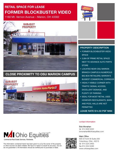
RETAIL SPACE FOR LEASEFORMER BLOCKBUSTER VIDEO1160 Mt. Vernon Avenue – Marion, OH 43302CLOSE PROXIMITY TO OSU MARION CAMPUSPROPERTY DESCRIPTION• FORMER BLOCKBUSTER VIEDOSPACE• 3,084 SF PRIME RETAIL SPACENEXT TO ADVANCE AUTO PARTSSTORE• LOCATED NEAR OSU MARIONBRANCH CAMPUS & NUMEROUSBIG BOX RETAILERS; MARION’SBUSIEST COMMERCIAL CORRIDOR• HIGHLY VISIBLE CORNER WITHTRAFFIC SIGNAL ACCESS,EXCELLENT SIGNAGE, ANDPLENTY OF PARKING• IDEAL FOR MOST RETAIL USESHOWEVER RESTAURANTS, BARSAND POOL HALLS ARE NOTPERMITTEDLEASE RATE $14.50 PSF NNNcontact in<strong>for</strong>mationBob Monahantel 614 629 5222bmonahan@ohioequities.comThe in<strong>for</strong>mation contained herein has been given to us by the owner of the propertyor other sources we deem reliable. We have no reason to doubt its accuracy, but wedo not guarantee it. All in<strong>for</strong>mation should be verified prior to purchase or <strong>lease</strong>.Main Office605 S Front St Suite 200Columbus, <strong>Ohio</strong> 43215tel 614 224 2400fax 614 224 5436www.ohioequities.com
FLOORPLAN1160 Mt. Vernon Avenue – Marion, OH 43302contact in<strong>for</strong>mationThe in<strong>for</strong>mation contained herein has been given to us by the owner of the property or other sourceswe deem reliable. We have no reason to doubt its accuracy, but we do not guarantee it. Allin<strong>for</strong>mation should be verified prior to purchase or <strong>lease</strong>.Bob Monahantel 614 629 5222bmonahan@ohioequities.com
NEARBY RETAILERS1160 Mt. Vernon Avenue – Marion, OH 43302contact in<strong>for</strong>mationBob Monahantel 614 629 5222bmonahan@ohioequities.com
AERIAL IMAGERY & LOCATION MAPS1160 Mt. Vernon Avenue – Marion, OH 43302contact in<strong>for</strong>mationBob Monahantel 614 629 5222bmonahan@ohioequities.com
Population SummaryMarket Profile1160 MT Vernon Ave, Marion, OH, 43302Rings: 1, 3, 5 mile radii Latitude: 40.58092Longitude: -83.098241 mile 3 miles 5 miles2000 Total Population 8,495 40,424 49,0222010 Total Population 8,451 42,269 49,9422012 Total Population 8,503 42,243 49,9852012 Group Quarters 116 5,407 5,4342017 Total Population 8,500 41,967 49,7122012-2017 Annual Rate -0.01% -0.13% -0.11%Household Summary2000 Households 3,704 15,651 18,4192000 Average Household Size 2.25 2.43 2.442010 Households 3,762 15,323 18,3482010 Average Household Size 2.22 2.41 2.432012 Households 3,776 15,283 18,3322012 Average Household Size 2.22 2.41 2.432017 Households 3,787 15,223 18,2882017 Average Household Size 2.21 2.40 2.422012-2017 Annual Rate 0.06% -0.08% -0.05%2010 Families 2,322 9,708 11,9662010 Average Family Size 2.78 2.95 2.942012 Families 2,324 9,658 11,9302012 Average Family Size 2.78 2.95 2.942017 Families 2,302 9,507 11,7742017 Average Family Size 2.79 2.96 2.942012-2017 Annual Rate -0.19% -0.31% -0.26%Housing Unit Summary2000 Housing Units 3,880 16,963 19,845Owner Occupied Housing Units 71.8% 59.7% 63.4%Renter Occupied Housing Units 23.6% 32.5% 29.4%Vacant Housing Units 4.5% 7.7% 7.2%2010 Housing Units 4,122 17,774 20,985Owner Occupied Housing Units 62.7% 50.5% 55.3%Renter Occupied Housing Units 28.5% 35.7% 32.1%Vacant Housing Units 8.7% 13.8% 12.6%2012 Housing Units 4,141 17,720 20,971Owner Occupied Housing Units 61.7% 49.5% 54.4%Renter Occupied Housing Units 29.5% 36.8% 33.0%Vacant Housing Units 8.8% 13.8% 12.6%2017 Housing Units 4,171 17,735 21,025Owner Occupied Housing Units 61.7% 49.7% 54.6%Renter Occupied Housing Units 29.1% 36.1% 32.4%Vacant Housing Units 9.2% 14.2% 13.0%Median Household Income2012 $38,234 $31,837 $33,7612017 $42,952 $35,856 $37,872Median Home Value2012 $112,311 $87,348 $92,3192017 $119,156 $91,547 $97,568Per Capita Income2012 $23,757 $17,664 $18,1152017 $25,597 $19,031 $19,570Median Age2010 44.1 38.4 39.02012 44.6 38.6 39.42017 45.6 39.1 39.9Data Note: Household population includes persons not residing in group quarters. Average Household Size is the household population divided by total households.Persons in families include the householder and persons related to the householder by birth, marriage, or adoption. Per Capita Income represents the income received byall persons aged 15 years and over divided by the total population.Source: U.S. Census Bureau, Census 2010 Summary File 1. Esri <strong>for</strong>ecasts <strong>for</strong> 2012 and 2017. Esri converted Census 2000 data into 2010 geography.Made with Esri Business AnalystMarch 18, 2013©2013 Esri www.esri.com/ba 800-447-9778 Try it Now! Page 1 of 5
2012 Households by IncomeMarket Profile1160 MT Vernon Ave, Marion, OH, 43302Rings: 1, 3, 5 mile radii Latitude: 40.58092Longitude: -83.098241 mile 3 miles 5 milesHousehold Income Base 3,776 15,281 18,329
2010 Population by AgeMarket Profile1160 MT Vernon Ave, Marion, OH, 43302Rings: 1, 3, 5 mile radii Latitude: 40.58092Longitude: -83.098241 mile 3 miles 5 milesTotal 8,453 42,268 49,9430 - 4 5.3% 6.3% 6.1%5 - 9 5.9% 5.9% 5.9%10 - 14 5.7% 5.7% 6.0%15 - 24 10.9% 13.6% 13.3%25 - 34 12.0% 14.1% 13.4%35 - 44 11.2% 13.3% 13.4%45 - 54 14.0% 15.0% 15.1%55 - 64 14.4% 12.1% 12.6%65 - 74 9.1% 6.8% 7.1%75 - 84 7.8% 4.9% 4.9%85 + 3.6% 2.3% 2.1%18 + 79.1% 78.3% 78.1%2012 Population by AgeTotal 8,503 42,242 49,9850 - 4 5.3% 6.3% 6.0%5 - 9 5.9% 5.8% 5.9%10 - 14 5.6% 5.6% 5.9%15 - 24 10.7% 13.5% 13.1%25 - 34 12.2% 14.3% 13.6%35 - 44 10.9% 13.0% 13.1%45 - 54 13.5% 14.6% 14.8%55 - 64 14.9% 12.6% 13.1%65 - 74 9.6% 7.2% 7.6%75 - 84 7.7% 4.8% 4.9%85 + 3.8% 2.3% 2.2%18 + 79.5% 78.7% 78.5%2017 Population by AgeTotal 8,500 41,968 49,7140 - 4 5.3% 6.2% 6.0%5 - 9 5.8% 5.8% 5.8%10 - 14 5.6% 5.6% 5.9%15 - 24 10.0% 12.7% 12.3%25 - 34 12.2% 14.3% 13.6%35 - 44 10.5% 12.7% 12.8%45 - 54 12.3% 13.7% 13.8%55 - 64 15.3% 13.0% 13.6%65 - 74 11.3% 8.5% 9.0%75 - 84 7.8% 5.0% 5.0%85 + 3.9% 2.4% 2.3%18 + 79.8% 78.9% 78.7%2010 Population by SexMales 3,957 22,782 26,546Females 4,494 19,487 23,3962012 Population by SexMales 3,990 22,809 26,615Females 4,513 19,434 23,3702017 Population by SexMales 3,991 22,682 26,494Females 4,509 19,285 23,218Source: U.S. Census Bureau, Census 2010 Summary File 1. Esri <strong>for</strong>ecasts <strong>for</strong> 2012 and 2017. Esri converted Census 2000 data into 2010 geography.March 18, 2013Made with Esri Business Analyst©2013 Esri www.esri.com/ba 800-447-9778 Try it Now! Page 3 of 5
2010 Households by TypeMarket Profile1160 MT Vernon Ave, Marion, OH, 43302Rings: 1, 3, 5 mile radii Latitude: 40.58092Longitude: -83.098241 mile 3 miles 5 milesTotal 3,762 15,324 18,348Households with 1 Person 33.0% 30.7% 28.9%Households with 2+ People 67.0% 69.3% 71.1%Family Households 61.7% 63.4% 65.2%Husband-wife Families 46.4% 41.5% 44.4%With Related Children 16.0% 16.1% 17.1%Other Family (No Spouse Present) 15.3% 21.9% 20.8%Other Family with Male Householder 4.0% 5.9% 5.7%With Related Children 2.4% 3.7% 3.6%Other Family with Female Householder 11.3% 15.9% 15.1%With Related Children 6.8% 11.2% 10.5%Nonfamily Households 5.3% 6.0% 5.8%All Households with Children 25.7% 31.7% 31.9%Multigenerational Households 2.3% 3.9% 3.9%Unmarried Partner Households 6.8% 9.2% 8.9%Male-female 6.4% 8.7% 8.4%Same-sex 0.4% 0.5% 0.5%2010 Households by SizeTotal 3,762 15,324 18,3451 Person Household 33.0% 30.7% 29.0%2 Person Household 37.5% 33.4% 34.5%3 Person Household 13.7% 15.5% 15.7%4 Person Household 9.9% 11.5% 11.9%5 Person Household 3.9% 5.5% 5.7%6 Person Household 1.4% 2.2% 2.2%7 + Person Household 0.7% 1.2% 1.1%2010 Households by Tenure and Mortgage StatusTotal 3,762 15,323 18,348Owner Occupied 68.7% 58.5% 63.2%Owned with a Mortgage/Loan 46.5% 38.3% 41.3%Owned Free and Clear 22.3% 20.2% 21.9%Renter Occupied 31.3% 41.5% 36.8%Data Note: Households with children include any households with people under age 18, related or not. Multigenerational households are families with 3 or more parentchildrelationships. Unmarried partner households are usually classified as nonfamily households unless there is another member of the household related to thehouseholder. Multigenerational and unmarried partner households are reported only to the tract level. Esri estimated block group data, which is used to estimatepolygons or non-standard geography.Source: U.S. Census Bureau, Census 2010 Summary File 1. Esri <strong>for</strong>ecasts <strong>for</strong> 2012 and 2017. Esri converted Census 2000 data into 2010 geography.Made with Esri Business AnalystMarch 18, 2013©2013 Esri www.esri.com/ba 800-447-9778 Try it Now! Page 5 of 5
Demographic and Income Profile1160 MT Vernon Ave, Marion, OH, 43302Ring: 1 mile radius Latitude: 40.58092Longitude: -83.09824Summary Census 2010 2012 2017Population 8,451 8,503 8,500Households 3,762 3,776 3,787Families 2,322 2,324 2,302Average Household Size 2.22 2.22 2.21Owner Occupied Housing Units 2,586 2,553 2,573Renter Occupied Housing Units 1,176 1,223 1,214Median Age 44.1 44.6 45.6Trends: 2012 - 2017 Annual Rate Area State NationalPopulation -0.01% 0.14% 0.68%Households 0.06% 0.28% 0.74%Families -0.19% 0.07% 0.72%Owner HHs 0.16% 0.48% 0.91%Median Household Income 2.35% 3.19% 2.55%2012 2017Households by Income Number Percent Number Percent
Demographic and Income Profile1160 MT Vernon Ave, Marion, OH, 43302Ring: 1 mile radius Latitude: 40.58092Longitude: -83.09824Trends 2012-20173Annual Rate (in percent)2.521.510.50AreaStateUSAPopulation Households Families Owner HHs Median HH IncomePopulation by AgePercent15141312111098765432100-4 5-9 10-14 15-19 20-24 25-34 35-44 45-54 55-64 65-74 75-84 85+201220172012 Household Income$25K - $34K14.5%$15K - $24K13.2%
Demographic and Income Profile1160 MT Vernon Ave, Marion, OH, 43302Ring: 3 mile radius Latitude: 40.58092Longitude: -83.09824Summary Census 2010 2012 2017Population 42,269 42,243 41,967Households 15,323 15,283 15,223Families 9,708 9,658 9,507Average Household Size 2.41 2.41 2.40Owner Occupied Housing Units 8,969 8,765 8,817Renter Occupied Housing Units 6,354 6,519 6,406Median Age 38.4 38.6 39.1Trends: 2012 - 2017 Annual Rate Area State NationalPopulation -0.13% 0.14% 0.68%Households -0.08% 0.28% 0.74%Families -0.31% 0.07% 0.72%Owner HHs 0.12% 0.48% 0.91%Median Household Income 2.41% 3.19% 2.55%2012 2017Households by Income Number Percent Number Percent
Demographic and Income Profile1160 MT Vernon Ave, Marion, OH, 43302Ring: 3 mile radius Latitude: 40.58092Longitude: -83.09824Trends 2012-20173Annual Rate (in percent)2.521.510.50AreaStateUSAPopulation Households Families Owner HHs Median HH IncomePopulation by AgePercent141312111098765432100-4 5-9 10-14 15-19 20-24 25-34 35-44 45-54 55-64 65-74 75-84 85+201220172012 Household Income2012 Population by Race$25K - $34K14.4%$35K - $49K15.8%$15K - $24K15.4%$50K - $74K15.5%
Demographic and Income Profile1160 MT Vernon Ave, Marion, OH, 43302Ring: 5 mile radius Latitude: 40.58092Longitude: -83.09824Summary Census 2010 2012 2017Population 49,942 49,985 49,712Households 18,348 18,332 18,288Families 11,966 11,930 11,774Average Household Size 2.43 2.43 2.42Owner Occupied Housing Units 11,603 11,402 11,470Renter Occupied Housing Units 6,745 6,930 6,818Median Age 39.0 39.4 39.9Trends: 2012 - 2017 Annual Rate Area State NationalPopulation -0.11% 0.14% 0.68%Households -0.05% 0.28% 0.74%Families -0.26% 0.07% 0.72%Owner HHs 0.12% 0.48% 0.91%Median Household Income 2.32% 3.19% 2.55%2012 2017Households by Income Number Percent Number Percent
Demographic and Income Profile1160 MT Vernon Ave, Marion, OH, 43302Ring: 5 mile radius Latitude: 40.58092Longitude: -83.09824Trends 2012-20173Annual Rate (in percent)2.521.510.50AreaStateUSAPopulation Households Families Owner HHs Median HH IncomePopulation by AgePercent141312111098765432100-4 5-9 10-14 15-19 20-24 25-34 35-44 45-54 55-64 65-74 75-84 85+201220172012 Household Income2012 Population by Race$25K - $34K14.4%$15K - $24K15.2%
Site Details Map1160 MT Vernon Ave, Marion, OH, 43302Ring: 1, 3, 5 Miles Latitude: 40.58092Longitude: -83.09824This site is located in:City: Marion cityCounty: Marion CountyState: <strong>Ohio</strong>ZIP Code: 43302Census Tract: 39101000700Census Block Group: 391010007002CBSA: Marion, OH Micropolitan Statistical Area (32020)Made with Esri Business AnalystMarch 18, 2013©2013 Esri www.esri.com/ba 800-447-9778 Try it Now! Page 1 of 1
Business Summary1160 MT Vernon Ave, Marion, OH, 43302Rings: 1, 3, 5 mile radii Latitude: 40.58092Longitude: -83.09824Data <strong>for</strong> all businesses in area 1 mile 3 miles 5 milesTotal Businesses: 297 1,675 1,842Total Employees: 3,826 22,702 27,104Total Residential Population: 8,470 42,199 49,910Employee/Residential Population Ratio: 0.45 0.54 0.54Businesses Employees Businesses Employees Businesses Employeesby SIC Codes Number Percent Number Percent Number Percent Number Percent Number Percent Number PercentAgriculture & Mining 7 2.2% 27 0.7% 38 2.2% 181 0.8% 46 2.5% 245 0.9%Construction 12 4.1% 35 0.9% 133 8.0% 733 3.2% 155 8.4% 852 3.1%Manufacturing 6 1.9% 41 1.1% 48 2.9% 2,143 9.4% 63 3.4% 4,821 17.8%Transportation 4 1.3% 7 0.2% 46 2.7% 606 2.7% 60 3.2% 841 3.1%Communication 2 0.6% 8 0.2% 12 0.7% 2,119 9.3% 12 0.7% 2,122 7.8%Utility 1 0.3% 4 0.1% 9 0.6% 57 0.3% 13 0.7% 65 0.2%Wholesale Trade 8 2.7% 54 1.4% 52 3.1% 545 2.4% 63 3.4% 766 2.8%Retail Trade Summary 103 34.6% 2,233 58.4% 379 22.7% 5,277 23.2% 399 21.7% 5,671 20.9%Home Improvement 5 1.6% 210 5.5% 23 1.4% 449 2.0% 25 1.4% 501 1.8%General Merchandise Stores 4 1.5% 497 13.0% 15 0.9% 756 3.3% 15 0.8% 759 2.8%Food Stores 8 2.7% 173 4.5% 35 2.1% 547 2.4% 38 2.1% 562 2.1%Auto Dealers, Gas Stations, Auto Aftermarket 13 4.4% 215 5.6% 60 3.6% 956 4.2% 63 3.4% 1,209 4.5%Apparel & Accessory Stores 7 2.3% 49 1.3% 17 1.0% 119 0.5% 17 0.9% 119 0.4%Furniture & Home Furnishings 6 2.2% 15 0.4% 21 1.2% 72 0.3% 24 1.3% 91 0.3%Eating & Drinking Places 33 11.1% 824 21.5% 110 6.6% 1,805 7.9% 113 6.1% 1,842 6.8%Miscellaneous Retail 26 8.9% 249 6.5% 100 6.0% 574 2.5% 104 5.6% 588 2.2%Finance, Insurance, Real Estate Summary 44 14.8% 232 6.1% 180 10.7% 883 3.9% 189 10.3% 914 3.4%Banks, Savings & Lending Institutions 17 5.8% 95 2.5% 42 2.5% 317 1.4% 44 2.4% 328 1.2%Securities Brokers 2 0.7% 8 0.2% 13 0.8% 60 0.3% 13 0.7% 60 0.2%Insurance Carriers & Agents 9 3.1% 30 0.8% 59 3.5% 203 0.9% 60 3.3% 206 0.8%Real Estate, Holding, Other Investment Offices 16 5.3% 99 2.6% 65 3.9% 303 1.3% 71 3.9% 319 1.2%Services Summary 104 35.1% 1,116 29.2% 662 39.5% 7,878 34.7% 720 39.1% 8,411 31.0%Hotels & Lodging 3 0.9% 36 0.9% 7 0.4% 75 0.3% 9 0.5% 83 0.3%Automotive Services 7 2.3% 80 2.1% 60 3.6% 232 1.0% 70 3.8% 259 1.0%Motion Pictures & Amusements 11 3.8% 51 1.3% 43 2.6% 176 0.8% 47 2.6% 231 0.9%Health Services 12 4.0% 140 3.6% 113 6.7% 2,890 12.7% 114 6.2% 2,927 10.8%Legal Services 0 0.0% 0 0.0% 30 1.8% 103 0.5% 30 1.6% 103 0.4%Education Institutions & Libraries 8 2.7% 412 10.8% 36 2.1% 1,330 5.9% 42 2.3% 1,523 5.6%Other Services 63 21.3% 398 10.4% 373 22.3% 3,073 13.5% 408 22.1% 3,284 12.1%Government 6 2.0% 65 1.7% 92 5.5% 2,217 9.8% 98 5.3% 2,328 8.6%Other 1 0.4% 3 0.1% 23 1.4% 62 0.3% 25 1.3% 66 0.2%Totals 297 100% 3,826 100% 1,675 100% 22,702 100% 1,842 100% 27,104 100%Source: Business data provided by Infogroup, Omaha NE Copyright 2012, all rights reserved. Esri <strong>for</strong>ecasts <strong>for</strong> 2011.March 18, 2013Made with Esri Business Analyst©2013 Esri www.esri.com/ba 800-447-9778 Try it Now! Page 1 of 2
Business Summary1160 MT Vernon Ave, Marion, OH, 43302Rings: 1, 3, 5 mile radii Latitude: 40.58092Longitude: -83.09824Businesses Employees Businesses Employees Businesses Employeesby NAICS Codes Number Percent Number Percent Number Percent Number Percent Number Percent Number PercentAgriculture, Forestry, Fishing & Hunting 1 0.2% 1 0.0% 5 0.3% 26 0.1% 7 0.4% 31 0.1%Mining 1 0.3% 8 0.2% 2 0.1% 18 0.1% 4 0.2% 37 0.1%Utilities 0 0.0% 0 0.0% 3 0.2% 40 0.2% 3 0.2% 40 0.1%Construction 12 4.1% 35 0.9% 136 8.1% 746 3.3% 158 8.6% 869 3.2%Manufacturing 7 2.3% 45 1.2% 56 3.3% 2,125 9.4% 71 3.8% 4,804 17.7%Wholesale Trade 8 2.7% 53 1.4% 49 2.9% 529 2.3% 59 3.2% 739 2.7%Retail Trade 68 22.9% 1,388 36.3% 258 15.4% 3,393 14.9% 273 14.8% 3,749 13.8%Motor Vehicle & Parts Dealers 10 3.4% 200 5.2% 49 2.9% 583 2.6% 52 2.8% 748 2.8%Furniture & Home Furnishings Stores 2 0.6% 3 0.1% 9 0.5% 40 0.2% 9 0.5% 45 0.2%Electronics & Appliance Stores 6 1.9% 25 0.7% 12 0.7% 49 0.2% 15 0.8% 63 0.2%Bldg Material & Garden Equipment & Supplies Dealers 5 1.6% 210 5.5% 23 1.4% 449 2.0% 25 1.3% 501 1.8%Food & Beverage Stores 8 2.7% 163 4.3% 30 1.8% 493 2.2% 32 1.7% 507 1.9%Health & Personal Care Stores 6 1.9% 33 0.9% 22 1.3% 153 0.7% 23 1.2% 157 0.6%Gasoline Stations 3 1.0% 15 0.4% 11 0.6% 373 1.6% 11 0.6% 461 1.7%Clothing & Clothing Accessories Stores 8 2.6% 53 1.4% 21 1.3% 141 0.6% 21 1.1% 142 0.5%Sport Goods, Hobby, Book, & Music Stores 7 2.2% 79 2.1% 22 1.3% 132 0.6% 24 1.3% 139 0.5%General Merchandise Stores 4 1.5% 497 13.0% 15 0.9% 756 3.3% 15 0.8% 759 2.8%Miscellaneous Store Retailers 11 3.6% 109 2.9% 42 2.5% 205 0.9% 43 2.3% 207 0.8%Nonstore Retailers 0 0.0% 0 0.0% 3 0.2% 18 0.1% 3 0.2% 19 0.1%Transportation & Warehousing 2 0.6% 5 0.1% 31 1.8% 412 1.8% 39 2.1% 585 2.2%In<strong>for</strong>mation 3 1.1% 66 1.7% 23 1.4% 2,287 10.1% 25 1.4% 2,295 8.5%Finance & Insurance 28 9.5% 134 3.5% 115 6.9% 582 2.6% 118 6.4% 596 2.2%Central Bank/Credit Intermediation & Related Activities 17 5.8% 95 2.5% 43 2.6% 318 1.4% 45 2.5% 329 1.2%Securities, Commodity Contracts & Other Financial 2 0.7% 8 0.2% 13 0.8% 60 0.3% 13 0.7% 60 0.2%Insurance Carriers & Related Activities; Funds, Trusts & 9 3.1% 30 0.8% 59 3.5% 203 0.9% 60 3.3% 206 0.8%Real Estate, Rental & Leasing 24 8.2% 127 3.3% 103 6.2% 530 2.3% 114 6.2% 597 2.2%Professional, Scientific & Tech Services 11 3.8% 46 1.2% 95 5.7% 548 2.4% 107 5.8% 667 2.5%Legal Services 0 0.1% 1 0.0% 33 2.0% 112 0.5% 33 1.8% 112 0.4%Management of Companies & Enterprises 0 0.0% 0 0.0% 1 0.1% 20 0.1% 1 0.1% 20 0.1%Administrative & Support & Waste Management & Remediation 9 3.0% 17 0.5% 55 3.3% 205 0.9% 64 3.5% 271 1.0%Educational Services 9 3.0% 359 9.4% 38 2.3% 1,281 5.6% 44 2.4% 1,476 5.4%Health Care & Social Assistance 20 6.6% 317 8.3% 170 10.2% 4,221 18.6% 176 9.6% 4,291 15.8%Arts, Entertainment & Recreation 6 2.0% 39 1.0% 33 2.0% 165 0.7% 36 2.0% 217 0.8%Accommodation & Food Services 37 12.3% 876 22.9% 119 7.1% 1,907 8.4% 125 6.8% 1,952 7.2%Accommodation 3 0.9% 36 0.9% 7 0.4% 75 0.3% 9 0.5% 83 0.3%Food Services & Drinking Places 34 11.4% 841 22.0% 112 6.7% 1,832 8.1% 115 6.3% 1,870 6.9%Other Services (except Public Administration) 45 15.1% 241 6.3% 264 15.8% 1,363 6.0% 291 15.8% 1,440 5.3%Automotive Repair & Maintenance 6 2.1% 78 2.0% 45 2.7% 188 0.8% 53 2.9% 212 0.8%Public Administration 6 2.0% 65 1.7% 94 5.6% 2,232 9.8% 100 5.4% 2,343 8.6%Unclassified Establishments 1 0.4% 3 0.1% 24 1.4% 70 0.3% 26 1.4% 85 0.3%Total 297 100% 3,826 100% 1,675 100% 22,702 100% 1,842 100% 27,104 100%Source: Business data provided by Infogroup, Omaha NE Copyright 2012, all rights reserved. Esri <strong>for</strong>ecasts <strong>for</strong> 2011.March 18, 2013Made with Esri Business Analyst©2013 Esri www.esri.com/ba 800-447-9778 Try it Now! Page 2 of 2
Traffic Count Map1160 MT Vernon Ave, Marion, OH, 43302Ring: 1, 3, 5 Miles Latitude: 40.58092Longitude: -83.09824Source: ©2012 Market Planning Solutions, Inc.March 18, 2013Made with Esri Business Analyst©2013 Esri www.esri.com/ba 800-447-9778 Try it Now! Page 1 of 1
Traffic Count Map - Close Up1160 MT Vernon Ave, Marion, OH, 43302Ring: 1, 3, 5 Miles Latitude: 40.58092Longitude: -83.09824Source: ©2012 Market Planning Solutions, Inc.March 18, 2013Made with Esri Business Analyst©2013 Esri www.esri.com/ba 800-447-9778 Try it Now! Page 1 of 1