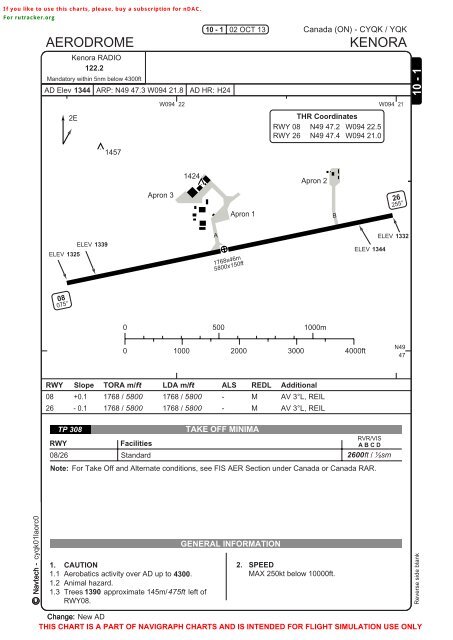
RNAV RWY 08 RNAV RWY 08
RNAV RWY 08 RNAV RWY 08
RNAV RWY 08 RNAV RWY 08

Create successful ePaper yourself
Turn your PDF publications into a flip-book with our unique Google optimized e-Paper software.
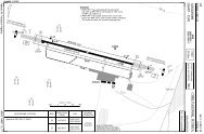
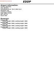
If you like to use this charts, please, buy a subscription for nDAC.For rutracker.orgAERODROMEKenora RADIO122.2Mandatory within 5nm below 4300ftAD Elev 1344 ARP: N49 47.3 W094 21.8 AD HR: H2410 - 1 02 OCT 13Canada (ON) - CYQK / YQKKENORA10 - 12EW094 22W094 21THR Coordinates<strong>RWY</strong> <strong>08</strong> N49 47.2 W094 22.5<strong>RWY</strong> 26 N49 47.4 W094 21.014571424Apron 2Apron 3Apron 1B26255°ELEV 1339ELEV 1325A1768x46m5800x150ftELEV 1332ELEV 1344<strong>08</strong>075°0 500 1000m0 1000 2000 3000 4000ftN4947<strong>RWY</strong> Slope TORA m/ ft LDA m/ ft ALS REDL Additional<strong>08</strong>26+0.1- 0.11768 / 58001768 / 58001768 / 58001768 / 5800--MMAV 3°L, REILAV 3°L, REILTP 3<strong>08</strong>TAKE OFF MINIMA<strong>RWY</strong>FacilitiesRVR/VISA B C D<strong>08</strong>/26 Standard2600ft / ½smNote: For Take Off and Alternate conditions, see FIS AER Section under Canada or Canada RAR.MINIMA NOT PUBLISHEDNavtech - cyqk01laorg0cyqk01laorc0GENERAL INFORMATION1. CAUTION2. SPEED1.1 Aerobatics activity over AD up to 4300.MAX 250kt below 10000ft.1.2 Animal hazard.1.3 Trees 1390 approximate 145m/ 475ft left of<strong>RWY</strong><strong>08</strong>.Reverse side blankChange: New ADTHIS CHART IS A PART OF NAVIGRAPH CHARTS AND IS INTENDED FOR FLIGHT SIMULATION USE ONLY