

Biodiversity Guide - The Intertwine
Biodiversity Guide - The Intertwine
Biodiversity Guide - The Intertwine

Create successful ePaper yourself
Turn your PDF publications into a flip-book with our unique Google optimized e-Paper software.
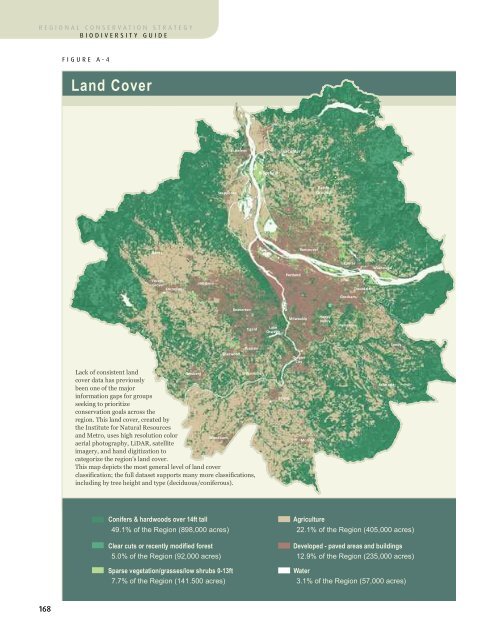
egional conservation strategybiodiversity guideappendix a Land Cover Mappingfigure A-4Land Coverfigure A-5Forest Patches & Tree CoverSt. HelensLaCenterSt. HelensRidgefieldRidgefieldScappooseBattleGroundScappooseBattleGroundBanksVancouverBanksVancouverForestGroveCorneliusHillsboroPortlandCamasWashougalTroutdaleGreshamForestGroveCorneliusHillsboroPortlandCamasWashougalTroutdaleGreshamBeavertonTigardLakeOswegoMilwaukieHappyValleyDamascusBeavertonTigardLakeOswegoMilwaukieHappyValleyDamascusSherwoodTualatinOregonCitySandyTualatinSherwoodOregonCitySandyLack of consistent landNewbergcover data has previouslybeen one of the majorinformation gaps for groupsseeking to prioritizeconservation goals across theregion. This land cover, created bythe Institute for Natural Resourcesand Metro, uses high resolution colorWoodburnaerial photography, LiDAR, satelliteimagery, and hand digitization tocategorize the region's land cover.This map depicts the most general level of land coverclassification; the full dataset supports many more classifications,including by tree height and type (deciduous/coniferous).WilsonvilleCanbyMolallaEstacadaNewbergTree cover provides avariety of useful functions;even a single tree canenhance air and water quality,provide wildlife habitat, andregulate temperature. However,patches of forest habitat that are 30Woodburnacres or larger provide valuableinterior habitat and are more likely tosupport sensitive species. Landoccupied by these large forest patchesrepresents 44% of the total RCS extent but only 24% of landwithin urban areas (even including Portland’s Forest Park).WilsonvilleCanbyMolallaEstacadaConifers & hardwoods over 14ft tall49.1% of the Region (898,000 acres)Agriculture22.1% of the Region (405,000 acres)Forest patches 30 acres or larger- 44% of the region. <strong>The</strong> largest of these patches are in themountainous, sparsely-populated fringes of the region.Clear cuts or recently modified forest5.0% of the Region (92,000 acres)Sparse vegetation/grasses/low shrubs 0-13ft7.7% of the Region (141.500 acres)Developed - paved areas and buildings12.9% of the Region (235,000 acres)Water3.1% of the Region (57,000 acres)Trees in patches smaller than 30 acresAll other land cover types- 54% of the region. Urban areas contain substantialtree cover but few large forest patches.- 46% of the region. This category includes developedlands, agriculture, grasses, water and shrubs.168 169

