METHODSCEWAP took advantage <strong>of</strong> the expertise <strong>of</strong> activebirders and pr<strong>of</strong>essional biologists by employing networks<strong>of</strong> volunteers. The <strong>Lab</strong> <strong>of</strong> <strong>Ornithology</strong> hired fieldassistants in 1997, 1998, and 1999 to cover areas thoughtto be potentially important breeding areas for ceruleans.These specific areas within states were systematicallysearched; however, coverage <strong>of</strong> entire states was <strong>of</strong>tenstill incomplete.Field protocols consisted primarily <strong>of</strong> surveyingknown sites (determined through state atlas workers,other birders, and published literature) to determinenumbers <strong>of</strong> pairs, breeding status <strong>of</strong> population, andconservation status <strong>of</strong> site. In addition, participants surveyedas many new or potential sites as possible, to identifynew breeding sites and determine status (as in thefirst project goal). At a small subset <strong>of</strong> sites with largeor important populations, additional data on nesting andforaging, as well as productivity and threats to populations,was available through collaborating researchers.Because <strong>of</strong> our reliance on volunteers and unsupervisedfield assistants, and the large differences in terrainand habitats surveyed, there was much variation inactual survey methods employed in the field. A majority<strong>of</strong> data came from variations on the “area-search”method, where observers moved through potential habitatsnoting presence and numbers <strong>of</strong> singing male <strong>Cerulean</strong><strong>Warbler</strong>s. Variations ranged from systematic surveysalong all navigable waterways by canoe in theMontezuma Wetlands Complex <strong>of</strong> NY (Bill Evans), todriving slowly along rural roads in northern NJ (JohnBenzinger), to hiking the Appalachian Trail in Virginia andNorth Carolina, to floating stretches <strong>of</strong> several rivers inMissouri, to systematically driving and hiking throughforested regions and conducting point counts whereverceruleans were detected (David Buehler), to spot-checkingisolated woodlots. Field surveys <strong>of</strong>ten used recorded<strong>Cerulean</strong> <strong>Warbler</strong> vocalizations (as needed) to elicit responsesfrom territorial males, approximate territorialboundaries (especially in linear habitats), and determinepairing status (females <strong>of</strong>ten respond to tapes within theirterritories). After visits to a site were completed, observerswere asked to attempt an estimate <strong>of</strong> the totalbreeding population <strong>of</strong> <strong>Cerulean</strong> <strong>Warbler</strong>s at that site.In addition to these CEWAP surveys, we receivedseveral datasets with point-count locations for <strong>Cerulean</strong><strong>Warbler</strong>s, <strong>of</strong>ten detected during more general bird surveys.In these cases, it is <strong>of</strong>ten impossible to know howmuch available habitat was covered or what proportion<strong>of</strong> a regional population <strong>of</strong> <strong>Cerulean</strong> <strong>Warbler</strong>s wassampled—these are retained in our <strong>Atlas</strong> as minimumestimates for these areas. In a few states we relied onadditional surveys conducted prior to CEWAP or as part<strong>of</strong> independent research efforts. Finally, some holes inour <strong>Atlas</strong> were filled by gleaning miscellaneous recordsfrom birding e-mail lists, recently published BreedingBird <strong>Atlas</strong>es, or by hounding certain birders and statebiologists until they told us what they knew.We instructed participants to define a “site” as anycontiguous patch <strong>of</strong> similar and suitable habitat surroundedby a different habitat type. Because <strong>of</strong> the greatvariation in survey methods and types <strong>of</strong> data we received,the actual designation <strong>of</strong> sites in our database ishighly inconsistent. These range from specific locations<strong>of</strong> individual <strong>Cerulean</strong> <strong>Warbler</strong>s within a larger contiguousarea, to politically defined State Park or WildlifeManagement Area boundaries, to entire river valleyswith their adjacent slopes. In all cases; however, a “site”represents a unique latitude and longitude provided bya participant and entered into our database. Althoughthis variation leads to difficulties in interpreting numbersor proportions <strong>of</strong> sites occupied in various regionsor states, this flexibility in our protocols enabled us toreceive the maximum amount <strong>of</strong> data from the widestgroup <strong>of</strong> volunteers and collaborators.All sites were located on topographic maps, and dataon habitat, landscape characteristics, and land ownershipwere noted on simple data forms. Specifically, fieldobservers recorded site location, latitude and longitude,elevation, history <strong>of</strong> disturbance, general habitat type(riparian, swamp forest, dry slope, etc.), three or moredominant tree species, and canopy height. This informationwas compiled and entered into a GIS databaseby <strong>Lab</strong> <strong>of</strong> <strong>Ornithology</strong> biologists.4
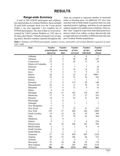
Range-wide SummaryA total <strong>of</strong> 280 CEWAP participants and collaboratorsreported data on <strong>Cerulean</strong> <strong>Warbler</strong>s; these included29 paid field assistants hired over the 3-year period(Table 1; see also Appendix 1 for complete list <strong>of</strong>CEWAP participants). The sum <strong>of</strong> data we received accountedfor 7,669 <strong>Cerulean</strong> <strong>Warbler</strong>s at 1,923 sites in28 states, plus Ontario. Virtually all reports were <strong>of</strong> singingmales; therefore numbers reported throughout thisRESULTS<strong>Atlas</strong> are assumed to represent number <strong>of</strong> territorialmales or breeding pairs. <strong>An</strong> additional 355 sites weresearched with no birds found; in general observers onlyreported positive sightings, and these do not representrandom samples <strong>of</strong> available areas or habitats. Note too,that “sites” ranged in scope from individual point-locationsto whole river valleys, so these data provide onlya rough indication <strong>of</strong> number <strong>of</strong> different areas that support<strong>Cerulean</strong> <strong>Warbler</strong> populations.Table 1. Summary <strong>of</strong> CEWAP participants, numbers <strong>of</strong> sites, and number <strong>of</strong> <strong>Cerulean</strong> <strong>Warbler</strong>s reported, by state,1997–1999.State Number Number Number Number Number<strong>of</strong> participants returning <strong>of</strong> sites <strong>of</strong> sites <strong>of</strong> birdssigned up data surveyed with birds foundAlabama 7 1 6 6 7Arkansas 12 4 48 46 145Connecticut 22 7 20 13 34District <strong>of</strong> Columbia 4 0 - - -Delaware 6 2 7 7 10Georgia 18 5 16 14 22Iowa 9 2 9 9 22Illinois 26 3 32 21 1000+Indiana 22 8 73 34 342Kansas 1 1 1 1 1Kentucky 17 8 113 59 140Massachusetts 22 6 11 10 18Maryland 17 6 11 9 16Maine 4 0 - - -Michigan 36 15 183 176 507Minnesota 17 4 57 57 103Missouri 14 5 32 31 301Mississippi 2 0 - - -Nebraska 2 1 1 1 1New Hampshire 5 0 - - -New Jersey 18 7 32 31 157New York 159 57 286 246 1068North Carolina 19 12 42 39 109Ohio 46 17 78 62 264Oklahoma 2 0 - - -Ontario 9 1 5 4 228Pennsylvania 81 38 206 182 548Rhode Island 3 1 1 0 0South Carolina 3 0 - - -South Dakota 2 2 2 2 3Tennessee 27 14 488 485 1210Virginia 48 15 106 64 152Vermont 13 2 4 3 3Wisconsin 25 10 60 59 174West Virginia 68 27 345 254 1124TOTALS 786 280 2274 1923 76695