Atlanta Ranger Station Historic District - Idaho State Historical Society
Atlanta Ranger Station Historic District - Idaho State Historical Society
Atlanta Ranger Station Historic District - Idaho State Historical Society

You also want an ePaper? Increase the reach of your titles
YUMPU automatically turns print PDFs into web optimized ePapers that Google loves.
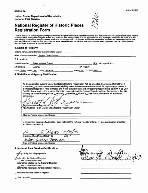
NFS Form 10-900(Revised Feb. 1993)0MB No. 10024-0018United <strong>State</strong>s Department of the InteriorNational Park ServiceNational Register of <strong>Historic</strong> PlacesRegistration FormThis form is for use in nominating or requesting determinations of eligibility for individual properties or districts. See instructions in How to Complete the National Registerof <strong>Historic</strong> Places Form (National Register Bulletin 16A). Complete each item by marking V in the appropriate box or by entering the information requested. If an itemdoes not apply to the property being documented, enter "N/A" for "not applicable." For functions, architectural classification, materials, and areas of significance, enteronly categories and subcategories from the instructions. Place additional entries and narrative items on continuation sheets (NFS Form 10-900a). Use a typewriter,word processor, or computer to complete all items.1. Name of Propertyhistoric name <strong>Atlanta</strong> <strong>Ranger</strong> <strong>Station</strong> <strong>Historic</strong> <strong>District</strong>__________________________________________other names/site number <strong>Atlanta</strong> Guard <strong>Station</strong>_____________________________________________2. Locationstreet & numberBoise National Forest____________city or town ____<strong>Atlanta</strong>___________________N/A vicinitystate <strong>Idaho</strong> code ID county Elmore code 039 zip code 836013. <strong>State</strong>/Federal Agency CertificationN/A not for publicationAs the designated authority under the National <strong>Historic</strong> Preservation Act, as amended, I hereby certify that this _Xnomination _request for determination of eligibility meets the documentation standards for registering properties inthe National Register of <strong>Historic</strong> Places and meets the procedural and professional requirements set forth in 36 CFRPart 60. In my opinion, the property _X_meets _does not meet the National Register criteria. I recommend that thisproperty be considered significant _nationally _statewide _XJocally. (_ See continuation sheet for additionalcomments,/Signature of certifying official/title / Date^KENNETH C. REID, Deputy <strong>State</strong> <strong>Historic</strong> Preservation Officer<strong>State</strong> or Federal agency and bureauIn my opinion, the property^meets _does not meet the National Register criteria. (_ See continuation sheet foradditional comments.)Signature of certifyingxJrficial/Title
<strong>Atlanta</strong> <strong>Ranger</strong> <strong>Station</strong> <strong>Historic</strong> <strong>District</strong>Name of Property<strong>Atlanta</strong>. Elmore County. <strong>Idaho</strong>City, County, and <strong>State</strong>5. ClassificationOwnership of Property(Check as many boxes as apply)_ private_ public-local_ public-<strong>State</strong>X public-FederalCategory of Property(Check only one box)_ building(s)X district_site_ structure_ objectNumber of Resources within Property(Do not include previously listed resources in the count.)Contributing Noncontributing10__________ buildings_____________ sites_____________ structures_____________ objects10 TotalName of related multiple property listing(Enter "N/A" if property is not part of a multiple property listing.)Number of contributing resources previously listed inthe National RegisterN/A____06. Function or Use<strong>Historic</strong> Functions(Enter categories from instructions)GOVERNMENT________OTHER: <strong>Ranger</strong> <strong>Station</strong>Current Functions(Enter categories from instructions)GOVERNMENT___________OTHER: Guard <strong>Station</strong>7. DescriptionArchitectural Classification(Enter categories from instructions)OTHER: Forest Service R-4Standard PlansMaterials(Enter categories from instructions)foundation CONCRETE______wallsWOOD: WeatherboardroofWOOD: Shingles_____other BRICK__________Narrative Description(Describe the historic and current condition of the property on one or more continuation sheets.)X See continuation sheet(s) for Section No. 7
<strong>Atlanta</strong> <strong>Ranger</strong> <strong>Station</strong> <strong>Historic</strong> <strong>District</strong>Name of Property<strong>Atlanta</strong>. Elmore County. <strong>Idaho</strong>City, County, and <strong>State</strong>8. <strong>State</strong>ment of SignificanceApplicable National Register Criteria(Mark "x" on one or more lines for the criteriaqualifying the property for National Register listing.)X A_ BX C_ DProperty is associated with events that havemade a significant contribution to the broadpatterns of our history.Property is associated with the lives of personssignificant in our past.Property embodies the distinctive characteristicsof a type, period, or method of construction, orrepresents the work of a master, or possesseshigh artistic values, or represents asignificant and distinguishable entity whosecomponents lack individual distinction.Property has yielded, or is likely to yield,information important in prehistory or history.Criteria Considerations(Mark "x" on all that apply.)Property is:_ A_ B_ C_ D_ E_ F_ Gowned by a religious institution or used forreligious purposes.removed from its original location.a birthplace or grave.a cemetery.a reconstructed building, object, orstructure.a commemorative property.less than 50 years of age or achievedsignificance within the past 50 years.Areas of Significance(Enter categories from instructions)CONSERVATION_______ARCHITECTUREPeriod of Significance1930-1942Significant Dates1933Significant Person(Complete if Criterion B is marked above)Cultural AffiliationArchitect/BuilderUSDA Forest Service (designer)Civilian Conservation Corps (builder)Narrative <strong>State</strong>ment of Significance(Explain the significance of the property on one or more continuation sheets.)X See continuation sheet(s) for Section No. 89. Major Bibliographical ReferencesBibliography(Cite the books, articles, and other sources used in preparing this form on one or more continuation sheets.)Previous documentation on file (NPS):_ preliminary determination of individual listing(36 CFR 67) has been requested _ Other <strong>State</strong> agency_ previously listed in the National Register_ previously determined eligible by the NationalRegister_ designated a National <strong>Historic</strong> Landmark_ recorded by <strong>Historic</strong> American Buildings Survey#______ recorded by <strong>Historic</strong> American EngineeringRecord #Primary location of additional data:_x_ <strong>State</strong> <strong>Historic</strong> Preservation OfficeX Federal agency_ Local government_ University_ OtherName of repository:X See continuation sheet(s) for Section No. 9
<strong>Atlanta</strong> <strong>Ranger</strong> <strong>Station</strong> <strong>Historic</strong> <strong>District</strong>Name of Property<strong>Atlanta</strong>. Elmore County. <strong>Idaho</strong>City, County, and <strong>State</strong>10. Geographical DataAcreage of property 24 acresUTM References(Place additional UTM references on a continuation sheet.)1 1/1 6/5/0/3/7/0 4/8/5/1/6/0/0 2 1/1 6/5/0/3/4/0 4/8/5/1/6/6/0Zone Easting Northing Zone Easting Northing3 1/1 6/5/0/4/3/0 4/8/5/1/8/3/0 4 1/1 6/5/0/6/6/0 4/8/5/1/9/6/0Verbal Boundary Description_____(Describe the boundaries of the property.)X See continuation sheet(s) for Section No. 10Boundary Justification__________(Explain why the boundaries were selected.)X See continuation sheet(s) for Section No. 1011. Form Prepared Byname/title Douglas W. Dodd. Consulting Historianorganization ____________________street & number 6750 El Colegio Rd. #326____city or town Goleta_________________date 12/10/93telephone (805) 562-6949state_CA_ zip code 93117Additional DocumentationSubmit the following items with the completed form:• Continuation Sheets• Maps: A USGS map (7.5 or 15 minute series) indicating the property's location.A Sketch map for historic districts and/or properties having large acreage or numerous resources.• Photographs: Representative black and white photographs of the property.• Additional items (Check with the SHPO or FPO for any additional items.)Prooertv Ownername USDA Forest Service. Boise National Foreststreet & numbercity or town __telephonestate __ zip codePaperwork Reduction Act <strong>State</strong>ment: This information is being collected for applications to the National Register of <strong>Historic</strong> Places to nominate properties for listing ordetermine eligibility for listing, to list properties, and to amend existing listings. Response to this request is required to obtain a benefit in accordance with the National<strong>Historic</strong> Preservation Act, as amended (16 U.S.C. 470 etseq.).Estimated Burden <strong>State</strong>ment: Public reporting burden for this form is estimated to average 18.1 hours per response including time for reviewing instructions, gatheringand maintaining data, and completing and reviewing the form. Direct comments regarding this burden estimate or any aspect of this form to the Chief, AdministrativeServices Division, National Park Service, P.O. Box 37127, Washington, DC 20013-7127; and the Office of Management and Budget, Paperwork Reductions Projects(1024-0018), Washington, DC 20503.
NPS Form 10-900-a UB No. 1024-0018(1993)United <strong>State</strong>s Department of the InteriorNational Park ServiceNational Register of <strong>Historic</strong> PlacesContinuation SheetSection number 7 Page 1 Name of Property <strong>Atlanta</strong> <strong>Ranger</strong> <strong>Station</strong> <strong>Historic</strong> <strong>District</strong>County and <strong>State</strong><strong>Atlanta</strong>. Elmore County. <strong>Idaho</strong>______DescriptionThe <strong>Atlanta</strong> <strong>Ranger</strong> <strong>Station</strong> <strong>Historic</strong> <strong>District</strong> consists often buildings situated on 24 acres of landon a terrace approximately 1,00 feet south of the Middle Fork Boise River. Originally theheadquarters of the Boise National Forest's <strong>Atlanta</strong> <strong>Ranger</strong> <strong>District</strong>, the <strong>Station</strong> is now used by theBoise National Forest as a base for work crews, a recreation rental cabin, and housing for therecreation cabin volunteer.The grounds: The <strong>Ranger</strong> <strong>Station</strong> was withdrawn from the public domain by the General LandOffice Commissioner in 1909. The site around the <strong>Ranger</strong> <strong>Station</strong> has been leveled. A low, stoneretaining wall visible north of the ranger's dwelling indicates that Civilian Conservation Corpsenrollees expended some effort in preparing the site for construction. Grass lawns have beenplanted around the ranger's dwelling, garage, office/bedroom, and guard's dwelling. Foundationplantings of annual flowers and lilac bushes ornament the ranger's dwelling. A flagpole marks theentrance to the ranger's front walk.The entire compound and pastures are enclosed by a rail fence. Much of the unlandscaped portionof the grounds remain in pasture for Forest Service livestock, as they have since the <strong>Station</strong>'sestablishment. The <strong>Station</strong>'s uplands remain in sagebrush, Douglas fr, and ponderosa and lodge polepine, while the areas along watercourses grow thick with willows.<strong>Ranger</strong>'s Dwelling (Building No. 1101): Originally built in 1933 as a standard, two-room,rectangular-plan R4-7 guard station dwelling, the ranger's house burned during the winter of 1936.The current dwelling, an identical R4-7, replaced it in 1937, and was subsequently altered in 1941by the addition of a two-room wing on the north elevation, creating a T-plan.Built on a concrete foundation over a basement, the wood-frame dwelling has a concrete slab porchdeck on the west elevation. With its three square pillars surmounted by a plain frieze panel, theporch spans the entire width of the gable end and constitutes the building's dominant visualelement. False-beveled drop siding, each board milled to resemble two narrow clapboards, clad theexterior surfaces. Corner boards define the edges of the exterior walls. Four-over-four, double-hungsash windows with plain surrounds, grouped in bays of two or three, constitute the primaryfenestration. These windows were a result of the 1941-42 remodeling and replaced the paired,six-pane sliding windows of the R4-7 plan. Three-pane hopper windows, set into the foundation,light the basement. Atop the building is an intersecting gabled roof with ridge boards, woodshingles, and exposed rafters. Like nearly all the other roofs at the <strong>Atlanta</strong> <strong>Ranger</strong> <strong>Station</strong>, thisdwelling's roof has a steep pitch of 45 degrees, to shed the high-country winter's heavy loads ofsnow. A brick interior chimney rises from the center of the dwelling. The dwelling is painted white,with a wood shingle roof stained green, and green window trim, in accordance with the 1935Building Construction Manual. From the exterior, it looks as it did in 1942.
NPS Form 10-900-a MB No. 1024-0018(1993)United <strong>State</strong>s Department of the InteriorNational Park ServiceNational Register of <strong>Historic</strong> PlacesContinuation SheetSection number 7 Page 2 Name of Property <strong>Atlanta</strong> <strong>Ranger</strong> <strong>Station</strong> <strong>Historic</strong> <strong>District</strong>County and <strong>State</strong><strong>Atlanta</strong>. Elmore County. <strong>Idaho</strong>______Inside, the building has a living room/office and kitchen in the original structure, and a bedroomand bathroom in the addition. Remodeling during the 1950s removed the walls between the kitchenand living room to open the floor plan, and changed the kitchen counters and cabinets, but theinterior retains its original wood floors and painted fiberboard walls.Built to house the <strong>Atlanta</strong> <strong>District</strong> <strong>Ranger</strong> and his family, the house later became the quarters of theFire Control Officer after the district headquarters moved to Dutch Creek <strong>Ranger</strong> <strong>Station</strong> about1960. Today, the ranger's dwelling houses a volunteer who maintains the <strong>Idaho</strong> City <strong>Ranger</strong><strong>District</strong>'s recreational rental cabins.<strong>Ranger</strong>'s Woodshed (Building No. 1612): This woodshed (1939), linked to the ranger dwelling'sback door by a narrow concrete walk, was built on the R4-66 standard plan. It has a concretefoundation, earthen floor, wood-frame construction clad with false-beveled, drop siding and cornerboards, and a standard-pitched, gabled wood shingle roof with ridge boards and exposed rafters. Awide, brace door in the gable end of the north elevation offers access to the shed, while a six-panefixed window provides light from the east wall.The woodshed is painted white with a green-stained roof and appears as it did in 1939.Two-Car Garage (Building No. 1392): This R4-20 two-car garage, built in 1933 on a rectangularplan, has a concrete foundation and floor, wood-frame construction, and a steeply pitched, gabledroof with ridge boards, wood shingles, and exposed rafters. The exterior walls are clad withwooden, false-beveled drop siding with corner boards. Six-pane, casement windows with simplesurrounds constitute the fenestration. A five-panel door on the north elevation affords access, whiletwo large sliding garage doors, with four cross-bucks each, allow entry for vehicles. A grease pitand storage cabinets, all original, remain inside. A floodlight hangs over the doors on the easterngable end, while a non-historic stovepipe emerges from the wall in the western gable end. Thegarage is painted white with green window trim and a green-stained roof. During the historicperiod, the crossbucks were painted green rather than the current white. The building continues inits original uses today—as a garage, storeroom, and shop—and has suffered but few alterations to itshistorical character.Office and Bedroom (Building No. 1124): Built in 1933, this one-story rectangular R4-51 officeand bedroom provided office space and sleeping quarters for a forest guard. The office is built on aconcrete foundation, has wood-frame construction, and a steeply pitched, gabled roof with ridgeboards, wood shingles, and exposed rafters. A brick interior chimney pierces the roof on the northelevation. The walls are clad with wooden false-beveled drop siding with cornerboards. Afull-width porch with three square pillars dominates the front, eastern gable end. Tongue-in-groovefloorboards form the deck of the porch. A screened, four-panel, three-pane front door offers accessto the office portion of the building. The building is fenestrated with screened six-over-six,
NPS Form 10-900-a MB No. 1024-0018(1993)United <strong>State</strong>s Department of the InteriorNational Park ServiceNational Register of <strong>Historic</strong> PlacesContinuation SheetSection number 7 Page 3 Name of Property <strong>Atlanta</strong> <strong>Ranger</strong> <strong>Station</strong> <strong>Historic</strong> <strong>District</strong>County and <strong>State</strong><strong>Atlanta</strong>. Elmore County. <strong>Idaho</strong>______double-hung sash windows with simple surrounds. Gable ends are penetrated by a triangular,louvered vent. The rear porch, on the west elevation, has been enclosed with plywood and beveledceiling boards to house an indoor bathroom. A wood-framed sliding window has been installed onthe south elevation of the former porch. The building is painted white with green window trim anda green-stained roof. With the exception of the rear porch enclosure, the building appears as it didin 1933.The interior was modernized in the 1950s, when the woodstove, folding table/cupboard, andtelephone stand were removed. This building became a bunkhouse for field crews and is now arecreational rental cabin: the office area is a bedroom and the former bedroom serves as the kitchen,while the rear porch is now the bathroom. The original fiberboard walls remain, but the wood floorshave been covered with linoleum.Single Unit Latrine (Building No. T-U: This latrine serves the garage (1392) and office/bedroom(1124) buildings. Built on the standard R4-70 plan, this wood-framed privy has a steeply pitched,gabled roof with ridge boards, wood shingles, exposed rafters, and narrow bargeboards. The wallsare clad with wooden, false-beveled drop siding with corner boards. The small, square building sitson a concrete foundation. Two diamond-shaped vents in the side walls provide ventilation, as doesa triangular vent in the gable above the five-panel door. The door has a simple surround. Inside, thelatrine appears to retain its original wooden seat. The latrine is painted white with a green-stainedroof and appears as it did when constructed in 1933.Dwelling (Building No. 1102): This R4-7 dwelling, built in 1934, is exemplary of the most popularguard station plans on the Boise National Forest. It is a one-story, rectangular building on aconcrete foundation with wood-frame construction and a steeply pitched, gabled roof with ridgeboards, wood shingles, and exposed rafters. It has a porch similar to the R4-51 in design andmaterials, but is slightly wider. The walls are clad in wooden, false-beveled drop siding with cornerboards. Pairs of six-pane sliding windows, with simple surrounds, provide light and ventilation.Gable ends are penetrated by a triangular, louvered vent. A brick, interior chimney rises from theroof on the north elevation. A rear addition, which runs the width of the west elevation, has beenbuilt on a concrete-block foundation. The exterior treatments of false-beveled siding, cornerboards,wood shingle roofing, and exposed rafters have all been replicated, and the effect is sympathetic tothe building's character. A vertical board covering the joint between the siding on the new and oldparts of the building clearly demarcates the addition. The dwelling is painted white with greenwindow trim and a green-stained roof. With the exception of the rear addition, the building'sappearance is essentially unchanged from 1934.Inside, in 1956, the wall between the living room and kitchen was removed, and new kitchencabinets, counters, and a linoleum floor were installed. Original features such as the foldingtable/cupboard, woodstove, and telephone stand were removed during the remodeling. Originally
NPS Fomi 10-900-a UB No. 1024-0018(1993)United <strong>State</strong>s Department of the InteriorNational Park ServiceNational Register of <strong>Historic</strong> PlacesContinuation SheetSection number 7 Page 4 Name of Property <strong>Atlanta</strong> <strong>Ranger</strong> <strong>Station</strong> <strong>Historic</strong> <strong>District</strong>County and <strong>State</strong><strong>Atlanta</strong>. Elmore County. <strong>Idaho</strong>___________a forest guard/assistant ranger's dwelling, the building was converted to a bunkhouse for fieldcrews. An interior bathroom was also installed.Single Unit Latrine (Building No. T-2): This latrine served the guard dwelling (1102). Built on thestandard R4-70 plan, this wood-framed privy has a steeply pitched, gabled roof with ridge boards,wood shingles, exposed rafters, and narrow bargeboards. The walls are clad with woodenchannel-grooved beveled siding with corner boards. The small, square building sits on a concretefoundation. Two diamond-shaped vents in the side walls provide ventilation, as does a triangularvent in the gable above the five-panel door. The door has a simple surround. Inside, the latrineappears to retain its original wooden seat. The latrine is painted white with a green-stained roof andappears as it did when constructed in 1934.Ice House/Cellar (Building No. 1445): This 10-foot-by-10-foot icehouse/cellar was built in 1932 toprovide food storage for personnel at <strong>Atlanta</strong> <strong>Ranger</strong> <strong>Station</strong>. It is not built to a standard plan and issmaller than the R4-63 icehouse. Built on a concrete foundation, the icehouse is aone-and-one-half-story building with a steeply pitched, gabled roof. Double-wall construction,with an insulating layer in between, maintained a low temperature inside.The roof has ridge boards, exposed rafters, narrow bargeboards, and is covered with wood shingles.The exterior is clad with channel-grooved beveled wooden siding with corner boards. A small door,clad in beveled siding and located in the gable, allows ventilation. Entry to the main storage area of theicehouse is provided by a double-door arrangement which improves the building's insulation. Theexterior door is insulated. Both exterior doors have simple surrounds. The cellar is currently used tostore food and beverages as part of the <strong>Atlanta</strong> Guard <strong>Station</strong>'s fire cache. The icehouse is painted whitewith a green-stained roof and appears as it did when constructed.Gas House (Building No. 1439): The gashouse, currently used to store fuel and oil, appears to haveoriginally been the tool storeroom indicated on the 1939 Improvement Plan. It has been moved afew yards to the northwest and now stands at the end of the driveway, where the R4-33 Shop andStorehouse building stood. This building was built in 1930 and is not an example of the RegionFour standard plans. It was incorporated into the CCC-built <strong>Atlanta</strong> <strong>Ranger</strong> <strong>Station</strong> compound in1933. The gashouse is a one-story, rectangular building with a steeply pitched, gabled roof. Theroof has ridge boards, exposed rafters and wood shingles. It has a concrete foundation, and itswood-framed walls are clad with channel-grooved beveled siding with corner boards. Thefive-panel door with a plain surround in the side wall on the south elevation has been reinforcedwith sheet metal over the bottom panel. A six-pane casement window in the west gable and the pairof six-pane sliding windows on the north elevation all have plain surrounds. The gashouse ispainted white with green window trim and a green-stained roof.
NPS Form 10-900-a MB No. 1024-0018(1993)United <strong>State</strong>s Department of the interiorNational Park ServiceNational Register of <strong>Historic</strong> PlacesContinuation SheetSection number 7 Page 5 Name of Property <strong>Atlanta</strong> <strong>Ranger</strong> <strong>Station</strong> <strong>Historic</strong> <strong>District</strong>County and <strong>State</strong><strong>Atlanta</strong>. Elmore County. <strong>Idaho</strong>______Barn (Building No. 133U: The four-horse barn (R4-11), built in 1933-34, housed the saddle stockused by the ranger and forest guards in patrolling their backcountry district. Pack strings alsosupplied the district's fire lookouts. The one-and-one-half-story, rectangular barn has a concretefoundation, wood-framed construction, false-beveled wooden siding with corner boards, and asteeply pitched, gabled roof with ridge boards and exposed rafters, covered by wood shingles. Thesliding two-panel/cross-buck doors with concrete ramps on the south, west, and north elevationsgive access to the pasture and corral. The hayloft doors are each one panel, with plain surrounds.The remnants of a hay hoist are located in the gable of the south elevation. Two pairs of four-panecasement windows fenestrate the west elevation, while five four-pane casement windows providelight on the east elevation. The south elevation has one four-pane casement window, and a pair ofthem in the north elevation gable illuminate the hayloft. All have plain surrounds. The barn ispainted white with green window trim and a green-stained roof. During the historic period, thecross-bucks on the sliding doors were painted green, rather than the present white.Inside, the barn has four stalls, tack storage, and a rodent-proof feed room. A ladder leads through acrawlspace to the hayloft, which presently houses a fire cache, rather than hay. The barn's interior isin excellent condition. With no significant alterations (other than an easily removed windsockmounted on the gable of the south elevation), the barn has maintained its historical integrity.Other Structures: The <strong>Atlanta</strong> <strong>Ranger</strong> <strong>Station</strong> also includes driveways, walkways, and fences, asshown on Map 1. The only major change from the 1939 Improvement Plan map is the eliminationof the circular drive in the center of the compound. Years of use have formed one large parkingarea. The pasture fences have been repaired and replaced in the course of routine maintenance. Thepresent fences are of post-and-rail construction. A concrete pad with a metal lid indicates thelocation of the <strong>Station</strong>'s well, just south of the ranger's dwelling. A stone retaining wall lies justinside the fence to the north of the ranger's dwelling.Some other structures, shown on the 1939 Improvement Plan map, are no longer extant or havebeen removed from the <strong>Station</strong>. The R4-33 Storehouse and Shop building, built in the 1930s as partof the compound, was moved to Dutch Creek <strong>Ranger</strong> <strong>Station</strong> as part of the transfer of the <strong>Atlanta</strong><strong>Ranger</strong> <strong>District</strong> headquarters. The tiny gashouse shown in the northwest corner of the compound nolonger exists, nor do the R4-66 woodshed (behind the guard dwelling and office buildings) or theR4-70 latrine associated with the ranger's dwelling.Recent Intrusions: <strong>Atlanta</strong> <strong>Ranger</strong> <strong>Station</strong> has been relatively unmarred by recent intrusions. Aunobtrusive helipad occupies part of the pasture northeast of the barn and a wooden walkwayextends across the sometime-boggy pasture to provide access. A low-profile grease pit for vehiclemaintenance, constructed from railroad ties, is situated just west of the gashouse.
NPS Form 10-900-a UB No. 1024-0018(1993)United <strong>State</strong>s Department of the InteriorNational Park ServiceNational Register of <strong>Historic</strong> PlacesContinuation SheetSection number 8 Page 2 Name of Property <strong>Atlanta</strong> <strong>Ranger</strong> <strong>Station</strong> <strong>Historic</strong> <strong>District</strong>County and <strong>State</strong><strong>Atlanta</strong>. Elmore County. <strong>Idaho</strong>______office/bedroom, a shop/storeroom, a four-horse barn, a two-car garage, and latrines. Because the<strong>Station</strong> adjoined the town of <strong>Atlanta</strong> (a nominally urban area) the Forest Service BuildingConstruction Manual called for frame construction, white painted siding, green trim, andgreen-stained shingle roofs for the buildings in the compound. The ranger's dwelling burned to theground on Christmas Eve 1936 and was rebuilt in 1937, and expanded in 1941-42.<strong>Atlanta</strong> <strong>Ranger</strong> <strong>Station</strong> served as headquarters for the Boise National Forest's <strong>Atlanta</strong> <strong>Ranger</strong><strong>District</strong> (D-4), until about 1960, when the district headquarters was removed to Dutch Creek<strong>Ranger</strong> <strong>Station</strong>, approximately 15 miles down the Middle Fork Boise River. The facility became aguard station at that time and ultimately it became part of the Boise <strong>Ranger</strong> <strong>District</strong> (D2) whenreorganization eliminated the <strong>Atlanta</strong> <strong>District</strong> in 1972. The Boise <strong>Ranger</strong> <strong>District</strong> was carved up in1993, and <strong>Atlanta</strong> Guard <strong>Station</strong> came under the jurisdiction of the <strong>Idaho</strong> City <strong>Ranger</strong> <strong>District</strong>(D-3). While the largest Forest Service facility in the area is Dutch Creek Work Center, <strong>Atlanta</strong>Guard <strong>Station</strong> remains in use as work station, fire cache, base for field crews, and a jumping-offplace for the Sawtooth National Recreation Area's wilderness rangers. The Intermountain Region'snew recreation rental cabin program has given a new use to the office/bedroom building at <strong>Atlanta</strong>,and a volunteer in charge of maintaining nearby rental cabins now resides in the old <strong>Atlanta</strong>ranger's dwelling.<strong>Historic</strong>al Significance:<strong>Atlanta</strong> <strong>Ranger</strong> <strong>Station</strong> <strong>Historic</strong> <strong>District</strong> is significant because it represents two important themes inthe history of the Boise National Forest: the development and evolution of administrative facilities,and the role of the Civilian Conservation Corps in developing the Forest's administrativecapabilities between 1933 and 1942. <strong>Idaho</strong> had 163 CCC camps—more than any state exceptCalifornia—and <strong>Idaho</strong> ranked second nationwide in CCC-related investment (Alexander 1987: 104;Schwantes 1991: 204). At the time, the CCC effort represented the largest expenditure of moneyand manpower by the Forest Service. Within a decade, the agency built new stations—composed ofneat and trim architect-designed buildings—to replace the minimal and ramshackle stationsdesigned and built in the previous 20 years by the rangers themselves. With the New Deal'semphasis on conservation and planning, Forest Service staffs found themselves with a largerworkload. The new, larger, and more plentiful facilities of the CCC period helped the agency tobetter carry out their expanding duties.While the <strong>Atlanta</strong> <strong>Station</strong>'s icehouse/cellar and gashouse predate the CCC construction period, CCCenrollees built the rest of the buildings. The compound reflects the mandates of the Region 4Building Construction Manual: the buildings be laid out in an orderly fashion from a surveyedcenter point, painted uniformly and in accordance with the color scheme prescribed by their setting,and conform with approved building plans. Standard plans helped to reduce building costs, speedconstruction, and reflect a uniform design that would help project an image of efficiency andpermanence to the public.
NPS Form 10-900-a UB No. 1024-0018(1993)United <strong>State</strong>s Department of the InteriorNational Park ServiceNational Register of <strong>Historic</strong> PlacesContinuation SheetSection number 8 Page 3 Name of Property <strong>Atlanta</strong> <strong>Ranger</strong> <strong>Station</strong> <strong>Historic</strong> <strong>District</strong>County and <strong>State</strong><strong>Atlanta</strong>. Elmore County. <strong>Idaho</strong>____________During the New Deal period, all ten ranger districts on the Boise National Forest (and parts of theold Payette National Forest that merged with the Boise National Forest in 1944) were served byadministrative compounds constructed in whole or in part by CCC crews. Of those, <strong>Atlanta</strong> <strong>Ranger</strong><strong>Station</strong> is the best remaining example of a New Deal-era Forest Service ranger districtheadquarters. It represents administrative sites of the 1930-1950 period and reflects theorganization and mission of the agency. During the 1930s and 1940s, stations were usually staffedby a seasonal or year-round ranger and a seasonal assistant (Otis, 1986: 201). The <strong>Atlanta</strong> <strong>Ranger</strong><strong>Station</strong> housed a year-round ranger and his family and a seasonal assistant, characteristic of theForest Service during the period.Most district headquarters grew and evolved over the years, as the agency's mission expanded. Newbuildings were erected to accommodate larger staffs; old buildings were moved, converted, or eventorn down as they were no longer needed for their original purposes. <strong>Atlanta</strong> <strong>Ranger</strong> <strong>Station</strong>escaped these changes because it had been "demoted." Dutch Creek <strong>Ranger</strong> <strong>Station</strong> became the<strong>Atlanta</strong> district headquarters around 1960, and funding for new construction and expansion flowedthere during the 1960s and 1970s. As a result, <strong>Atlanta</strong> <strong>Ranger</strong> <strong>Station</strong> retained nearly all of itshistoric buildings, without major character-altering exterior modifications. Thebuildings—excepting the gashouse—remain in their original positions, reflecting the orderly layoutof a New Deal-period administrative site. While the historic buildings have been preserved, nonon-historic buildings intrude upon the <strong>Station</strong>'s historic character and scale. <strong>Historic</strong> photographs,building plans, and maps show the <strong>Station</strong>'s original appearance and confirm that the site retains itshistorical integrity today. As the best surviving example of a standard-plan, Depression-era rangerstation on the Boise National Forest, <strong>Atlanta</strong> <strong>Ranger</strong> <strong>Station</strong> embodies "the distinctivecharacteristics of a type, period, or method of construction." Because of its links to the CivilianConservation Corps, which transformed the landscape of the public lands between 1933 and 1942,<strong>Atlanta</strong> <strong>Ranger</strong> <strong>Station</strong> "is associated with events that have made a significant contribution to thebroad patterns of our history." For these two compelling reasons, <strong>Atlanta</strong> <strong>Ranger</strong> <strong>Station</strong> deserveslisting on the National Register of <strong>Historic</strong> Places.
NPS Form 10-900-a UB No. 1024-0018(1993)United <strong>State</strong>s Department of the InteriorNational Park ServiceNational Register of <strong>Historic</strong> PlacesContinuation SheetSection number 9 Page 1 Name of Property <strong>Atlanta</strong> <strong>Ranger</strong> <strong>Station</strong> <strong>Historic</strong> <strong>District</strong>County and <strong>State</strong><strong>Atlanta</strong>. Elmore County. <strong>Idaho</strong>______BibliographyAlexander, Thomas G. The Rise of Multiple Use Management in theIntermountain West: A History of Region Four of the ForestService. FS-399. Washington, D.C.: U.S. Government PrintingOffice, 1987.Attebery, Jennifer Eastman. Building <strong>Idaho</strong>: An ArchitecturalHistory. Moscow: University of <strong>Idaho</strong> Press, 1991.Otis, Alison, William Honey, Thomas Hogg, and Kimberly Lakin.The Forest Service and the Civilian Conservation Corps-19331942. FS-395. Washington, D.C.: U.S. Government PrintingOffice, 1986.Schwantes, Carlos. In Mountain Shadows: A History of <strong>Idaho</strong>.Lincoln: University of Nebraska Press, 1991.Smith, Elizabeth M. History of the Boise National Forest 1905-1976. Boise: <strong>Idaho</strong> <strong>State</strong> <strong>Historic</strong>al <strong>Society</strong>, 1983.USDA Forest Service, Intermountain Region, Boise National Forest.<strong>Atlanta</strong> <strong>Ranger</strong> <strong>District</strong> 5650 (Buildings, Water, andSanitation) File.. L-<strong>Station</strong>s-Boise-Montezuma R.S. File... Improvement Plans, Region Four, Boise National Forest,1939. Boise National Forest <strong>Historic</strong>al Files, Boise, ID.
NFS Form 10-900-a MB No. 1024-0018(1993)United <strong>State</strong>s Department of the InteriorNational Park ServiceNational Register of <strong>Historic</strong> PlacesContinuation SheetSection number 10 Page 1 Name of Property <strong>Atlanta</strong> <strong>Ranger</strong> <strong>Station</strong> <strong>Historic</strong> <strong>District</strong>County and <strong>State</strong><strong>Atlanta</strong>. Elmore County. <strong>Idaho</strong>______UTM References (con't.)5. I/I 6/5/0/8/5/0 4/8/5/1/6/2/0/Easting NorthingVerbal Boundary Description:The boundary of the nominated property is delineated by the polygon whose vertices are marked byreferences points 1, 2, 3, 4 and 5 on the enclosed <strong>Atlanta</strong> West, <strong>Idaho</strong>, USGS Quadrangle map.Boundary Justification:The boundary of the nominated property was selected to correspond with the boundaries of the<strong>Ranger</strong>/Guard <strong>Station</strong> site as originally established by the Montezuma <strong>Ranger</strong> <strong>Station</strong> site in 1909. Allhistoric buildings at the <strong>Atlanta</strong> <strong>Ranger</strong> <strong>Station</strong> <strong>Historic</strong> <strong>District</strong> are situated inside this boundary.
MAP I:1939 Improvement Plan,Adanta <strong>Ranger</strong> <strong>Station</strong>I «r; « - ^:.- .-.»t>«'..— •• -.i* — •.* o.'^La>- • -CENTRAL POINT B£>«INGSSOB-NO i DISTANCE TQ COM>• a* / *n rr •u oo' t no 'ttoo't nil •it 10- H*.I •1* >«' *»r • •n of u • • •»* ae- »ua •ji ^# ')^ j * *« «r /w» - -i .u .M r /** • -!«• 9«T /OO J •t i 90' t /•// -1*1 M'f »•« « • -• *' •»' / »«J« 9 -auilOiMC Of* OBJECTJ f /«,« -0-J/- »••-i ir j*0* < t ro«f «OOMv« iro*f*oowI/ «»-'«•' *'*/•**fv CIPfl4/*< -
MAP 2:<strong>Atlanta</strong> Guard <strong>Station</strong>1993MAP 2:<strong>Atlanta</strong> Guard <strong>Station</strong>,1993Drawn by Douglas W. Dodd
Ql ]° \LSt^ V>joo|V
•MM
NACo.s,1)10fc,7
0WcoJsUJ (A).o i f
3.T3tVv7
II Jfil
vuJJ^I
.Co,Io l-
,, Cb vTPr:fe-7-
I,,*k>u*H'4,sA.
u10
,0{I6Z«'7tf
l AH*JU\^/Z- , Xb7-v-,
"9'I.ao02ipir
| v-for B*\7- # ft ^
Im'4
!< ;2.
z3-———I
I >, /i i^AhqtA.vH^v)^J-^V^Wfl^ PH, ^)fc>l«3i -• -W-^^o Jfce, fesrpD
A)1/111 of 16
6- -~. f,