Appalachians - Whitehorse Gear
Appalachians - Whitehorse Gear
Appalachians - Whitehorse Gear
- No tags were found...

You also want an ePaper? Increase the reach of your titles
YUMPU automatically turns print PDFs into web optimized ePapers that Google loves.
228178PENNSYLVANIA422Harrisburg2837632215833081Gettysburg3CYorkLancasterWaynesboroHanover15A81700 13 26 39 mi.195WESTVIRGINIA34070Baltimore270MARYLAND95VIRGINIA495Annapolis9766395295Washington21195301CHAPTER
The High Water Mark Gettysburg, PennsylvaniaBefore the War Between the States, Gettysburg was a sleepy little town in therolling piedmont of southern Pennsylvania. Three days in early July of 1863ensured that it would never sleep again. The worst battle since the war’s inceptiontwo years earlier left Gettysburg littered with the devastating legacyof bloodshed.In the end, the Battle of Gettysburg claimed 51,000 casualties. Five thousandhorses, broken cannons, shelled and burned homes, trees felled byheavy fire, and soldiers, some still barely alive, were scattered across thefields. The wise and considered words of Abraham Lincoln’s GettysburgAddress (loc.gov/exhibits/gadd/) some months later helped people understandwhat had happened there.Little by little, as the nation pieced itself together after the end of the war,monuments were erected to commemorate the dead. Together with cannonplacements, they total over 1,000 (gettysburgguide.com/mondx.html). ThePennsylvania maintains and celebrates its history.CHAPTER
16The Gettysburg Hotel offers accommodations for the discriminating rider.battlefield has been preserved in its original state. But most of all, the shadowsand spirits of those who were here still roam the fields and woods, at times sotangible you can feel them walk through you as you look across the battlefield.Place your hand on a cannon and it still feels warm. If you don’t believe inghosts or spirits when you come here, you will when you leave.Today the town rests a bit easier, though it still does not sleep. Peoplefrom around the world are drawn to this town, some for the glory, some tolearn, others to remember. Fortunately for the motorcyclist, there is ampleopportunity to experience all three from the seat of your motorcycle. Thereare 40 miles of scenic tours marked in the immediate area, and the tours inthis section venture well beyond those limits. If you aren’t tied to a particularschedule and don’t plan to attend a battle reenactment (details follow), thebest time of year to visit Gettysburg is either side of the summer vacationseason. April, May, September, and October offer fine riding weather withless competition for travel resources from the masses.In town, you’ll want to visit several places associated with GettysburgNational Military Park (nps.gov/gett/). The first is the visitor center, whichhouses the museum and electric map room. The free museum features a collectionof artifacts displayed and interpreted in typically excellent NationalCHAPTER
17Park form. Get your National Parks Passport stamped here. Behind the centeris an electric map room with a 30-minute program that helps you understandwhat happened more clearly when you go out to the battlefield and seethings firsthand. Just across the road from the visitor center is the GettysburgNational Cemetery where Lincoln made his Gettysburg Address on November19, 1863. At certain times of the day, a park ranger will guide you on awalk through the cemetery and offer some commentary on the things thathappened in this area.After the walk, you might want to follow the marked tour route of the battlefield.The observation tower on Culp’s Hill gives you a good view of thetown below and Little Round Top to the south. These two points held thegreatest concentration of Union strength and saw the most action in the firsttwo days of the battle.If your bike is equipped with a tape or CD player, you can pick up an inexpensivenarrative tour of the Gettysburg Campaign at the visitor center.The tour starts at the park and follows a well-marked route. You’ll get thesame tour and information as with a bus tour, but you have the added freedomto explore each stop on the tour at your own pace.Almost overshadowed by the military park is the farm and home ofDwight D. Eisenhower at the Eisenhower National Historic Site(nps.gov/eise/). Ike purchased the farm in 1950 and retired there with hiswife Mamie after serving as commander of NATO forces in Europe and 34thPresident of the United States. They intended to remodel and live in thefarmhouse already on the property, but found that it was nearly ready to collapse.Instead, the Eisenhowers built a new home on the site, salvaging asmuch of the original structure as possible.Gettysburg is also home to a plethora of private museums, gift shops, anddiversions to entertain you during your evenings. The Farnsworth HouseInn (farnsworthhousedining.com) features an attraction perfectly suited tothe Gettysburg area—ghost stories. After descending a narrow set of stairsinto the basement, guests are seated on benches. It takes a few minutes foryour eyes to adjust to the candlelight, but you can feel the cool damp wallsand sense the low overhead beams before you can see them. In the front ofthe room, a black mound of cloth rises to reveal a seated woman. She puts ona spine-tingling performance, telling grisly stories about the things that tookplace around the time of the Battle of Gettysburg. The show will have youseeing more than shadows on your way back home.Gettysburg offers an annual reenactment of the famous three-day battle(gettysburgreenactment.com). Sure, there are other reenactments to beCHAPTER
18Two Harleyspose inGettysburgsquare.found throughout the Civil War’s theatre, but few are held on a consistent basisand fewer still on the grand scale of this one. In 2003, the 140th such restaging,over 13,000 reenactors participated. With that number of periodactors and 1860’s era equipment and provisioning, you get a much greatersense of what the era was like and what the real soldiers experienced.Lodging and food in every price range are easy to find. On the south endof town, right on the battlefield, you will pay an average of $50 per nightfor a room. I hung out at the Colton Motel (232 Steinwehr Avenue, 717-334-5514). It is within walking distance of the major National Parkfacilities, and is clean and comfortable. Gettysburg Motor Lodge (380Steinwehr Avenue, 717-334-1106) is also close by and offers a good value.If you prefer the added luxury of a bed-and-breakfast, the OldAppleford Inn (218 Carlisle St., 717-337-1711) on the north end of townhas a dozen nicely decorated rooms. And if the coin is really weighingdown your pocket, unload some at the restored James Gettys Hotel(jamesgettyshotel.com). Once again appearing as it did in the 1920s, theJames Gettys offers suites, so you can really stretch out and relax. The hotelCHAPTER
19Enslow Bridge isa nice place tostop for a picnic.is just west of the town square, making it the perfect spot from which tolaunch a reconnaisance mission for hand-scooped ice cream on a balmy evening.Personally, I just like sitting on one of the benches around the squareto watch cars negotiate the busy traffic circle.Many local restaurants are in the immediate vicinity of the battlefield. Myfavorite is the Avenue Restaurant, (21 Steinwehr Avenue, 717-334-3235)located at the corner of Baltimore and Steinwehr Avenues. Inside, the fiftieseraFormica and chrome decor is sparkling. If you’re in the mood for pizza,Tommy’s Pizza (105 Steinwehr Avenue, 717-334-8966) is the answer. Onthe other end of town, the Lincoln Diner (32 Carlisle Street, 717-334-3900)offers standard American diner fare. If you want to really do it up in style,the Farnsworth House Inn offers fine dining, featuring dishes from theCivil War era, including game pie, peanut soup, spoon bread, and pumpkinfritters. Reservations are a must.CHAPTER
20 Motorcycle Journeys Through the <strong>Appalachians</strong>Trip 1Pennsylvania Heartland191 milesNarrow, twisty back roads through orchards and farms, severalpasses over mountain ridges, short stretches of gravel on bridge detoursScenic overlooks, covered bridge hunt, East Broadtoprailroad, fall foliage, Appalachian Trail, gossiping at Path ValleyRestaurantThe Route from GettysburgBegin at intersection of PA 116 and US 15 in downtown GettysburgRight on Cold Springs RoadCold Springs becomes South Mountain RoadRight on SR 233Right on Carlisle Street in LandisburgRight onto Kennedy Valley RoadArrive at Rice Bridge, turn around.Left onto Carlisle StreetStraight on SR 233/SR 850SR 274 joins SR 850Left onto Couchtown Road SR 3008Right onto SR 3005Left onto Red Rock RoadLeft onto Adams Grove RoadRight onto T311Right onto SR 3006Left onto PA 274Left onto SR 75 Path Valley RoadRight onto PA 641, Spring Run RoadRight onto US 522Left onto PA 994, Meadow StreetArrive Shade Gap RailroadRight onto US 522CHAPTER
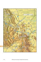
Pennsylvania Heartland 210 6 12 18 mi.Blain274850LandisburgOrbisoniaShade Gap75118Spring Run70Burnt CabinsPENNSYLVANIA522118123330255GettysburgMercersburg16SouthMountain11615Blue Ridge SummitLeft onto PA 16 Lincoln Way in McConnelsburgLeft onto PA 116Arrive Gettysburg via PA 116If time is short and you have the chance to try just one route through Pennsylvania,make it this one. This route features more varied terrain, sights,smells, and sounds than any other I’ve found yet. Go in early October whenthe trees are heavy with apples and the leaves are at their peak. It will bechilly when you begin, but you’ll soon forget about that, I assure you. Theroute begins by following Route 116 west out of Gettysburg, the ConfederateArmy’s trail of retreat from the Battle of Gettysburg. The retreating trainstretched out 17 miles along this road. At the time it was so bumpy that manyCHAPTER
22 Motorcycle Journeys Through the <strong>Appalachians</strong>Future apples in progress along Cold Springs Road near Gettysburg.of the wounded who were able walked the route rather than endure the hardshipof riding in wagons without springs. About five miles outside town,look for Cold Springs Road on your right.Cold Springs Road is a direct route to nowhere, but runs through somebeautiful orchard country. When the trees are loaded with fruit, the air is fragrantwith the smell of ripening apples. It isn’t the smoothest road; an easypace will be comfortable. You’re not in a hurry anyway, right? Just keepplugging away until you reach Route 233 north.A good portion of time spent on Route 233 will be through state forest land,first Michaux State Forest and then Tuscarora (dcnr.state.pa.us) Along theway, our path crosses that of the Appalachian Trail (nps.gov/appa/) for thefirst of many times throughout our travels. The trail, which stretches 2,144miles along Appalachian ridges from northern Maine to Georgia, is managedand maintained by a coalition of public and private interests and has oftenbeen called “a gift of nature Americans give themselves.” By earlyOctober, the foliage in central Pennsylvania has turned and your route islined with a fantastic assortment of fall colors. Your encounters with severalmajor thoroughfares that cross your path are blessedly uneventful. As youride under Interstate 81 and hear the traffic thunder overhead, you can’t helpbut wonder where all those people are going. They seem to be in such a hurryto get there, and it makes your 40 mph pace feel even more comfortable.As Route 233 passes through McCrea, the front of Blue Mountain loomsin front of you. It doesn’t look like there is much place for a road to go unlessit tunnels under the mountain, but it craftily follows a narrow valley throughCHAPTER
Pennsylvania Heartland 23Doubling Gap and into another small valley. Just ahead at Landisburg, youcan take a brief detour to Rice’s Bridge, a long covered bridge still in useover Sherman Creek. At the intersection with Route 850, make a right. Turnright on Kennedy Valley Road and follow it for a few tenths of a mile.There are more covered bridges in the United States than anywhere elsein the world, and more in Pennsylvania than any other state. At one time,there were more than 1,500, but that number has now dropped to 221. (Nextin line is Ohio, 140; Vermont, 99; and Indiana, 93. Iowa, the setting for thebest-seller The Bridges of Madison County, has 12.)Wooden bridges became popular in the mid-1800s with the developmentof a support system called the triangular truss. This allowed bridges of substantiallength to be built at a lower cost than ones using stone or iron. Theywere covered to shelter them from the elements and preserve their longevity.Many of the spans in Pennsylvania were built in the nineteenth century, withthose built near the end of the era still in use today, like the bridge here atLandisburg.If you are interested in finding more bridges, they are near the main routeand easy to find. Follow Route 850 west out of Landisburg until it joinsRoute 274 near Fort Robinson, then follow Route 274 to the left when itsplits from Route 850. All of these roads are wide open with gentle sweepingcurves and made for power road sofas like my Honda Gold Wing. However,any bike will enjoy tracing a smooth line through the curves, taking in ruralPennsylvania framed on either side by gentle ridges of the Alleghenies.Just past Centre, make a left turn on Couchtown Road, SR 3008. Thebridge along this route is to your left off the main traffic route. Make a righton SR 3005 and follow it over the covered bridge, then turn left on Red RockRoad, and make a left on Adams Road to the Enslow Bridge. This is a particularlypretty bridge, framed by trees. To the right of the bridge down thecreek is a bench perfect for a brief stop to soak in the atmosphere of thecountryside. Follow SR 3005 until it ends on SR 3006. Turn right on SR3006 and follow it through Blain, returning to Route 274 where you resumeyour westward trek. Two other bridges are close to the road along your way,though neither was open to traffic when I passed by. Along 274, look forbridges down Mount Pleasant Road and New Germantown Road, both onyour left.Backroads like these offer a lesson in never knowing what to expectaround the next bend. Just after entering Red Rock Road I rounded a cornerto find a young Amish boy aboard an old scooter trundling rapidly downhilltoward me. Surprised by the encounter, both of us shifted paths to avoid aCHAPTER
24 Motorcycle Journeys Through the <strong>Appalachians</strong>Orchards begin a new cycle of production along Cold Springs Road nearGettysburg.collision, but he still managed to give me a friendly wave as we passed. Nothalf a mile later, I rounded a bend to find a pickup truck parked dead smackin the middle of the road. More unusual was the sight of a pair of legs stickingout from under the truck across the road. No reason to call a tow truckwhen you can fix your vehicle on the spot.After New Germantown, the route enters the Tuscarora State Forestagain and Big Spring State Park. There are some quick switchbacks in thissection, so don’t let the relatively easy ascent fool you. Descending rapidly,you’ll meet wide-open Route 75. Turn left and follow it south to Path Valley.There isn’t much in the way of food service along the route, but if yourtiming puts you in the area of Spring Run, Pennsylvania near mealtime,make a point to stop by the Path Valley Family Restaurant (717-349-2900). Last time through the area, I dropped in on a Sunday afternoon wellpast the usual dinner hour. I squeezed the bike into the last remaining spot ofavailable pavement near the edge of the lot. Inside, the place was packed andmy only option was the seat at the counter nearest the cash register. It turnsout that was just the place to be.When I visit places like Path Valley, my favorite pasttime is enjoying theconversations around me about local people and events. Oh sure, somemight call that eavesdropping. I tend to think of it more as cultural study. Atthe end of the counter, the waitresses assembled their orders, and it was theCHAPTER
Pennsylvania Heartland 25perfect spot to engage in a little of that study. Most of the banter was theusual friendly chit-chat that helps pass time at the workplace.At some point I happened to hear one girl ask, “Honey, did you see your‘ex’ at the dance Friday night?”“Yeah, I sure did,” replied the other. “I was so surprised. I turned aroundand walked right smack into him. And I said to myself ‘Lord have mercy, Ididn’t know he was out of jail yet!’”Check please.When you’ve, er, done your time at the Path Valley, hop back on the bikefor the rest of this run. The restaurant is right at the intersection where you’llwant to turn. Head west on Route 641. This is a fun road that jumps over TuscaroraMountain with pretty vistas along the upper ridges. To the west, youcan see the Shade Mountain Gap. That’s where we’re headed. Route 641meets US Route 522 at Shade Gap. Follow Route 522 north to Orbisonia andthe East Broad Top Railroad (EBT) (ebtrr.com).The EBT began operating in 1872 to connect the isolated southwesterncoal and iron fields of the state with iron furnaces and the Pennsylvania Railroad.In the fall, the railroad hosts a weekend special when they draw outnearly their whole line of rolling stock. If you’re anywhere near the railroad,you’ll hear another tradition: the annual whistle salute. Not only does eachtrain have a distinctive whistle, each conductor has his own unique way ofusing it. This is perhaps the one safe time you can pass through town and revYour chance to “catch the first thing smokin’” at East Broadtop Railroad. ’Courseit only goes about a mile.CHAPTER
26 Motorcycle Journeys Through the <strong>Appalachians</strong>your straight pipes for all they’re worth without disturbing anyone. The EBToffers rides to passengers from June to October. If you’re interested in a ride,call ahead for an exact schedule.Another attraction located near the EBT is the Rockhill Trolley Museum(rockhilltrolley.org). This working museum has a collection of eighteen trolleycars and operates on a schedule in conjunction with the EBT. One car inparticular is made of Brazilian hardwoods that look as rich and beautiful asthe day the trolley started service.As I stood in front of the railroad taking pictures, a few folks stopped totake a look at the Gold Wing and comment on its enormous size and array ofgadgetry. One older gent and his wife stopped for a look. “Nice bike,” hesaid. “What is that, an Indian?” I guess it had been a while since he was partof the motorcycling scene. A few minutes later, an Amish family strolled by,mother and father and two young children in tow. Mother and the childrenpassed by with a polite nod, but the father paused just a moment and glancedat the bike. “Nice Wing,” he said and shot me a grin. Now do you suppose heis a closet . . . ? Naah.The return route passes by another covered bridge near Saint Mary’sCatholic Church near Shade Gap and then enters open farmland, much ofwhich is maintained by Amish farmers. You will often see them working theland with a harnessed mule team, or traversing the highway in their familiarblack buggies. This setting, quiet and isolated, seems more suited to theAmish than the much-hyped Pennsylvania Dutch country. In Penn Dutchcountry, the Amish are like a novelty attraction that you pay to view; herethey blend into the countryside. But I’ll bet that if one particular Amishfarmer had his way, his buggy would have a flat-six, reverse gear, and twowheels. Ahead of you is a long stretch of US 522 heading south towardMcConnelsburg. Like PA 274, your bike seems to find a naturally soothingtouring pace on this road. Perhaps it’s because you don’t pass through manysmall towns on this stretch. One in particular though rates a mention.Today when a developer builds a town, the marketing department willtwist itself into knots trying to find a name that strikes just the right chord.Reston, Virginia and Celebration, Florida come to mind. But out here in thebackwoods of Colonial Pennsylvania, marketing types were hard to find, sofolks just called things as they saw them. And that’s how Burnt Cabins,Pennsylvania (burntcabinsmill.com) came to be.What happened was simple. Settlers moving west in the 1740s had invadedland that was occupied by the Native Americans in that region. Whenthe settlers scared off the game, the chief complained to the Governor whoCHAPTER
Pennsylvania Heartland 27Downtown Gettysburg is great for strolling and browsing.had the illegal squatters packed up and their cabins torched. That’s the kindof direct action you could count on from a governor back in those days.US 522 intersects with PA 16 in McConnelsburg, and at this point, it’stime to head east for the return trip. On your way back via PA 16, you’ll passthrough several towns that, like Gettysburg, feature a large town square.Each square is filled with unique shops that you won’t find in any strip mall.These squares (sometimes referred to as “diamonds”) are actually the resultof the influence of Scots-Irish settlers who patterened them after the citiesand towns of Ulster.After passing through Waynesboro, you’ll soon run upon PA 116, theroute that began our journey. You’ll pass Ski Liberty (skiliberty.com) onyour right as you make the return trip. The hills around Ski Liberty won’timpress hard core winter sports enthusiasts. If you’re like me and you justwant to slide downhill on a tube and enjoy the benefit of riding a ski lift backuphill, it’s a great cold season venue.Before you know it, you’ve passed Cold Springs Road and are withinstriking distance of Gettysburg. You’ve had a good day’s ride, so park thebike and take one last stretch on Gettysburg’s town square before rustling upsome grub. Just be careful who you run into. You never know who’s just finisheddoing their time.CHAPTER