

dominguez
dominguez
dominguez
- No tags were found...

You also want an ePaper? Increase the reach of your titles
YUMPU automatically turns print PDFs into web optimized ePapers that Google loves.
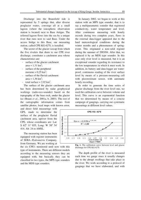
Substantial changes happened in the icecap of King Gorge, Insular Antarctica 89Discharge into the Bransfield side isrepresented by 5 springs that, after diverseproglacier routes, converge all at a smalllagoon (where the ionospheric observationstation is located) next to Base Artigas. Thereferred lagoon flows into the sea by a uniqueriver that runs next to said Base. Under theaccess bridge to this Base, our measuringstation, called CPE-KG-62ºS, is installed.The sector of the glacier icecap from whichthe five rivulets that drain to our CPE riverdischarge, constitutes a catchment area whosecharacteristics are:- surface of the glacier catchmentarea = 1,31 km 2 ;- surface of the peripheralmoraine = 0,25 km 2 ;- surface of the fluvial catchmentarea = 1,36 km 2 ;- total surface = 2,92 km 2 .The surface of the glacier catchment areahas been determined by radar geophysicalworkings (radio-eco-sounder) based on thetopography of the base rock, under the glacierice (Braun et al., 2001a, b, 2003). The rest ofthe cartographic information comes fromsatellite photos, local maps with known error,and direct field measurings withGPS, made to determine thesurface of the proglacier fluvialcatchment area, upriver from theCPE, whose coordinates are: Lat:S 62º 11' 035, Long: W 58º 54'414, Alt: 24 m AMSL.The measuring station has beenequipped with register instrumentsof SEBA Hydrometrie Company,from Germany. We are working atthe six CPE's monitored until now with thistype of instruments. There are different modelsaccording to the measuring sensors they areequipped with, but basically they can beclassified in two types, the MPS type soundersand the MDS type sounders.In January 2002, we began to work at thisstation with an MPS type sounder, that is tosay a multiparametric sounder that registeredconductivity, water temperature and level.After continuous measuring with hourlyrecords during two complete years, flaws inthe external data-logger appeared due to thehard meteorological conditions during thewinter months and a phenomenon of springevent.This originated a non-valid registerduring the summer of 2003/04. After that, wereplaced it by an MDS type sounder. In thiscase only river level is measured, but it is anexceptional sounder regarding its resistance tothe low temperatures in which it must work. Inaddition, its battery and data-logger are waterproof,continuous reading of the river surfacelevel by means of a pressure-measuring cellwith piezoresistant sensor, with automatichourly recording.In order to generate the time series ofglacier discharge from the river level one, weused the calibration curve between volume andlevel. This curve is an exponential functionthat we determined by means of a concisecampaign of gaugings, carrying out systematicmeasurings at different level values.Fig. 1. The calibration curve between level and glacierdischarge for CPE-KG-62ºSThe depth profile of the river is measuredeach time we gauge since it usually changesdue to the abrupt swellings that take place inthe river. We work according to a protocol ofgaugings that we have elaborated, and with