Belly River, Edmonton and Paskapoo Hydrogeology - Canadian ...
Belly River, Edmonton and Paskapoo Hydrogeology - Canadian ...
Belly River, Edmonton and Paskapoo Hydrogeology - Canadian ...
- No tags were found...

You also want an ePaper? Increase the reach of your titles
YUMPU automatically turns print PDFs into web optimized ePapers that Google loves.
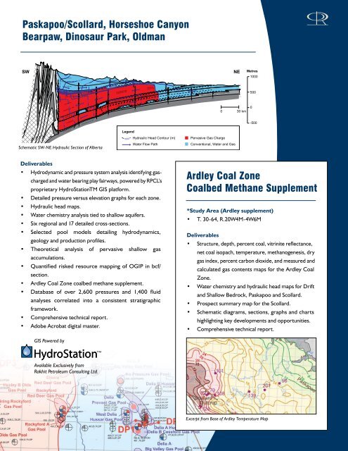
200300300400500600<strong>Paskapoo</strong>/Scollard, Horseshoe CanyonBearpaw, Dinosaur Park, OldmanSWB R A Z E A U F MC O A L S P U R F M1200G.R.1100( U P P E R )P A S K A P O O F M( L O W E R )C O A L S P U R - S C O L L A R D F M S( U P P E R )B R A Z E A U F M( M I D D L E )( L O W E R )T R A N S I T I O N A LS T R ATA1000G.R.900400C O L O R A D O G PSchematic SW-NE Hydraulic Section of AlbertaG.R.Ardley Coal900900G.R.800H O R S E S H O EC A N Y O N F MLethbridge CoalF O R E M O S T F MLegendG.R.O L D M A N F M500HorseshoeCanyon CoalMcKay CoalTaber Coal1000 Hydraulic Head Contour (m)Water Flow PathD.I.700B E A R P A W F MM I L K R I V E R A N D P A K O W K I F M SRES.RES.RES.NE Metres100050000 30 km-500Pervasive Gas ChargeConventional, Water <strong>and</strong> GasDeliverables• Hydrodynamic <strong>and</strong> pressure system analysis identifying gascharged<strong>and</strong> water bearing play fairways, powered by RPCL’sproprietary HydroStationTM GIS platform.• Detailed pressure versus elevation graphs for each zone.• Hydraulic head maps.• Water chemistry analysis tied to shallow aquifers.• Six regional <strong>and</strong> 17 detailed cross-sections.• Selected pool models detailing hydrodynamics,geology <strong>and</strong> production profiles.• Theoretical analysis of pervasive shallow gasaccumulations.• Quantified risked resource mapping of OGIP in bcf/section.• Ardley Coal Zone coalbed methane supplement.• Database of over 2,600 pressures <strong>and</strong> 1,400 fluidanalyses correlated into a consistent stratigraphicframework.• Comprehensive technical report.• Adobe Acrobat digital master.GIS Powered byArdley Coal ZoneCoalbed Methane Supplement*Study Area (Ardley supplement)• T. 30-64, R.20W4M-4W6MDeliverables• Structure, depth, percent coal, vitrinite reflectance,net coal isopach, temperature, methanogenesis, drygas index, percent carbon dioxide, <strong>and</strong> measured <strong>and</strong>calculated gas contents maps for the Ardley CoalZone.• Water chemistry <strong>and</strong> hydraulic head maps for Drift<strong>and</strong> Shallow Bedrock, <strong>Paskapoo</strong> <strong>and</strong> Scollard.• Prospect summary map for the Scollard.• Schematic diagrams, sections, graphs <strong>and</strong> chartshighlighting key developments <strong>and</strong> opportunities.• Comprehensive technical report.Available Exclusively fromRakhit Petroleum Consulting Ltd.Excerpt from Base of Ardley Temperature Map