100 Million Hectares 10 Per Cent of Canada 1 Generation - Forest ...
100 Million Hectares 10 Per Cent of Canada 1 Generation - Forest ...
100 Million Hectares 10 Per Cent of Canada 1 Generation - Forest ...
- No tags were found...

Create successful ePaper yourself
Turn your PDF publications into a flip-book with our unique Google optimized e-Paper software.
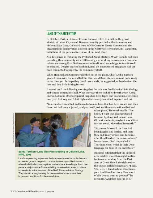
Land <strong>of</strong> the ancestorsIn October 2002, a 12-seater Cessna Caravan rolled to a halt on the gravelairstrip at Lutsel k’e, a small Dene community perched at the far eastern end<strong>of</strong> Great Slave Lake. On board were WWF-<strong>Canada</strong>’s Monte Hummel and theorganization’s conservation director in the Northwest Territories, Bill Carpenter,both there at the personal invitation <strong>of</strong> the local Chief.As a key player in initiating the Protected Areas Strategy, WWF-<strong>Canada</strong> had beenproviding the community with GIS training and working to overcome a commonreluctance among First Nations to record traditional knowledge for fear it wouldbe misused. Despite years <strong>of</strong> work in Lutsel k’e, no protected area plans had yetbeen committed to paper by the community itself.When Hummel and Carpenter climbed out <strong>of</strong> the plane, Chief Archie Catholicgreeted them with the news that the Elders and Band Council weren’t quite readyto see them yet. <strong>Per</strong>haps they could take a walk, he suggested, or head out on thelake and do a little fishing instead.It wasn’t until the following morning that the pair was finally invited into the logand-timbercommunity hall. What they saw there took their breath away. Alongone wall, dozens <strong>of</strong> topographical maps had been taped one to another, stretchingnearly 20 feet long and 8 feet high and intricately inscribed in pencil and ink.© J. Charlwood / Ducks Unlimited <strong>Canada</strong>“You could see lines that had been drawn and lines that had been erased and thenlines that had been adjusted, and you could just feel the conversations that hadtaken place,” Hummel recalls. “Youknow, ‘I want that place protectedbecause I got my first moose there.Oh, wait a minute, maybe it was a littlefurther north. Move that line north.’”Sahtu Territory Land Use Plan Meeting in Colville Lake,NWT, 2005Land use planning, a process that maps out areas for protection andeconomic growth, begins in community meetings – like this one –where individuals come together to share local knowledge. Land useplans, a major vehicle for establishing conservation areas, continueto contribute to the success <strong>of</strong> the NWT Protected Area Strategy.They remain a tangible way for communities to document theirhopes and ambitions for their own future.“So you could see all the lines hadbeen juggled and jostled, and thenthey had finally drawn one dark lineafter they’d had all the conversations,”he continues. “And they called itThaydene Nene, which is their Denelanguage for ‘land <strong>of</strong> the ancestors.’”Hummel estimated that the outlinedarea totalled more than eight millionhectares, extending from the EastArm <strong>of</strong> Great Slave Lake right out tothe Thelon Wildlife Sanctuary. “I said,‘OK, well, if I understand this, this isyour traditional territory. How much<strong>of</strong> this do you want to protect?’” herecounts. “And they said ‘all <strong>of</strong> it.’”WWF-<strong>Canada</strong> <strong><strong>10</strong>0</strong> <strong>Million</strong> <strong>Hectares</strong> | page 14