Important Natural Landscapes (Boffa Miskell, 2013)
Important Natural Landscapes (Boffa Miskell, 2013)
Important Natural Landscapes (Boffa Miskell, 2013)
- No tags were found...

Create successful ePaper yourself
Turn your PDF publications into a flip-book with our unique Google optimized e-Paper software.
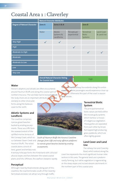
30Coastal Area 1 : Claverley<strong>Natural</strong> Character AttributesDegree of <strong>Natural</strong> Character Zone A Zones A & B Zone BWaterAbioticSystems &LandformsPerceptual/experientialTerrestrialBioticSystemsLand Cover& Land UseVery High HighModerate to High ModerateModerate to LowLowVery LowWaterOverall <strong>Natural</strong> Character Ratingfor Coastal AreaThe main north railway line extends along this entireHector’s dolphins and whales are often encounteredcoastline, where passengers would experience close-uparound Haumuri Bluffs and along this coastal part ofsea views. Otherwise this part of the coast is reason-northern Hurunui. The sub tidal marine ecosystems onably yremote.the rocky shore are an important attribute of this area,similarly to other shore platformsalong the KaikouraTerrestrial BioticSystemcoast to the north.The principal terrestrialbiotic values are held withinAbiotic Systems andthe incised gully systemsLandformwhich harbour a mosaicThe coastline comprisesof indigenous vegetation.narrow gravel beachesThese gullies are separatedbacked by eroding escarpments.These sea cliffs formfrom each other by broad,flat topped high producingthe seaward extent of thegrass paddocks, which areuplifted marine terraces ofoften lightly grazed.the Conway Coast, which occurbetween Dawn Creek and changes from cliffs and rocky offshore platformsSouth of Haumuri Bluffs the Hurunui CoastlineLand Cover and LandHaumuri Bluffs. The raised to narrow gravel beaches backed by erodingUsecoastal plains consist of escarpments.The railway line and Claverleyloess, gravel and tertiary rock.Road, which extend along theA tertiary hillscape forms the hinterland with colluvial/coast line represents the most significant human interventionin this area. The general land use is predomi-alluvial slopes and fans between the raised coastalplains and hills. Offshore, the seafloor steepens rapidly.nantly farming, but native vegetation is regeneratingon the steep slopes and incised stream catchments inPerceptualthe northern part of this coastal area.Although Claverley Road extends along part of thiscoastline, the road terminates south of the Claverleyfarmstead and does not attract any through-traffic.DRAFTFTFTHurunui District | <strong>2013</strong>High