Overview of the Groundwater Hydrology of the Rio Grande Basin
Overview of the Groundwater Hydrology of the Rio Grande Basin
Overview of the Groundwater Hydrology of the Rio Grande Basin

You also want an ePaper? Increase the reach of your titles
YUMPU automatically turns print PDFs into web optimized ePapers that Google loves.
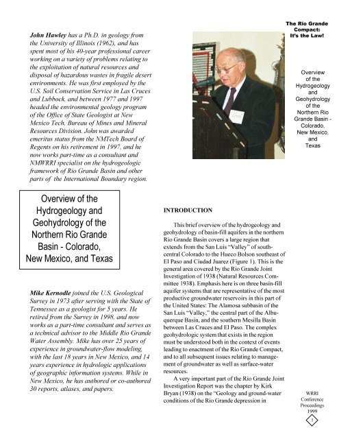
John Hawley has a Ph.D. in geology from<strong>the</strong> University <strong>of</strong> Illinois (1962), and hasspent most <strong>of</strong> his 40-year pr<strong>of</strong>essional careerworking on a variety <strong>of</strong> problems relating to<strong>the</strong> exploitation <strong>of</strong> natural resources anddisposal <strong>of</strong> hazardous wastes in fragile desertenvironments. He was first employed by <strong>the</strong>U.S. Soil Conservation Service in Las Crucesand Lubbock, and between 1977 and 1997headed <strong>the</strong> environmental geology program<strong>of</strong> <strong>the</strong> Office <strong>of</strong> State Geologist at NewMexico Tech, Bureau <strong>of</strong> Mines and MineralResources Division. John was awardedemeritus status from <strong>the</strong> NMTech Board <strong>of</strong>Regents on his retirement in 1997, and henow works part-time as a consultant andNMWRRI specialist on <strong>the</strong> hydrogeologicframework <strong>of</strong> <strong>Rio</strong> <strong>Grande</strong> <strong>Basin</strong> and o<strong>the</strong>rparts <strong>of</strong> <strong>the</strong> International Boundary region.The <strong>Rio</strong> <strong>Grande</strong>Compact:It’s <strong>the</strong> Law!<strong>Overview</strong><strong>of</strong> <strong>the</strong>HydrogeologyandGeohydrology<strong>of</strong> <strong>the</strong>Nor<strong>the</strong>rn <strong>Rio</strong><strong>Grande</strong> <strong>Basin</strong> -Colorado,New Mexico,andTexas<strong>Overview</strong> <strong>of</strong> <strong>the</strong>Hydrogeology andGeohydrology <strong>of</strong> <strong>the</strong>Nor<strong>the</strong>rn <strong>Rio</strong> <strong>Grande</strong><strong>Basin</strong> - Colorado,New Mexico, and TexasMike Kernodle joined <strong>the</strong> U.S. GeologicalSurvey in 1973 after serving with <strong>the</strong> State <strong>of</strong>Tennessee as a geologist for 5 years. Heretired from <strong>the</strong> Survey in 1998, and nowworks as a part-time consultant and serves asa technical advisor to <strong>the</strong> Middle <strong>Rio</strong> <strong>Grande</strong>Water Assembly. Mike has over 25 years <strong>of</strong>experience in groundwater-flow modeling,with <strong>the</strong> last 18 years in New Mexico, and 14years experience in hydrologic applications<strong>of</strong> geographic information systems. While inNew Mexico, he has authored or co-authored30 reports, atlases, and papers.INTRODUCTIONThis brief overview <strong>of</strong> <strong>the</strong> hydrogeology andgeohydrology <strong>of</strong> basin-fill aquifers in <strong>the</strong> nor<strong>the</strong>rn<strong>Rio</strong> <strong>Grande</strong> <strong>Basin</strong> covers a large region thatextends from <strong>the</strong> San Luis “Valley” <strong>of</strong> southcentralColorado to <strong>the</strong> Hueco Bolson sou<strong>the</strong>ast <strong>of</strong>El Paso and Ciudad Juarez (Figure 1). This is <strong>the</strong>general area covered by <strong>the</strong> <strong>Rio</strong> <strong>Grande</strong> JointInvestigation <strong>of</strong> 1938 (Natural Resources Committee1938). Emphasis here is on three basin-fillaquifer systems that are representative <strong>of</strong> <strong>the</strong> mostproductive groundwater reservoirs in this part <strong>of</strong><strong>the</strong> United States: The Alamosa subbasin <strong>of</strong> <strong>the</strong>San Luis “Valley,” <strong>the</strong> central part <strong>of</strong> <strong>the</strong> Albuquerque<strong>Basin</strong>, and <strong>the</strong> sou<strong>the</strong>rn Mesilla <strong>Basin</strong>between Las Cruces and El Paso. The complexgeohydrologic system that exists in <strong>the</strong> regionmust be understood both in <strong>the</strong> context <strong>of</strong> eventsleading to enactment <strong>of</strong> <strong>the</strong> <strong>Rio</strong> <strong>Grande</strong> Compact,and to all subsequent issues relating to management<strong>of</strong> groundwater as well as surface-waterresources.A very important part <strong>of</strong> <strong>the</strong> <strong>Rio</strong> <strong>Grande</strong> JointInvestigation Report was <strong>the</strong> chapter by KirkBryan (1938) on <strong>the</strong> “Geology and ground-waterconditions <strong>of</strong> <strong>the</strong> <strong>Rio</strong> <strong>Grande</strong> depression inWRRIConferenceProceedings19991
Figure 1. Index map showing major basins <strong>of</strong> <strong>the</strong> <strong>Rio</strong><strong>Grande</strong> rift and contiguous volcanic fields. Modifiedfrom Keller and Ca<strong>the</strong>r (1994). <strong>Basin</strong>s abbreviationsfrom north to south: Upper Arkansas (UA), San Luis(SL), Española (E), Santo Domingo (SD), Albuquerque(A), Socorro (Sc), La Jencia (la), San Augustin(SA), Jornada del Muerto (JM), Palomas (P), Tularosa(T), Mimbres (Mb), Mesilla (M), Los Muertos(LM), Hueco (H), and Salt (S). Cenozoic volcanicfields: San Juan (SJVF), Latir (LVF), Jemez (JVF),and Mogollon-Datil (MDVF).Colorado and New Mexico.” Bryan was <strong>the</strong> firstperson to recognize <strong>the</strong> hydrogeologic importance<strong>of</strong> a series <strong>of</strong> deep structural basins that are <strong>the</strong>defining components <strong>of</strong> <strong>the</strong> <strong>Rio</strong> <strong>Grande</strong> rift(RGR) tectonic province (Hawley, 1978; Chapinand Ca<strong>the</strong>r, 1994). This area includes parts <strong>of</strong> <strong>the</strong>Sou<strong>the</strong>rn Rocky Mountain, and <strong>Basin</strong> and Rangephysiographic provinces (Hawley 1986). From ahydrogeologic standpoint, Bryan’s (1938)important contributions include his observationsthat:1. The main body <strong>of</strong> sedimentary deposits <strong>of</strong><strong>the</strong> <strong>Rio</strong> <strong>Grande</strong> depression, from <strong>the</strong> north end<strong>of</strong> <strong>the</strong> San Luis valley to and beyond El Paso,is considered to be <strong>the</strong> same general age andto belong to <strong>the</strong> Santa Fe formation (p. 205).2. In general, <strong>the</strong> basins appear to have beenelongated into ovals and to be divisible intotwo major types ... basins with a throughflowingriver and basins with encloseddrainage (p. 205).3. [<strong>Rio</strong> <strong>Grande</strong> depression basins] differ fromo<strong>the</strong>r basins [in <strong>the</strong> <strong>Basin</strong> and Rangeprovince] principally in being strung likebeads on a string along <strong>the</strong> line <strong>of</strong> <strong>the</strong> <strong>Rio</strong><strong>Grande</strong> (p. 221).Bryan’s (1938) observations reflect not onlyhis own work in <strong>the</strong> nor<strong>the</strong>rn <strong>Rio</strong> <strong>Grande</strong> basinstarting in 1909, but also <strong>the</strong> ongoing studies <strong>of</strong>his students (e.g., Bryan and McCann 1937,1938; Denny 1940; Stearns 1953; Upson 1939;and Wright 1946) as well as previous hydrogeologicwork in <strong>the</strong> region by Lee (1907);Siebenthal (1910); Meinzer (1911); Meinzer andHare (1915); and Darton (1916). Reports by Lee(1907) and Siebenthal (1910), respectively, onwater resources <strong>of</strong> <strong>the</strong> <strong>Rio</strong> <strong>Grande</strong> and San Luis“Valleys” cover much <strong>of</strong> <strong>the</strong> region described inthis paper. Lee also presented an early conceptualmodel <strong>of</strong> <strong>the</strong> evolution <strong>of</strong> <strong>the</strong> <strong>Rio</strong> <strong>Grande</strong> fluvialsystem, and he emphasized <strong>the</strong> potential forbuilding a large dam at <strong>the</strong> Elephant Butte site forirrigation water storage. Based on observations inMexico and <strong>the</strong> American Southwest, Tolman(1909, 1937) also made a major contribution inbetter definition <strong>of</strong> <strong>the</strong> fundamental hydrogeologicdistinction between depositional systems inaggrading intermontane basins with topographicclosure (bolsons) and those that are open in terms<strong>of</strong> both surface and subsurface flow (semibolsons).Figures 2 and 3 illustrate <strong>the</strong> basic conceptualmodels, which were initially developed by Bryan(1938) and Tolman (1937), for hydrogeologicsystems and hydraulic regimes in groundwaterreservoirs that occur in Upper Cenozoic basin(bolson) fills <strong>of</strong> western North America. Figure 2is adapted from Bryan (1938, Figures 51 and 52),and it clearly demonstrates that a basicunderstanding <strong>of</strong> <strong>the</strong> integrated groundwater andsurface-water flow system in basins <strong>of</strong> <strong>the</strong> “<strong>Rio</strong><strong>Grande</strong> depression” already existed at <strong>the</strong> time(1937-1939) <strong>of</strong> final acceptance <strong>of</strong> <strong>Rio</strong> <strong>Grande</strong>Compact provisions.The <strong>Rio</strong> <strong>Grande</strong>Compact:It’s <strong>the</strong> Law!<strong>Overview</strong><strong>of</strong> <strong>the</strong>HydrogeologyandGeohydrology<strong>of</strong> <strong>the</strong>Nor<strong>the</strong>rn <strong>Rio</strong><strong>Grande</strong> <strong>Basin</strong> -Colorado,New Mexico,andTexasWRRIConferenceProceedings19992
The <strong>Rio</strong> <strong>Grande</strong>Compact:It’s <strong>the</strong> Law!<strong>Overview</strong><strong>of</strong> <strong>the</strong>HydrogeologyandGeohydrology<strong>of</strong> <strong>the</strong>Nor<strong>the</strong>rn <strong>Rio</strong><strong>Grande</strong> <strong>Basin</strong> -Colorado,New Mexico,andTexasFigure 2. Kirk Bryan’s conceptual models <strong>of</strong> hydraulic regimes in groundwater reservoirs <strong>of</strong> <strong>the</strong> “<strong>Rio</strong> <strong>Grande</strong>depression.” Modified from Bryan (1938, Figures 51 and 52).WRRIConferenceProceedings19993
Figure 3. Conceptual hydrogeologic model showingundrained basins, partly drained basins, drained basins,and regional sinks (modified from Eakin et al. 1976;Hibbs et al. 1998). Phreatic playas are restricted toundrained and partly drained basins; and vadoseconditions exist in “dry playa” areas.Figure 3 illustrates <strong>the</strong> Bryan-Tolman conceptualmodel in a more general hydrogeologicsense for <strong>the</strong> entire <strong>Basin</strong> and Range province,and it incorporates subsequent work in <strong>the</strong> Great<strong>Basin</strong> section (e.g., Mifflin 1968, 1988; Eakin etal. 1976), and in <strong>the</strong> Trans-Pecos Texas andChihuahua bolson region (Hibbs et al. 1998). Thetopographic terms closed and open are here usedonly in reference to <strong>the</strong> surface flow into, through,and from intermontane basins, whereas <strong>the</strong> termsundrained, partly drained, and drained designateclasses <strong>of</strong> groundwater flow involving intrabasinand/or interbasin movement. Phreatic and vadose,respectively, indicate saturatedand unsaturated subsurfaceconditions. Phreatic playas(with springs and seeps) arerestricted to floors <strong>of</strong> closedbasins (bolsons) that are undrainedor partly drained, andvadose playas occur in bothclosed and open, drained basins.In <strong>the</strong> <strong>Rio</strong> <strong>Grande</strong> rift studyregion, as well as in most o<strong>the</strong>rdesert basins <strong>of</strong> western NorthAmerica, <strong>the</strong> intermediate basinclass referred to as partlydrained is probably <strong>the</strong> majorgroundwater-flow regime. Fewintermontane basins (bolsonsand semibolsons) are truly undrained in terms<strong>of</strong> groundwater discharge, whe<strong>the</strong>r or not <strong>the</strong>yare closed or open in terms <strong>of</strong> surface flow.Under predevelopment conditions, groundwaterdischarge in <strong>the</strong> region occurred mainlythrough subsurface leakage from one basinsystem into ano<strong>the</strong>r, discharge into <strong>the</strong> gainingreaches <strong>of</strong> perennial or intermittent streams,discharge from springs, or by evapotranspirationfrom phreatic playas and cienegas(valley-floor wetlands). Most recharge tobasin-fill aquifers occurs by two mechanisms,(1) “mountain front,” where some precipitationfalling on bedrock highlands contributesto <strong>the</strong> groundwater reservoir along basinmargins (Figure 4); and (2) “tributary,” where<strong>the</strong> reservoir is replenished and along losingreaches <strong>of</strong> larger intrabasin streams (Hearneand Dewey 1988; Anderholm 1994; Kernodle1992; Wasiolek 1995). The upland networks<strong>of</strong> major stream valleys in <strong>the</strong> Sangre deCristo, San Juan, and Jemez Mountains <strong>of</strong>sou<strong>the</strong>rn Colorado and nor<strong>the</strong>rn New Mexicoare <strong>the</strong> primary source areas for recharge <strong>of</strong>basin-fill aquifers in <strong>the</strong> RGR region. Secondarycontributors to <strong>the</strong>se groundwater reservoirsare <strong>the</strong> few high and massive mountainranges that form isolated highlands borderingindividual basin units. Recharge estimates inthis paper are based on <strong>the</strong> assumption that (1)less than 5% <strong>of</strong> average annual precipitationcontributes to recharge, and (2) this contributionis distributed very unevenly over higherwatersheds and in major stream valleys.Figure 4. Two-dimensional conceptual model <strong>of</strong> a groundwater rechargesystem in a <strong>Basin</strong> and Range by hydrogeologic setting (from Wasiolek 1995,modified from Feth 1964, and Mifflin 1968).The <strong>Rio</strong> <strong>Grande</strong>Compact:It’s <strong>the</strong> Law!<strong>Overview</strong><strong>of</strong> <strong>the</strong>HydrogeologyandGeohydrology<strong>of</strong> <strong>the</strong>Nor<strong>the</strong>rn <strong>Rio</strong><strong>Grande</strong> <strong>Basin</strong> -Colorado,New Mexico,andTexasWRRIConferenceProceedings19994
Journal <strong>of</strong> Uncertain Systems, Vol.6, No.4, pp.299-307, 2012 303Pro<strong>of</strong>: If Sa[ξ] = 0, <strong>the</strong>n E[|(ξ − e) − |] = 0. By <strong>the</strong> definition <strong>of</strong> expected value, we haveE[|(ξ − e) − |] =∫ +∞0M{|(ξ − e) − | ≥ r}dr,which implies M{|(ξ − e) − | ≥ r} = 0 for any r > 0. Fur<strong>the</strong>r, it is obtained thatM{|(ξ − e) − | = 0} = 1, (8)which implies ξ − e = (ξ − e) + + (ξ − e) − = (ξ − e) + almost everywhere. As a consequence, we have∫ +∞0M{(ξ − e) + ≥ r}dr = E[(ξ − e) + ] = E[ξ − e] = 0.This indicates that M{(ξ − e) + ≥ r} = 0 for any r > 0. Considering <strong>the</strong> self-duality <strong>of</strong> uncertain measure, wehaveM{(ξ − e) + = 0} = 1. (9)If follows from equations (8) and (9) that M{ξ − e = 0} = 1, i.e., M{ξ = e} = 1. Conversely, if M{ξ = e} = 1,<strong>the</strong>n we have M{|ξ − e| = 0} = 1 and M{|ξ − e| ≥ r} = 0 for any real number r > 0, which implies thatE[|ξ − e|] = 0. Fur<strong>the</strong>r, it follows from Theorem 2 that Sa[ξ] = 0. The pro<strong>of</strong> is complete.4 Mean Semi-absolute Deviation ModelsIn this section, we establish new portfolio optimization models in uncertain environment by employing <strong>the</strong>semi-absolute deviation <strong>of</strong> <strong>the</strong> portfolio as <strong>the</strong> measure <strong>of</strong> risk. Let ξ i (i = 1, 2, . . . , n) be <strong>the</strong> uncertain return<strong>of</strong> <strong>the</strong> ith security, and x i be <strong>the</strong> proportion <strong>of</strong> total amount <strong>of</strong> funds invested in security i. By uncertainarithmetic, <strong>the</strong> total return <strong>of</strong> <strong>the</strong> portfolio is ξ 1 x 1 + ξ 2 x 2 + · · · + ξ n x n which is also an uncertain variable.This means that <strong>the</strong> portfolio is risky. If an investor wants to maximize <strong>the</strong> expected return at <strong>the</strong> given risklevel, <strong>the</strong>n it can express in a single-objective non-linear programming model as follows,⎧⎪⎨⎪⎩maximize E[ξ 1 x 1 + ξ 2 x 2 + · · · + ξ n x n ]subject to: Sa[ξ 1 x 1 + ξ 2 x 2 + · · · + ξ n x n ] ≤ d,x 1 + x 2 + · · · + x n = 1,x i ≥ 0, i = 1, 2, . . . , n,where d denotes <strong>the</strong> maximum risk level <strong>the</strong> investors can tolerate. The constraints ensure that all <strong>the</strong> capitalwill be invested to n securities and short sales are not allowed. It is worth pointing out that <strong>the</strong> proposedmodel mainly deal with <strong>the</strong> case with asymmetrical return.When an investor wants to minimize <strong>the</strong> risk <strong>of</strong> investment with an acceptable expected return level, <strong>the</strong>ma<strong>the</strong>matical formulation <strong>of</strong> <strong>the</strong> problem is given as follows,⎧⎪⎨⎪⎩minimize Sa[ξ 1 x 1 + ξ 2 x 2 + · · · + ξ n x n ]subject to: E[ξ 1 x 1 + ξ 2 x 2 + · · · + ξ n x n ] ≥ r,x 1 + x 2 + · · · + x n = 1,x i ≥ 0, i = 1, 2, . . . , n,where r is <strong>the</strong> minimum expected return level accepted by <strong>the</strong> investor.A risk-averse investor always wants to maximize <strong>the</strong> return and minimize <strong>the</strong> risk <strong>of</strong> <strong>the</strong> portfolio. However,<strong>the</strong>se two objects are inconsistent. To determine an optimal portfolio with a given degree <strong>of</strong> risk aversion, weformalize <strong>the</strong> following optimization model,⎧⎨⎩maximize E[ξ 1 x 1 + ξ 2 x 2 + · · · + ξ n x n ] − ϕ · Sa[ξ 1 x 1 + ξ 2 x 2 + · · · + ξ n x n ]subject to: x 1 + x 2 + · · · + x n = 1,x i ≥ 0, i = 1, 2, . . . , n,(10)(11)(12)
The <strong>Rio</strong> <strong>Grande</strong>Compact:It’s <strong>the</strong> Law!Table 1. Summary <strong>of</strong> lith<strong>of</strong>acies-assemblage depositional settings and dominant textures for Santa Fe Group(1-10) and Post-Santa Fe (a,b,c) basin and valley fills (modified from Hawley and Haase 1992, Table III-2)Lith<strong>of</strong>acies Dominant depositional settings and process Dominant textural classes1 <strong>Basin</strong>-floor fluvial plain Sand and pebble gravel, lenses <strong>of</strong> silty clay2 <strong>Basin</strong>-floor fluvial, locally eolian Sand; lenses <strong>of</strong> pebble sand, and silty clay3 <strong>Basin</strong>-floor, fluvial-overbank, fluvial-deltaic and playa-lake; Interbedded sand and silty clay; lenses <strong>of</strong> pebbly sandeolian4 Eolian, basin-floor alluvial Sand and sandstone; lenses <strong>of</strong> silty sand to clay5 Distal to medial piedmont-slope, alluvial fan Gravel, sand, silt, and clay; common loamy (sandsilt-clay)5a Distal to medial piedmont-slope, alluvial fan; associated Sand and gravel; lenses <strong>of</strong> gravelly, loamy sand tosandy loamwith large watersheds; alluvial-fan distributary-channelprimary, sheet-flood and debris-flow, secondary<strong>Overview</strong><strong>of</strong> <strong>the</strong>HydrogeologyandGeohydrology<strong>of</strong> <strong>the</strong>Nor<strong>the</strong>rn <strong>Rio</strong><strong>Grande</strong> <strong>Basin</strong> -Colorado,New Mexico,andTexas5b Distal to medial piedmont-slope, alluvial-fan; associated Gravelly, loamy sand to sandy loam; lenses <strong>of</strong> sand,gravel, and silty claywith small steep watersheds; debris-flow sheet-flood,and distributary-channel6 Proximal to medial piedmont-slope, alluvial-fan Coarse gravelly, loamy sand and sandy loam; lenses<strong>of</strong> sand and cobble to boulder gravel6a Like 5a Sand and gravel; lenses <strong>of</strong> gravelly to non-gravelly,loamy sand to sandy loam6b Like 5b Gravelly, loamy sand to sandy loam; lenses <strong>of</strong> sand,gravel, and silty clay7 Like 5 Partly indurated 58 Like 6 Partly indurated 69 <strong>Basin</strong>-floor–alluvial flat, playa, lake, and fluvial- Silty clay interbedded with sand, silty sand and claylacustrine; distal-piedmont alluvial10 Like 9, with evaporite processes (paleophreatic) Partly indurated 9, with gypsiferous and alkaliimpregnatedzonesa River-valley, fluvial Sand, gravel, silt and claya1 Basal channel Pebble to cobble gravel and sand (like 1)a2 Braided plain, channel Sand and pebbly sand (like 2)a3 Overbank, meander- belt oxbow Silty clay, clay, and sand (like 3)b Arroyo channel, and valley-border alluvial-fan Sand, gravel, silt, and clay (like 5)c <strong>Basin</strong> floor, alluvial flat, cienega, playa, and fluvial-fan to Silty clay, clay and sand (like 3,5, and 9)lacustrine plainWRRIConferenceProceedings19997
Table 2. Summary <strong>of</strong> properties that influence groundwater production potential <strong>of</strong> Santa Fe Group lith<strong>of</strong>aciesassemblages (modified from Haase and Lozinsky 1992) [>, greater than; 1.5 Elongate to planar > 300 High High High2 High to moderate > 1.5 Elongate to planar > 300 High to moderate High to moderate High to moderate3 Moderate > 1.5 Planar 150 to 300 Moderate to high Moderate Moderate4 Moderate to low* > 1.5 Planar to elongate 30 to 150 Moderate to high Moderate Moderate5 Moderate to high 0.3 to 1.5 Elongate to lobate 30 to 150 Moderate Moderate to low Moderate to low5a High to moderate 0.3 to 1.5 Elongate to lobate 30 to 150 Moderate Moderate Moderate5b Moderate 0.3 to 1.5 Lobate 30 to 150 Moderate to low Moderate to low Moderate to low6 Moderate to low 0.3 to 1.5 Lobate to elongate 30 to 150 Moderate to low Moderate to low Low to moderate6a Moderate 0.3 to 1.5 Lobate to elongate 30 to 150 Moderate Moderate to low Moderate to low6b Moderate to low 0.3 to 1.5 Lobate < 30 Low to moderate Low to moderate Low7 Moderate * 0.3 to 1.5 Elongate to lobate 30 to 150 Moderate Low Low8 Moderate to low * > 1.5 Lobate < 30 Low to moderate Low Low9 Low > 3.0 Planar > 150 Low Very low Very low10 Low* > 3.0 Planar > 150 Low Very low Very low1High >2; moderate 0.5-2; low < 0.52Elongate (length to width ratios > 5); planar (length to width ratios 1-5); lobate (asymmetrical or incomplete planar beds).3Measure <strong>of</strong> <strong>the</strong> lateral extent <strong>of</strong> an individual bed <strong>of</strong> given thickness and configuration.4Estimate <strong>of</strong> <strong>the</strong> ease with which groundwater can flow between individual beds within a particular lith<strong>of</strong>acies. Generally, high sand + gravel/silt + clayratios, thick beds, and high bedding continuity favor high bedding connectivity. All o<strong>the</strong>r parameters being held equal, <strong>the</strong> greater <strong>the</strong> beddingconnectivity, <strong>the</strong> greater <strong>the</strong> groundwater production potential <strong>of</strong> a sedimentary unit (Hawley and Haase 1992, VI).5High 10 to 30 m/day; moderate, 1 to 10 m/day; low, < 1 m/day; very low, < 0.1 m/day.The <strong>Rio</strong> <strong>Grande</strong>Compact:It’s <strong>the</strong> Law!<strong>Overview</strong><strong>of</strong> <strong>the</strong>HydrogeologyandGeohydrology<strong>of</strong> <strong>the</strong>Nor<strong>the</strong>rn <strong>Rio</strong><strong>Grande</strong> <strong>Basin</strong> -Colorado,New Mexico,andTexasWRRIConferenceProceedings19998
Table 3. Summary <strong>of</strong> properties that influence groundwater production potential <strong>of</strong> Post - Santa Fe Group lith<strong>of</strong>aciesassemblages [>, greater than; 1.5 Elongate to planar > 300 High to moderate High to moderate High to moderatea1 High > 1.5 Elongate to planar > 300 High High Higha2 High to moderate > 1.5 Planar to elongate 150 to 300 Moderate to high Moderate Moderatea3 Moderate to low > 1.5 Planar to elongate 30 to 150 Moderate to high Moderate to low Moderate to lowb Moderate to low 0.3 to 1.5 Elongate to lobate 2; moderate 0.5-2; low < 0.52Elongate (length to width ratios > 5); planar (length to width ratios 1-5); lobate (asymmetrical or incomplete planar beds).3Measure <strong>of</strong> <strong>the</strong> lateral extent <strong>of</strong> an individual bed <strong>of</strong> given thickness and configuration.4Estimate <strong>of</strong> <strong>the</strong> ease with which groundwater can flow between individual beds within a particular lith<strong>of</strong>acies. Generally, high sand + gravel/silt + clayratios, thick beds, and high bedding continuity favor high bedding connectivity. All o<strong>the</strong>r parameters being held equal, <strong>the</strong> greater <strong>the</strong> beddingconnectivity, <strong>the</strong> greater <strong>the</strong> groundwater production potential <strong>of</strong> a sedimentary unit (Hawley and Haase 1992, VI).5High 10 to 30 m/day; moderate, 1 to 10 m/day; low, < 1 m/day; very low, < 0.1 m/day.The <strong>Rio</strong> <strong>Grande</strong>Compact:It’s <strong>the</strong> Law!<strong>Overview</strong><strong>of</strong> <strong>the</strong>HydrogeologyandGeohydrology<strong>of</strong> <strong>the</strong>Nor<strong>the</strong>rn <strong>Rio</strong><strong>Grande</strong> <strong>Basin</strong> -Colorado,New Mexico,andTexasWRRIConferenceProceedings19999
Hydrostratigraphic UnitsMost intermontane-basin fills in <strong>the</strong> NewMexico region have been subdivided into twomajor lithostratigraphic units (Figure 6), <strong>the</strong>Santa Fe Group in <strong>Rio</strong> <strong>Grande</strong> rift basins (e.g.,Hawley 1978; Chapin and Ca<strong>the</strong>r 1994) and <strong>the</strong>Gila Group in basins <strong>of</strong> <strong>the</strong> Mexican Highlandand Datil-Mogollon sections to <strong>the</strong> west (Hawleyet al. 2000). In addition, a clear distinction hasrarely been made between deposits simply classedas “bolson” or “basin” fill and contiguous (formaland informal) subdivisions <strong>of</strong> <strong>the</strong> Santa Fe andGila groups. As a first step in organizing availableinformation on basin fill stratigraphy that hasa close relationship with aquifer characteristics, aprovisional hydrostratigraphic classificationsystem (Seaber 1988) has been developed. Itfollows guidelines used successfully in <strong>the</strong>Albuquerque and Mesilla basins (Hawley andLozinsky 1992; Hawley et al. 1995) and inadjacent “Southwest Alluvial <strong>Basin</strong>s” as definedby Wilkins (1986, 1998).Hydrostratigraphic units defined in <strong>the</strong> RGRregion are mappable bodies <strong>of</strong> basin fill andvalley fill that are grouped on <strong>the</strong> basis <strong>of</strong> originand position in both lithostratigraphic and chronostratigraphicsequences. The informal upper,middle, and lower Santa Fe hydrostratigraphicunits (HSUs: USF, MSF, LSF) comprise <strong>the</strong>major basin-fill aquifer zones, and <strong>the</strong>y correspondroughly to <strong>the</strong> (formal and informal) upper,middle, and lower lithostratigraphic subdivisions<strong>of</strong> <strong>the</strong> Santa Fe Groups used in local and regionalgeologic mapping (Figure 6). Dominant lith<strong>of</strong>aciesassemblages in <strong>the</strong> upper Santa Fe HSUare LFAs 1-3, 5 and 6. The middle Santa FeHSU is characterized by LFAs 3, 4, 7-9, and <strong>the</strong>lower Santa Fe commonly comprises LFAs 9, 7-10. <strong>Basin</strong>-floor facies assemblages 3 and 9 arecommonly present throughout <strong>the</strong> Santa Fe Groupsection in closed-basin (bolson) areas.The o<strong>the</strong>r major hydrostratigraphic unitscomprise channel and floodplain deposits <strong>of</strong> <strong>the</strong><strong>Rio</strong> <strong>Grande</strong> (RG) and its major tributaries such as<strong>the</strong> <strong>Rio</strong> Chama and <strong>Rio</strong> Puerco. These valley fills<strong>of</strong> Late Quaternary age form <strong>the</strong> upper part <strong>of</strong><strong>the</strong> region’s most productive shallow-aquifersystem (LFAa). Surficial lake and playa deposits,fills <strong>of</strong> larger arroyo valleys, and piedmont-slopealluvium are primarily in <strong>the</strong> vadose zone.However, <strong>the</strong>y locally form important groundwaterdischarge and recharge sites. Historicalphreatic conditions exist, or have recently existed,in a few playa remnants <strong>of</strong> large pluvial lakes <strong>of</strong>Late Quaternary age (Hawley 1993). Notableexamples are “gypsum or alkali flats” in <strong>the</strong>Tularosa, Jornada del Muerto and Los Muertosbasins, which are contiguous to, but outside <strong>the</strong>area discussed in this paper.Bedrock and Structural Boundary ComponentsStructural and bedrock features that influenceaquifer composition and behavior include basinboundarymountain uplifts, bedrock units beneath<strong>the</strong> basin-fill, fault zones and flexures within andat <strong>the</strong> edges <strong>of</strong> basins, and igneous-intrusive andextrusive rocks that penetrate or are interbeddedwith basin fill. Tectonic evolution <strong>of</strong> <strong>the</strong> faultblockbasins and ranges <strong>of</strong> <strong>the</strong> study area (manywith a half-graben structure and accommodationzoneterminations) has had a pr<strong>of</strong>ound effect on<strong>the</strong> distribution <strong>of</strong> lith<strong>of</strong>acies assemblages and <strong>the</strong>timing and style <strong>of</strong> emplacement <strong>of</strong> all majorhydrostratigraphic units (Figs. 5 and 6). Discussion<strong>of</strong> this topic is beyond <strong>the</strong> scope <strong>of</strong> thispaper, however, <strong>the</strong> reader is referred to pertinentreviews in Collins and Raney (1991), Keller andCa<strong>the</strong>r (1994), Hawley and o<strong>the</strong>rs (1995), Bauerand o<strong>the</strong>rs (1995), G<strong>of</strong>f and o<strong>the</strong>rs (1996), Mackand o<strong>the</strong>rs (1997, 1998), Faulds and Varga(1998), Haneberg (1998), and Pazzaglia andLucas (1999).HYDROGEOLOGIC FRAMEWORK OFREPRESENTATIVE RGR BASINSFigures 7, 8, and 9 are schematic hydrogeologiccross-sections that illustrate <strong>the</strong> basicstructural framework and distribution patterns <strong>of</strong>major hydrostratigraphic units, respectively, in <strong>the</strong>central parts <strong>of</strong> <strong>the</strong> San Luis, Albuquerque, andMesilla basins <strong>of</strong> <strong>the</strong> <strong>Rio</strong> <strong>Grande</strong> rift structuralprovince. In addition to parts <strong>of</strong> <strong>the</strong> Española<strong>Basin</strong> near Los Alamos and <strong>the</strong> Hueco Bolsonnear El Paso (Purtymun 1995; Cliett and Hawley1996), <strong>the</strong>se are <strong>the</strong> only areas where high-qualityborehole geophysical and sample logs, and avariety <strong>of</strong> o<strong>the</strong>r geophysical and geochemicalsurvey data are available. It is important to notethat much <strong>of</strong> this information is related to deep-The <strong>Rio</strong> <strong>Grande</strong>Compact:It’s <strong>the</strong> Law!<strong>Overview</strong><strong>of</strong> <strong>the</strong>HydrogeologyandGeohydrology<strong>of</strong> <strong>the</strong>Nor<strong>the</strong>rn <strong>Rio</strong><strong>Grande</strong> <strong>Basin</strong> -Colorado,New Mexico,andTexasWRRIConferenceProceedings199910
The <strong>Rio</strong> <strong>Grande</strong>Compact:It’s <strong>the</strong> Law!<strong>Overview</strong><strong>of</strong> <strong>the</strong>HydrogeologyandGeohydrology<strong>of</strong> <strong>the</strong>Nor<strong>the</strong>rn <strong>Rio</strong><strong>Grande</strong> <strong>Basin</strong> -Colorado,New Mexico,andTexasFigure 6. Regional summary and correlation <strong>of</strong> major lithostratigraphic and basin-fill hydrostratigraphic units(HSUs) in <strong>the</strong> <strong>Rio</strong> <strong>Grande</strong> rift region. Volcanic-rock symbols: Qb-Quaternary basalt; Tb and Tr- Tertiary maficand silicic volcanics, respectively; Tv-primarily intermediate and silicic volcanics.WRRIConferenceProceedings199911
asin exploration for hydrocarbon and geo<strong>the</strong>rmalresources. Geologic mapping and geochronologicstudies throughout <strong>the</strong> RGR region demonstrate<strong>the</strong> continuity and correlation <strong>of</strong> major lithostrati-The <strong>Rio</strong> <strong>Grande</strong>Compact:graphic and informal hydrostratigraphic units It’s <strong>the</strong> Law!(Figure 6) that were originally recognized by KirkBryan (cf. Hawley 1978; Chapin and Ca<strong>the</strong>r1994).<strong>Overview</strong><strong>of</strong> <strong>the</strong>HydrogeologyandGeohydrology<strong>of</strong> <strong>the</strong>Nor<strong>the</strong>rn <strong>Rio</strong><strong>Grande</strong> <strong>Basin</strong> -Colorado,New Mexico,andTexasFigure 7. Schematic hydrogeologic cross section <strong>of</strong> <strong>the</strong> Alamosa subbasin <strong>of</strong> <strong>the</strong> San Luis structural basin near <strong>the</strong>Alamosa-Saguache County Line. Modified from Brister and Gries (1994, Figure 3). The base <strong>of</strong> <strong>the</strong> section is <strong>the</strong>top <strong>of</strong> an ash-flow tuff unit <strong>of</strong> late Oligocene age.WRRIConferenceProceedings199912
Figure 7 is a hydrogeologic section, adaptedfrom Brister and Gries, 1994, that documents <strong>the</strong>half-graben structure and relatively narrow width<strong>of</strong> <strong>the</strong> Alamosa subbasin <strong>of</strong> <strong>the</strong> San Luis Valley in<strong>the</strong> area west <strong>of</strong> Great Sand Dunes NationalMonument. It is <strong>the</strong> only RGR basin discussed inthis paper that is both topographically closed andinternally drained (cf. Figures 2 and 3). Bristerand Gries (1994) include <strong>the</strong> Alamosa Formation<strong>of</strong> Siebenthal (1910) in <strong>the</strong>ir Upper Santa FeGroup lithostratigraphic unit, and <strong>the</strong>ir “Lower”Santa Fe Group correlates with <strong>the</strong> Santa FeFormation <strong>of</strong> previous workers (Powell 1958;Emery et al. 1971). In this paper <strong>the</strong> gravellyupper part <strong>of</strong> <strong>the</strong> “lower” Santa Fe section isinformally defined as <strong>the</strong> middle Santa Fe HSU,which comprises two major facies groups,piedmont slope (MSF1 and 3) and basin floor(MSF2). Note that <strong>the</strong> Hearne and Dewey (1988)model <strong>of</strong> <strong>the</strong> San Luis <strong>Basin</strong> only covers <strong>the</strong>upper 3,200 feet <strong>of</strong> saturated basin fill, and it,<strong>the</strong>refore, is primarily restricted to <strong>the</strong> upper andmiddle Santa Fe HSUs.The Brister-Gries study utilized informationfrom cross-basin seismic-survey lines as well assample and geophysical logs from deep boreholes.As shown in Figure 7, <strong>the</strong> Santa Fe Group islocally as much as 9,500 ft. thick near <strong>the</strong> easternedge <strong>of</strong> <strong>the</strong> half-graben (hanging-wall) block. Thisstudy also demonstrates that Santa Fe Groupbasin fill is relatively thin in <strong>the</strong> western half <strong>of</strong><strong>the</strong> Alamosa subbasin, and that most basindeposits heret<strong>of</strong>ore correlated with <strong>the</strong> Santa FeGroup by hydrogeologists are actually Lower toMiddle Cenozoic sedimentary and volcanic rocksthat predate RGR development. This suggests thatmodel estimates <strong>of</strong> “Santa Fe Formation” hydraulicconductivity made by Hearne and Dewey(1988) may be much too high in large parts <strong>of</strong> <strong>the</strong>western Alamosa subbasin (cf. Table 4).The east-central part <strong>of</strong> <strong>the</strong> Albuquerque<strong>Basin</strong> includes <strong>the</strong> deepest known segment <strong>of</strong> <strong>the</strong>RGR structural depression. <strong>Basin</strong> fill in <strong>the</strong> areanear Isleta Pueblo locally exceeds 14,500 ft.(Lozinsky 1994; Hawley et al. 1995, Fig. 3).Figure 8 is a schematic hydrogeologic section <strong>of</strong>The <strong>Rio</strong> <strong>Grande</strong>Compact:It’s <strong>the</strong> Law!<strong>Overview</strong><strong>of</strong> <strong>the</strong>HydrogeologyandGeohydrology<strong>of</strong> <strong>the</strong>Nor<strong>the</strong>rn <strong>Rio</strong><strong>Grande</strong> <strong>Basin</strong> -Colorado,New Mexico,andTexasFigure 8. Schematic hydrogeologic cross section <strong>of</strong> <strong>the</strong> nor<strong>the</strong>rn Albuquerque <strong>Basin</strong> about 3 miles south <strong>of</strong><strong>the</strong> Bernalillo-Sandoval County Line. Modified from Hawley and o<strong>the</strong>rs (1995, Fig. 4).WRRIConferenceProceedings199913
<strong>the</strong> central basin area between Albuquerque and<strong>Rio</strong> Rancho. Its base is at mean sea level, whichis about 3,200 feet below <strong>the</strong> active layers <strong>of</strong> <strong>the</strong>groundwater-flow model discussed in <strong>the</strong> concludingsection <strong>of</strong> this report. As in <strong>the</strong> Alamosasubbasin, <strong>the</strong> major aquifer system utilized in <strong>the</strong>Albuquerque-<strong>Rio</strong> Rancho metropolitan areacomprises <strong>the</strong> upper and middle Santa Fe HydrostratigraphicUnits (HSUs: USF and MSF) asoriginally defined in Hawley and Haase (1992)and Hawley and o<strong>the</strong>rs (1995). However, <strong>the</strong>Albuquerque <strong>Basin</strong> is typical <strong>of</strong> all RGR basins inNew Mexico in that <strong>the</strong> <strong>Rio</strong> <strong>Grande</strong> Valleysystem is (1) deeply entrenched and (2) contains ahydrologically very significant inner valley fill <strong>of</strong>Late Quaternary River deposits (HSU-RG). Themajor aquifer is <strong>the</strong> ancestral <strong>Rio</strong> <strong>Grande</strong> (fluvial)facies in <strong>the</strong> upper and upper part <strong>of</strong> <strong>the</strong> middleSanta Fe HSUs (primary LFAs 1-3). The troughin <strong>the</strong> water table, schematically shown beneath<strong>the</strong> Llano de Alburquerque on Figure 8, is hereinterpreted as a feature bounded by major faultzones that restrict groundwater inflow fromadjacent parts <strong>of</strong> <strong>the</strong> <strong>Rio</strong> <strong>Grande</strong> and <strong>Rio</strong> PuercoValleys.The Middle <strong>Rio</strong> <strong>Grande</strong> <strong>Basin</strong> betweenCochiti Dam and Elephant Butte Reservoir is <strong>the</strong>major area <strong>of</strong> ongoing geologic, geophysical,hydrologic, and hydrogeochemical investigationsin <strong>the</strong> entire RGR region (Haneberg 1995, 1998;Hansen and Gorbach 1997; Slate 1998; Bartolino1999; Pazzaglia and Lucas 1999). There willclearly be some revisions in <strong>the</strong> conceptual hydrogeologicmodels <strong>of</strong> this complex basin system as<strong>the</strong> result <strong>of</strong> this work. Basic model interpretations(Hawley et al. 1995, and Kernodle et al.1995), however, still appear to be validated bycurrent investigations.The <strong>Rio</strong> <strong>Grande</strong>Compact:It’s <strong>the</strong> Law!<strong>Overview</strong><strong>of</strong> <strong>the</strong>HydrogeologyandGeohydrology<strong>of</strong> <strong>the</strong>Nor<strong>the</strong>rn <strong>Rio</strong><strong>Grande</strong> <strong>Basin</strong> -Colorado,New Mexico,andTexasFigure 9. Schematic hydrogeologic cross section <strong>of</strong> <strong>the</strong> central Mesilla <strong>Basin</strong> (Bolson) near <strong>the</strong> 32nd Parallelin Dona Aña County, New Mexico and northwestern El Paso County, Texas. Modified from Hawley andLozinsky (1992, Plate 16C).WRRIConferenceProceedings199914
Figure 9 is a schematic hydrogeologic crosssection<strong>of</strong> <strong>the</strong> south-central Mesilla <strong>Basin</strong>, whichis approximately aligned along <strong>the</strong> 32 nd Parallel.The section is based on (1) geologic mapping,primarily by Seager and o<strong>the</strong>rs (1987), and (2)subsurface geophysical, hydrogeologic, andwater-quality information collected by Hawleyand Lozinsky (1992). Major contributors to <strong>the</strong>hydrogeologic interpretations shown in Figure 9include Leggat and o<strong>the</strong>rs (1962), Cliett (1969),Hawley and o<strong>the</strong>rs (1969), King and o<strong>the</strong>rs(1971), Gile and o<strong>the</strong>rs (1981), Wilson and o<strong>the</strong>rs(1981), Peterson and o<strong>the</strong>rs (1984), Seager ando<strong>the</strong>rs (1987), and Ken Stevens (USGS-WRDunpublished).The distinctive feature <strong>of</strong> <strong>the</strong> rift-basin-fillsequence in <strong>the</strong> Mesilla <strong>Basin</strong> is that it is relativelythin in comparison to <strong>the</strong> Albuquerque andSan Luis basins, with a saturated thickness <strong>of</strong> nomore than 3,000 ft. As in basin areas to <strong>the</strong> northand <strong>the</strong> Hueco Bolson to <strong>the</strong> sou<strong>the</strong>ast, <strong>the</strong> mostproductive and thickest aquifers are ancestral <strong>Rio</strong><strong>Grande</strong> fluvial deposits (LFAs 1 and 2) <strong>of</strong> <strong>the</strong>upper Santa Fe HSU (USF2). However, <strong>the</strong>seunits are only saturated in <strong>the</strong> nor<strong>the</strong>astern part <strong>of</strong><strong>the</strong> basin near Las Cruces (Hawley and Lozinsky1992). In <strong>the</strong> sou<strong>the</strong>rn and western part <strong>of</strong> <strong>the</strong>basin <strong>the</strong> upper Santa Fe HSU is entirely in <strong>the</strong>vadose zone, and <strong>the</strong> most productive aquiferscomprise <strong>the</strong> middle and lower Santa Fe HSUs(MSF2/LSF2: LFAs 3 and 4). A particularlyproductive aquifer is <strong>the</strong> “deep aquifer”<strong>of</strong> Leggatand o<strong>the</strong>rs (1962), which underlies <strong>the</strong> sou<strong>the</strong>rnMesilla Valley in <strong>the</strong> Anthony-Canutillo area(HSU LSF 2, Figure 9). This unit includes adistinctive eolian sand facies (LFA 4) that intertonguesmountainward with piedmont fanglomerates(LFAs 7-8), and basinward with basinfloorfacies assemblages LFAs (3, 9 and 10?). Thelatter facies are here interpreted as fluvial-deltaicplaya/lakedeposits (Table 1, Figure 5).GROUNDWATER FLOW MODELSIntroduction<strong>Groundwater</strong>-flow models are a numericalway (just one) to merge hydrogeology and geohydrologyto produce a link between cause, process,and effect. The intention is an attempt to predict<strong>the</strong> future or to test <strong>the</strong> validity <strong>of</strong> <strong>the</strong> conceptualmodel <strong>of</strong> <strong>the</strong> groundwater system. In so doing,<strong>the</strong> usual approach is to replicate as closely aspossible every internal condition and outsideinfluence that can affect groundwater flow levels(heads). Even so, <strong>the</strong> title <strong>of</strong> Knoikow andBredehoeft’s 1992 article says it all: “<strong>Groundwater</strong>models cannot be validated.” Modeling isan ever-evolving and ever-learning iterativeprocess as more knowledge <strong>of</strong> <strong>the</strong> system isgained and incorporated. Improvements in scienceand technology will always be necessary forproper utilization <strong>of</strong> this new knowledge base.Models <strong>of</strong> groundwater flow in <strong>the</strong> <strong>Rio</strong><strong>Grande</strong> <strong>Basin</strong> aquifer system first need to beexamined in terms <strong>of</strong> <strong>the</strong> hydrogeologic constraintsplaced on flow regimes by structuralboundary,lith<strong>of</strong>acies, and hydrostratigraphicconditions that are ei<strong>the</strong>r well documented orreasonably inferred (Table 4). Kernodle’s (1992)critique <strong>of</strong> “U.S. Geological Survey Ground-Water-Flow Models <strong>of</strong> <strong>Basin</strong>-Fill Aquifers in <strong>the</strong>Southwestern Alluvial basins region” sets <strong>the</strong> tonefor this paper. “As a rule identifiable geologicfeatures that affect groundwater-flow paths,including geologic structure and lithology <strong>of</strong> beds,need to be represented in <strong>the</strong> model (p.65)”; andmajor categories <strong>of</strong> geohydrologic boundaries inalluvial basins include: “1) internal boundariesthat alter flow paths, including small-permeabilitybeds, fissure-flow volcanics and faults; 2) rechargeboundaries, primarily around <strong>the</strong> perimeter<strong>of</strong> basins (mountain-front recharge), and along <strong>the</strong>channels <strong>of</strong> intermittent streams, arroyos, andwashes (tributary recharge); [and] 3) recharge anddischarge boundaries associated with semipermanentsurface-water systems in <strong>the</strong> flood plains <strong>of</strong>major streams ... (p. 66)”. Finally, “althoughtwo-dimensional models may successfully reproduceselected responses <strong>of</strong> <strong>the</strong> aquifer, <strong>the</strong>y fail toaccurately mimic <strong>the</strong> function <strong>of</strong> <strong>the</strong> system (p.59)”. In comparison ... three-dimensional modelsmore accurately portray <strong>the</strong> flow system in basinfill[aquifers] by simulating <strong>the</strong> vertical component<strong>of</strong> flow. However, <strong>the</strong> worth <strong>of</strong> <strong>the</strong> model isstill a function <strong>of</strong> <strong>the</strong> accuracy <strong>of</strong> <strong>the</strong> hydrologist’sconcept <strong>of</strong> <strong>the</strong> workings <strong>of</strong> <strong>the</strong> aquifer system (p.59).”The <strong>Rio</strong> <strong>Grande</strong>Compact:It’s <strong>the</strong> Law!<strong>Overview</strong><strong>of</strong> <strong>the</strong>HydrogeologyandGeohydrology<strong>of</strong> <strong>the</strong>Nor<strong>the</strong>rn <strong>Rio</strong><strong>Grande</strong> <strong>Basin</strong> -Colorado,New Mexico,andTexasWRRIConferenceProceedings199915
The <strong>Rio</strong> <strong>Grande</strong>Compact:It’s <strong>the</strong> Law!Table 4.--Summary <strong>of</strong> modeled aquifer properties for documented U.S. Geological Survey three-dimensional groundwater-flowmodels in <strong>the</strong> <strong>Rio</strong> <strong>Grande</strong> basin region <strong>of</strong> Colorado, New Mexico and West Texas (modified from Kernodle, 1992)<strong>Basin</strong> San Luis 1 Española 2 Albuquerque 3 Mesilla 4 Hueco 5Layers in model 7 22 11 5 2Total depth (ft.) in model 3,200 4,000+ 1,730 3,450 3,000+Thickness <strong>of</strong> top layer (ft) 0-150 300+ 20 200+ 200Horizontal hydraulic conductivityAlluvium NA NA 40 70/140 20Santa Fe Group 1.0 3-22 17/134Upper 25-450 10-70Middle/Lower 30-40 2-10Simulated fines 10 NA 0.5 NA NAAnisotropy ratio 670/2,300 330 200 200 0.0035-33,000Specific yield 0.20 0.15 0.15 0.20 0.1-0.3Specific storage (storage coefficient) 5X10 -6 2X10 -6 2X10 -6 1X10 -6 (1X10 -4 to 4X10 -4)BoundariesRiver, canals, and drains L C,L L R LO<strong>the</strong>r MRF, ET MFR MFR, ET MFR, ET MFRPrimary properties altered during calibration Q Q NA K, VK, R VK, SMajor sources <strong>of</strong> water to wells ET S S, R R, S S1. Hearne and Dewey, 1988 2. Hearne, 1988 3. Kernodle, 1998; Kernodle et al., 1995 4. Frenzel and Kaehler, 1992 5. Meyer, 1976Abbreviations: NA, not applicable; L, head-dependent flux (leaky); C, specified-head cell (constant head); R, head-dependent flux (w/flowroutingriver and drains); ET, evaportranspiration (or salvaged ET); MRF, mountain-front and tributary recharge; Q, groundwater withdrawalamount and location; K, horizontal hydraulic conductivity; B, boundary conditions; VK, vertical conductivity; I, irrigation-return flow; S, aquiferstorage (specific yield and/or specific storage)<strong>Overview</strong><strong>of</strong> <strong>the</strong>HydrogeologyandGeohydrology<strong>of</strong> <strong>the</strong>Nor<strong>the</strong>rn <strong>Rio</strong><strong>Grande</strong> <strong>Basin</strong> -Colorado,New Mexico,andTexasGeohydrologic SettingThe “string <strong>of</strong> pearls”, <strong>the</strong> string <strong>of</strong> groundwaterbasins in <strong>the</strong> Nor<strong>the</strong>rn <strong>Rio</strong> <strong>Grande</strong> <strong>Basin</strong>,primarily are interconnected by surface waters <strong>of</strong><strong>the</strong> <strong>Rio</strong> <strong>Grande</strong> and not so much by groundwaterunderflow. Estimates <strong>of</strong> groundwater rates <strong>of</strong>downstream interbasin flow are generally in <strong>the</strong>range <strong>of</strong> 10 to 20 cubic feet per second (Kernodleand Scott 1986; Kernodle et al. 1987; McAda andWasiolek 1988).Typically, each basin has an upper and lowerconstriction consisting <strong>of</strong> low hydraulic conductivityprebasin-fill deposits, or has a structuralbarrier such as <strong>the</strong> La Bajada-Pajarito faultcomplex which partially separates <strong>the</strong> Albuquerque<strong>Basin</strong> from <strong>the</strong> Santa Fe/Española basin to<strong>the</strong> north. Ano<strong>the</strong>r example is <strong>the</strong> Franklin -Sierra Juarez uplift between <strong>the</strong> Hueco Bolsonand <strong>the</strong> Mesilla <strong>Basin</strong>. All <strong>of</strong> <strong>the</strong> basins dischargegroundwater, to some degree, to <strong>the</strong> next onedownstream. In most instances <strong>the</strong> constrictionsor structural obstacles cause an upward discharge<strong>of</strong> old and, frequently, reduced-quality water.Examples include La Cienega (valley-floorwetland) and lower Santa Fe River areas in <strong>the</strong>Santa Fe/Española <strong>Basin</strong>, <strong>the</strong> La Joya to SanAcacia reach in <strong>the</strong> Albuquerque <strong>Basin</strong>, and <strong>the</strong>lower reaches <strong>of</strong> <strong>the</strong> Mesilla Valley above <strong>the</strong> ElPaso narrows.As previously mentioned, a major source <strong>of</strong>recharge to <strong>the</strong> basins is mountain-front andtributary recharge. Ano<strong>the</strong>r major source <strong>of</strong>recharge is <strong>the</strong> <strong>Rio</strong> <strong>Grande</strong>, <strong>the</strong> string that connects<strong>the</strong> “pearls.” A less significant source <strong>of</strong>recharge is from adjacent basins that do notcontain segments <strong>of</strong> <strong>the</strong> <strong>Rio</strong> <strong>Grande</strong> Valleysystem. For example, a significant amount <strong>of</strong>underflow comes from <strong>the</strong> San Juan Mountainsinto <strong>the</strong> Alamosa subbasin <strong>of</strong> <strong>the</strong> San Luis Valley(Hearne and Dewey, 1988); and modest amounts<strong>of</strong> underflow occur from <strong>the</strong> Colorado Plateau to<strong>the</strong> Albuquerque <strong>Basin</strong> (Frenzel and Lyford 1982;Kernodle and Scott 1986), and from <strong>the</strong> Jornadadel Muerto <strong>Basin</strong> to <strong>the</strong> Mesilla <strong>Basin</strong> (Frenzeland Kaehler 1992). It is important to note thato<strong>the</strong>r basins not covered in this discussion alsohave interconnections (Figure 1). For example,<strong>the</strong> San Agustin <strong>Basin</strong> contributes to <strong>the</strong> SocorroWRRIConferenceProceedings199916
<strong>Basin</strong> (Kernodle et al. 1987) and <strong>the</strong> Tularosa<strong>Basin</strong> contributes underflow to <strong>the</strong> Hueco Bolson(Bedinger et al. 1989; Hibbs et al. 1997).Even before 20 th -Century exploitation <strong>of</strong>major groundwater resources, every intra-basinsource <strong>of</strong> water plus a portion <strong>of</strong> flow in <strong>the</strong> <strong>Rio</strong><strong>Grande</strong> went to evaporation from open water or totranspiration. Each basin along <strong>the</strong> “string <strong>of</strong>pearls” with <strong>the</strong> possible exception <strong>of</strong> <strong>the</strong>Alamosa and Sunshine Valley subbasins <strong>of</strong> <strong>the</strong>San Luis <strong>Basin</strong>, caused a diminished flow in <strong>the</strong>river except during periodic local flood events.After groundwater development began, morewater was lost from <strong>the</strong> surface-water system (again to groundwater) and less was lost to evapotranspiration.No efforts have yet been made toaugment o<strong>the</strong>r sources <strong>of</strong> recharge to <strong>the</strong> basins’aquifers.Models – Past, Present, and FutureThe earliest model <strong>of</strong> a nor<strong>the</strong>rn <strong>Rio</strong> <strong>Grande</strong><strong>Basin</strong> was <strong>the</strong> one by Reeder and o<strong>the</strong>rs (1967) <strong>of</strong>a portion <strong>of</strong> <strong>the</strong> Albuquerque <strong>Basin</strong>. It was basedon some still valid concepts and o<strong>the</strong>rs that areobsolete; but <strong>the</strong>y made it work with a handcrankedcalculator. Over <strong>the</strong> following years,many government-financed and private modelswere completed <strong>of</strong> this and o<strong>the</strong>r basins in <strong>the</strong> rift.Each progressive step took advantage <strong>of</strong> technologicalimprovements in computing power andcollective improvements in <strong>the</strong> overall understanding<strong>of</strong> <strong>Rio</strong> <strong>Grande</strong> rift-basin flow systems.The SWAB RASA (Southwest Alluvial <strong>Basin</strong>sRegional Aquifer-Systems Analysis program–Wilkins 1986; 1998) addressed <strong>the</strong> geohydrology<strong>of</strong> 22 basin-fill aquifers in <strong>the</strong> <strong>Rio</strong> <strong>Grande</strong> rift andadjacent parts <strong>of</strong> <strong>the</strong> sou<strong>the</strong>astern <strong>Basin</strong> andRange province in New Mexico, western Texas,and sou<strong>the</strong>rn Colorado. As part <strong>of</strong> that study, fourmodels were commissioned to explore <strong>the</strong> practicaland economic feasibility <strong>of</strong> different approachesto modeling rift basins.A model <strong>of</strong> <strong>the</strong> Alamosa subbasin <strong>of</strong> <strong>the</strong>“Valley” tested a superposition approach (Hearneand Dewey 1988) as well as a two-dimensionalvertical cross-section model to determine <strong>the</strong>necessary depth <strong>of</strong> simulation <strong>of</strong> <strong>the</strong> subsequentareal three-dimensional model. A model <strong>of</strong> <strong>the</strong>“Albuquerque-Belen <strong>Basin</strong>s” (Kernodle and Scott1986; Kernodle et al. 1987) tested <strong>the</strong> feasibility<strong>of</strong> using a deep (200 feet) constant hear boundarythroughout <strong>the</strong> 2- to 5-mile wide flood plain torepresent <strong>the</strong> <strong>Rio</strong> <strong>Grande</strong>. A third model wascontracted to <strong>the</strong> New Mexico Bureau <strong>of</strong> Minesand Mineral Resources (O’Brien and Stone 1983)to use flow-net analysis to guide transmissivityestimates for a two-dimensional model. The fourthSWAB model to be formally documented was <strong>of</strong><strong>the</strong> Mesilla <strong>Basin</strong> (Frenzel and Kaehler 1992).That model aspired to include every hydrologicdetail <strong>of</strong> even <strong>the</strong> remotest importance.An early objective <strong>of</strong> <strong>the</strong> SWAB RASA wasto construct a groundwater-flow model <strong>of</strong> <strong>the</strong>entire rift system. As <strong>the</strong> study progressed, itbecame very clear that <strong>the</strong> “string <strong>of</strong> pearls” couldnot be simulated from a groundwater perspective.Hence, a different approach was taken: to evaluateall existing public-domain (e.g., USGS orgovernment contract) models in an attempt toanalyze <strong>the</strong> assets, flaws, common attributes, andvarious calibration approaches (Kernodle 1992).Altoge<strong>the</strong>r, 14 models were evaluated, withselected information on five <strong>of</strong> <strong>the</strong>m included inTable 4. The critique resulted in a set <strong>of</strong> nineguidelines that were tested in new models for abasin with an already existing model (Albuquerque)and for joined basins (San Agustin-Socorro),which had not previously been modeled. A thirdmodel <strong>of</strong> <strong>the</strong> Palomas-Engle <strong>Basin</strong> was leftincomplete. Each model was allocated approximatelythree weeks for completion. The experimentalmodel <strong>of</strong> <strong>the</strong> Albuquerque <strong>Basin</strong> was,statistically, an improvement over its predecessoreven though <strong>the</strong> first took years to complete and<strong>the</strong> o<strong>the</strong>r, only weeks. Still, both are seriouslyoutdated in <strong>the</strong>ir portrayal <strong>of</strong> <strong>the</strong> current understanding<strong>of</strong> <strong>the</strong> hydrogeologic framework <strong>of</strong> <strong>the</strong>basin.The nine guidelines (Kernodle 1992) are listedbelow, but, be aware that technological improvementsand recent data acquisition have expanded<strong>the</strong> envelope on some <strong>of</strong> <strong>the</strong>m (cf. Tables 2-4):1. Perform a literature search to determine basingeometry, geologic structure, and lithology.2. Use a three-dimensional model to simulate <strong>the</strong>aquifer to a depth <strong>of</strong> approximately 4,000 feetor to <strong>the</strong> total depth <strong>of</strong> <strong>the</strong> basin fill if lessthan 4,000 feet. Use at least five model layers,<strong>the</strong> top layer being 200 feet or less in thickness.3. Simulate <strong>the</strong> basin-fill aquifer system ashaving a horizontal hydraulic conductivity <strong>of</strong>20 to 45 feet per day in <strong>the</strong> open-drainageThe <strong>Rio</strong> <strong>Grande</strong>Compact:It’s <strong>the</strong> Law!<strong>Overview</strong><strong>of</strong> <strong>the</strong>HydrogeologyandGeohydrology<strong>of</strong> <strong>the</strong>Nor<strong>the</strong>rn <strong>Rio</strong><strong>Grande</strong> <strong>Basin</strong> -Colorado,New Mexico,andTexasWRRIConferenceProceedings199917
asins and 2 to 10 feet per day in <strong>the</strong> closeddrainage basins, except where field dataindicate o<strong>the</strong>rwise. Simulate fine-grainedplaya or lake deposits as having a hydraulicconductivity <strong>of</strong> 0.25 to 10 feet per day andflood-plain alluvial deposits as having ahydraulic conductivity <strong>of</strong> 50 to 70 feet perday.4. Do not vary horizontal hydraulic conductivityas a function <strong>of</strong> depth unless specific lithologiesare being simulated. Compaction <strong>of</strong> <strong>the</strong>aquifer and increases in temperature withdepth need not be simulated as affecting <strong>the</strong>apparent hydraulic conductivity (or flowpaths), except where <strong>the</strong>se specific problemsare being addressed. The two factors haveopposite, and potentially <strong>of</strong>fsetting, effects.5. Use a horizontal to vertical hydraulic-conductivityratio <strong>of</strong> from 200:1 to 1,000:1 exceptwhere geologic features such as faults, claysequences, or steeply dipping beds exist.6. Simulate aquifer specific storage to be in <strong>the</strong>range <strong>of</strong> 2 x 10 -6 to 5 X 10 -6 per foot, andspecific yield in <strong>the</strong> range <strong>of</strong> 0.10 to 0.20.7. Include rivers and drains, if present, in <strong>the</strong>simulations as head-dependent-flux boundaries,preferably with flow routing to allow<strong>the</strong> location <strong>of</strong> <strong>the</strong> boundary to change withtime.8. Include estimated mountain-front and tributaryrecharge, evapotranspiration, and netirrigation flux.9. Include historical groundwater withdrawals.To this list we might add that short- and longtermclimatic changes can have significantimpacts on all water resources (Hawley 1993;Hawley et al. 2000). The region has experienced aprolonged drought from <strong>the</strong> early 1950s until <strong>the</strong>late 1970s. The following two decades were veryabnormally wet. During those two decades <strong>the</strong>population and dependence on groundwater hasgrown enormously. The laissez faire attitude <strong>of</strong><strong>the</strong> 1950s must, and will, be replaced by a proactiveapproach to overall water resourcesmanagement.We have learned a lot about <strong>the</strong> geology andhydrology <strong>of</strong> <strong>the</strong> <strong>Rio</strong> <strong>Grande</strong> Rift during <strong>the</strong> lastdecade. But, we cannot take too much pride in ourrecent accomplishments or our modeling prowess.We are busy building <strong>the</strong> knowledge base, but <strong>the</strong>solid foundation was laid many years ago by truepioneers in science.ACKNOWLEDGEMENTSOur work in <strong>the</strong> <strong>Rio</strong> <strong>Grande</strong> <strong>Basin</strong> region hasbeen supported primarily by <strong>the</strong> New MexicoBureau <strong>of</strong> Mines and Mineral Resources at NewMexico Tech, <strong>the</strong> U.S. Geological Survey - WaterResources Division, <strong>the</strong> New Mexico Office <strong>of</strong> <strong>the</strong>State Engineer, <strong>the</strong> City <strong>of</strong> Albuquerque-PublicWorks Department, <strong>the</strong> U.S. Bureau <strong>of</strong> Reclamation,<strong>the</strong> New Mexico Water Resources ResearchInstitute at New Mexico State University, and <strong>the</strong>New Mexico Interstate Stream Commission.Interpretations presented in this paper, however,are solely our own. Assistance in preparation <strong>of</strong>figures and tables by Cindie Salisbury, Rita Case,and Michelle Ford Del <strong>Rio</strong>, technical reviews byBobby Creel and John Kennedy, and editorialreview by Cathy Ortega Klett are greatly appreciated.The <strong>Rio</strong> <strong>Grande</strong>Compact:It’s <strong>the</strong> Law!<strong>Overview</strong><strong>of</strong> <strong>the</strong>HydrogeologyandGeohydrology<strong>of</strong> <strong>the</strong>Nor<strong>the</strong>rn <strong>Rio</strong><strong>Grande</strong> <strong>Basin</strong> -Colorado,New Mexico,andTexasWRRIConferenceProceedings199918
REFERENCESAnderholm, S.K. 1994. Ground-water rechargenear Santa Fe, north-central New Mexico. U.S.Geological Survey Water Resources InvestigationsReport 94-4078. 68 p.Balleau, W.P. 1999. <strong>Groundwater</strong> modeling in <strong>the</strong>lower <strong>Rio</strong> <strong>Grande</strong>. In Proceedings <strong>of</strong> <strong>the</strong> 43rdAnnual New Mexico Water Conference: WaterChallenges on <strong>the</strong> Lower <strong>Rio</strong> <strong>Grande</strong>. Edited byC.T. Ortega Klett. New Mexico Water ResourcesResearch Institute Report No.310. 46-38.Bartolino, J. R. (editor). 1999. U.S. GeologicalSurvey Middle <strong>Rio</strong> <strong>Grande</strong> <strong>Basin</strong> Study–Proceedings <strong>of</strong> <strong>the</strong> Third Annual Workshop,Albuquerque, New Mexico, February 24 - 25,1999. U.S. Geological Survey Open-File Report99-203, 95 p.Bauer, P.W., B.S. Kues, N.W. Dunbar, K.E.Karlstrom, and B. Harrison. (editors). 1995.Geology <strong>of</strong> <strong>the</strong> Santa Fe region, New Mexico.New Mexico Geological Society, 46 th AnnualField Conference Guidebook. 238p.Bedinger, M.S., K.A. Sargent, and W.H. Langer.1989. Studies <strong>of</strong> Geology and <strong>Hydrology</strong> in <strong>the</strong><strong>Basin</strong> and Range Province, Southwestern UnitedStates, for Isolation <strong>of</strong> High-level RadioactiveWaste: Characterization <strong>of</strong> <strong>the</strong> <strong>Rio</strong> <strong>Grande</strong>Region, New Mexico and Texas. U.S. GeologicalSurvey Pr<strong>of</strong>essional Paper 1370-C. 42 p.Bjorklund, L. J. and B. W. Maxwell. 1961.Availability <strong>of</strong> ground water in <strong>the</strong> Albuquerquearea, Bernalillo and Sandoval Counties, NewMexico. New Mexico State Engineer TechnicalReport 21, 117 p.Brister, B.S. and R.R. Gries. 1994. Tertiarystratigraphy and tectonic development <strong>of</strong> <strong>the</strong>Alamosa basin (nor<strong>the</strong>rn San Luis <strong>Basin</strong>),Colorado. In <strong>Basin</strong>s <strong>of</strong> <strong>the</strong> <strong>Rio</strong> <strong>Grande</strong> rift—Structure, stratigraphy, and tectonic setting.Edited by G.R. Keller and S.M. Ca<strong>the</strong>r. GeologicalSociety <strong>of</strong> America Special Paper 291. 39-58Bryan, K. 1938. Geology and ground-waterconditions <strong>of</strong> <strong>the</strong> <strong>Rio</strong> <strong>Grande</strong> depression inColorado and New Mexico. In The <strong>Rio</strong> <strong>Grande</strong>Joint Investigation in <strong>the</strong> Upper <strong>Rio</strong> <strong>Grande</strong><strong>Basin</strong> in Colorado, New Mexico, and Texas.National Resources Committee, Washington,D.C., Regional Planning, Part 6, U.S.Government Printing Office. p. 196-225.Bryan, K. and F.T. McCann. 1937. The Ceja del<strong>Rio</strong> Puerco--a border feature <strong>of</strong> <strong>the</strong> <strong>Basin</strong> andRange province in New Mexico, Part I, stratigraphyand structure. Journal <strong>of</strong> Geology. 45: 8:801-828.Bryan, K. and F.T. McCann.1938. The Ceja del<strong>Rio</strong> Puerco: a border feature <strong>of</strong> <strong>the</strong> <strong>Basin</strong> andRange province in New Mexico, Part II, geomorphology.Journal <strong>of</strong> Geology. 46: 1: 1-16.Chapin, C.E. and S.M. Ca<strong>the</strong>r. 1994. Tectonicsetting <strong>of</strong> <strong>the</strong> axial basins <strong>of</strong> <strong>the</strong> nor<strong>the</strong>rn andcentral <strong>Rio</strong> <strong>Grande</strong> <strong>Basin</strong>, New Mexico. In <strong>Basin</strong>s<strong>of</strong> <strong>the</strong> <strong>Rio</strong> <strong>Grande</strong> Rift: Structure, stratigraphy,and tectonic setting. Edited by G.R. Keller andS.M. Ca<strong>the</strong>r. Geological Society <strong>of</strong> AmericaSpecial Paper 291. 5-25.Cliett, T. 1969. <strong>Groundwater</strong> occurrence <strong>of</strong> <strong>the</strong> ElPaso area and its related geology: New MexicoGeological Society, 20 th Annual Field ConferenceGuidebook. 209-214.Cliett, T. and J.W. Hawley. 1996. Generalgeology and groundwater occurrence in <strong>the</strong> ElPaso area. In Proceedings <strong>of</strong> <strong>the</strong> 40th AnnualNew Mexico Water Conference, Reaching <strong>the</strong>Limits: Stretching <strong>the</strong> Resources <strong>of</strong> <strong>the</strong> Lower<strong>Rio</strong> <strong>Grande</strong>. Edited by C.T. Ortega Klett. NewMexico Water Resources Research InstituteReport No. 297. 51-56.Collins, E.W. and S.A. Raney. 1991. Tertiaryand Quaternary structure and paleotectonics <strong>of</strong><strong>the</strong> Hueco <strong>Basin</strong>, Trans-Pecos Texas andChihuahua, Mexico. The University <strong>of</strong> Texas atAustin, Bureau <strong>of</strong> Economic Geology, GeologicalCircular GC 91-2, 44 p.The <strong>Rio</strong> <strong>Grande</strong>Compact:It’s <strong>the</strong> Law!<strong>Overview</strong><strong>of</strong> <strong>the</strong>HydrogeologyandGeohydrology<strong>of</strong> <strong>the</strong>Nor<strong>the</strong>rn <strong>Rio</strong><strong>Grande</strong> <strong>Basin</strong> -Colorado,New Mexico,andTexasWRRIConferenceProceedings199919
Cushman, R.L. 1965. An evaluation <strong>of</strong> aquiferand well characteristics <strong>of</strong> municipal well fields inLos Alamos and Guaje Canyons, near LosAlamos, New Mexico. U.S. Geological SurveyWater-Supply Paper 1809-D. 50p.Darton, N.H. 1916. Geology and UndergroundWater <strong>of</strong> Luna County, New Mexico. U.S. GeologicalSurvey Bulletin 618. 188 p.Denny, C.S. 1940. The Santa Fe Formation in <strong>the</strong>Española Valley, New Mexico. GeologicalSociety <strong>of</strong> America Bulletin. 51: 677-694.Eakin, T.E., D. Price, and J.R. Harill. 1976.Summary appraisals <strong>of</strong> <strong>the</strong> nation’s groundwaterresources - Great <strong>Basin</strong> region. U.S. GeologicalSurvey Pr<strong>of</strong>essional Paper 813-G. 37 p.Emery, P.A., A.J. Boettcher, R.J. Snipes, andH.J. McIntyre, Jr. 1971. <strong>Hydrology</strong> <strong>of</strong> <strong>the</strong> SanLuis Valley, south-central Colorado. U.S.Geological Survey Hydrologic InvestigationsAtlas HA-381, scale I:250,000, 2 sheets.Faulds, J.E. and R.J. Varga. 1998. The role <strong>of</strong>accommodation zones and transfer zones in <strong>the</strong>regional segmentation <strong>of</strong> extended terranes. InAccommodation Zones and Transfer Zones: TheRegional Segmentation <strong>of</strong> <strong>the</strong> <strong>Basin</strong> and RangeProvince. Edited by J.E. Faulds and J.H. Stewart.Geological Society <strong>of</strong> America Special Paper323.1-45.Feth, J.H. 1964. Hidden recharge. <strong>Groundwater</strong>.2:4:14-17.Gile, L.H., J.W. Hawley, and R.B. Grossman.1981. Soils and geomorphology in a <strong>Basin</strong> andRange area <strong>of</strong> sou<strong>the</strong>rn New Mexico–Guidebookto <strong>the</strong> Desert Project. New Mexico Bureau <strong>of</strong>Mines and Mineral Resources Memoir 39. 222 p.G<strong>of</strong>f, F., B.F. Kues, M.A. Rogers, L.D.McFadden, and J.N. Gardner (editors). 1996. TheJemez Mountain region. New Mexico GeologicalSociety, 47 th Annual field Conference Guidebook.484p.Griggs, R. L. 1964. Geology and ground-waterresources <strong>of</strong> <strong>the</strong> Los Alamos area, New Mexico:U.S. Geological Survey Water-Supply Paper1753.107p.Haase, C.S. and R.P. Lozinsky. 1992. Estimation<strong>of</strong> hydrologic parameters. In HydrogeologicFramework <strong>of</strong> <strong>the</strong> Nor<strong>the</strong>rn Albuquerque <strong>Basin</strong>.Compiled by J.W. Hawley and C.S. Haase. NewMexico Bureau <strong>of</strong> Mines and Mineral ResourcesOpen File Report 387. VI-1 to VI-3.Haneberg, W.C. (editor). 1995. Albuquerque<strong>Basin</strong>—Studies in hydrogeology. New MexicoGeology. 17:4:61-94.Haneberg, W.C. (editor). 1998. Albuquerque<strong>Basin</strong>—Studies in hydrogeology II. New MexicoGeology. 20:1:1-27.Hansen, S. and C. Gorbach. 1997. Middle <strong>Rio</strong><strong>Grande</strong> water assessment: Hydrogeologic framework.U.S. Bureau <strong>of</strong> Reclamation, AlbuquerqueOffice. Final Report, Chapter 2: 2-1 to 2-21.The <strong>Rio</strong> <strong>Grande</strong>Compact:It’s <strong>the</strong> Law!<strong>Overview</strong><strong>of</strong> <strong>the</strong>HydrogeologyandGeohydrology<strong>of</strong> <strong>the</strong>Nor<strong>the</strong>rn <strong>Rio</strong><strong>Grande</strong> <strong>Basin</strong> -Colorado,New Mexico,andTexasFrenzell, P.F. and C.A. Kaehler. 1992. Geohydrologyand simulation <strong>of</strong> ground-water flowin <strong>the</strong> Mesilla <strong>Basin</strong>, Doña Ana County, NewMexico and El Paso County, Texas. U.S. GeologicalSurvey Pr<strong>of</strong>essional Paper 1407-C. 105 p.Frenzell, P.F. and F.P. Lyford. 1982. Estimates <strong>of</strong>vertical hydraulic conductivity and regionalgroundwater flow rates in rocks <strong>of</strong> Jurassic andcretaceous age, San Juan <strong>Basin</strong>, New Mexico.U.S. Geological Survey Water Resources InvestigationsReport 82-4015. 59 p.Hawley, J.W. (compiler). 1978. Guidebook to <strong>the</strong><strong>Rio</strong> <strong>Grande</strong> Rift in New Mexico and Colorado.New Mexico Bureau <strong>of</strong> Mines and MineralResources Circular 163. 241 p.Hawley, J.W. 1986. Physiographic provinces(and) landforms <strong>of</strong> New Mexico. In New Mexicoin Maps. Edited by J.L. Williams. Albuquerque:University <strong>of</strong> New Mexico Press. 28-31.Hawley, J.W. 1993. Geomorphologic Setting andLate Quaternary History <strong>of</strong> Pluvial-lake <strong>Basin</strong>sin <strong>the</strong> Southwestern New Mexico Region. NewMexico Bureau <strong>of</strong> Mines and Mineral ResourcesOpen File Report 391. 28p.WRRIConferenceProceedings199920
Hawley, J.W. and C.S. Haase. 1992. Hydrogeologicframework <strong>of</strong> <strong>the</strong> nor<strong>the</strong>rn Albuquerque<strong>Basin</strong>. New Mexico Bureau <strong>of</strong> Mines and MineralResources Open File Report 387. variously paged.Hawley, J.W. and R.P. Lozinsky. 1992. HydrogeologicFramework <strong>of</strong> <strong>the</strong> Mesilla <strong>Basin</strong> in NewMexico and Western Texas. New Mexico Bureau<strong>of</strong> Mines and Mineral Resources Open-FileReport 323. 55 p.Hawley, J.W., C.S. Haase, and R.P. Lozinsky.1995. Hydrogeologic framework <strong>of</strong> <strong>the</strong> nor<strong>the</strong>rnAlbuquerque <strong>Basin</strong>. In Proceedings <strong>of</strong> <strong>the</strong> 39thAnnual New Mexico Water Conference, Thewater future <strong>of</strong> Albuquerque and Middle <strong>Rio</strong><strong>Grande</strong> <strong>Basin</strong>. Edited by C.T. Ortega Klett. NewMexico Water Resources Research Institute,Technical Report No. 290, New Mexico StateUniversity, Las Cruces, NM. 37-55.Hawley. J.W., F.E. Kottlowski, W.R. Seager,W.E. King, W.S. Strain, and D.V. LeMone.1969. The Santa Fe Group in <strong>the</strong> south-centralNew Mexico border region. In Border stratigrapysymposium. Edited by F.E. Kottlowski and D.V.LeMone. New Mexico Bureau <strong>of</strong> Mines andMineral Resources Circular 104. 52-76.Hawley, J.W., B.J. Hibbs, J.F.Kennedy,B.J.Creel, M.D.Remmenga, M.Johnson, M.Lee,and P. Dinterman. 2000. Trans-InternationalBoundary aquifers in southwestern New Mexico:New Mexico Water Resources Research Institute,New Mexico State University, prepared for U.S.Environmental Protection Agency-Region 6 andInternational Boundary and Water Commission;Technical Completion Report-InteragencyContract X-996350-01-3, 126 p.Hearne, G.A. 1985. Ma<strong>the</strong>matical Model <strong>of</strong> <strong>the</strong>Tesuque Aquifer System Near Pojoaque, NewMexico. U.S. Geological Survey Water-SupplyPaper 2205, 75 p.Hearne, G.A. and J.D. Dewey. 1988. HydrologicAnalysis <strong>of</strong> <strong>the</strong> <strong>Rio</strong> <strong>Grande</strong> <strong>Basin</strong> North <strong>of</strong>Embudo, New Mexico, Colorado and NewMexico. U.S. Geological Survey Water ResourcesInvestigations Report 86-4113. 244 p.Heywood, C.E. 1995. Investigation <strong>of</strong> aquifersystemcompaction in <strong>the</strong> Hueco basin, Texas,USA. In International symposium on landsubsidence, 5 th , Delft, Ne<strong>the</strong>rlands, October,1995. International Association <strong>of</strong> HydrologicalSciences Publication 234. 35-45.Hibbs, B. 1999. Hydrogeologic and water qualityissues along <strong>the</strong> El Paso/Juarez corridor: Aninternational case study. Environmental &Engineering Geoscience. V:1:27-39.Hibbs, B., B.J. Creel, R. Boghici, M. Hayes, J.Ashworth, A. Hanson, Z. Samani, J.F. Kennedy,P. Hann, and K. Stevens. 1997. TransboundaryAquifers <strong>of</strong> <strong>the</strong> El Paso/Ciudad Juarez/LasCruces Region: U.S. Environmental ProtectionAgency, Region 6; Technical Contract Reportprepared by <strong>the</strong> Texas Water Development Boardand <strong>the</strong> New Mexico Water Resources ResearchInstitute, variously paged.Hibbs, B., B.K. Darling, and I.C. Jones. 1998.Hydrogeologic regimes <strong>of</strong> arid-zone aquifers beneathlow-level radioactive waste and o<strong>the</strong>r wasterepositories in Trans-Pecos, Texas and nor<strong>the</strong>rnChihuahua, Mexico. In Gambling with <strong>Groundwater</strong>–Physical,Chemical, and Biological Aspects<strong>of</strong> Aquifer-stream Relationships. Edited byJ. Van Brahana and o<strong>the</strong>rs. St. Paul, Minnesota:American Institute <strong>of</strong> <strong>Hydrology</strong>. 311-322.Keller, G.R. and S.M. Ca<strong>the</strong>r (eds.). 1994. <strong>Basin</strong>s<strong>of</strong> <strong>the</strong> <strong>Rio</strong> <strong>Grande</strong> rift: Structure, stratigraphy andtectonic setting. Geological Society <strong>of</strong> AmericaSpecial Paper 291. 304p.Kelley, V.C. 1977. Geology <strong>of</strong> Albuquerque<strong>Basin</strong>, New Mexico. New Mexico Bureau <strong>of</strong>Mines & Mineral Resources, Memoir 33. 59 p.Kernodle, J.M. 1992. Summary <strong>of</strong> U.S. GeologicalSurvey ground-water-flow models <strong>of</strong> basinfillaquifers in <strong>the</strong> Southwestern Alluvial <strong>Basin</strong>sregion, Colorado, New Mexico, and Texas. U.S.Geological Survey Open File Report 90-361.81 p.The <strong>Rio</strong> <strong>Grande</strong>Compact:It’s <strong>the</strong> Law!<strong>Overview</strong><strong>of</strong> <strong>the</strong>HydrogeologyandGeohydrology<strong>of</strong> <strong>the</strong>Nor<strong>the</strong>rn <strong>Rio</strong><strong>Grande</strong> <strong>Basin</strong> -Colorado,New Mexico,andTexasWRRIConferenceProceedings199921
Kernodle, J.M. 1998. Simulation <strong>of</strong> ground-waterflow in <strong>the</strong> Albuquerque <strong>Basin</strong>, central NewMexico, 1901-95, with projections to 2020.(Supplement two to U.S. Geological SurveyWater Resources Investigations Report 94-4251).U.S. Geological Survey Open-File Report. 54 p.Kernodle, J.M. and W.B. Scott. 1986. Threedimensionalmodel simulation <strong>of</strong> steady-stateground-water flow in <strong>the</strong> Albuquerque-Belen<strong>Basin</strong>, New Mexico. U.S. Geological SurveyWater-Resources Investigations Report 84-4353.58 p.Kernodle, J.M, R.S. Miller, and W.B. Scott,1987. Three-dimensional model simulation <strong>of</strong>transient ground-water flow in <strong>the</strong> Albuquerque-Belen <strong>Basin</strong>, New Mexico. U.S. GeologicalSurvey Water Resources Investigations Report86-4194, 86 p.Kernodle, J.M., D.P. McAda, and C.R. Thorn.1995. Simulation <strong>of</strong> Ground-water Flow in <strong>the</strong>Albuquerque <strong>Basin</strong>, Central New Mexico. U.S.Geological Survey Water Resources InvestigationsReport 94-4251. 114 p.King, W.E., J.W. Hawley, A.M. Taylor, and R.P.Wilson. 1971. Geology and Ground-waterResources <strong>of</strong> Central and Western Doña AnaCounty, New Mexico. New Mexico Bureau <strong>of</strong>Mines and Mineral Resources Hydrologic Report1. 64 p.Knowles, D.B. and R.A. Kennedy.1958. <strong>Groundwater</strong>resources <strong>of</strong> <strong>the</strong> Hueco Bolson nor<strong>the</strong>ast<strong>of</strong> El Paso, Texas. U.S. Geological SurveyWater-Supply Paper 1426.186 p.Konikow, L.F. and J.D. Bredehoeft, 1992. <strong>Groundwater</strong>models cannot be validated. Advances inWater Resources. 15:75-83.Lambert, P.W. 1968. Quaternary stratigraphy <strong>of</strong><strong>the</strong> Albuquerque area, New Mexico. Doctoraldissertation. Department <strong>of</strong> Geology, University<strong>of</strong> New Mexico. 329 p.Lee, W.T. 1907. Water Resources <strong>of</strong> <strong>the</strong> <strong>Rio</strong><strong>Grande</strong> Valley in New Mexico. U.S. GeologicalSurvey Water-Supply Paper 188. 59 p.Leggat, E.R., M.E. Lowry, and J.W. Hood.1962.Ground-water resources <strong>of</strong> <strong>the</strong> lower MesillaValley, Texas and New Mexico. Texas WaterComission Bulletin 6203.191p.Lewis, A.C. and F. West. 1995.Conceptualhydrologic systems <strong>of</strong> Santa Fe County. NewMexico Geological Society,46 th Annual FieldConference Guidebook. 299-306.Lozinsky, R.P. 1994. Cenozoic stratigraphy,sand-stone petrology, and depositional history <strong>of</strong><strong>the</strong> Albuquerque <strong>Basin</strong>, central New Mexico. In<strong>Basin</strong>s <strong>of</strong> <strong>the</strong> <strong>Rio</strong> <strong>Grande</strong> rift—Structure,stratigraphy, and tectonic setting. Edited by G.R.Keller and S.M Ca<strong>the</strong>r. Geological Society <strong>of</strong>America Special Paper 291.73-78.Mack, G.H., G.S. Austin, and J.M. Barker(editors). 1998. Las Cruces Country II. NewMexico Geological Society, 49 th Annual FieldConference Guidebook. 325p.Mack, G.H., D.W. Love, and W.R. Seager. 1997.Spillover models for axial rivers in regions <strong>of</strong>continental extension: The <strong>Rio</strong> Mimbres and <strong>Rio</strong><strong>Grande</strong> in <strong>the</strong> sou<strong>the</strong>rn <strong>Rio</strong> <strong>Grande</strong> rift, USA.Sedimentology. 44:637-652.McAda, D.P. and M. Wasiolek, 1988. Simulation<strong>of</strong> <strong>the</strong> regional geohydrology <strong>of</strong> <strong>the</strong> Tesuque aquifersystem near Santa Fe, New Mexico. U.S. GeologicalSurvey Water Resources Investigations Report87-4056. 71 p.McCord, J.T. and D.B. Stephens. 1999. Contrastsin regional and local-scale heterogeneity inrelation to ground-water supply and contaminationin <strong>the</strong> Albuquerque <strong>Basin</strong>. New MexicoGeological Society, 50 th Annual Field ConferenceGuidebook. 401-408.Meinzer, O.E. 1911. Geology and Water Resources<strong>of</strong> Estancia Valley, New Mexico. U.S.Geological Survey Water-Supply Paper 275.89 p.Meinzer, O.E. and R.E. Hare. 1915. Geology andWater Resources <strong>of</strong> Tularosa <strong>Basin</strong>, NewMexico. U.S. Geological Survey Water-SupplyPaper 343. 317 p.The <strong>Rio</strong> <strong>Grande</strong>Compact:It’s <strong>the</strong> Law!<strong>Overview</strong><strong>of</strong> <strong>the</strong>HydrogeologyandGeohydrology<strong>of</strong> <strong>the</strong>Nor<strong>the</strong>rn <strong>Rio</strong><strong>Grande</strong> <strong>Basin</strong> -Colorado,New Mexico,andTexasWRRIConferenceProceedings199922
Mifflin, M.D. 1968. Delineation <strong>of</strong> <strong>Groundwater</strong>Flow Systems in Nevada. University <strong>of</strong> Nevada/Reno, Desert Research Institute, Technical ReportSeries H-W, <strong>Hydrology</strong> and Water ResourcesPublication 4. 109 p.Mifflin, M.D. 1988. Region 5, Great <strong>Basin</strong>. InHydrogeology–The Geology <strong>of</strong> North America.Edited by W. Back, J.S. Rosenshein, and P.R.Seaber. Geological Society <strong>of</strong> America DNAGVolume. O-2. 69-78.Natural Resources Committee. 1938. The <strong>Rio</strong><strong>Grande</strong> Joint Investigation in <strong>the</strong> Upper <strong>Rio</strong><strong>Grande</strong> <strong>Basin</strong> in Colorado, New Mexico, andTexas. Washington, D.C., U.S. GovernmentPrinting Office. 566p.O’Brien, K.M. and W.J. Stone, 1983. A Twodimensionalhydrologic model <strong>of</strong> <strong>the</strong> AnimasValley, Hidalgo County, New Mexico. NewMexico Bureau <strong>of</strong> Mines and Mineral ResourcesOpen-File Report 133. 63 p.Pazzaglia, F.J. and S.G. Lucas (editors). 1999.Albuquerque geology. New Mexico GeologicalSociety, 50 th Annual Field ConferenceGuidebook. 448p.Peterson, D.M., R. Khaleel, and J.W. Hawley.1984. Quasi Three-dimensional Modeling <strong>of</strong><strong>Groundwater</strong> Flow in <strong>the</strong> Mesilla Bolson, NewMexico. New Mexico Water Resources ResearchInstitute Technical Completion Report No. 178,New Mexico State University, Las Cruces, NM.185 p.Powell, W. J. 1958. Ground-water resources <strong>of</strong><strong>the</strong> San Luis Valley, Colorado. U. S. GeologicalSurvey Water-Supply Paper 1379. 284 p.Purtymun, W.D. 1995. Geologic and hydrologicrecords <strong>of</strong> observation wells, test holes, test well,supply wells , springs, and surface water stationsin <strong>the</strong> Los Alamos area. Los Alamos NationalLaboratory Report LA-12883-MS. Los Alamos,New Mexico. 44p.Reeder, H.O., L.J. Bjorklund, and G.A.Dinwiddie. 1967. Quantitative analysis <strong>of</strong> waterresources in <strong>the</strong> Albuquerque area, New Mexico –Computed effects on <strong>the</strong> <strong>Rio</strong> <strong>Grande</strong> <strong>of</strong> pumpageground-water, 1960-2000. New Mexico StateEngineer Technical Report 33, 34 p.Seaber, P.R. 1988. Hydrostratigraphic units. InGeology <strong>of</strong> North America–Hydrogeology. Editedby W. Back, J.S. Rosenshein and P.R. Seaber.Geological Society <strong>of</strong> America, DNAG Volume0-2. 69-78.Seager, W.R., J.W. Hawley, F.E. Kottlowski, andS.A. Kelley. 1987. Geology <strong>of</strong> <strong>the</strong> east half <strong>of</strong>Las Cruces and nor<strong>the</strong>ast El Paso. 1x2 degreesheets, New Mexico, New Mexico Bureau <strong>of</strong>Mines and Mineral Resources Geologic MapGM-57, scale 1:125,000.Siebenthal, C.E. 1910. Geology and waterresources <strong>of</strong> <strong>the</strong> San Luis Valley, Colorado.U.S. Geological Survey, Water-Supply Paper240. 128 p.Slate, J.L. (editor). 1998. U.S.Geological SurveyMiddle <strong>Rio</strong> <strong>Grande</strong> <strong>Basin</strong> Study—Proceedings <strong>of</strong><strong>the</strong> second annual workshop, Albuquerque, NewMexico, February 10-11, 1998. U.S. GeologicalSurvey Open-File Report 98-337. 91p.Spiegel, Z. 1962 . Hydraulics <strong>of</strong> certain streamconnectedaquifer systems. New Mexico StateEngineer Special Report. 105p.Spiegel, Z. and B. Baldwin. 1963. Geology andwater resources <strong>of</strong> <strong>the</strong> Santa Fe area, NewMexico. U.S. Geological Survey, Water-SupplyPaper 1525. 258 p.Stearns, C. E. 1953. Tertiary geology <strong>of</strong> <strong>the</strong>Galisteo-Tonque area, New Mexico. GeologicalSociety <strong>of</strong> America Bulletin. 64:459-508.Theis, C.V. and C.S. Conover. 1962. Pumpingtests in <strong>the</strong> Los Alamos Canyon well field nearLos Alamos, New Mexico. U.S. GeologicalSurvey Water-Supply Paper 1809-10. 50p.The <strong>Rio</strong> <strong>Grande</strong>Compact:It’s <strong>the</strong> Law!<strong>Overview</strong><strong>of</strong> <strong>the</strong>HydrogeologyandGeohydrology<strong>of</strong> <strong>the</strong>Nor<strong>the</strong>rn <strong>Rio</strong><strong>Grande</strong> <strong>Basin</strong> -Colorado,New Mexico,andTexasWRRIConferenceProceedings199923
Thorn, C.R., D.P. McAda, and J.M. Kernodle.1993. Geohydrologic framework and hydrologicconditions <strong>of</strong> <strong>the</strong> Albuquerque <strong>Basin</strong>, CentralNew Mexico. U.S. Geological Survey WaterResources Investigations Report 93-4149. 106 p.Tiedeman, C.R., J.M. Kernodle, and D.P.McAda. 1998. Application <strong>of</strong> nonlinearregressionmethods to a ground-water flowmodel <strong>of</strong> <strong>the</strong> Albuquerque <strong>Basin</strong>, New Mexico.U.S. Geological Survey Water ResourcesInvestigations Report 98-4172. 90p.Titus, F.B. Jr. 1961. Ground-water geology <strong>of</strong> <strong>the</strong><strong>Rio</strong> <strong>Grande</strong> trough in north-central New Mexico,with sections on <strong>the</strong> Jemez Caldera and <strong>the</strong>Lucero Uplift. New Mexico Geological Society,12 th Annual Field Conference Guidebook. 186-192.Tolman, C.F. 1909. Erosion and deposition insou<strong>the</strong>rn Arizona bolson region. Journal <strong>of</strong>Geology. XVII:II:136-163.Tolman, C.F. 1937. Ground Water. NewYork:McGraw-Hill Book Co., Inc. 593 p.Upson, J.E.1939 (1971). Physiographicsubdivisions <strong>of</strong> San Luis Valley, sou<strong>the</strong>rnColorado: Journal <strong>of</strong> Geology. 47: 721-736.Reprinted with addenda (1971). New MexicoGeological Society, 22nd Annual FieldConference Guidebook. 113-122.West, F. 1996. The Mesilla Valley: A century <strong>of</strong>Water Resources investigations. In Proceedings<strong>of</strong> <strong>the</strong> 40 th Annual New Mexico WaterConference. Reaching <strong>the</strong> Limits: Stretching <strong>the</strong>Resources <strong>of</strong> <strong>the</strong> Lower <strong>Rio</strong> <strong>Grande</strong>. Edited byC.T. Ortega Klett. New Mexico Water ResourcesResearch Institute Report No. 297. 21-28.Wilkins, D.W. 1986. Geohydrology <strong>of</strong> <strong>the</strong>Southwest Alluvial <strong>Basin</strong>s, Regional Aquifersystemsanalysis in parts <strong>of</strong> Colorado, NewMexico, and Texas. U.S. Geological SurveyWater Resources Investigations Reports 84-4224.61 p.Wilkins, D.W. 1998. Summary <strong>of</strong> <strong>the</strong> SouthwestAlluvial <strong>Basin</strong>s, Regional Aquifer-systemsAnalysis in Parts <strong>of</strong> Colorado, New Mexico, andTexas. U.S. Geological Survey Pr<strong>of</strong>essional Paper1407-A. 49 p.Wilson, C.A., R.R. White, R.B. Orr, and R.G.Roybal. 1981. Water Resources <strong>of</strong> <strong>the</strong> Rinconand Mesilla Valleys and Adjacent Areas. NewMexico State Engineer Technical Report 43.514p.Wright, H.E. Jr. 1946. Tertiary and Quaternarygeology <strong>of</strong> <strong>the</strong> lower Puerco area, New Mexico:Geological Society <strong>of</strong> America Bulletin. 57:383-456.The <strong>Rio</strong> <strong>Grande</strong>Compact:It’s <strong>the</strong> Law!<strong>Overview</strong><strong>of</strong> <strong>the</strong>HydrogeologyandGeohydrology<strong>of</strong> <strong>the</strong>Nor<strong>the</strong>rn <strong>Rio</strong><strong>Grande</strong> <strong>Basin</strong> -Colorado,New Mexico,andTexasWasiolek, M. 1995. Subsurface Recharge to <strong>the</strong>Tesuque Aquifer System from Selected Drainage<strong>Basin</strong>s along <strong>the</strong> Western Side <strong>of</strong> <strong>the</strong> Sangre deCristo Mountains near Santa Fe, New Mexico.U.S. Geological Survey, Water Resources InvestigationsReport 94-4072. 43 p.Weir, J.E. Jr. 1965. Geology and ground-waterresources in <strong>the</strong> nor<strong>the</strong>rn part <strong>of</strong> White SandsMissile Range and vicinity, New Mexico. U.S.Geological Survey Water-Supply Paper 1801.78p.WRRIConferenceProceedings199924