Subdivision and Land Development Application Checklist ...
Subdivision and Land Development Application Checklist ...
Subdivision and Land Development Application Checklist ...

You also want an ePaper? Increase the reach of your titles
YUMPU automatically turns print PDFs into web optimized ePapers that Google loves.
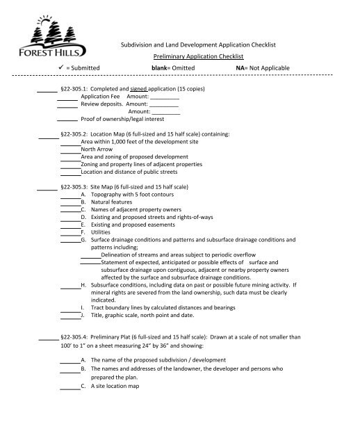
<strong>Subdivision</strong> <strong>and</strong> L<strong>and</strong> <strong>Development</strong> <strong>Application</strong> <strong>Checklist</strong>Preliminary <strong>Application</strong> <strong>Checklist</strong> = Submitted blank= Omitted NA= Not Applicable§22‐305.1: Completed <strong>and</strong> signed application (15 copies)<strong>Application</strong> Fee Amount: __ _______Review deposits. Amount: __ _______Amount: __ _____Proof of ownership/legal interest§22‐305.2: Location Map (6 full‐sized <strong>and</strong> 15 half scale) containing:Area within 1,000 feet of the development siteNorth ArrowArea <strong>and</strong> zoning of proposed developmentZoning <strong>and</strong> property lines of adjacent propertiesLocation <strong>and</strong> distance of public streets§22‐305.3: Site Map (6 full‐sized <strong>and</strong> 15 half scale)A. Topography with 5 foot contoursB. Natural featuresC. Names of adjacent property ownersD. Existing <strong>and</strong> proposed streets <strong>and</strong> rights‐of‐waysE. Existing <strong>and</strong> proposed easementsF. UtilitiesG. Surface drainage conditions <strong>and</strong> patterns <strong>and</strong> subsurface drainage conditions <strong>and</strong>patterns including;Delineation of streams <strong>and</strong> areas subject to periodic overflowStatement of expected, anticipated or possible effects of surface <strong>and</strong>subsurface drainage upon contiguous, adjacent or nearby property ownersaffected by the surface <strong>and</strong> subsurface drainage conditions.H. Subsurface conditions, including data on past or possible future mining activity. Ifmineral rights are severed from the l<strong>and</strong> ownership, such data must be clearlyindicated.I. Tract boundary lines by calculated distances <strong>and</strong> bearingsJ. Title, graphic scale, north point <strong>and</strong> date.§22‐305.4: Preliminary Plat (6 full‐sized <strong>and</strong> 15 half scale): Drawn at a scale of not smaller than100’ to 1” on a sheet measuring 24” by 36” <strong>and</strong> showing:A. The name of the proposed subdivision / developmentB. The names <strong>and</strong> addresses of the l<strong>and</strong>owner, the developer <strong>and</strong> persons whoprepared the plan.C. A site location map
Preliminary <strong>Subdivision</strong> <strong>and</strong> L<strong>and</strong> <strong>Development</strong> <strong>Checklist</strong> = Submitted blank= Omitted NA= Not ApplicableD. The zoning classification of the tract <strong>and</strong> a tabulation of data for the required zoningdistrict <strong>and</strong> the proposed development.E. A legend, a key plan, legends, notes, graphic scale, north point <strong>and</strong> date.F. The names <strong>and</strong> owners of the properties adjacent to the tract.G. Block <strong>and</strong> lot parcel numbers.H. The proposed street pattern, including:NamesWidths <strong>and</strong> purposes of easementsApproximate grades where they exceed 8%I. The layout of lotsDimensionsNumbersBuilding linesJ. Profiles, cross‐sections <strong>and</strong> specification for proposed street improvementsK. Profiles <strong>and</strong> other explanatory data concerning the installation ofwater distribution systemsstorm sewersanitary sewersL. The parcels of l<strong>and</strong> to be dedicated or reserved for schools, parks, playgrounds orother public or community uses.M. The location of all off‐street parking spaces <strong>and</strong> the total number of spaces to beprovided, in accordance with the requirements of the Zoning Ordinance [Chapter27].N. The location <strong>and</strong> design for all l<strong>and</strong>scaping <strong>and</strong> screening proposed showing theheight <strong>and</strong> type of screeningO. The location of the 100‐year floodplain as indicated on a certified FEMA map, withthe community panel number, map name, date <strong>and</strong> map panel numbersP. Certification of the registered professional l<strong>and</strong> surveyor as to the accuracy of thesurvey <strong>and</strong> plan.§22‐305.5: Engineering Report (15 copies) including the following data wherever pertinent:A. A report on the feasibility of connection to an existing sewerage system, includingthe distances to the nearest public sewer, the service load of the subdivision <strong>and</strong> thecapacity of the treatment plant.B. If connection to a public sewerage system is not feasible, a report on the feasibilityof a separate sewerage system <strong>and</strong> a treatment works, including the design,population, type <strong>and</strong> location of the treatment <strong>and</strong> receiving stream.C. If connection to a public or private sewerage system is not feasible, a report on thefeasibility of on‐lot sewage disposal, including a detailed map of the physicalconditions of the site, contours, finished grades, watercourses, ground water tableelevations <strong>and</strong> the results of soil absorption tests for each individual lot conductedin accordance with the recommended practices of the County Health Department.
Preliminary <strong>Subdivision</strong> <strong>and</strong> L<strong>and</strong> <strong>Development</strong> <strong>Checklist</strong> = Submitted blank= Omitted NA= Not ApplicableD. A geotechnical report prepared by a registered engineer with experience ingeotechnical engineering shall be submitted if required by the Borough GradingOrdinance [Chapter 9, Part 1].§22‐305.6: Erosion <strong>and</strong> Sedimentation Control Plan (15 copies): Shall specifically indicate allerosion <strong>and</strong> sedimentation control measures on the site. The plan shall meet the followingrequirements:A. Plan shall be prepared by persons trained <strong>and</strong> experienced in erosion <strong>and</strong>sedimentation control methods <strong>and</strong> techniques.B. Plan shall be designed to prevent accelerated erosion <strong>and</strong> sedimentation <strong>and</strong> shallconsider all factors which contribute to erosion <strong>and</strong> sedimentation including, butnot limited to:The topographic features of the project areaTypes, depth, slope <strong>and</strong> areal extent of the soilsProposed alteration to the areaAmount of runoff from the project area <strong>and</strong> the upstream watershed area.Staging of earth moving activitiesTemporary control measures <strong>and</strong> facilities for use during earth moving.Permanent control measures <strong>and</strong> facilities for long term protection.A maintenance program for the control facilities, including disposal ofmaterials removed from the control facilities or project area.C. The plan shall conform with all additional requirements specified by the BoroughCouncil, the PA DEP, ACCD <strong>and</strong> County Health Department.D. All plans shall be approved or permitted by the Allegheny County ConservationDistrict.§22‐305.7: Traffic Impact Study (15 copies)A. Any l<strong>and</strong> development or subdivision that will generate 75 or more average peakhour trips on adjacent streets shall be required to complete a traffic impact study.B. The Borough may require a traffic impact study for developments or changes in usesgenerating less than 75 trips to adjacent roadways, in cases where known trafficdeficiencies exist in the area. The Borough may waiver the study requirements foran individual development or change in use , where the development or change inuse was incorporated as part of a previously approved traffic impact study.C. The scope of the study, study area <strong>and</strong> methodology shall be approved by theZoning Officer or his or her designee before the study is initiated. The traffic impactstudy shall include the following if appropriate as determined by the Borough:(1) A brief description of proposed project in terms of l<strong>and</strong> use <strong>and</strong> magnitude(2) An inventory <strong>and</strong> analysis of existing roadway <strong>and</strong> traffic conditions in thesite including:(3) Proposed site generated traffic volumes
Preliminary <strong>Subdivision</strong> <strong>and</strong> L<strong>and</strong> <strong>Development</strong> <strong>Checklist</strong> = Submitted blank= Omitted NA= Not Applicable(4) Analysis of future traffic conditions(5) A description of future levels of service <strong>and</strong> their compliance with st<strong>and</strong>ardsfor traffic capacity of streets, intersections <strong>and</strong> driveways.(6) A description <strong>and</strong> analysis of the proposed access plan <strong>and</strong> site planD. Traffic Control Devices <strong>and</strong> Other Traffic Improvements. Whenever the trafficimpact study determines the need for a traffic signal or a regulatory sign, additionaltraffic lanes or other traffic improvements to be constructed, as a condition of thefinal plat, the applicant shall agree to construct the improvements at the applicant’scost, or in lieu thereof, reimburse the Borough for the cost of improvements.§22‐305.8: Text or Graphical materials (15 copies). The following text or graphical materialsshall be provided:A. Covenants, Grants <strong>and</strong> Easements. The substance of covenants, grants <strong>and</strong>easements or other restrictions proposed.B. Environmental Impact Statement. An environmental impact statement <strong>and</strong> analysisconsistent with Part 6 of Chapter 22 of the code of ordinances.§22‐305.8: A stormwater management plan, meeting the requirements of §22‐608.*This checklist is not intended to replace or override the requirements of the <strong>Subdivision</strong> <strong>and</strong> L<strong>and</strong><strong>Development</strong> Ordinance, but merely serve as a guide to assist in the application submission process.